You might like


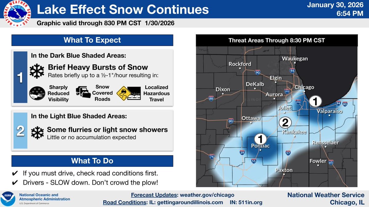
Scattered lake effect snow showers, some heavy, will continue thru 830 PM in the highlighted areas. The heaviest snow showers result in greatly reduced visibility, snow covered roads, and hazardous travel.

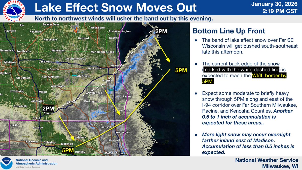
Lake effect snow will gradually end through 5PM. In the meantime expect some moderate to briefly heavy snow along and east of I-94 in Racine and Kenosha Counties. More light snow will occur overnight, but accumulations will generally be less than a half inch. #wiwx
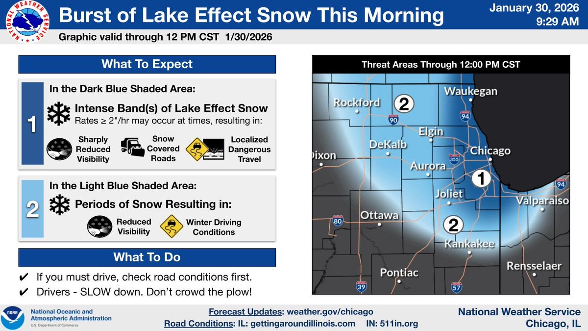
9:30 AM Update: An intense band of lake effect snow has moved into parts of northeast IL near the lake where rates could exceed 1-2"/hr beneath the band resulting in sharply reduced visibility and locally dangerous travel! Steadier light snow extends farther inland. #ILwx #INwx
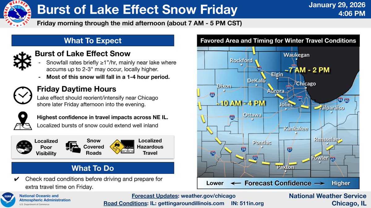
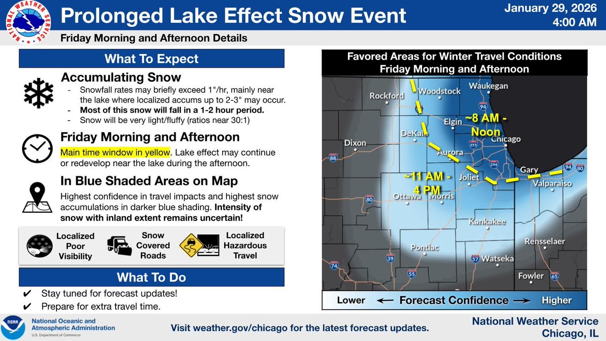
🧵(1/4) A prolonged lake effect snow event will affect portions of NW Indiana and NE Illinois from Friday morning through late Saturday. Here’s a look at the details for the Friday morning and afternoon burst of snow which could extend well inland in Illinois. #ILwx #INwx
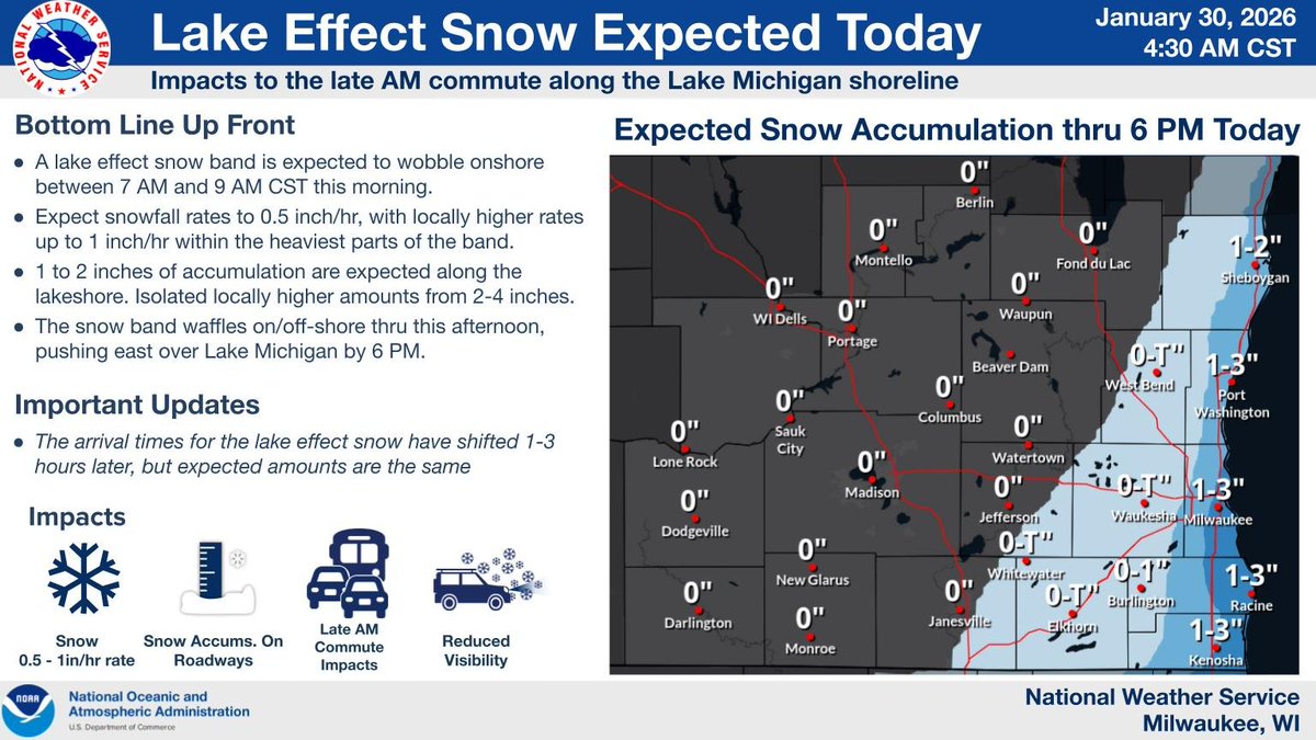
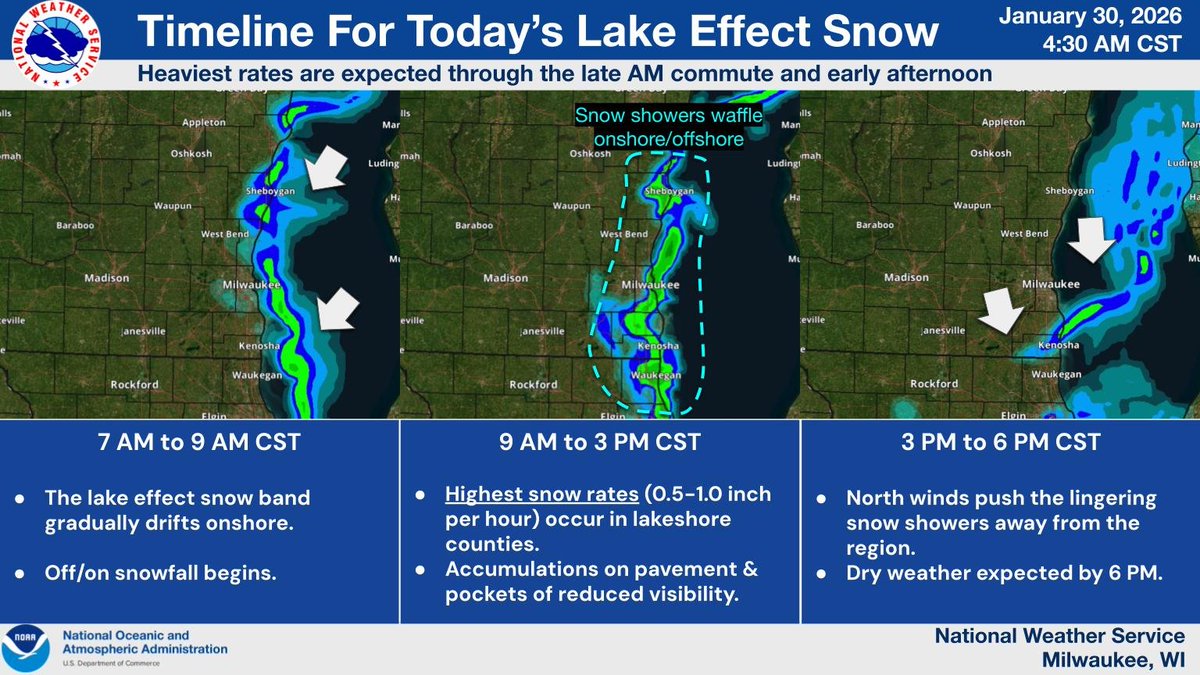
Though it's running a few hours late, lake effect snow is still expected to produce light accumulations along the shoreline today. Some slick spots and pockets of reduced visibility will be possible during the late AM commute / early afternoon. #wiwx #sewiwx
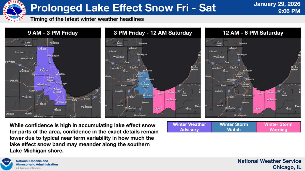
Here's an updated look at the upcoming lake effect snow. If planning to travel today or tomorrow near Lake Michigan, keep tabs on the forecast and road conditions! #ILwx #INwx
Overall no big changes to the forecast this evening in regards to tomorrow's lake effect snow. However, confidence is growing for a band of heavy lake effect snow in NW IN and so we have upgraded to a Winter Storm Warning for Lake (IN) and Porter Counties. #ILwx #INwx
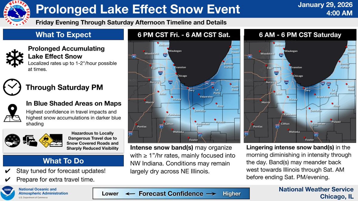
A prolonged lake effect snow event will affect portions of NW Indiana and NE Illinois from Friday AM thru late Saturday. Our forecast graphics in this post provide a look at the details, broken up between Friday AM/afternoon and Friday evening thru Saturday PM. #ILwx #INwx (1/2)
A prolonged period of travel impacts – primarily from lake effect snow – appears increasingly likely in some areas in the early Friday AM through Saturday night time frame. However, considerable uncertainty remains in forecast specifics, so stay tuned for updates. #ILwx #INwx
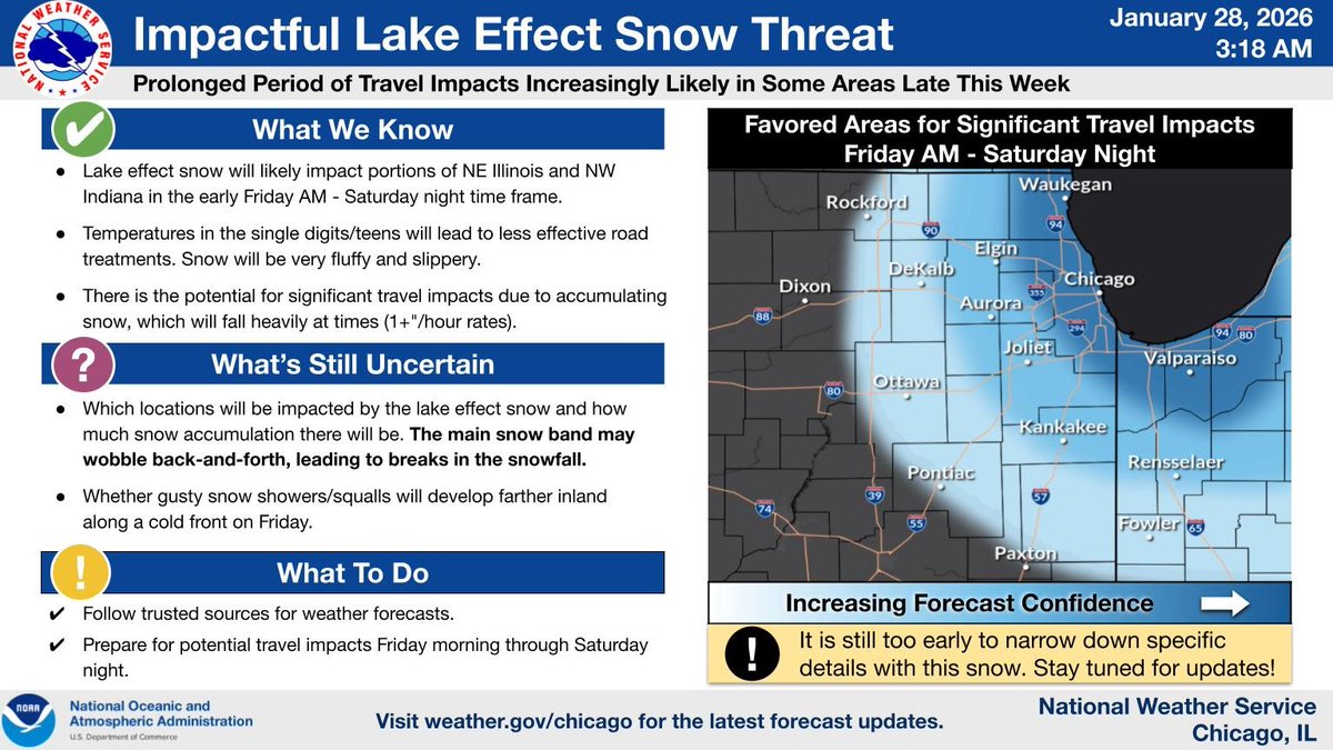
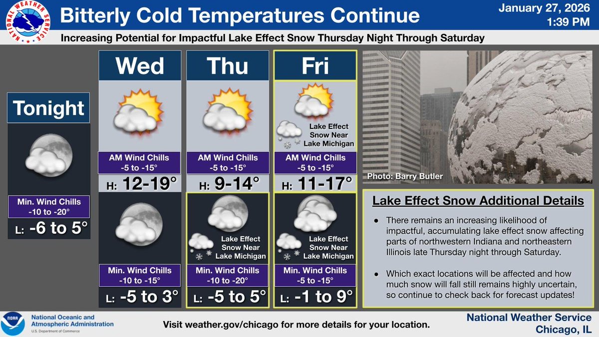
Bitterly cold weather persists this week, with early morning wind chills approaching -15 to -20 F at times. There also remains an increasing potential for impactful lake effect snow affecting part of the area in the Thursday night through Saturday time frame. #ILwx #INwx
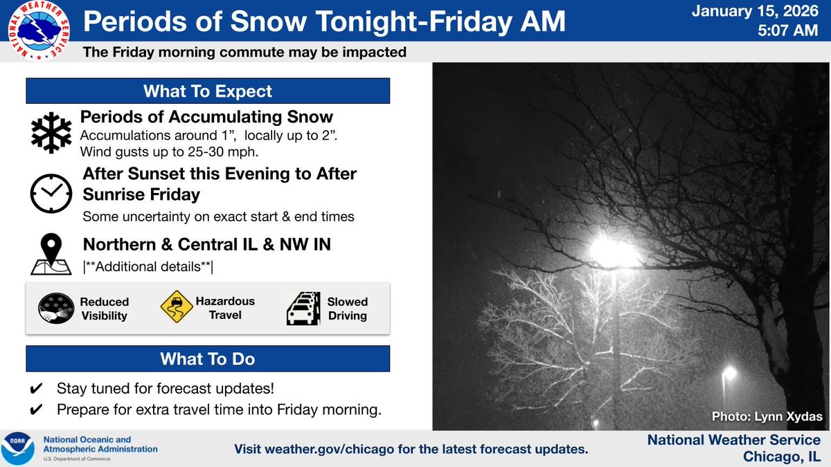
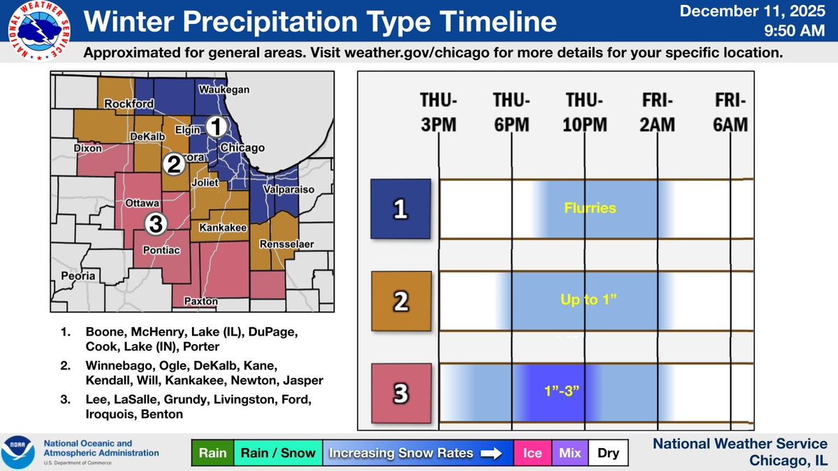
Accumulating snow is expected tonight, developing after sunset and continuing past sunrise Friday. Amounts of around an inch to locally 2 inches are expected. This may lead to slippery road conditions overnight and Friday morning. #ILwx #INwx
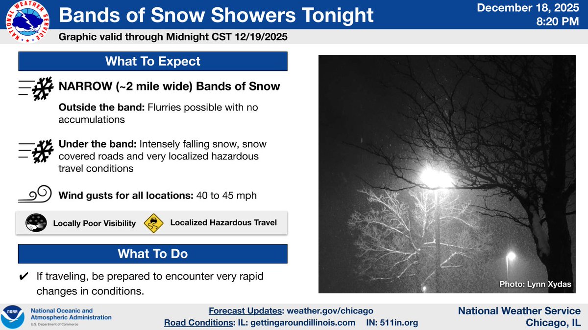
Very narrow bands of more intense snow are moving over IL. For very few locations that end up under one of these bands, look for intensely falling, wind driven snow resulting in hazardous travel. Motorists: be prepared for very rapid changes to conditions tonight. #ILwx #INwx
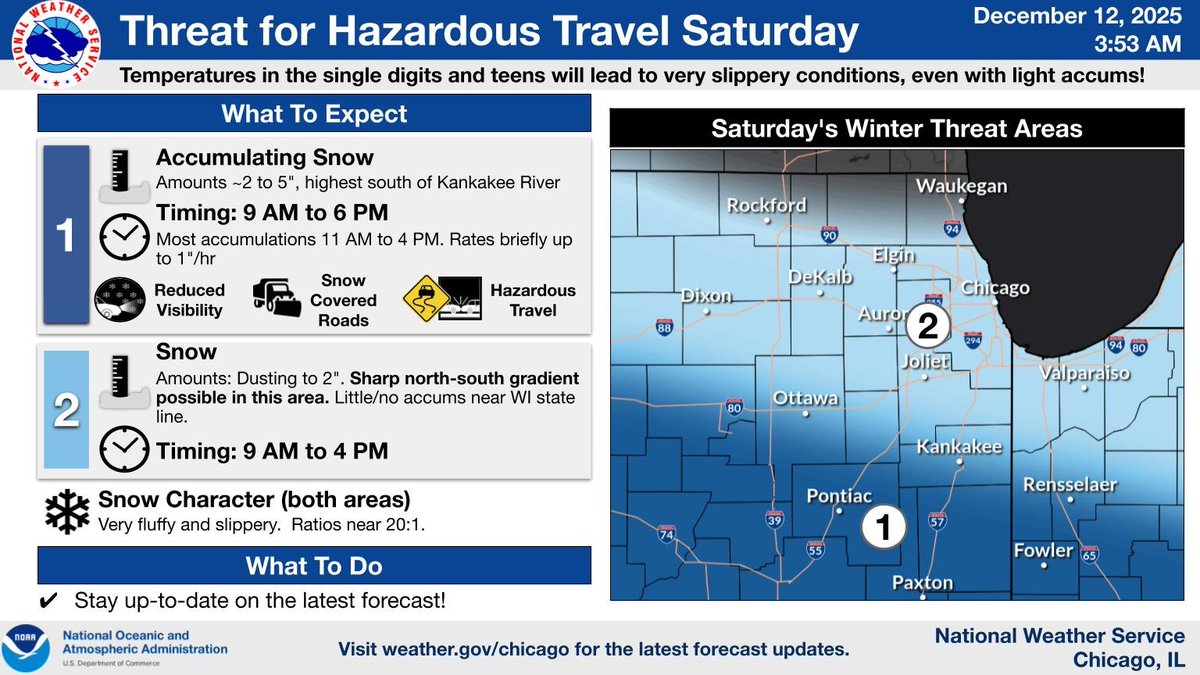
Another round of snow is on deck on Sat. Some uncertainty in exact amounts remains, w/ the greatest potential for hazardous travel is near/south of I-80. Cold temperatures will lead to slippery conditions, even w/ light accumulations. Amounts diminish towards WI state line. (1/2)
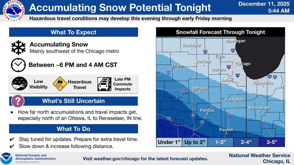
The chances for accumulating snow this evening look to be focused well southwest of the the Chicago Metro Area across northwestern and central Illinois. #ILwx #INwx
Another quick moving weather system will produce accumulating snow across portions of the area this evening and overnight leading to hazardous travel conditions. The vast majority of the snow is currently anticipated to fall mainly southwest of the Chicago metro. #ILwx #INwx
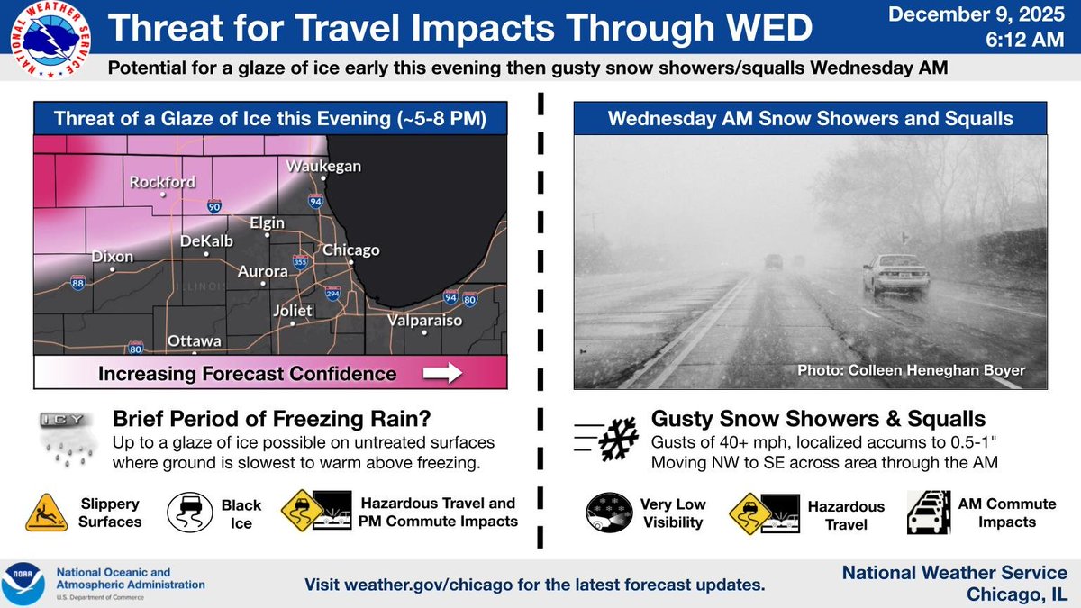
A period of wind-whipped snow is expected this morning and overlap part of the AM commute. The combination of low visibility and partially slush covered roads may result in locally hazardous travel conditions. Allow extra time and take it slow if you encounter snow! #ILwx #INwx

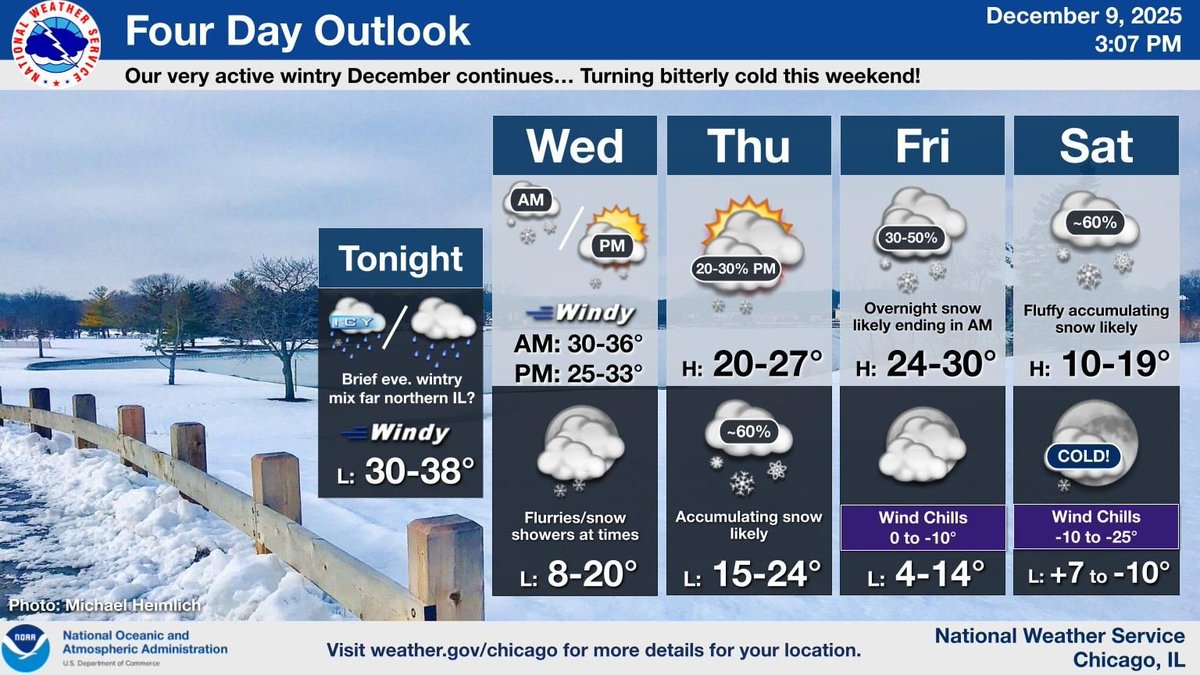
Beat goes on in our active, wintry month thus far. Patchy slick spots possible across parts of far northern IL this eve, followed by a short period of wind-whipped snow Wed AM. More accumulating snow likely Thu night-early Fri & then Sat, bitterly cold Sat night. #ILwx #INwx
Winter weather may impact travel this evening and again WED AM. Rain may briefly overlap with freezing pavement, potentially causing slick travel conditions early evening (see inset map). The WED AM commute could also be impacted by wind whipped snow showers/squalls. #ILwx #INwx
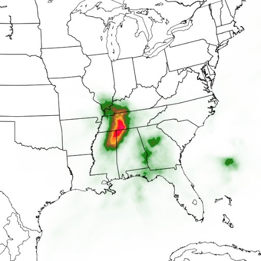
LOT issues Summary Local Storm Report, 187 out of 187 reports were previously sent and not repeated here. mesonet.agron.iastate.edu/lsr/?by=wfo&wf…


United States Trends
- 1. Epstein N/A
- 2. #VERZUZ N/A
- 3. Mike Will N/A
- 4. #DragRace N/A
- 5. Don Lemon N/A
- 6. Pusha N/A
- 7. Jay Z N/A
- 8. #OPLive N/A
- 9. Hit Boy N/A
- 10. #SmackDown N/A
- 11. Hanoi Jane N/A
- 12. Jeremy Fears N/A
- 13. Bill Gates N/A
- 14. Michigan State N/A
- 15. Izzo N/A
- 16. Michael Watts N/A
- 17. #Unrivaled N/A
- 18. Catherine O'Hara N/A
- 19. Helicoide N/A
- 20. Mara N/A
You might like
-
 IEMBot LOT
@iembot_lot -
 trash jones
@jzux -
 Kenny S
@SchtillRokken -
 Lake & McHenry County Scanner
@LMCScanner -
 Dr. Merritt Turetsky
@queenofpeat -
 Shery Ahn
@SheryAhnNews -
 Bflyer
@rfattore -
 T For Faith & Country 🇺🇸🇺🇸🇺🇸🇺🇸🇺🇸
@ToriDi -
 Notorious Z.I.G.
@ZiggyKois -
 ComEd
ComEd
@ComEd -
 C7_Vette
@C7_Vette -
 Bradley Scott 🙏🇺🇸
@Hoosiers1986 -
 bugatti spaceships 🚀👩🏾🚀🇵🇸🇨🇩🇸🇩
@astronaia -
 John McCollister
@SenMcCollister -
 JB Plutocrat
@TaxingU4Equity
Something went wrong.
Something went wrong.