#inwx search results
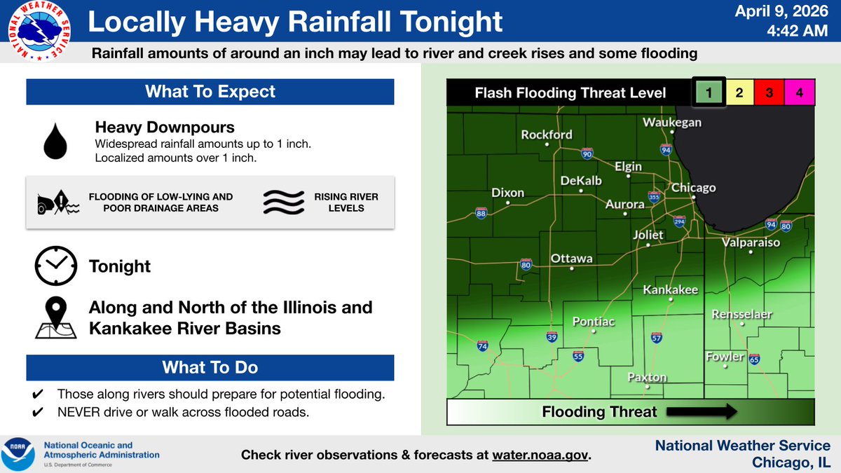
Additional showers (and some embedded thunderstorms) are likely tonight. While severe weather is not expected, locally heavy rainfall may lead to rises on area rivers and creeks and cause some flooding. #ILwx #INwx

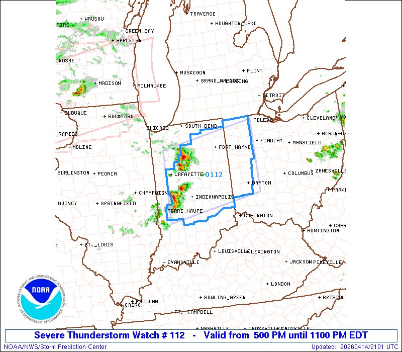
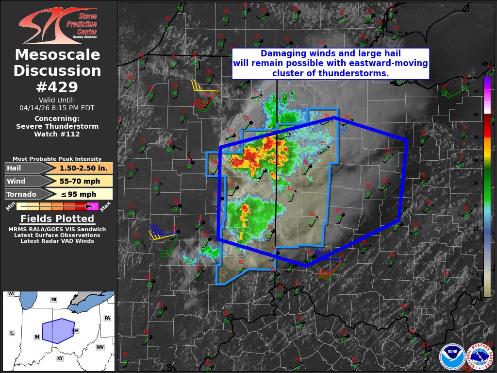
4:02pm CDT #SPC_Watch WW 112 SEVERE TSTM IN OH 142100Z - 150300Z, #inwx #ohwx, spc.noaa.gov/products/watch…

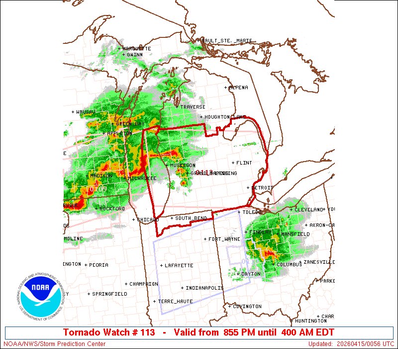
7:57pm CDT #SPC_Watch WW 113 TORNADO IN MI LE LH LM 150055Z - 150800Z, #inwx #miwx #lewx #lhwx #lmwx, spc.noaa.gov/products/watch…
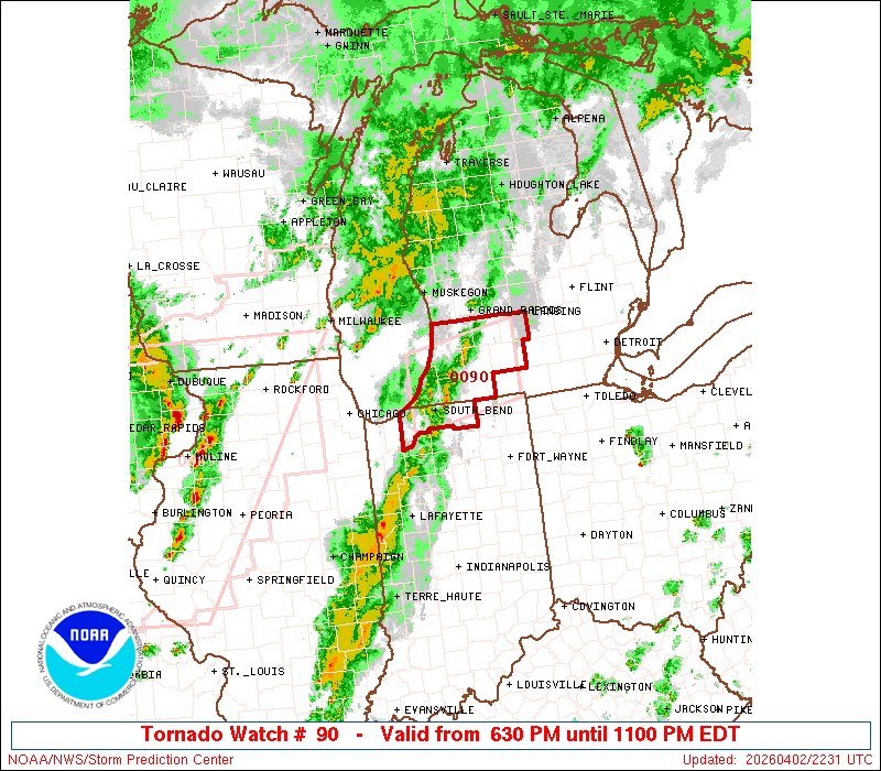
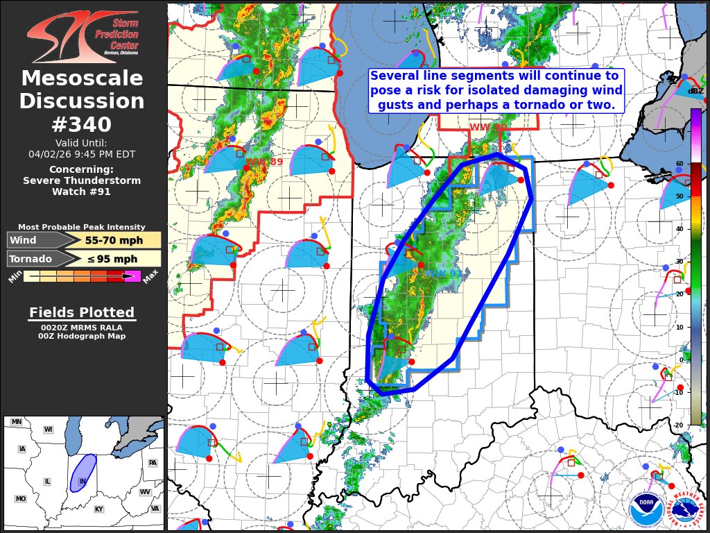
5:32pm CDT #SPC_Watch WW 90 TORNADO IN MI 022230Z - 030300Z, #inwx #miwx, spc.noaa.gov/products/watch…

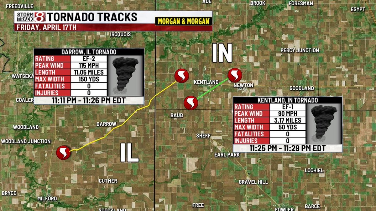
CONFIRMED TORNADOES: 2 tornadoes have been confirmed in Newton County, IN from last Friday night. This brings the statewide total for 2026 to 14 so far. #inwx wishtv.com/weather
Milder temperatures are expected this week. There is a chance of thunderstorms mainly near/south of I-88 Tuesday evening. After a brief break, greater shower/storm chances are expected as cold front passes toward the end of the week. #ILwx #INwx


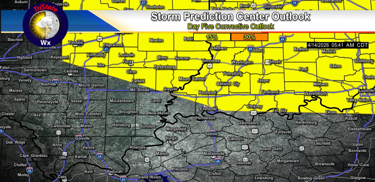
4/14/26 The Storm Prediction Center has placed portions of the tri-state in a 15% Risk area for Severe Storms on Saturday afternoon and evening. Damaging winds will be the main concern, but an isolated spin-up tornado will be possible. #tristatewx #inwx #ilwx #kywx


It may take some time for storm to arrive ⛈️ be prepared to get your alerts 📲🔊 on your phone #inwx #miwx
2:12pm CDT #SPC_Watch WW 102 SEVERE TSTM IL IN MI LM 131910Z - 140200Z, #ilwx #inwx #miwx #lmwx, spc.noaa.gov/products/watch…

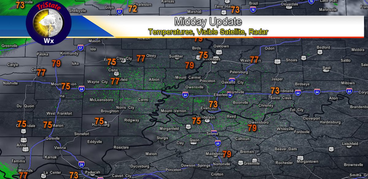
4/15/26 Midday Update: Clouds continue to increase from the West. Some Showers may clip our northwestern counties this afternoon. Temperatures are in the mid to upper 70s. #tristatewx #inwx #ilwx #kywx

You could very well chase 3 areas today. I wouldn't be surprised if the SPC made some major adjustments to the risk outlook this afternoon... #ILwx #INwx #WIwx #OHwx
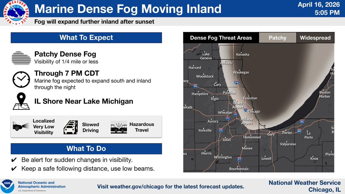
4/16/26 (No Audio) LIVE TristateWx HD Doppler Radar Stream #tristatewx #inwx #ilwx #kywx x.com/i/broadcasts/1…
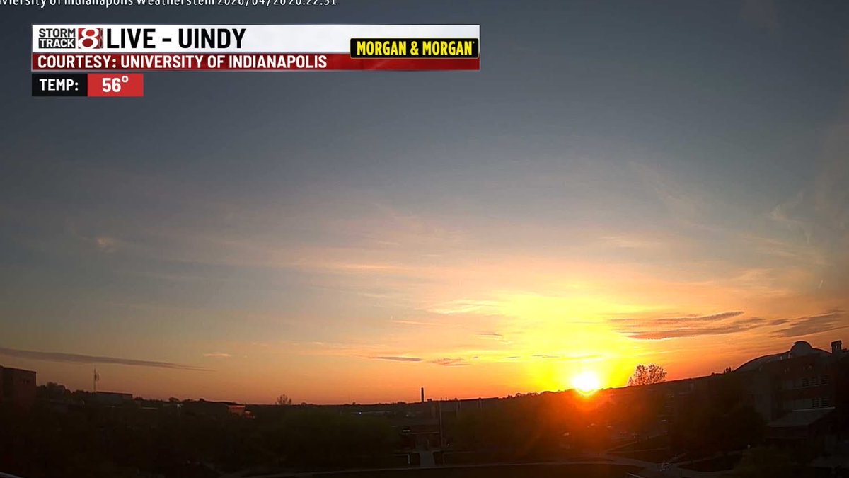
What a great sunset on this Monday evening. Highs today were in the 50s and low 60s but we'll push it back into the mid to upper 70s on Tuesday. Some rain/thunder could occur late Tuesday evening into Tuesday night. #inwx wishtv.com/weather
CONFIRMED TORNADOES: 2 tornadoes have been confirmed in Newton County, IN from last Friday night. This brings the statewide total for 2026 to 14 so far. #inwx wishtv.com/weather
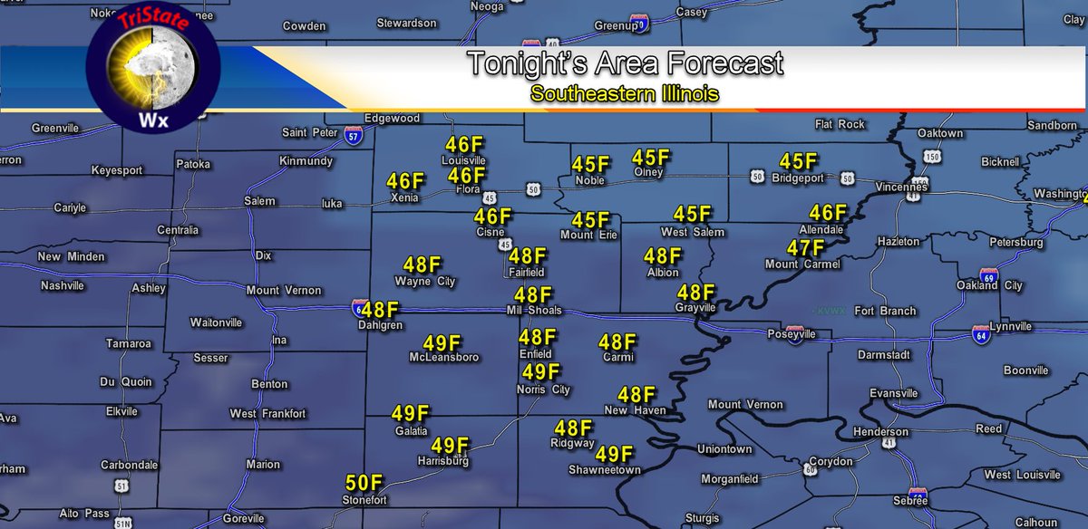
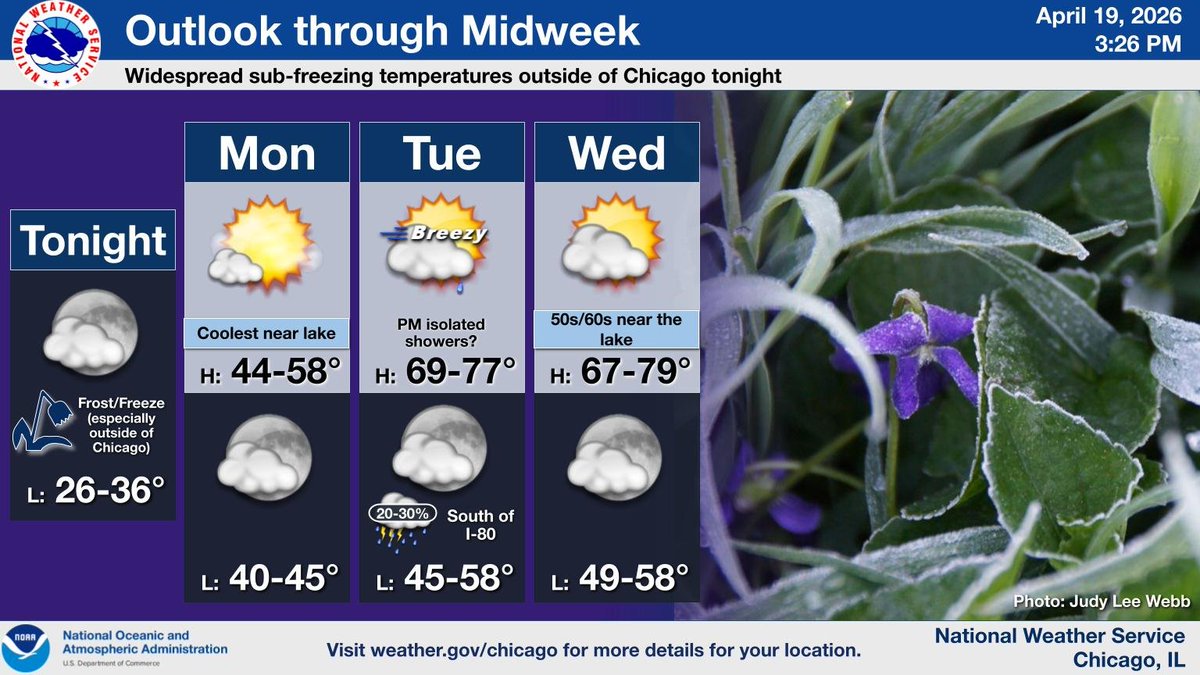
4/21/26 Tonight's Forecast: Mostly Clear and Cool. Lows will be in the mid to upper 40s. #tristatewx #inwx #ilwx #kywx


Last Freeze 🥶 It is possible 4/20/26 could be the last freeze of the season but the rule of thumb remains to wait to plant the garden until AFTER Mother's Day. #inwx #miwx

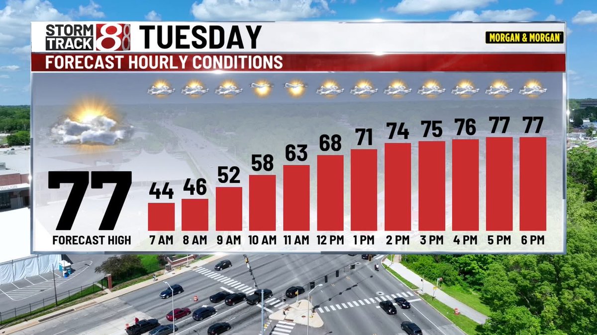
A windy, warm up is to get underway Tuesday. After another cool morning - temperatures will jump into the 70s behind a passing warm front. Winds late day could gust to 40mph. #INwx

This is the coolest but the BRIGHTEST afternoon in two weeks. April sunshine has been struggling with only 1/3 the normal sunshine to-date. #INwx


Weather Reporters Are Much Needed In Fountain County...Newton, Hillsboro, Wallace, and Kingman Areas weather.gov/ind/incocorahs #INwx #nwsind #CoCoRaHS #CoCoRaHSIN


After one more cool night a warm up starts Tuesday and we'll have several chances for rain this week. Go to this link for my updated blog with the work week forecast: fox59.com/weather/a-warm… #nwsind #INwx @CBS4Indy @WJJK1045 @939xindy @ChrisWrightcbs4 @theWXauthority


Matt's Weather Rapport: A deep dive into some of the most iconic #tornado images in U.S. history, how they came to be and who was involved. Details: matttsweatherrapport.blogspot.com/2026/04/the-mo… #kswx #inwx #ohwx #mowx #txwx #alwx
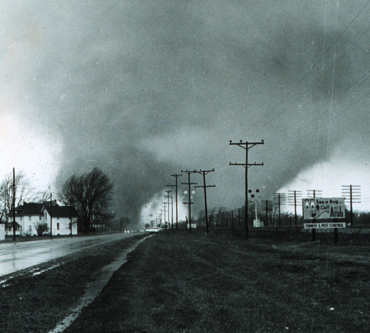

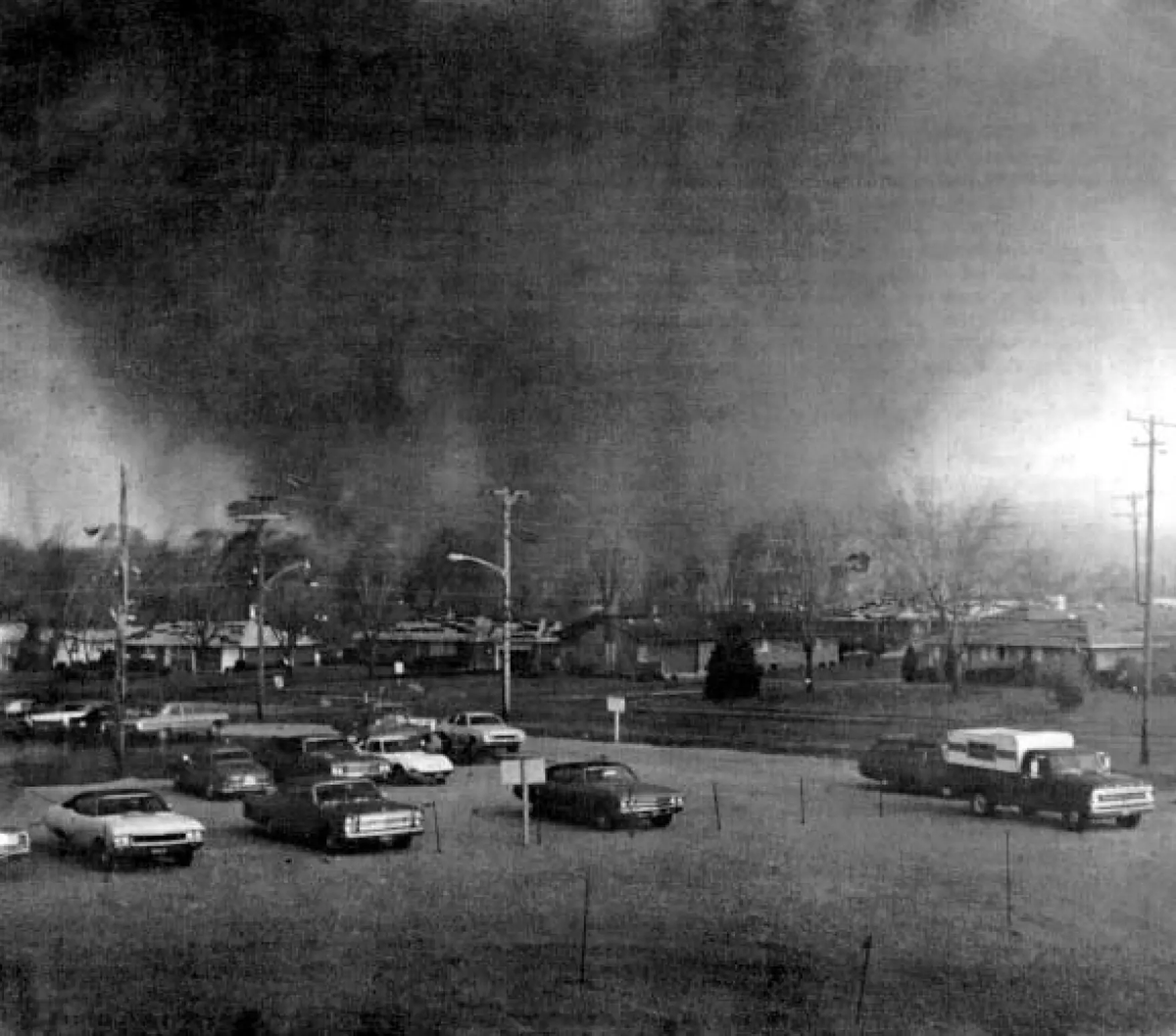
[Delayed Report] On Apr 17, at 10:25 PM CDT, 2 SSW Kentland [Newton Co, IN] NWS Storm Survey reports Tornado. An NWS damage survey confirmed an EF-1 tornado with peak winds near 90 mph, path width of 3.2 miles, and maximum width of 50 yards... #inwx mesonet.agron.iastate.edu/lsr/?by=wfo&wf…
![MidwestWeather3's tweet image. [Delayed Report] On Apr 17, at 10:25 PM CDT, 2 SSW Kentland [Newton Co, IN] NWS Storm Survey reports Tornado. An NWS damage survey confirmed an EF-1 tornado with peak winds near 90 mph, path width of 3.2 miles, and maximum width of 50 yards... #inwx mesonet.agron.iastate.edu/lsr/?by=wfo&wf…](https://pbs.twimg.com/media/HGX6TtxWQAAXwzY.jpg)

[Delayed Report] On Apr 17, at 10:25 PM CDT, 2 SSW Kentland [Newton Co, IN] NWS Storm Survey reports Tornado. An NWS damage survey confirmed an EF-1 tornado with peak winds near 90 mph, path width of 3.2 miles, and maximum width of 50 yards... #inwx mesonet.agron.iastate.edu/lsr/?by=wfo&wf…
![DL_NERV's tweet image. [Delayed Report] On Apr 17, at 10:25 PM CDT, 2 SSW Kentland [Newton Co, IN] NWS Storm Survey reports Tornado. An NWS damage survey confirmed an EF-1 tornado with peak winds near 90 mph, path width of 3.2 miles, and maximum width of 50 yards... #inwx mesonet.agron.iastate.edu/lsr/?by=wfo&wf…](https://pbs.twimg.com/media/HGX6TtYXUAAKkr9.jpg)
For those who are not so happy about the cooler weather... Temperatures will quickly rise into Tuesday! Storm chances return late Tues evening into the overnight. Isolated showers and a stray storm are possible Wednesday as well. Expect highs in the 70s the next few days. #inwx


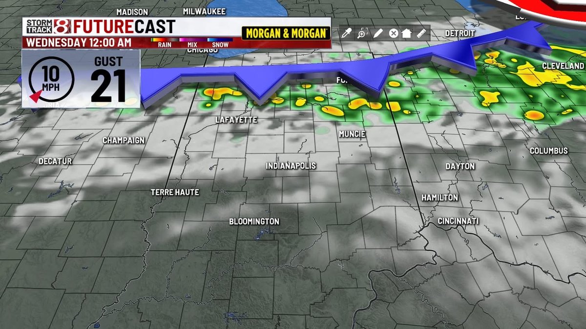
Next round of rain and thunder 🌩️? Rumbles into town overnight Tuesday into Wednesday. #Indy #INwx #AGwx #Plant26
Milder temperatures are expected this week. There is a chance of thunderstorms mainly near/south of I-88 Tuesday evening. After a brief break, greater shower/storm chances are expected as cold front passes toward the end of the week. #ILwx #INwx

4/20/26 Midday Update: Mostly Sunny skies across the tri-state area. Temperatures have warmed into the mid to upper 50s. Plenty of sunshine this afternoon with highs topping out in the mid to upper 60s. #tristatewx #inwx #ilwx #kywx

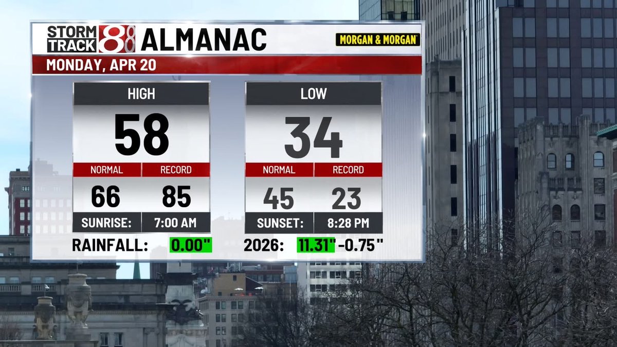
Happy Monday! Beautiful blue sky today after a chilly morning in the 20s and 30s across Central Indiana. #inwx


Warming Back Up (For Now); Early May Frost Threat…indywx.com/warming-back-u… #Indy #INwx #AGwx #Plant26


Additional showers (and some embedded thunderstorms) are likely tonight. While severe weather is not expected, locally heavy rainfall may lead to rises on area rivers and creeks and cause some flooding. #ILwx #INwx
4:02pm CDT #SPC_Watch WW 112 SEVERE TSTM IN OH 142100Z - 150300Z, #inwx #ohwx, spc.noaa.gov/products/watch…

#WPC_MD 0117 affecting central/northern Illinois, much of Wisconsin, upper Peninsula of Michigan, western Indiana, #miwx #inwx #wiwx #ilwx #iawx, wpc.ncep.noaa.gov/metwatch/metwa…

Milder temperatures are expected this week. There is a chance of thunderstorms mainly near/south of I-88 Tuesday evening. After a brief break, greater shower/storm chances are expected as cold front passes toward the end of the week. #ILwx #INwx
7:57pm CDT #SPC_Watch WW 113 TORNADO IN MI LE LH LM 150055Z - 150800Z, #inwx #miwx #lewx #lhwx #lmwx, spc.noaa.gov/products/watch…
5:32pm CDT #SPC_Watch WW 90 TORNADO IN MI 022230Z - 030300Z, #inwx #miwx, spc.noaa.gov/products/watch…
A line of strong thunderstorms is nearing the state line with a history of widespread damaging winds and tornadoes. The line is expected to continue to produce damaging winds as it moves into Indiana with the potential for additional tornadoes. #INwx

2:12pm CDT #SPC_Watch WW 102 SEVERE TSTM IL IN MI LM 131910Z - 140200Z, #ilwx #inwx #miwx #lmwx, spc.noaa.gov/products/watch…
Weather Reporters Are Much Needed In Fountain County...Newton, Hillsboro, Wallace, and Kingman Areas weather.gov/ind/incocorahs #INwx #nwsind #CoCoRaHS #CoCoRaHSIN
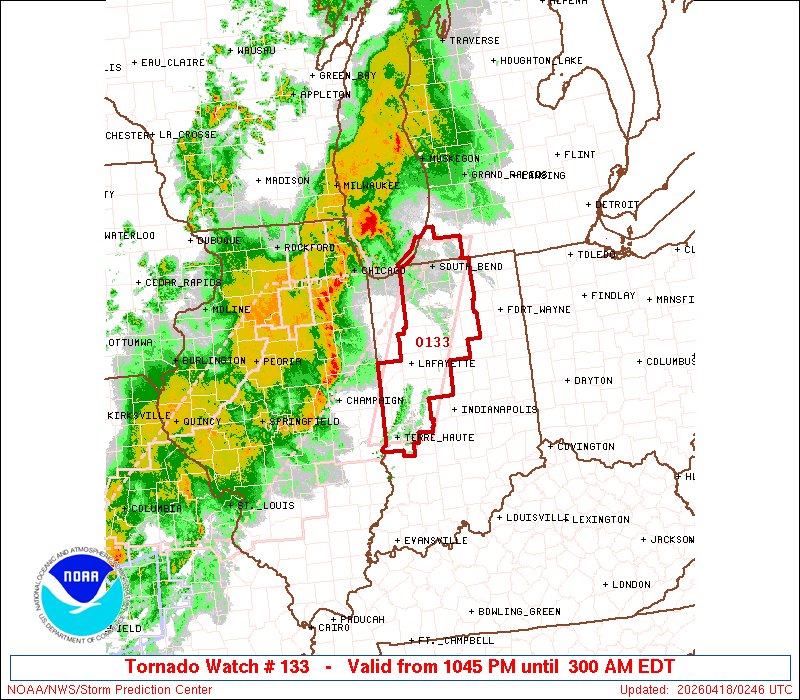
9:47pm CDT #SPC_Watch WW 133 TORNADO IN MI LM 180245Z - 180700Z, #inwx #miwx #lmwx, spc.noaa.gov/products/watch…
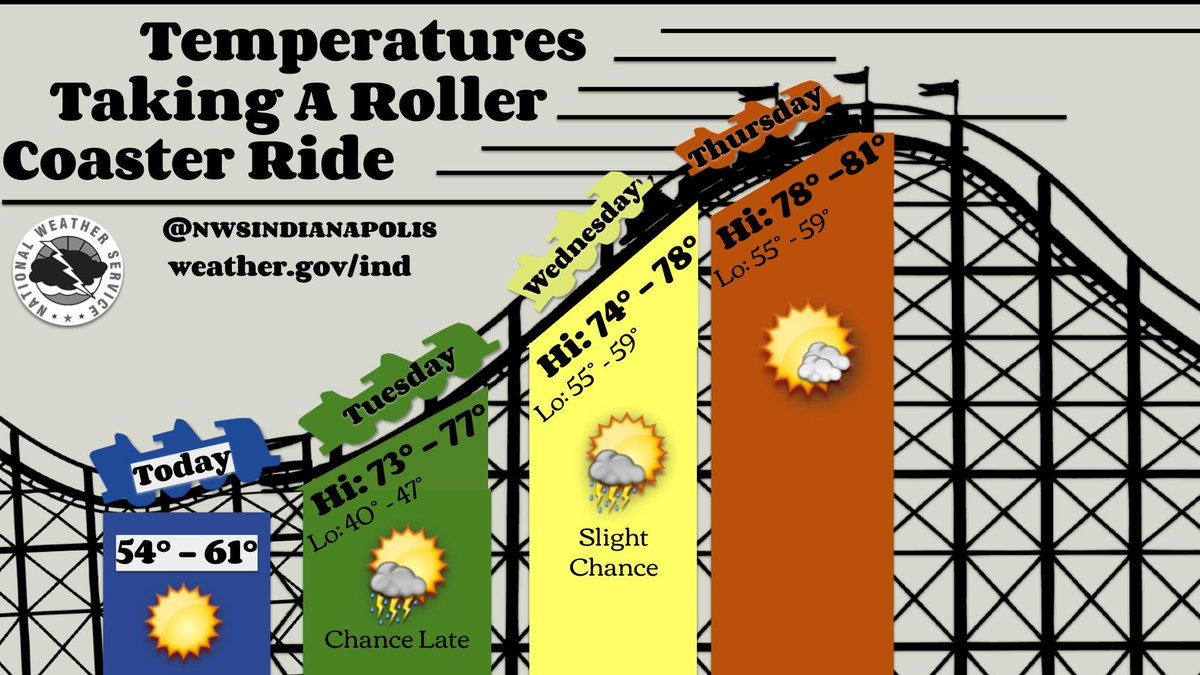
Spring is rollercoaster season in Indiana...at least when it comes to temperatures. After a frosty start to the week, temperatures quickly climb back to the 70s and 80s the next few days! Looking ahead, slightly cooler and wetter weather returns for the end of the month. #inwx
We have one more severe weather day to get through this week in this relentless weather pattern. Storms are expected to develop west of the MS River late Friday afternoon and progress east across the area through the evening. Stay tuned to the latest forecast updates! #ILwx #INwx

Showers and storms are possible once again tonight as a warm front moves northward. Some storm may be strong to severe, though the threat for severe storms should diminish after midnight. Showers are expected to continue through daybreak tomorrow. #ILwx #INwx

Something went wrong.
Something went wrong.
United States Trends
- 1. #WWERaw N/A
- 2. #bucciovertimechallenge N/A
- 3. Sol Ruca N/A
- 4. #RawAfterMania N/A
- 5. Brandon Ingram N/A
- 6. Penguins N/A
- 7. Pens N/A
- 8. Jalen Johnson N/A
- 9. #IgniteTheOrange N/A
- 10. Street Profits N/A
- 11. Flyers N/A
- 12. Ethan Page N/A
- 13. Thune N/A
- 14. CJ McCollum N/A
- 15. Brunson N/A
- 16. Laura G N/A
- 17. Mike Brown N/A
- 18. Letang N/A
- 19. Porter Martone N/A
- 20. Zaria N/A