
You might like


Lake Tahoe 07.01.25.1600pdt: Thunderstorm, in progress, n. #California, 10^13 J., kinetic energy in joules. Rf. #tropicalstorm, e. Pacific, #hurricane #flossie. perplexity.ai/search/lake-ta…

#TropicalStorm 07.01.25.1540pdt: Energy, rated in joules, #Hurricane, E. Pacific, Mexico. Rf. #Flossie and #NWS. perplexity.ai/search/energy-…

Hollywood Hills 01/08/25/2100PST: Astronomers up on Mount Wilson front row seat as ##wildfire creeps up hill. rf #PalisadesFire , Beverly Hills #California evac over #sunsetfire . Observatory live webcam: shorturl.at/uZPdE

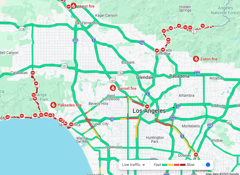
Beverly Hills Evac 01/08/25/2040PST: Google traffic shows limited options for #Palisadesfire and some others #sunsetfire and Hollywood Hills, #California as #wildfire menace continues , Los Angeles. Map: shorturl.at/n3ifx
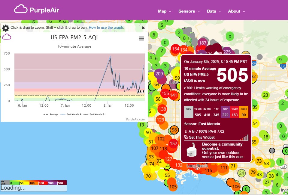
Hollywood Hills AQI 01/08/25/2020PST: Los Angeles #wildfire consuming available O2, "health emergency " an understatement, air is virtually unbreathable in up/downwind zones, Pasadena, #California and nearby. rf #PalisadesFire #sunsetfire Purple Air map: shorturl.at/NgcN9
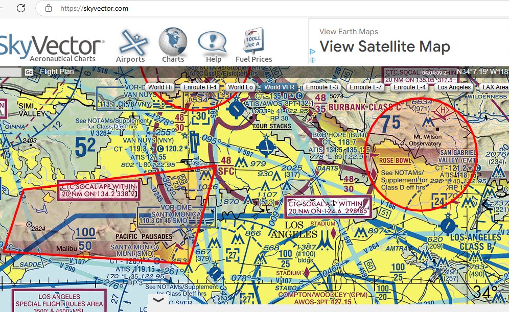
Hollywood Hills 01/08/25/2020PST: FAA no-fly restrictions over Los Angeles, #California including area above #PalisadesFire, other local #wildfire hotspots. SkyVector map: shorturl.at/us4Ki

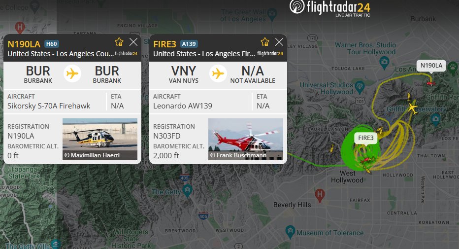
#Hollywood 01/08/25/2000PST: Rotary wing #wildfire suppression aircraft over Hollywood Hills, Los Angeles, #California numerous locations, tracked on available online resources. rf #PalisadesFire Flight Radar 24 link: shorturl.at/o2XUs
#MountainFire 11/07/24/1100PST: TFRs posted by FAA over #wildfire, SoCal, no-fly zone making access for firefighting aerial assets. Trending: #HurricaneRafael over GOM following #Cuba landfall, further #tropicalstorm development expected. SkyVector link: shorturl.at/UvjgR

FB #Tahoe 09/11/24/1345PDT: Downslope Washoe Zephyr direction, view from Chocolate Peak, 9409', vic. #DavisFire; gusts fueling #wildfire in valley below. Peak Visor 3d link with labels: shorturl.at/uDdOy
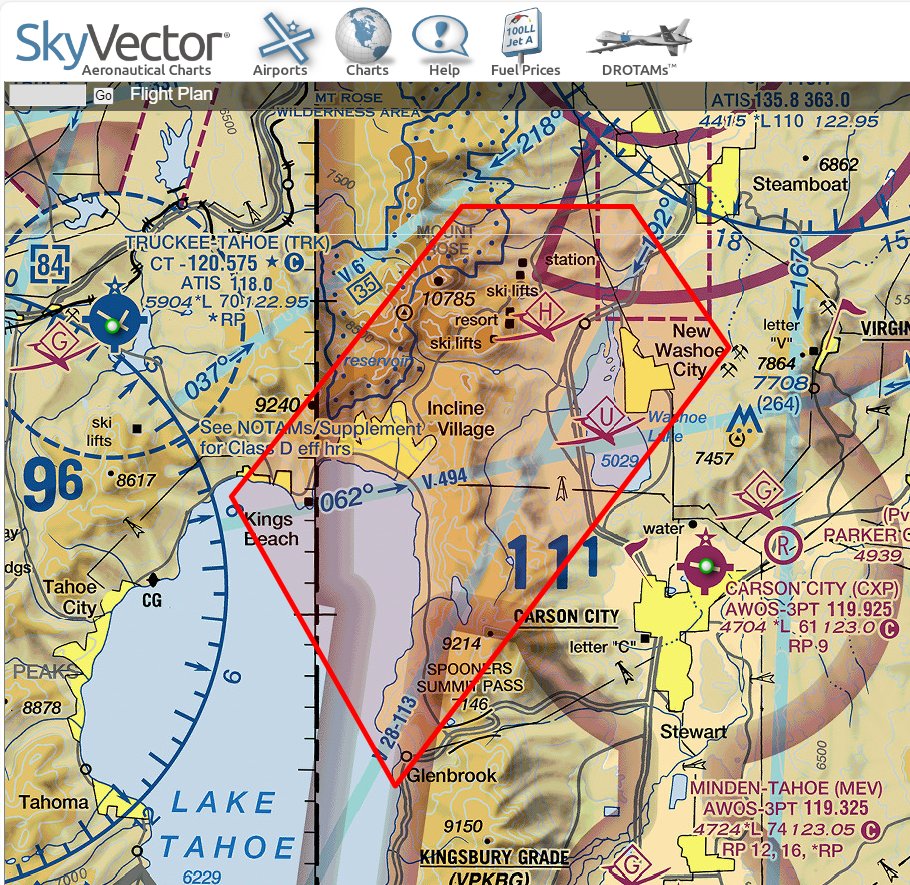
FB #Tahoe 09/11/24/1100PDT: Dramatic increase in FAA- TFR no-fly zone, #DavisFire, to include #wildfire aircraft water access points, N. Lake Tahoe. Fwd: #TimWalz, CSM, 1-125 Arty., MNNG. Sky Vector link: shorturl.at/x6rIT

FB #Tahoe 09 /11/24/1000PDT: #DavisFire "superscooper" aircraft drop into lake, fill up on water, what about fish? A big surprise when bombay doors open over Washoe Valley #wildfire, plunging hundreds of feet, horrible death, into blazing inferno. Attn: animal rights activists..

FB #Tahoe 09/10/24/1300PDT: N. Nevada, #DavisFire, Washoe County, time-lapse, 6-hr time-lapse, today, Alert #Wildfire Org.> NOAA Link: shorturl.at/UUWSN
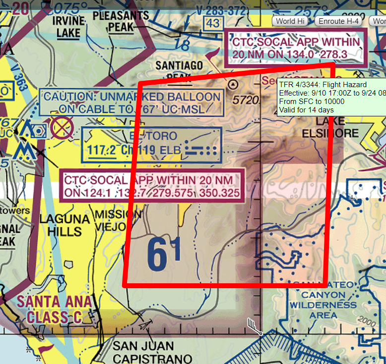
FB #Tahoe 09/10/24/1200PDT: FAA no-fly zone, #AirportFire, S. California, OC vic., Sky Vector link: #wildfire proximity: shorturl.at/DwkKG
Firebase #Tahoe Cmd HQ 09/09/24/1922PDT: FAA no-fly for commercial-private aircraft w/rf: #DavisFire, N. Nevada, TFR 4-2096. FWD: #TimWalz, CSM, 1-125 Arty Regt, MN NG-- rf: #wildfire. Sky Vector Link: skyvector.com/?ll=39.2345135…

There was a login to your account @firebasetahoe from a new device on Aug 16, 2023. Review it now.
#Mauifires 08/09/23/1600PDT: Serious aerial activity over island, Hawaii, as #wildfire burns uncontrolled: US Army aircraft multiple locations, others circle above Lahaina--Maui--Flight Radar link: flightradar24.com/multiview/3185…

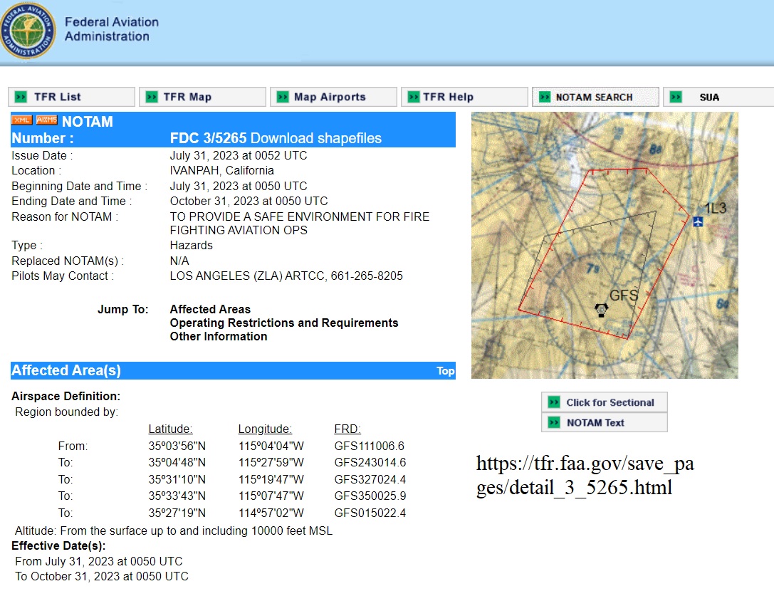
#YorkFire 08/01/23/1305PDT: FAA NOTAM posted, no fly zone over Mojave Reserve, SW Las Vegas, Sky Vector link: skyvector.com/?ll=35.8050059…

#AirQualityAlert, Manhattan 06/07/23/1645PDT: Interactive AQI indicating 201-300+ range for New York, regional diffusion, fallout cloud, Canada #wildfire. Air Now link: gispub.epa.gov/airnow/?contou…


United States Trends
- 1. #BaddiesUSA 63.6K posts
- 2. TOP CALL 3,544 posts
- 3. #centralwOrldXmasXFreenBecky 409K posts
- 4. SAROCHA REBECCA DISNEY AT CTW 426K posts
- 5. AI Alert 1,157 posts
- 6. Rams 29.8K posts
- 7. #LAShortnSweet 22.9K posts
- 8. Market Focus 2,390 posts
- 9. Token Signal 1,567 posts
- 10. Check Analyze N/A
- 11. Scotty 10.2K posts
- 12. #LingOrmDiorAmbassador 216K posts
- 13. Chip Kelly 8,968 posts
- 14. sabrina 63.8K posts
- 15. #ITWelcomeToDerry 16.7K posts
- 16. Raiders 68K posts
- 17. Vin Diesel 1,459 posts
- 18. Ahna 7,613 posts
- 19. Stacey 24K posts
- 20. billie 20.4K posts
You might like
-
 DJ Hopson 🇺🇸 VOTED . NO CALL GIRLS . BLOCKED
@Hoppy712 -
 🇺🇸𝒫𝒶𝓉𝓇𝒾𝑜𝓉 𝒲𝒞 🇺🇸
@CA_Patriot9 -
 Salty Saves
@SaltySaves -
 あしゃぽ〜
あしゃぽ〜
@Asyapow_sx -
 Jen 🍊
Jen 🍊
@luvjenuine -
 L❤ve🧡thy💛Neighbor
@lisahawkfan -
 Scott H.
@ScottH_Thoughts -
 Eddie Schweitzer
@EddieSchweitze7 -
 Andrea for Missing
@Andreawk_RI -
 Feminine Perspective Magazine
@RINJPress -
 Aric
Aric
@Aric_with_a_A -
 The Scoop with Barb
@scoop_barb -
 S.G.
S.G.
@SG29068234 -
 Jeneen Dove
@DoveJeneen
Something went wrong.
Something went wrong.