Myrtle Beach Aware
@mbAwareWx
Myrtle Beach Aware is a hyper-local, independent weather and storm chasing media outlet dedicated to providing real-time weather coverage.
🇺🇸 Today we honor all who have served. Your courage, sacrifice, and dedication to our freedom will never be forgotten. Thank you, veterans. ❤️🤍💙 — Myrtle Beach Aware #VeteransDay #ThankYouVeterans #MyrtleBeachAware

Watching a little storm trying to get its act together moving towards the Carolina Forest area over the next hour or so. Nothing strong or severe out there right now. All good so far! #myrwx #SCWeather #scwx

⚠️ FREEZE WATCH MONDAY EVENING through TUESDAY MORNING! Temperatures could drop to 26°F - 31°F. Protect Now: Plants: Bring in or cover tender vegetation. Pipes: Wrap, drain, or drip outdoor pipes. The first freeze of the season is here! #FreezeWatch #NCwx #SCwx

⚠️ Severe Weather Outlook ⚠️ Parts of SC & NC are under a Marginal Risk for severe storms today. A few could bring gusty winds, small hail & lightning as a cold front moves through. 🌪️ We’re monitoring closely — Myrtle Beach Aware will go LIVE if any storms turn severe.


This storm near Camden still holding on. Looks to move just North of Bishopville. I’m keeping an eye on this! #myrwx #SCWeather #scwx

Nasty storm heading toward Chapin, SC right now! Be in a safe place!!! Currently Severe warned! #myrwx #SCWeather #scwx

Severe Thunderstorm Warning for... Southwestern Fairfield County in central South Carolina... Eastern Newberry County in central South Carolina... North central Lexington County in central South Carolina... * Until 645 PM EST.

Severe Thunderstorm Warning for... Central Laurens County in Upstate South Carolina... South central Greenville County in Upstate South Carolina... East central Anderson County in Upstate South Carolina... * Until 530 PM EST.

Severe Thunderstorm Warning for... Elbert County in northeastern Georgia... Southern Hart County in northeastern Georgia... Southern Abbeville County in Upstate South Carolina... * Until 500 PM EST.

At 401 PM EST, a severe thunderstorm was located 5 miles southeast of Anderson, or over Biltmore Park, moving east at 25 mph. HAZARD...Golf ball size hail and 60 mph wind gusts. SOURCE...Radar indicated.

⚠️ Myrtle Beach Upgrade The SPC has upgraded our area to a Marginal Risk for severe storms today & this evening. 🌩️ Damaging winds 🌧️ Hail 🌪️ Low (but not zero) tornado risk We’re ready to go LIVE if storms turn severe! 💙 Venmo: @mbawarewx PayPal: paypal.me/MyrtleBeachAwa…


At 339 PM EST, a severe thunderstorm was located 4 miles west of Anderson, or over Anderson Airport, moving east at 20 mph. HAZARD...60 mph wind gusts and quarter size hail. SOURCE...Radar indicated.
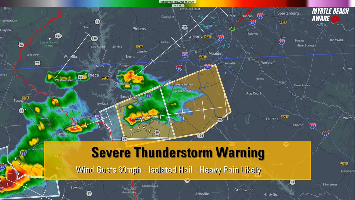
At 330 PM EST, Doppler radar was tracking a strong thunderstorm 8 miles west of Anderson, or near Lake Hartwell, moving east at 20 mph. HAZARD...Wind gusts up to 40 mph and pea size hail. SOURCE...Radar indicated.

BIG TIME Temperature changes out there right now! Are you on the warm side or the cold? Like it or not, Myrtle Beach will be on the cold side very soon! Who is happy about that? #myrwx #SCWeather #scwx

Watching this stronger storm moving through the Manning area towards the Kingstree area soon! I'm ready to go LIVE if any of these go Severe Warned. Stay Aware! #myrwx #SCWeather #scwx

At 235 PM EST, Doppler radar was tracking a strong thunderstorm over Manning, moving east at 20 mph. HAZARD...Wind gusts of 50 to 55 mph and pea size hail. SOURCE...Radar indicated.

We're tracking showers and storms already making their way into the Low-Country and I-95 corridor. Some storms further inland could pack a little punch today. We are ready to go LIVE should anything turn severe. #myrwx #SCWeather #scwx

🌩️ We’re already monitoring the radar as storms develop later today across GA & the Carolinas. Some storms could bring hail & gusty winds. We’re ready to go LIVE anytime if they turn severe! 💙 Venmo: @MyrtleBeachAware PayPal: paypal.me/MyrtleBeachAwa… #SCwx #NCwx #GAwx #SevereWx

⚠️ Storms this afternoon & evening across GA & the Carolinas could bring hail & isolated damaging winds. A brief tornado isn’t ruled out. 🌩️ We’re ready to go LIVE if storms turn severe! 💙 Venmo: @MyrtleBeachAware PayPal: paypal.me/MyrtleBeachAwa… #SCwx #NCwx #SevereWeather


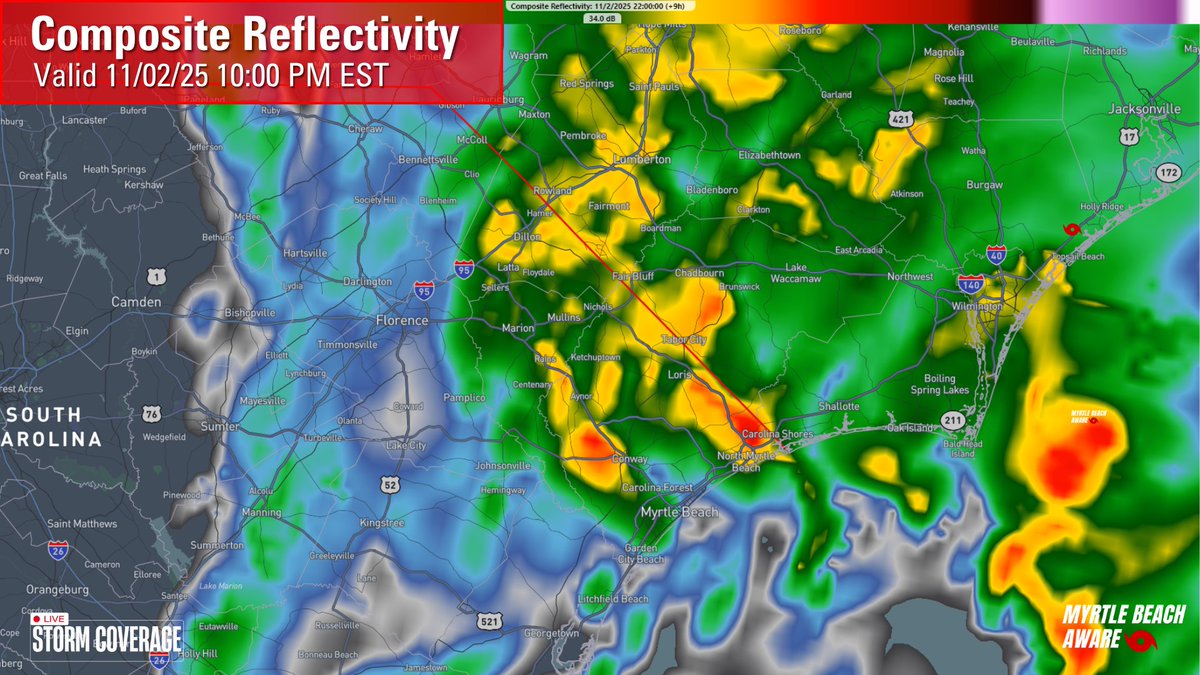
🌧️ Evening Update: Clouds & showers continue tonight as an upper low moves east. A few coastal storms possible. Rain ends early Monday. 🌡️ Lows: 50s | Highs Mon: mid 60s 💨 Breezy NW winds Monday, cooler air moves in. #MyrtleBeach #SCwx #NCwx #WeatherUpdate


United States Trends
- 1. #GrabFoodMegaSalexหลิงออม 249K posts
- 2. Good Thursday 26.1K posts
- 3. SUSDT N/A
- 4. #WorldKindnessDay 8,106 posts
- 5. RIP Brooksie N/A
- 6. Happy Friday Eve N/A
- 7. Rejoice in the Lord 2,086 posts
- 8. PancakeSwap BNB Chain N/A
- 9. Larry Brooks N/A
- 10. #thursdaymotivation 1,736 posts
- 11. #River 5,805 posts
- 12. #SwiftDay N/A
- 13. Namjoon 97.9K posts
- 14. New Zealand 15K posts
- 15. Jokic 30.8K posts
- 16. Michael Burry 6,580 posts
- 17. Eddie Guerrero 3,485 posts
- 18. Mikey 58K posts
- 19. Bill Clinton 42.3K posts
- 20. Horizon 29.1K posts
Something went wrong.
Something went wrong.