#scwx search results

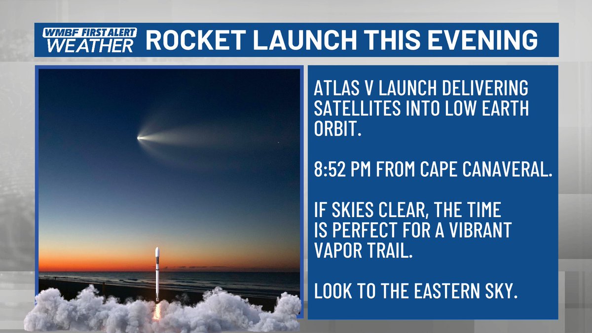
Skies have started to clear out giving us a really good view for the rocket launch this evening to create some really pretty noctilucent clouds. The launch is set for 8:52, look to the east and send us your photos! #scwx @wmbfnews

Rain chances return Tuesday morning. The North Carolina mountains will have the best chance to see rain hold together as well as the best chance to see the highest rainfall amounts. #ncwx #scwx #gawx


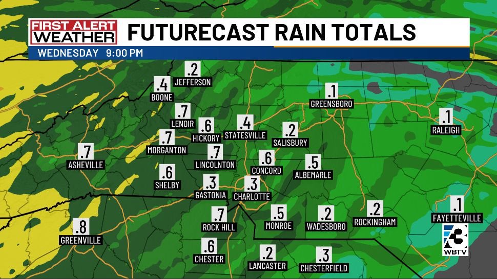
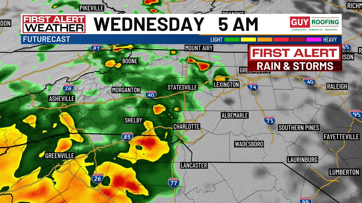
Low-impact showers Tuesday morning, then more significant rain arrives Wednesday morning. Expecting 0.25"-0.5" of rain along & east of I-77, a little more to the west. Outside chance (threat level 1 out of 5) of severe thunderstorm wind gusts. #NCwx #SCwx @WBTV_News


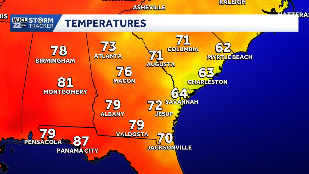
Easy to spot where low clouds are located today. Cooler temps from #Savannah to Myrtle Beach. #gawx #scwx

The pine pollen is down, but still lots of other tree pollen out. The # drought and lack of rain have allowed this pollen to blow around and stick around. The good news is that we are past the peak, and things get better quickly in May. #cltwx #ncwx #scwx #wcnc


Heavy rainfall hit the Carolinas on Sunday, with a marginal severe risk continuing throughout the day. Damaging wind and hail chances stick around into Monday. #SCwx
SNOW ON THE BEACH: 🌴❄️ February kicked off with a rare snow-meets-the-surf scene in Myrtle Beach! 🌊 Parts of the Carolina coast picked up 3–5 inches of snow over the weekend. #SCwx

Cloudy and cooler temps? Thanks northeast winds from an area of low pressure off the east coast! This won't last long though as clouds are already starting to clear out in NC. #scwx #ncwx #gawx

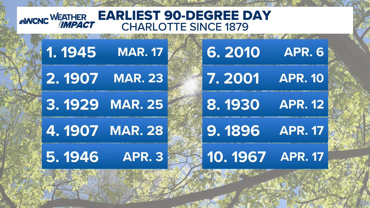
We haven't had a 90° in April since 2010, and this week we could do it 4-5 times, with record highs and the top-ten earliest 90° on record. #cltwx #ncwx #scwx #wcnc


It’s one thing to be too high with a storm outlook or forecast, but to double and triple down on it when there are signs of significant change is a head scratcher to me. #ncwx #scwx #vawx
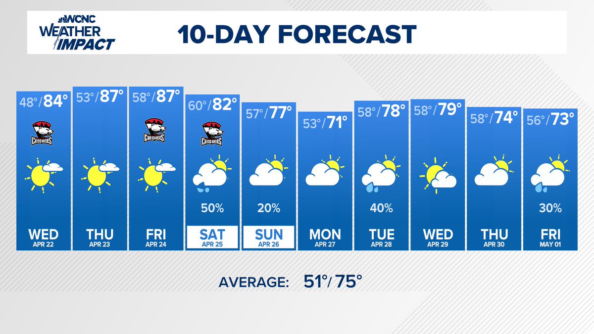
10-Day Forecast: Hot and dry the next 3 days, but signs of a normal pattern for mid to upper 70s and rain chanecs every 2-3 days starting this weekend. #cltwx #ncwx #scwx #wcnc

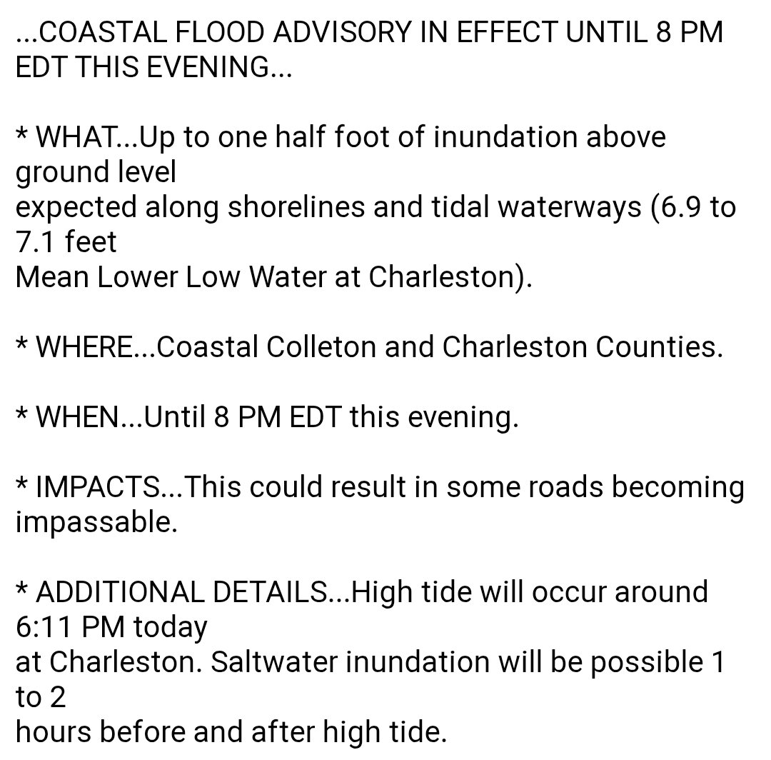
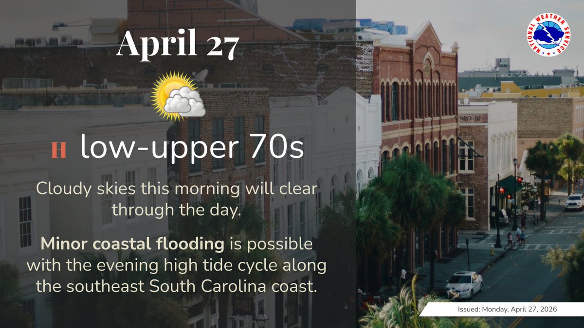
NEW: *Coastal Flood Advisory* for coastal Charleston and Colleton counties until 8 PM. Minor coastal flooding possible. High tide is at 6:11 PM. #scwx

It’s Carolinas Rip Current Awareness Week! Rip currents are the #1 weather related killer in the coastal Carolinas. Follow us throughout the week for rip current and beach safety tips to keep you & your family safe at the beach. Link: weather.gov/ilm/ripcurrents #scwx #ncwx
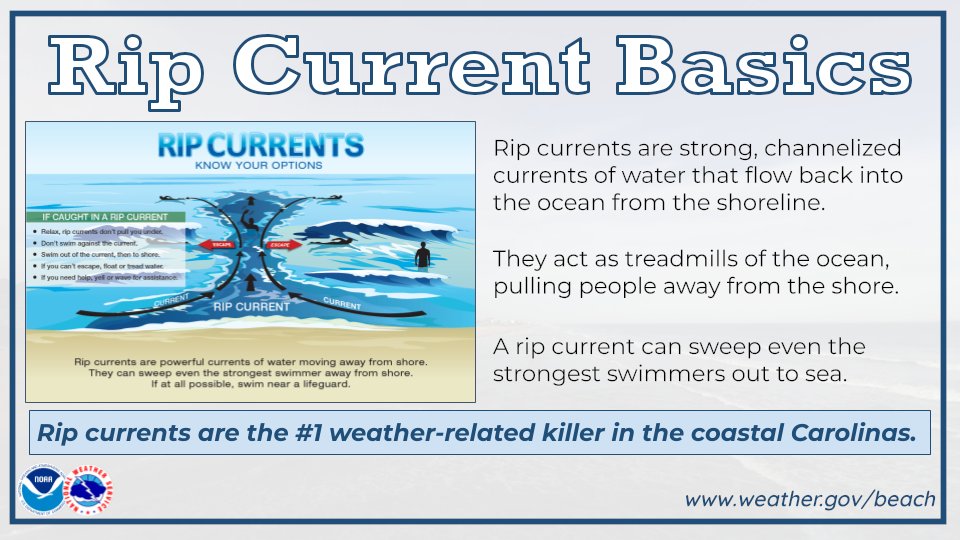
🏄The 2nd Carolinas Rip Current Awareness Week is later this month! Between April 26th & May 22d, NWS offices across the Carolinas will be promoting rip current safety. Everyone can help by force-multiplying the messages and reaching as many people as possible! #scwx


National High/Low temps for Saturday April 11, 2026: 92 at Coolidge, AZ, Phoenix, AZ, 3 miles southeast of Horrel Hill, SC; 15 at 17 miles northwest of Lutsen, MN, 2 miles southeast of Canada Creek Ranch, MI #azwx #azwx #scwx #mnwx #miwx

Good Morning ladies and gents! It's 56 at Second Look Charities Boutique at O:Dark.30. Mostly sunny by afternoon; really nice y'all, today's high 74 🌤️ Clear and cool tonight; low 49 🌙 #SCwx Tuesday 76/60 🌥️ Wednesday 81/59 🌦️ (morning showers) 🙏 Thursday 75/54 ⛅️ (another nice

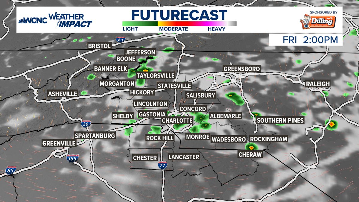
It's not much, but just maybe a few very isolated showers are possible on Friday afternoon. A disturbance over in Tennessee moves over us with maybe just enough to kick off a stray shower or storm, just need some low-level moisture. #cltwx #ncwx #scwx #wcnc

Hey @NWSColumbia check out this dust devil in downtown Camden that was just sent to me by Ashlee Baird over on FB. Taken at E Dekalb St and Lakeshore Dr. #scwx #caewx

Rain chances return Tuesday morning. The North Carolina mountains will have the best chance to see rain hold together as well as the best chance to see the highest rainfall amounts. #ncwx #scwx #gawx
Low-impact showers Tuesday morning, then more significant rain arrives Wednesday morning. Expecting 0.25"-0.5" of rain along & east of I-77, a little more to the west. Outside chance (threat level 1 out of 5) of severe thunderstorm wind gusts. #NCwx #SCwx @WBTV_News
Skies have started to clear out giving us a really good view for the rocket launch this evening to create some really pretty noctilucent clouds. The launch is set for 8:52, look to the east and send us your photos! #scwx @wmbfnews
Easy to spot where low clouds are located today. Cooler temps from #Savannah to Myrtle Beach. #gawx #scwx
It’s Carolinas Rip Current Awareness Week! Rip currents are the #1 weather related killer in the coastal Carolinas. Follow us throughout the week for rip current and beach safety tips to keep you & your family safe at the beach. Link: weather.gov/ilm/ripcurrents #scwx #ncwx
NEW: *Coastal Flood Advisory* for coastal Charleston and Colleton counties until 8 PM. Minor coastal flooding possible. High tide is at 6:11 PM. #scwx

IF skies can clear out and the launch is on time, we will be treated to a fantastic view. The timing of the latest launch of the Atlas V will be close enough to sunset for a vibrant vapor trail. Fingers crossed. So far, it's all systems go for launch. #SCwx @wmbfnews


I gave a presentation at U Arizona last fall, and showed this slide - my 4 signature S Carolina based droughts from historical data shows up well in the tree-ring maps. #scwx #drought

Cloudy and cooler temps? Thanks northeast winds from an area of low pressure off the east coast! This won't last long though as clouds are already starting to clear out in NC. #scwx #ncwx #gawx
Cloudy and cooler temps? Thanks northeast winds from an area of low pressure off the east coast! This won't last long though as clouds are already starting to clear out in NC. #scwx #ncwx #gawx

Cloudy skies this morning will clear through the day. Minor coastal flooding is possible with the evening high tide cycle along the southeast South Carolina coast. #scwx #gawx
Newspaper entry from the Edgefield Advertiser, Oct. 17, 1839, describes one of my South Carolina historical drought events. #scwx #drought


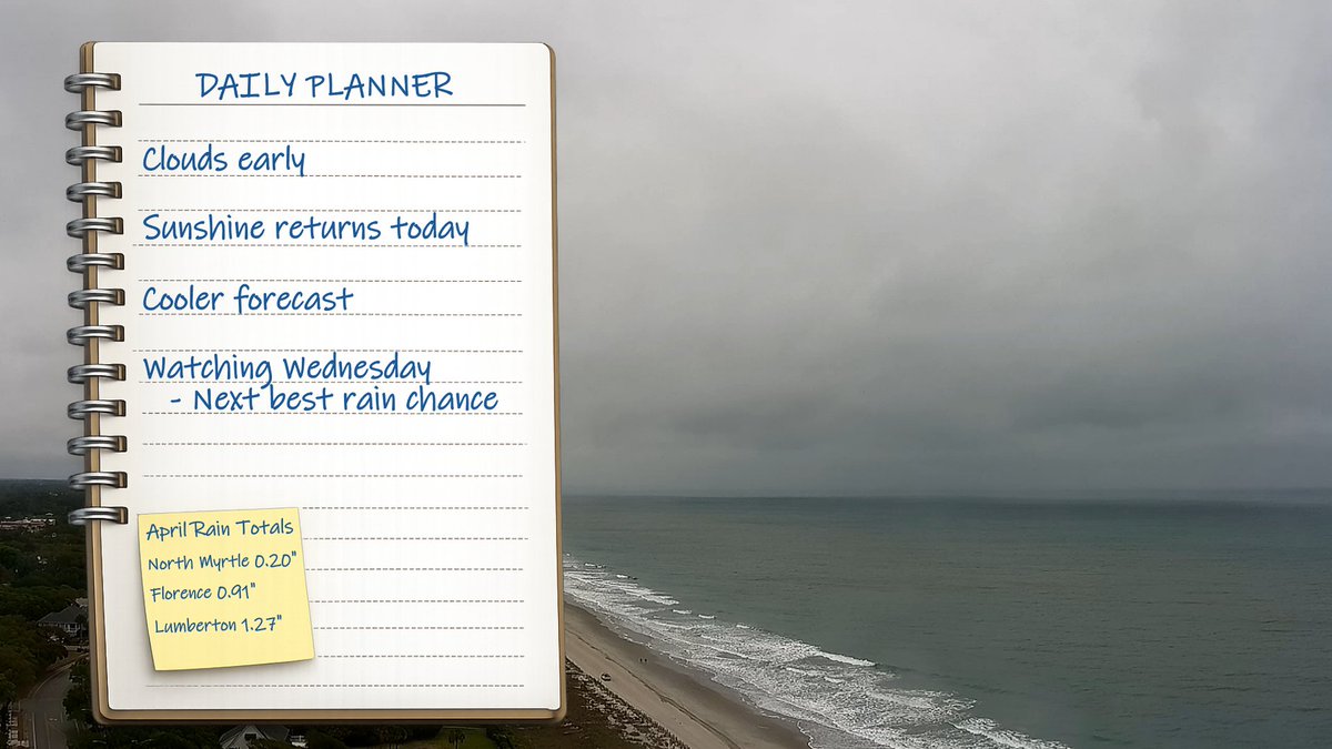
It's cool and cloudy to start the day. Didn't pick up on the rain this weekend? Our next best chance for rain arrives on Wednesday. @wmbfnews @jamiearnoldWMBF #scwx #ncwx #myrwx
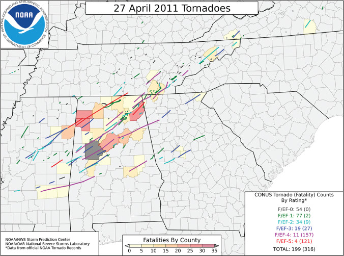
ON THIS DATE, 15 YEARS AGO: An outbreak of tornadoes tore across the southeastern United States with numerous long-track violent tornadoes. The supercell responsible for the tornado that devastated Tuscaloosa, AL. #scwx #gawx #ncwx


• Today: Sunshine, cool start, comfortable finish, 70s • Tuesday: Clouds & sun, small shower chance, 70° • Wednesday: First Alert: Good chance for rain! • Rest of Week: Stays cool, another rain chance Saturday #scwx #cltwx #ncwx #clt
First Alert: Wednesday could bring us our best chance for much-needed rain since Easter. Most of the showers will come to the #CLT area during the AM hours - impacting the commute - but there could be a heavier thunderstorm or 2 as well, even during the PM hours. #scwx #ncwx

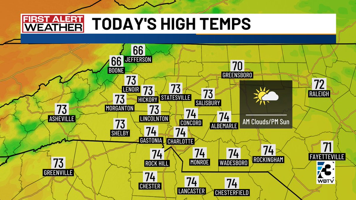
First Alert: Morning clouds around the #CLT region will give way to more sunshine for the rest of the day. Breezy & coolish again today with highs in the 70s for most east of the mountains. #NCwx #SCwx #CLTwx


It’s Carolinas Rip Current Awareness Week! Rip currents are the #1 weather related killer in the coastal Carolinas. Follow us throughout the week for rip current and beach safety tips to keep you & your family safe at the beach. Link: weather.gov/ilm/ripcurrents #scwx #ncwx
Rain chances return Tuesday morning. The North Carolina mountains will have the best chance to see rain hold together as well as the best chance to see the highest rainfall amounts. #ncwx #scwx #gawx
IF skies can clear out and the launch is on time, we will be treated to a fantastic view. The timing of the latest launch of the Atlas V will be close enough to sunset for a vibrant vapor trail. Fingers crossed. So far, it's all systems go for launch. #SCwx @wmbfnews
Cloudy and cooler temps? Thanks northeast winds from an area of low pressure off the east coast! This won't last long though as clouds are already starting to clear out in NC. #scwx #ncwx #gawx
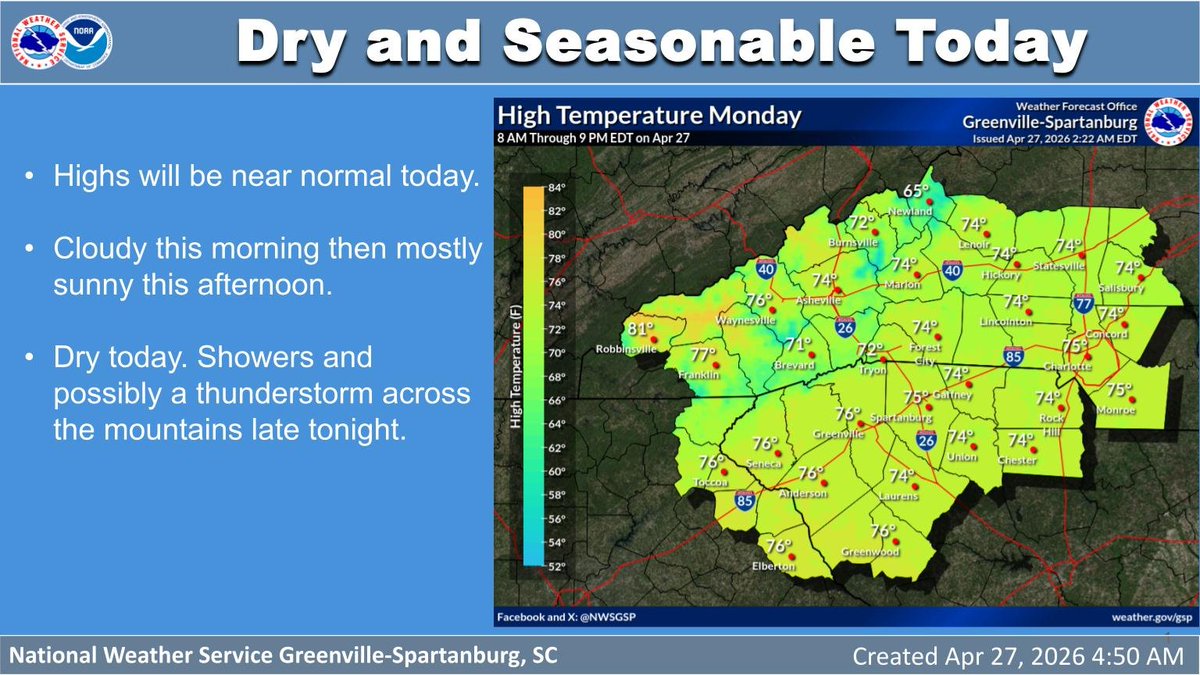
Morning clouds give way to afternoon sunshine. Highs will be near normal. Dry today with showers and isolated storms moving into the mountains late tonight. #ncwx #scwx #gawx
It's cool and cloudy to start the day. Didn't pick up on the rain this weekend? Our next best chance for rain arrives on Wednesday. @wmbfnews @jamiearnoldWMBF #scwx #ncwx #myrwx
ON THIS DATE, 15 YEARS AGO: An outbreak of tornadoes tore across the southeastern United States with numerous long-track violent tornadoes. The supercell responsible for the tornado that devastated Tuscaloosa, AL. #scwx #gawx #ncwx
The pine pollen is down, but still lots of other tree pollen out. The # drought and lack of rain have allowed this pollen to blow around and stick around. The good news is that we are past the peak, and things get better quickly in May. #cltwx #ncwx #scwx #wcnc
The 2nd Carolinas Rip Current Awareness Week is later this month! Between April 26th & May 2nd, NWS offices across the Carolinas will be promoting rip current safety. Everyone can help by force-multiplying the messages and reaching as many people as possible! #scwx #ncwx


OH MY GOSH!! IT'S RAINING!! One lonely thunderstorm has popped up just south of Conway with some heavy rain near and just south of @CCUChanticleers CONGRATS to the winners. #SCwx @wmbfnews


Summer looks to arrive early by the second half of next week. The current forecast has locations in the western Carolinas and northeast Georgia reaching 90°F for afternoon highs. #scwx #ncwx #gawx
It's not much, but just maybe a few very isolated showers are possible on Friday afternoon. A disturbance over in Tennessee moves over us with maybe just enough to kick off a stray shower or storm, just need some low-level moisture. #cltwx #ncwx #scwx #wcnc
Beneficial rainfall returns Saturday ahead of a cold front. However, rainfall amounts will be light and will have a very little impact on the ongoing drought. #ncwx #scwx #gawx

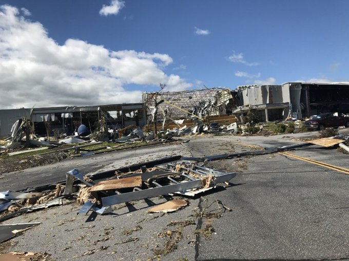
ON THIS DATE, 6 YEARS AGO: An EF3 tornado, one of the strongest in upstate SC history & the strongest to impact the area during the overnight hours, caused major damage & a fatality in the Seneca area. Some data about this event can be found here: ow.ly/ocX250EnfL9 #scwx


Here's a look at the timing of the scattered showers and storms today. Not everyone will see good rain, and even those who do will not amount to a lot. #cltwx #ncwx #scwx #wcnc


Weekend rain chances are highest late Saturday, then it turns much cooler for the end of the weekend. #cltwx #ncwx #scwx #wcnc
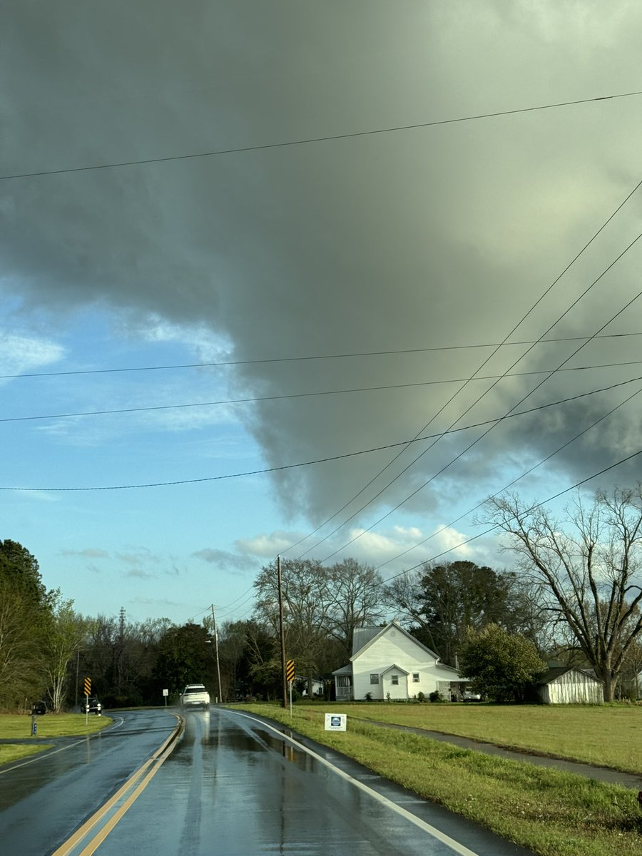
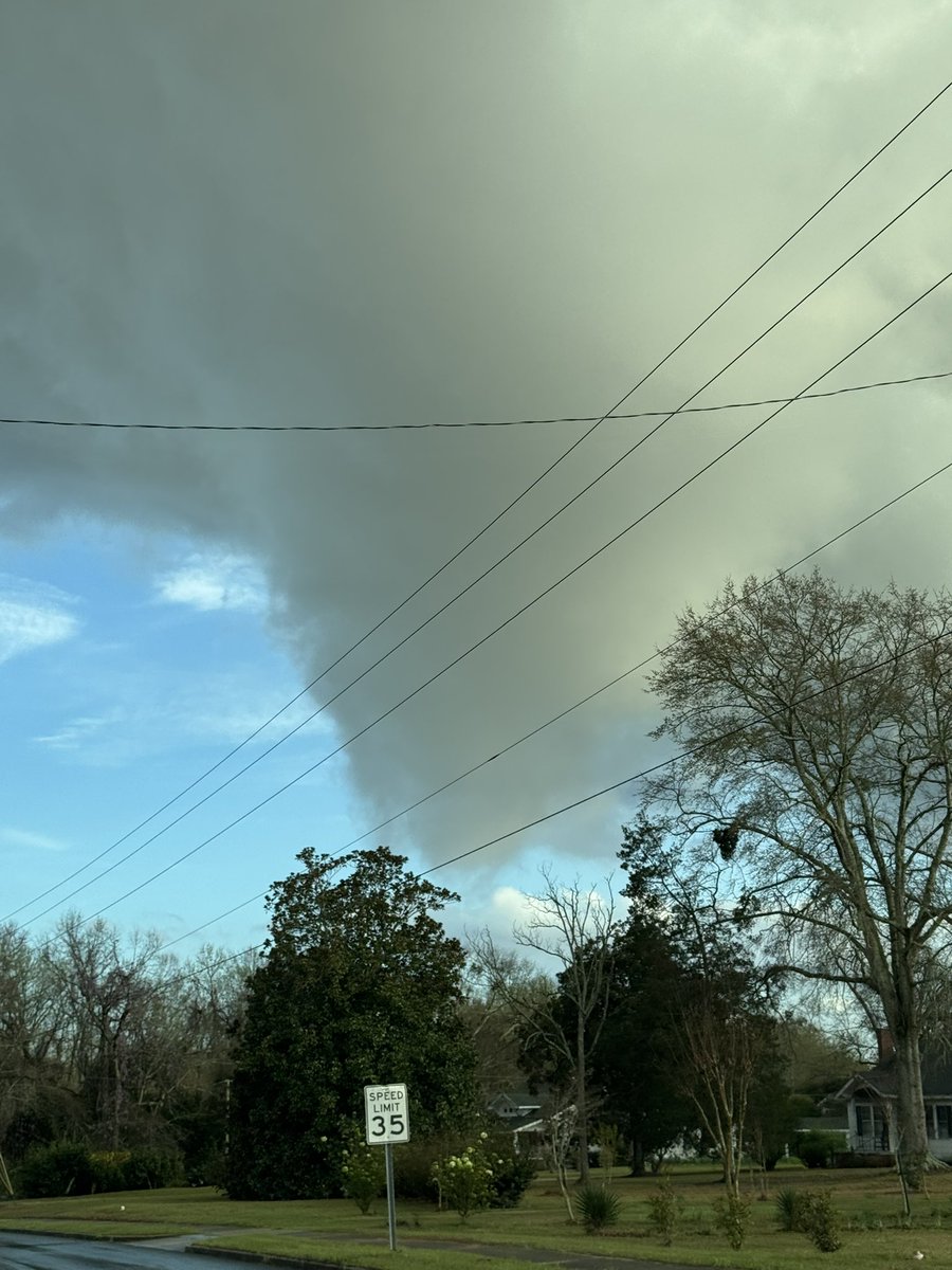
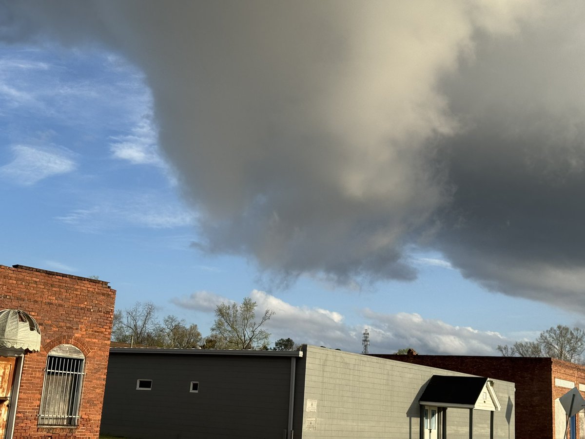
Hey @NWSColumbia here’s a current look at this extraordinarily tiny storm in downtown Swansea. #scwx
Something went wrong.
Something went wrong.
United States Trends
- 1. Kimmel N/A
- 2. Melania N/A
- 3. Sorsby N/A
- 4. Harvey Weinstein N/A
- 5. Amad N/A
- 6. World War Eleven N/A
- 7. Scam Altman N/A
- 8. Sesko N/A
- 9. Aquanet N/A
- 10. Bruno Fernandes N/A
- 11. World War 11 N/A
- 12. Scal N/A
- 13. Gerry Conway N/A
- 14. Frank Isola N/A
- 15. OpenAI N/A
- 16. #MUFC N/A
- 17. Brentford N/A
- 18. Mainoo N/A
- 19. Casemiro N/A
- 20. #StopIllegalFloridaMaps N/A