#scwx search results

SNOW ON THE BEACH: 🌴❄️ February kicked off with a rare snow-meets-the-surf scene in Myrtle Beach! 🌊 Parts of the Carolina coast picked up 3–5 inches of snow over the weekend. #SCwx
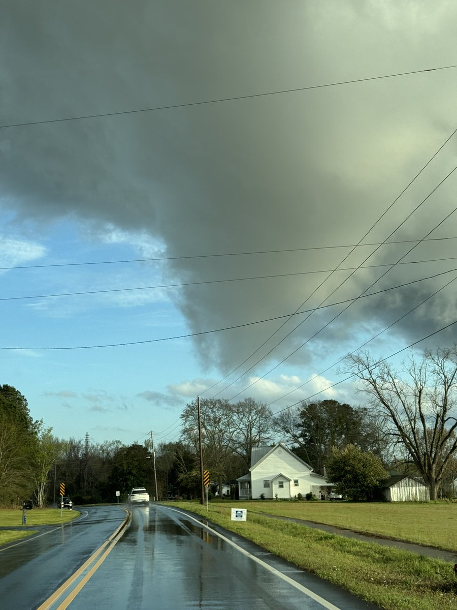
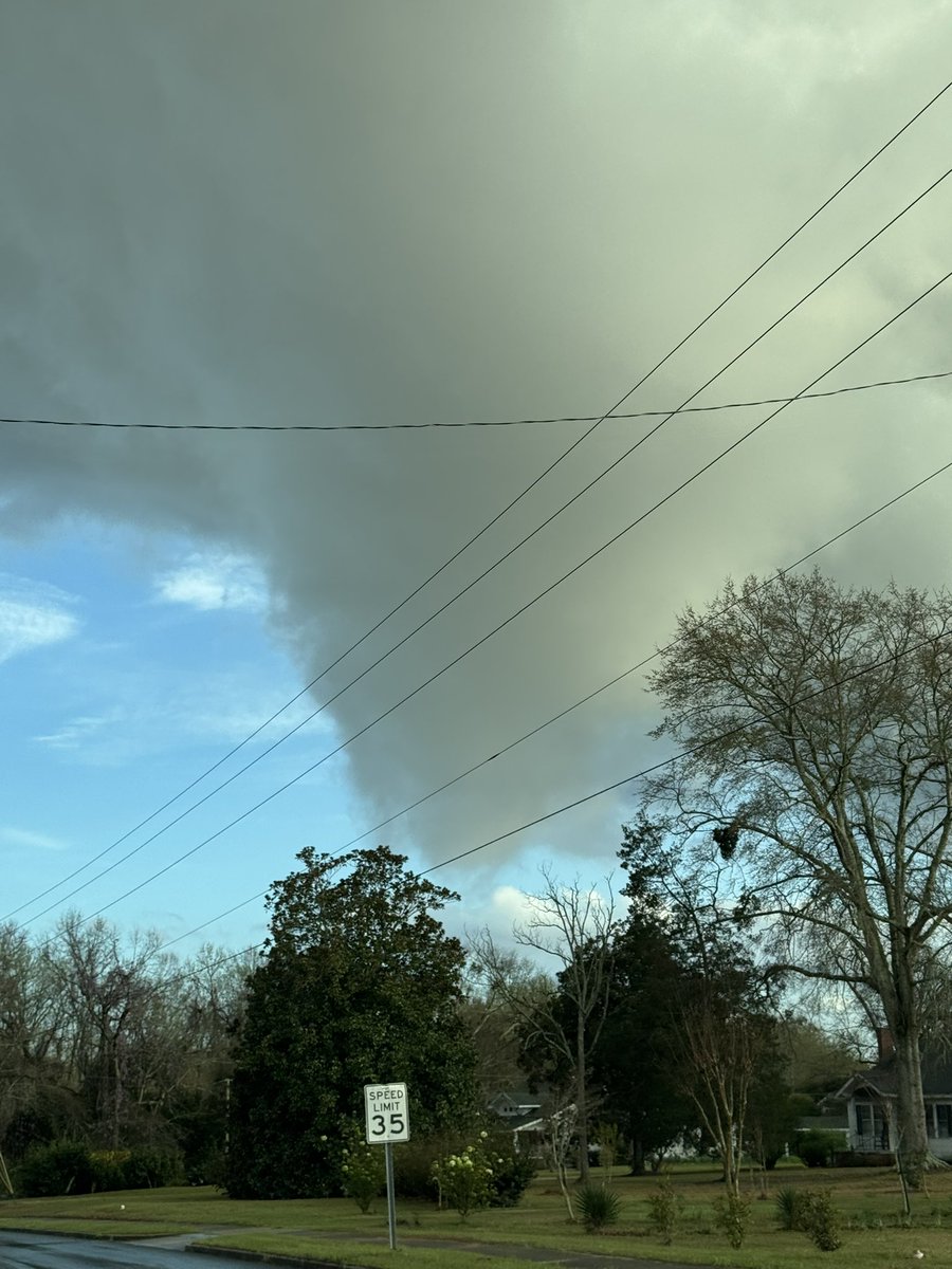
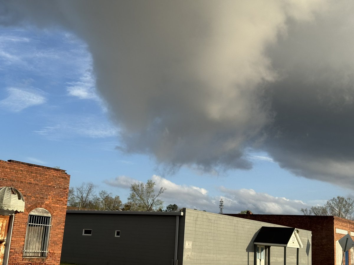
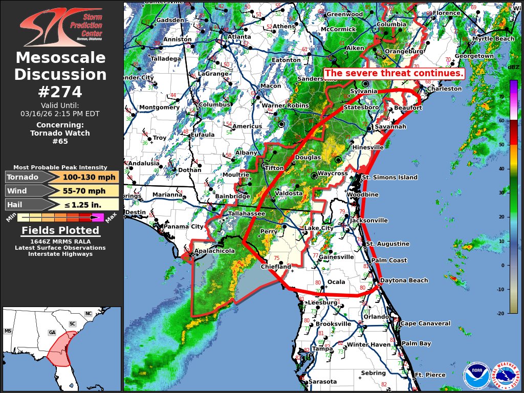
HAPPENING NOW: We're tracking a line of intense storms through the Southeast with embedded tornadoes. A tornado watch continues through 1 pm ET. #GAwx #NCwx #SCwx


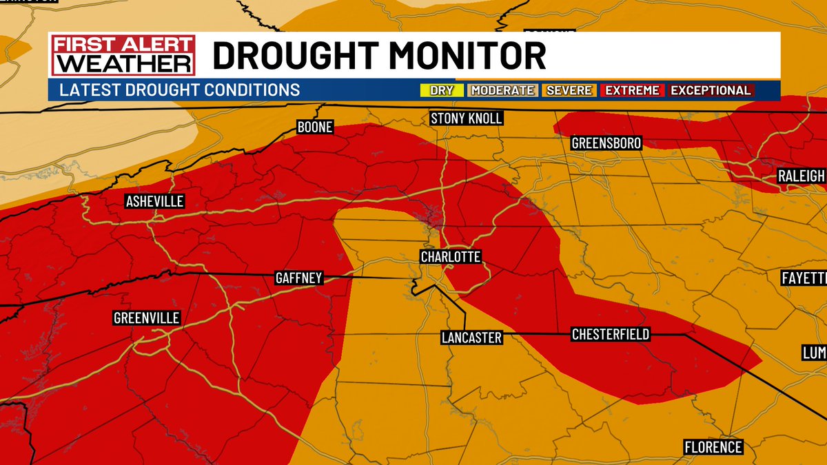
The latest report from the US Drought Monitor just dropped and IT IS UGLY! EXTREME DROUGHT - the second worst category - has expanded across the state including into parts of the Pee Dee. SEVERE DROUGHT now covers 93% of the state - a large jump in just one week. #SCwx #NCwx


Wildfires are caused by a spark in the presence of fuel and oxygen. Strong winds, high temperatures, low humidity and drought conditions can further impact the fire’s spread. To stay ready and protect yourself from wildfires, visit weather.gov/safety/wildfire #scwx #ncwx #gawx


Smoke continues to move into the area from massive wildfires burning in southern Georgia. Expect air quality issues as smoke continues to move in from the south. #scwx @wmbfnews

National High/Low temps for Saturday April 11, 2026: 92 at Coolidge, AZ, Phoenix, AZ, 3 miles southeast of Horrel Hill, SC; 15 at 17 miles northwest of Lutsen, MN, 2 miles southeast of Canada Creek Ranch, MI #azwx #azwx #scwx #mnwx #miwx

Wildfire smoke from the large fires in Georgia and Florida will be moving north and northeast today. Expect poor air quality in parts of the Carolinas today and into the weekend. #cltwx #ncwx #scwx #wcnc

Heavy rainfall hit the Carolinas on Sunday, with a marginal severe risk continuing throughout the day. Damaging wind and hail chances stick around into Monday. #SCwx
National High/Low temps for Saturday April 18, 2026: 97 at 3 miles southeast of Horrel Hill, SC; -10 at Peter Sinks, UT #scwx #utwx go.usa.gov/cu5tP
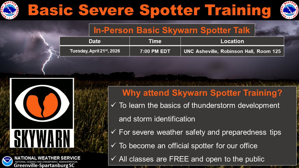
TOMORROW: We will be hosting an in-person Basic Spotter Talk at UNC Asheville tomorrow Tuesday, April 21st at 7 PM EDT. The training will take place in Robinson Hall, Room 125. Please leave a comment below if you have any questions. We hope to see you there! #scwx #ncwx #gawx
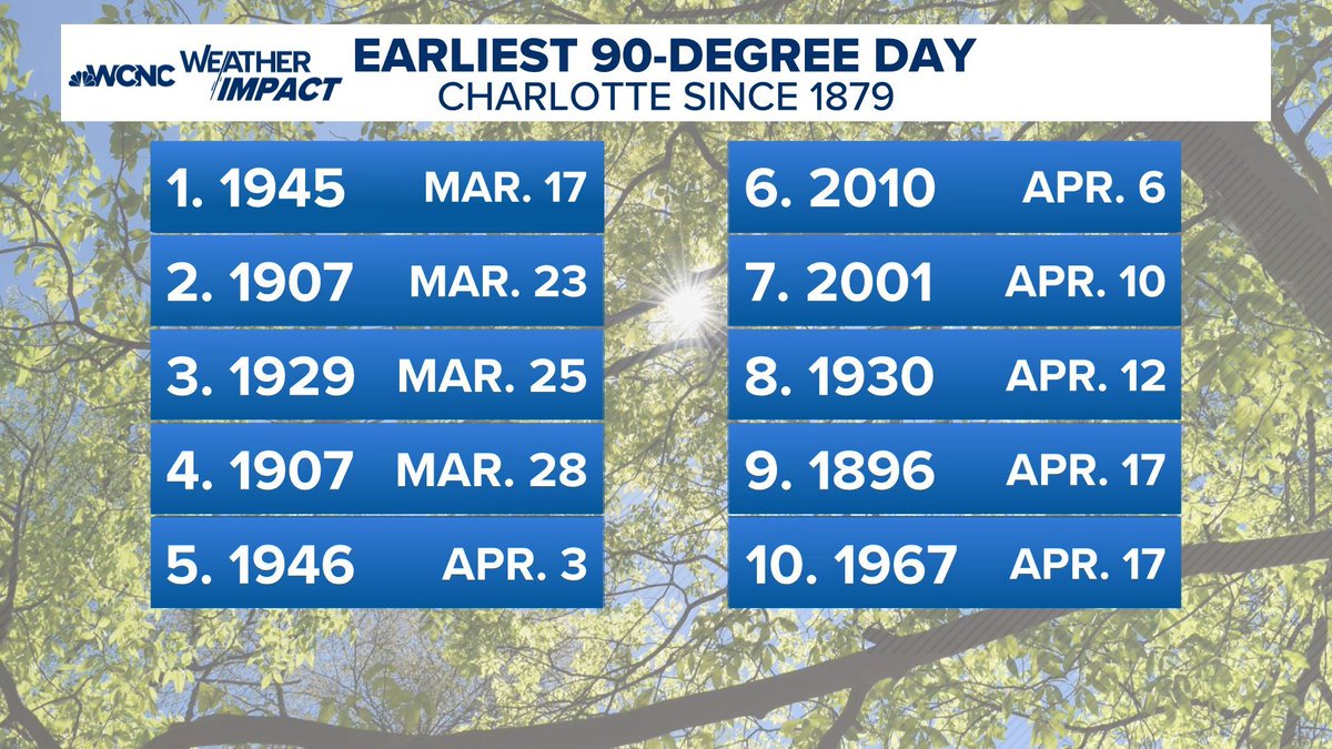
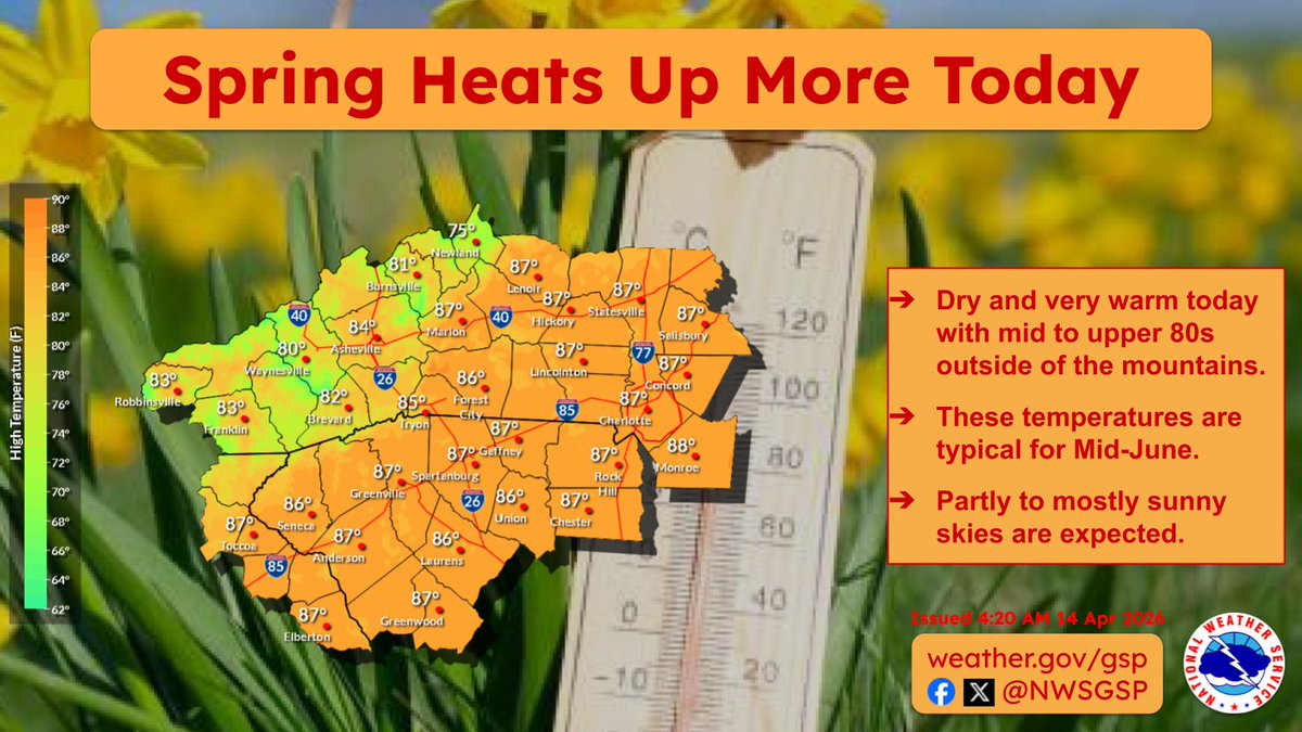
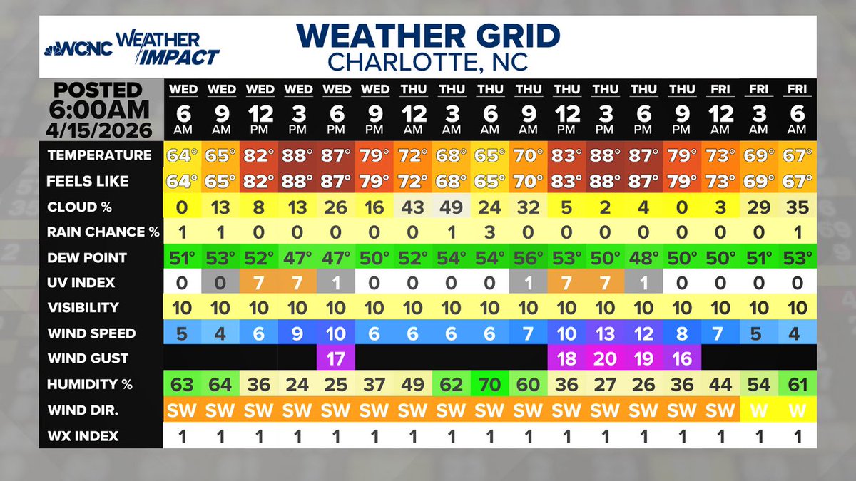
We haven't had a 90° in April since 2010, and this week we could do it 4-5 times, with record highs and the top-ten earliest 90° on record. #cltwx #ncwx #scwx #wcnc


Temperatures this afternoon will feel more like early summer than mid-April. Does anybody have their pool open yet? #scwx #ncwx #gawx
1:14pm ET: The cold front is just now clearing the mountains. Until it passes, there is a chance of scattered showers or thunderstorms. We should see clearing and a nice sunset this evening behind the front. #cltwx #ncwx #scwx #wcnc
Summer looks to arrive early by the second half of next week. The current forecast has locations in the western Carolinas and northeast Georgia reaching 90°F for afternoon highs. #scwx #ncwx #gawx
Dry through Friday with rain chances returning this weekend. However, any drought relief should remain limited as only light rainfall amounts are expected. For now it appears that most locations will see around half an inch or less of rainfall this weekend. #ncwx #scwx #gawx

I think we all kinda how this story ends. What’s the quickest and easiest way to get 8 inches of rain in a month ? 😳🌀 #SCwx @wmbfnews

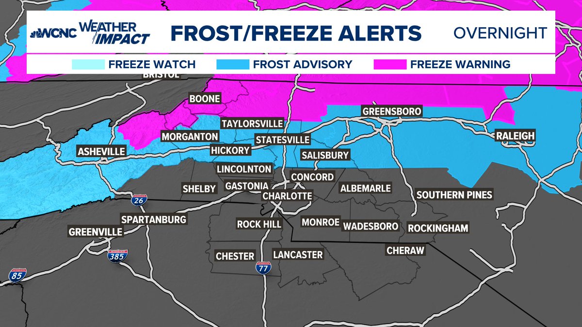
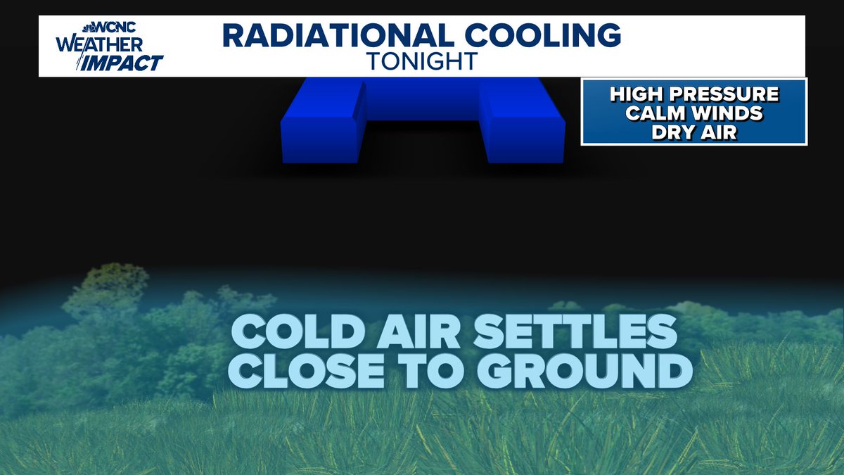
Perfect set-up tonight for Patcy Frost. Chilly start to Tuesday with lows in the mid to upper 30s. #cltwx #ncwx #scwx #wcnc

10-Day Forecast: Hot and dry with little to no rainfall, but a big cool down for Sunday into early next week for a few days. #cltwx #ncwx #scwx #wcnc

Smoke continues to move into the area from massive wildfires burning in southern Georgia. Expect air quality issues as smoke continues to move in from the south. #scwx @wmbfnews

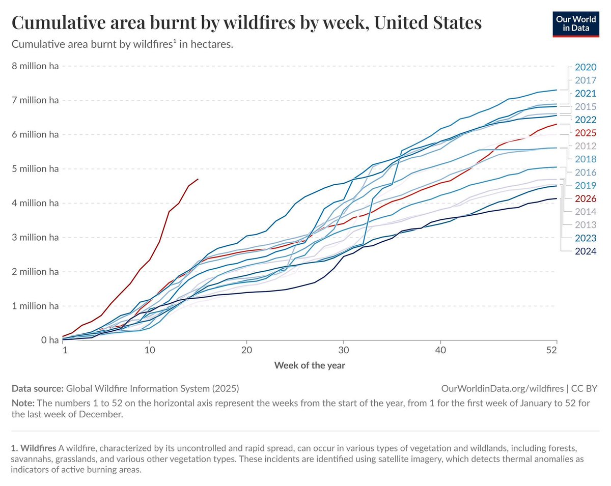
🔥HISTORIC START TO WILDFIRE SEASON🔥 Data provided through @OurWorldInData shows the stark contrast of this year's #Wildfire season compared to the last decade and more, with a notable outpacing of all years in the data set! Analysis below 🔽🔽 #SCWX #GAWX #FLWX @Live5Weather
The pattern finally changes this weekend into early next week as a cold front brings rain chances back on Saturday as well as cooler temperatures this weekend into Monday. #ncwx #scwx #gawx


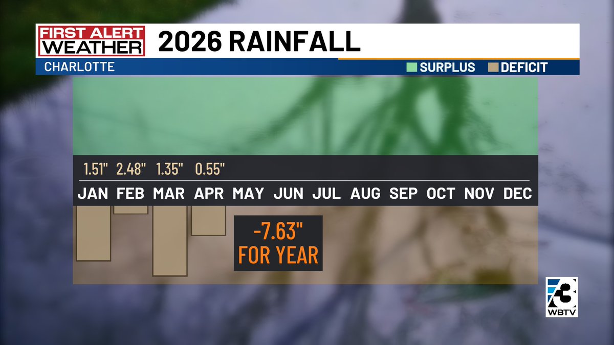
As expected, extreme #drought has expanded across the #CLT region per the updated Drought Monitor & now covers about 40% of the Carolinas. As of today, CLT is down 7.63" of rainfall, YTD, but the current drought extends back to Labor Day. We ended 2025 down 8". #scwx #ncwx #cltwx

Lots of smoke showing up on visible satellite…especially west of I-95 in Southeast Georgia. #gawx #scwx

Wildfire smoke from the large fires in Georgia and Florida will be moving north and northeast today. Expect poor air quality in parts of the Carolinas today and into the weekend. #cltwx #ncwx #scwx #wcnc
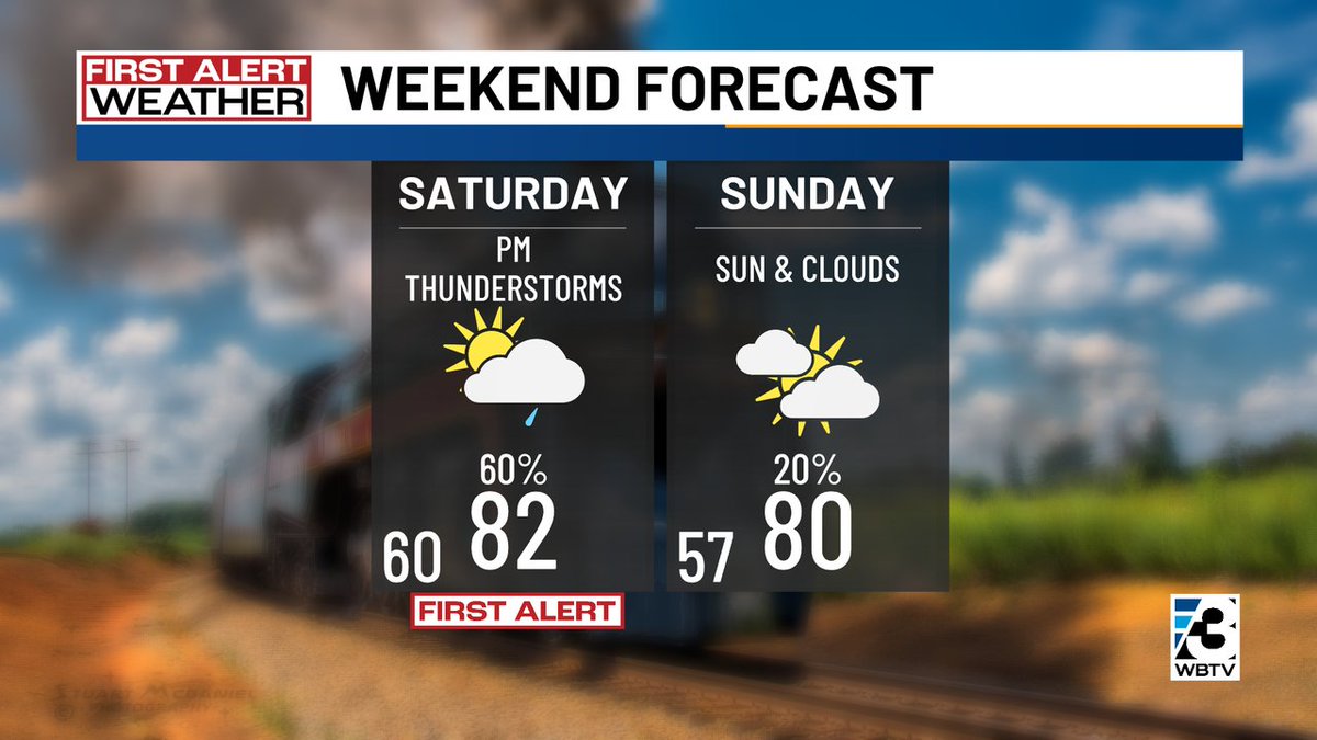
Plenty of sunshine & warm around #CLT the next 2 days with highs in the mid 80s. Saturday brings a chance a couple of PM thundershowers with highs in the lower 80s. Sunday looks dry with a mix of sun & clouds & highs near 80°. #scwx #ncwx #cltwx
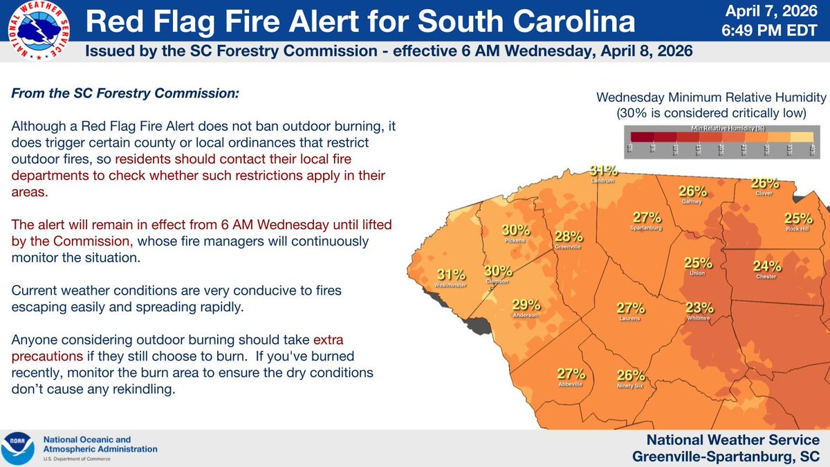
Increased Fire Danger across northeast Georgia due to low relative humidity and very dry vegetation. #gawx Burn bans remain in effect across the Carolinas until further notice, thus outdoor burning is prohibited. #ncwx #scwx


A new First Alert is up for Saturday. A cool front will approach Saturday, prompting scattered showers & storms, mainly during the PM hours. The rain coverage may not be widespread or all that heavy, but could impact your outdoor plans. #CLT #NCwx #SCwx #CLTwx
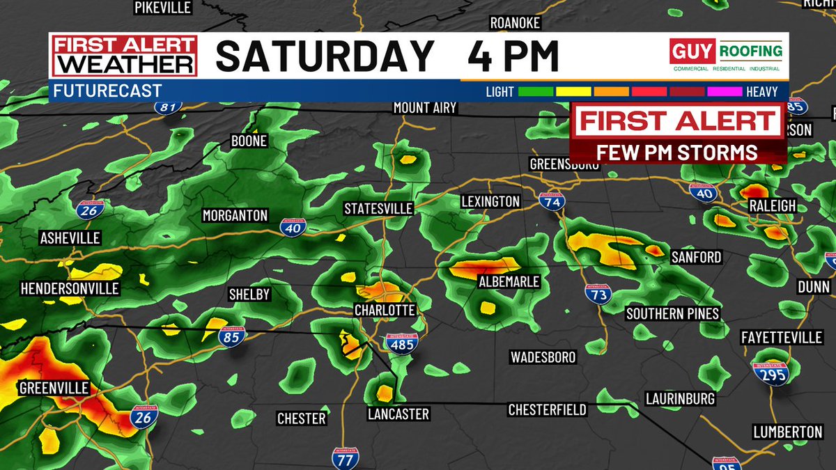
A new First Alert is up for Saturday, as a cool front will pop off a few showers & thunderstorms. Maybe not a lot of rain, but we'll take it! Sunday looks dry & still warm with highs in the upper 70s to near 80°. #NCwx #SCwx #CLTwx

First Alert: Down almost 8 inches YTD in #CLT, it would be awesome to get a good soaking rain, but at this point, we'll take what we can get! Generally no more than a quarter inch east of the mountains Saturday PM. Little more expected in the High Country. #NCwx #SCwx #CLTwx

Sunshine & pleasantly warm today around the #CLT region with highs in the middle 80s in most neighborhoods east of the mountains. #NCwx #SCwx #CLTwx

First Alert: Sunshine & warm afternoon temps around #CLT today & Friday before scattered PM thunderstorms pop up on Saturday. Another rain chance may develop Monday night into Tuesday. #NCwx #SCwx #CLTwx


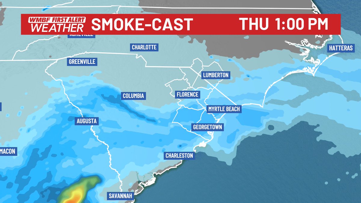
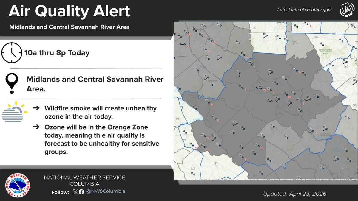
Air Quality Alert remains in effect for South Carolina until Thursday evening as wildfire smoke continues to create hazy skies and unhealthy air for sensitive groups. Limit outdoor activity if smoke is present. #SCwx #AirQualityAlert

Southerly winds on the west side of high pressure centered just off the Southeast coast will continue to transport smoke from the southern Georgia wildfires into South Carolina today. #scwx
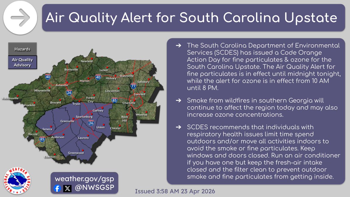
Expect plenty of smoky skies and a haze today smoke moves northeast from the ongoing wildfires in Georgia. An Air Quality Alert is out for today. Those with respiratory issues or chronic illnesses are encouraged to remain indoors when the smoke is thick. #scwx #gawx @wmbfnews


The latest report from the US Drought Monitor just dropped and IT IS UGLY! EXTREME DROUGHT - the second worst category - has expanded across the state including into parts of the Pee Dee. SEVERE DROUGHT now covers 93% of the state - a large jump in just one week. #SCwx #NCwx
10-Day Forecast: Hot and dry with little to no rainfall, but a big cool down for Sunday into early next week for a few days. #cltwx #ncwx #scwx #wcnc

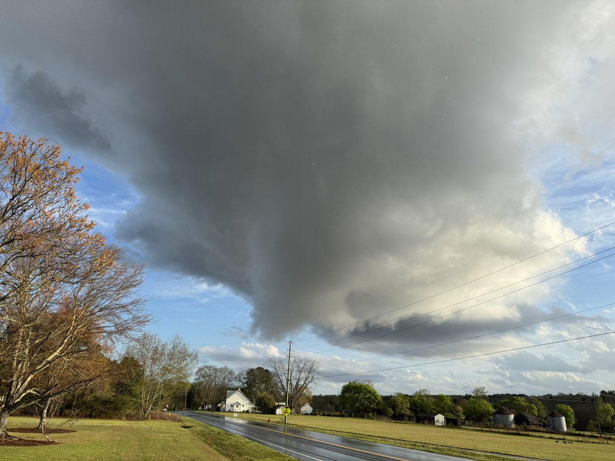
Hey @NWSColumbia here’s a current look at this extraordinarily tiny storm in downtown Swansea. #scwx


10-Day Forecast: Hot and dry the next 3 days, but signs of a normal pattern for mid to upper 70s and rain chanecs every 2-3 days starting this weekend. #cltwx #ncwx #scwx #wcnc
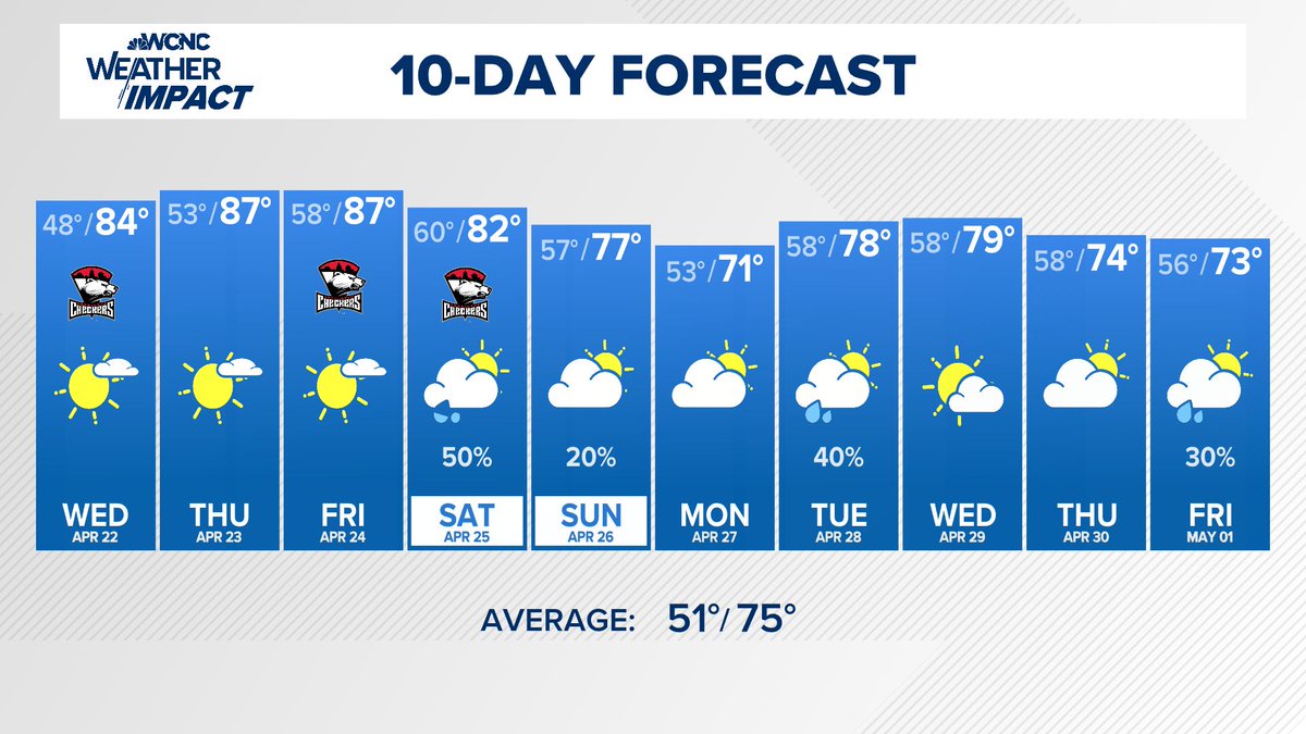

10-Day Forecast: Hot and dry until the weekend, and then more chances of rain next week, finally. #cltwx #ncwx #scwx #wcnc

We haven't had a 90° in April since 2010, and this week we could do it 4-5 times, with record highs and the top-ten earliest 90° on record. #cltwx #ncwx #scwx #wcnc
Wildfire smoke from the large fires in Georgia and Florida will be moving north and northeast today. Expect poor air quality in parts of the Carolinas today and into the weekend. #cltwx #ncwx #scwx #wcnc


ON THIS DATE, 106 YEARS AGO: A tornado touched down in Oconee County, SC, near Westminster. 10 people were injured. An F4 tornado touched down in Union County, NC, near Monroe, and tracked 32 miles to Norwood in Stanly County, killing 3 people and injuring 20 more. #scwx #ncwx

A new First Alert is up for Saturday, as a cool front will pop off a few showers & thunderstorms. Maybe not a lot of rain, but we'll take it! Sunday looks dry & still warm with highs in the upper 70s to near 80°. #NCwx #SCwx #CLTwx
HAPPENING NOW: We're tracking a line of intense storms through the Southeast with embedded tornadoes. A tornado watch continues through 1 pm ET. #GAwx #NCwx #SCwx
SC Forestry Commission issued a statewide Red Flag Fire Alert, effective 6 AM Wed until further notice. It was issued to strongly discourage outdoor burning as weather conditions present an elevated risk of wildfire. For more information visit scfc.gov. #scwx
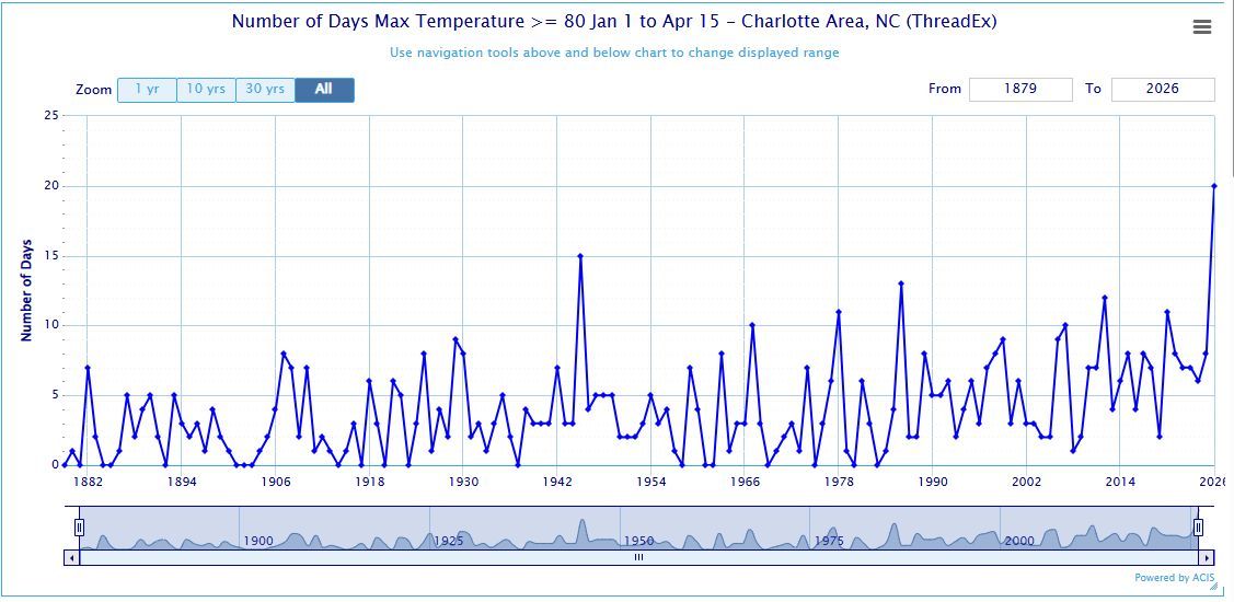
80° days in Charlotte to start the year through April 15th. 20 Days!!! That's 5 more than the previous record. #cltwx #ncwx #scwx #wcnc
Pouring over the latest data this morning...the only real chance for at least some rain doesn't look to arrive until the END OF THE MONTH. #SCwx @wmbfnews

The summer-like temperatures and dry weather will continue today. If your pool is ready to go, definitely do a cannon ball for us! #scwx #ncwx #gawx

Something went wrong.
Something went wrong.
United States Trends
- 1. Draft Day N/A
- 2. Vrabel N/A
- 3. Good Thursday N/A
- 4. #PhinsUp N/A
- 5. Happy Friday Eve N/A
- 6. Caleb Downs N/A
- 7. Schedule III N/A
- 8. Counseling N/A
- 9. AIIocation N/A
- 10. James Pearce Jr. N/A
- 11. #VenezuelaVuelaLibre N/A
- 12. #WorldBookDay N/A
- 13. Halo N/A
- 14. Rickea Jackson N/A
- 15. #ThursdayThoughts N/A
- 16. #thursdayvibes N/A
- 17. Thirsty Thursday N/A
- 18. Paramount Skydance N/A
- 19. Reza Pahlavi N/A
- 20. Molly Ringworm N/A