#datacapturefriday search results

#DataCaptureFriday is back and this week and we're sharing a beautiful 3D fly-through of the City of Ruse in Bulgaria, provided courtesy of our friends at Geographica Ltd. The team flew 8 flights with an #eBeeX & RTK to cover 34 sq. km. with an accuracy of 7 cm. #landsurveying
🇮🇪 Finish your week strong with this point cloud flythrough video of an Irish quarry. The data was captured with a senseFly eBee mapping drone and processed using @pix4d's Pix4Dmapper software. #DataCaptureFriday #drones #dronemapping
digital survey AG, a Swiss surveying partner, sums up a journey in the field in 30 seconds. From the flight with the #eBeeX drone with RTK to the outputs generated. Enjoy this #DataCaptureFriday! #photogrammetry @AgEagleUAVS
It’s the end of the week and you know what that means—another #DataCaptureFriday video for you to enjoy! Watch this 3D flythrough point cloud of the UAE’s Hatta Dam, courtesy of our friends at @AngellSurveys. #dronemapping #eBee #drones
This week's #DataCaptureFriday post comes from Mohamed Znaina who recently mapped a 600Ha quarry in Agadir, #Morocco. The eBee X is an essential part of his #surveying toolkit and offers the flexibility to take on any project. #etafat #Mining
In today’s #DataCaptureFriday post, you’ll get a close look at the Al-Hajar Mountains which feed the turquoise waters of the Hatta Dam near Dubai. This dataset was captured by @feds_ae using an eBee Plus & #eBeeX fixed-wing #drones paired with our S.O.D.A. cameras. @AgEagleUAVS
This week’s #DataCaptureFriday takes us to Kicevo, North Macedonia. Roam this 18.3-kilometer stretch of highway mapped with an eBee Plus RTK and senseFly S.O.D.A. camera. Learn more about the S.O.D.A. camera here: sensefly.com/camera/sensefl… #drones #mapping #photogrammetry
How are #drones beneficial for environmental surveys in sites with large elevation changes? bit.ly/3As9Xgv This week #DataCaptureFriday is part of the senseFly & @pix4d Photogrammetry Awards highlights. #dronesurvey #environmentalsurvey #senseFly #eBeeX @AgEagleUAVS
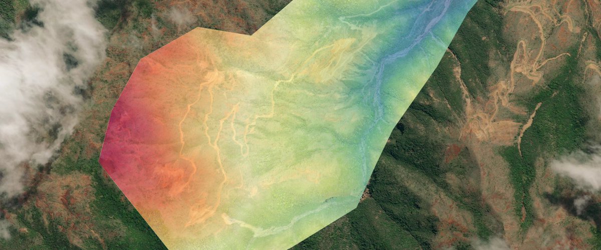
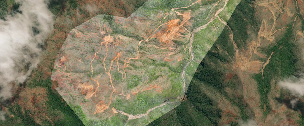
How are #drones used for landslide assessment where accuracy is crucial? Find the answer here: sensefly.com/blog/landslide… This week #DataCaptureFriday is part of the senseFly & @pix4d Photogrammetry Awards highlights! #dronemapping #disastermanagement

AgFunder: RT @sensefly: It’s another #DataCaptureFriday! This week’s video comes from the UAE. Explore the Hatta Mountains with this 3D point cloud by @AngellSurveys using an #eBeePlus and senseFly S.O.D.A. sensor. Learn more about this #photogrammetry…
Today’s #DataCaptureFriday shows a thermal view of the Sheep River in Canada. For this #BVLOS project, our partner IN•FLIGHT Data captured 8 km / 4.9 mi of flood data for #disasterpreparedness with an #eBeeX UAS and Duet T. Webinar: bit.ly/3PdSw9D @AgEagleUAVS
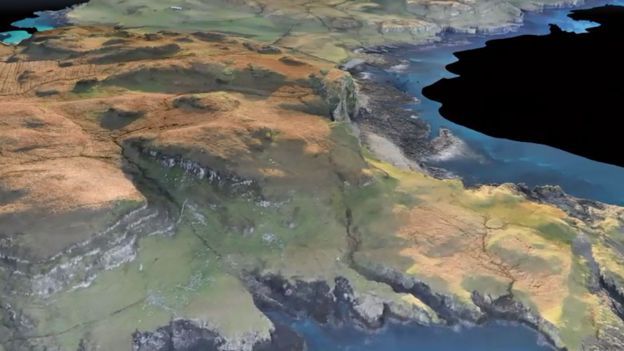
This week's #DataCaptureFriday is hard to top! @paulsmind conducted an eBee #dronesurvey of Canna & Sanday Islands and collected 420 million data points, creating what may be the world's most detailed 3D map of islands yet. zcu.io/bS4P #drones #mapping #archaeology
Which one do you use the most, RTK or PPK? In today's #DataCaptureFriday the Drones Pacifique Services team opted for #PPK to map a former open-pit mine with the #eBeeX and S.O.D.A. 3D. Link to the #dataset —DSM and orthomosaic— here: bit.ly/3DUCBbP @AgEagleUAVS #UAS
Today's #DataCaptureFriday showcases a mapping mission over the Thio #mining center of #NewCaledonia. Drones Pacifique Services flew an #eBeeX & S.O.D.A. 3D to map a 320 ha / 790 ac former open-pit mine for soil restoration planning. bit.ly/3xbv7PX
Last year the @DroneAdventures team mapped Glacier d'Orny, in the Swiss Alps. As part of our #DataCaptureFriday series, you can visit the 3,271 m (10,732 ft) elev. glacier for yourself in this stunning 3D model - the spaghetti is totally optional!🍝bit.ly/3iFdX4c #drone

Feliz #DataCaptureFriday ! El video de esta semana fue capturado por Geographica usando un eBee Classic. Explore este modelo 3D de una cantera de minerales industriales en el noreste de Bulgaria. Obtenga más información sobre cómo #drones puede beneficiar al #mining industria
Happy #DataCaptureFriday! This week’s video was captured by Geographica using an eBee Classic. Explore this 3D model of an industrial mineral quarry in Northeast Bulgaria. Learn more about how our #drones can benefit the #mining industry: ow.ly/Ki0V50A5mmf.
Today's #DataCaptureFriday flies us through one of the Geographica Ltd. projects to develop #floodrisk and hazard maps with DTM, DSM & ortho data. The team flew over the Bulgarian city of Veliko Tarnovo and the Yantra River with #eBeeX + S.O.D.A. #photogrammetry @AgEagleUAVS
The gravity dam in Salanfe, Switzerland has a storage capacity of 40 million cubic meters. Its massive structure is 52 m high, 40 m wide at the base & 608 m long on top. This #DataCaptureFriday was collected with an #eBeeX carrying a S.O.D.A. 3D camera. bit.ly/3K8a2du
Launch into your weekend with this #DataCaptureFriday video of the eBee X, expertly side launched into the wild blue by our very own @troy_hittle! bit.ly/33TSuPz #drone #photogrammetry #mapping
youtube.com
YouTube
#DataCaptureFriday - eBee X Side Launch
#Aerialmapping of remote island territories comes with many challenges from mountainous terrain to strong winds and unpredictable weather. Read how the eBee X with RTK and @pix4d provided a clear advantage to #landsurveyors & local government authorities. #DataCaptureFriday

🏝️ Mapping in the middle of the atlantic! The Faroe Islands are far away from mainland Europe, and need to be mapped to track development. Umhvørvisstovan use @sensefly drones to map the islands, working with #Pix4Dmatic to gather huge datasets! hubs.li/H0HBCtH0

Today’s #DataCaptureFriday shows a thermal view of the Sheep River in Canada. For this #BVLOS project, our partner IN•FLIGHT Data captured 8 km / 4.9 mi of flood data for #disasterpreparedness with an #eBeeX UAS and Duet T. Webinar: bit.ly/3PdSw9D @AgEagleUAVS
Today's #DataCaptureFriday showcases a mapping mission over the Thio #mining center of #NewCaledonia. Drones Pacifique Services flew an #eBeeX & S.O.D.A. 3D to map a 320 ha / 790 ac former open-pit mine for soil restoration planning. bit.ly/3xbv7PX
Today's #DataCaptureFriday flies us through one of the Geographica Ltd. projects to develop #floodrisk and hazard maps with DTM, DSM & ortho data. The team flew over the Bulgarian city of Veliko Tarnovo and the Yantra River with #eBeeX + S.O.D.A. #photogrammetry @AgEagleUAVS
In today’s #DataCaptureFriday post, you’ll get a close look at the Al-Hajar Mountains which feed the turquoise waters of the Hatta Dam near Dubai. This dataset was captured by @feds_ae using an eBee Plus & #eBeeX fixed-wing #drones paired with our S.O.D.A. cameras. @AgEagleUAVS
Which one do you use the most, RTK or PPK? In today's #DataCaptureFriday the Drones Pacifique Services team opted for #PPK to map a former open-pit mine with the #eBeeX and S.O.D.A. 3D. Link to the #dataset —DSM and orthomosaic— here: bit.ly/3DUCBbP @AgEagleUAVS #UAS
The gravity dam in Salanfe, Switzerland has a storage capacity of 40 million cubic meters. Its massive structure is 52 m high, 40 m wide at the base & 608 m long on top. This #DataCaptureFriday was collected with an #eBeeX carrying a S.O.D.A. 3D camera. bit.ly/3K8a2du
How are #drones beneficial for environmental surveys in sites with large elevation changes? bit.ly/3As9Xgv This week #DataCaptureFriday is part of the senseFly & @pix4d Photogrammetry Awards highlights. #dronesurvey #environmentalsurvey #senseFly #eBeeX @AgEagleUAVS
digital survey AG, a Swiss surveying partner, sums up a journey in the field in 30 seconds. From the flight with the #eBeeX drone with RTK to the outputs generated. Enjoy this #DataCaptureFriday! #photogrammetry @AgEagleUAVS
How are #drones used for landslide assessment where accuracy is crucial? Find the answer here: sensefly.com/blog/landslide… This week #DataCaptureFriday is part of the senseFly & @pix4d Photogrammetry Awards highlights! #dronemapping #disastermanagement
This week's #DataCaptureFriday comes from Bolivia! Check out the different #topography outputs - orthomosaics, 3D models, contour lines, point clouds and NDVI - that @TerratecSRL generates with the #eBeeX drone and its interchangeable cameras. bit.ly/2YKwJlu
This week's #DataCaptureFriday is hard to top! @paulsmind conducted an eBee #dronesurvey of Canna & Sanday Islands and collected 420 million data points, creating what may be the world's most detailed 3D map of islands yet. zcu.io/bS4P #drones #mapping #archaeology
#Aerialmapping of remote island territories comes with many challenges from mountainous terrain to strong winds and unpredictable weather. Read how the eBee X with RTK and @pix4d provided a clear advantage to #landsurveyors & local government authorities. #DataCaptureFriday
🏝️ Mapping in the middle of the atlantic! The Faroe Islands are far away from mainland Europe, and need to be mapped to track development. Umhvørvisstovan use @sensefly drones to map the islands, working with #Pix4Dmatic to gather huge datasets! hubs.li/H0HBCtH0
This week's #DataCaptureFriday post comes from Mohamed Znaina who recently mapped a 600Ha quarry in Agadir, #Morocco. The eBee X is an essential part of his #surveying toolkit and offers the flexibility to take on any project. #etafat #Mining
Last year the @DroneAdventures team mapped Glacier d'Orny, in the Swiss Alps. As part of our #DataCaptureFriday series, you can visit the 3,271 m (10,732 ft) elev. glacier for yourself in this stunning 3D model - the spaghetti is totally optional!🍝bit.ly/3iFdX4c #drone
#DataCaptureFriday is back and this week and we're sharing a beautiful 3D fly-through of the City of Ruse in Bulgaria, provided courtesy of our friends at Geographica Ltd. The team flew 8 flights with an #eBeeX & RTK to cover 34 sq. km. with an accuracy of 7 cm. #landsurveying
Launch into your weekend with this #DataCaptureFriday video of the eBee X, expertly side launched into the wild blue by our very own @troy_hittle! bit.ly/33TSuPz #drone #photogrammetry #mapping
youtube.com
YouTube
#DataCaptureFriday - eBee X Side Launch
Feliz #DataCaptureFriday ! El video de esta semana fue capturado por Geographica usando un eBee Classic. Explore este modelo 3D de una cantera de minerales industriales en el noreste de Bulgaria. Obtenga más información sobre cómo #drones puede beneficiar al #mining industria
Happy #DataCaptureFriday! This week’s video was captured by Geographica using an eBee Classic. Explore this 3D model of an industrial mineral quarry in Northeast Bulgaria. Learn more about how our #drones can benefit the #mining industry: ow.ly/Ki0V50A5mmf.
It’s the end of the week and you know what that means—another #DataCaptureFriday video for you to enjoy! Watch this 3D flythrough point cloud of the UAE’s Hatta Dam, courtesy of our friends at @AngellSurveys. #dronemapping #eBee #drones
🇮🇪 Finish your week strong with this point cloud flythrough video of an Irish quarry. The data was captured with a senseFly eBee mapping drone and processed using @pix4d's Pix4Dmapper software. #DataCaptureFriday #drones #dronemapping
This week’s #DataCaptureFriday takes us to Kicevo, North Macedonia. Roam this 18.3-kilometer stretch of highway mapped with an eBee Plus RTK and senseFly S.O.D.A. camera. Learn more about the S.O.D.A. camera here: sensefly.com/camera/sensefl… #drones #mapping #photogrammetry
This week's #DataCaptureFriday is hard to top! @paulsmind conducted an eBee #dronesurvey of Canna & Sanday Islands and collected 420 million data points, creating what may be the world's most detailed 3D map of islands yet. zcu.io/bS4P #drones #mapping #archaeology
Which one do you use the most, RTK or PPK? In today's #DataCaptureFriday the Drones Pacifique Services team opted for #PPK to map a former open-pit mine with the #eBeeX and S.O.D.A. 3D. Link to the #dataset —DSM and orthomosaic— here: bit.ly/3DUCBbP @AgEagleUAVS #UAS
Something went wrong.
Something went wrong.
United States Trends
- 1. Broncos 46.9K posts
- 2. #ForTT_Telegram_sam11adel N/A
- 3. Mariota 13.1K posts
- 4. Ertz 3,105 posts
- 5. Happy New Month 187K posts
- 6. Commanders 33.2K posts
- 7. Bo Nix 10K posts
- 8. #RaiseHail 5,750 posts
- 9. Riley Moss 2,283 posts
- 10. #BaddiesUSA 26K posts
- 11. Treylon Burks 12.3K posts
- 12. Terry 20.3K posts
- 13. Bonitto 5,692 posts
- 14. Deebo 3,132 posts
- 15. Collinsworth 3,068 posts
- 16. #RHOP 12.5K posts
- 17. Sean Payton 1,645 posts
- 18. Jake Moody N/A
- 19. Chrisean 9,769 posts
- 20. Dan Quinn N/A