#earthpy search results

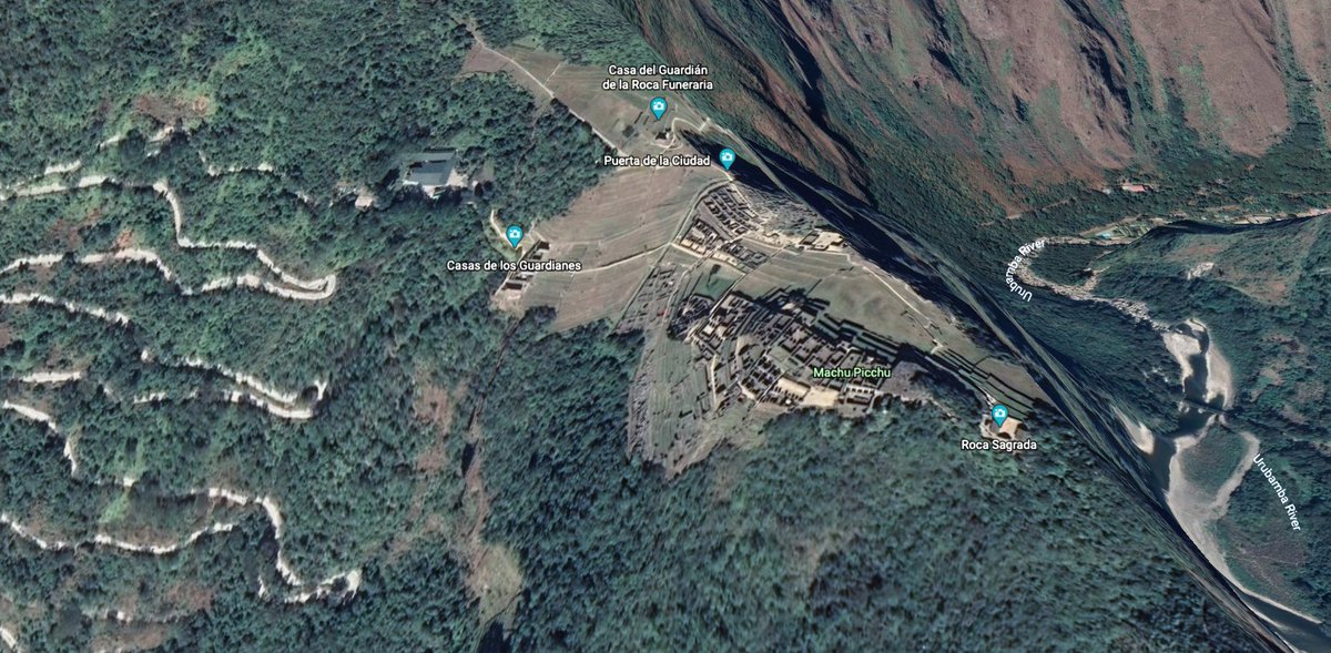
#30DayMapChallenge - Day 11 - 3D Would have liked to plot a 3D model of Machu Picchu, but couldn’t find the data, so posting some screenshots from Google Earth. #EarthPy seems interesting though.


EarthPy: Un paquete de #Python para plotear y trabajar con datos espaciales mappinggis.com/2020/04/earthp… #earthpy
mappinggis.com
EarthPy: Un paquete de Python para plotear y trabajar con datos espaciales
EarthPy es un paquete de Python que facilita la creación de gráficos y el trabajo con datos espaciales utilizando herramientas de código abierto. EarthPy está diseñado para usuarios que son nuevos en...

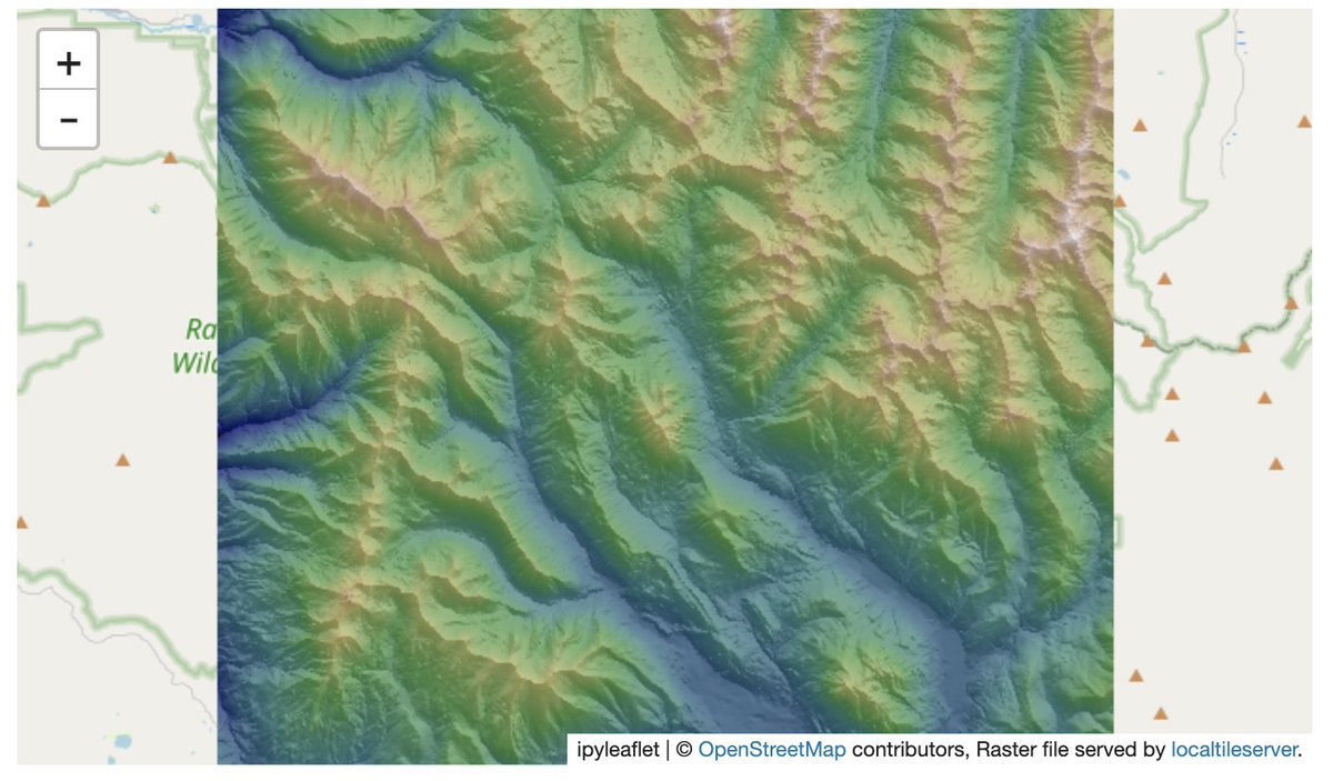
Creación de un #hillshade a partir de un modelo digital de elevación #EarthPy 👇 earthpy.readthedocs.io/en/latest/gall… #Python #geospatial #DEM


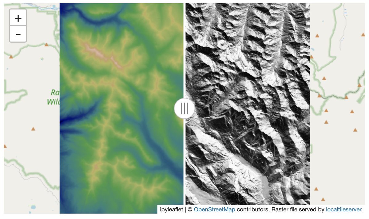
Check out how to make interactive hillshade maps from digital elevation models with #localtileserver (much credit to #EarthPy for the implementation) #geospatial #python #jupyter #ipyleaflet mybinder.org/v2/gh/banesull…

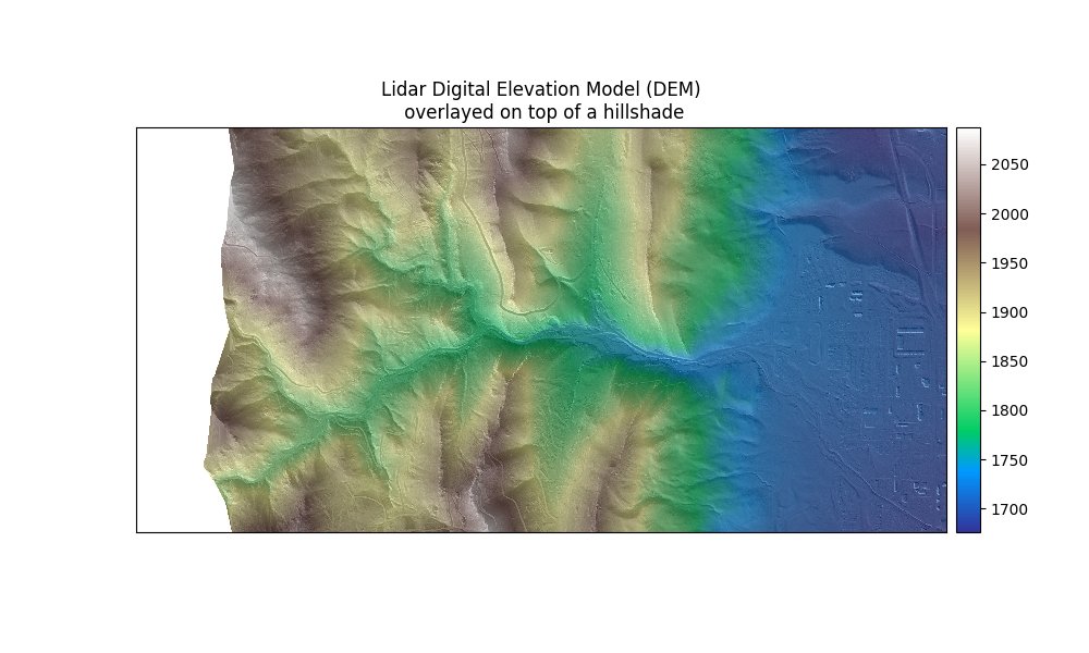
For those of you that work with #Rasterio and #Geopandas, earthpy is worth a look. Here is a nice graphic of a DEM overlayed on top of a hillshade created with #earthpy. pypi.org/project/earthp…


👉¿Conoces EarthPy? Un paquete de #Python para tus trabajos con datos espaciales 😃 Te lo explica @MappingGIS ➡️bit.ly/3jTVWA7 #earthpy #sig #IGNSpain #CNIG
EarthPy: Un paquete de #Python para plotear y trabajar con datos espaciales mappinggis.com/2020/04/earthp… #earthpy
mappinggis.com
EarthPy: Un paquete de Python para plotear y trabajar con datos espaciales
EarthPy es un paquete de Python que facilita la creación de gráficos y el trabajo con datos espaciales utilizando herramientas de código abierto. EarthPy está diseñado para usuarios que son nuevos en...

“#ExploratoryDataAnalysis(EDA) on Satellite Imagery Using #EarthPy” by Syam Kakarla link.medium.com/odyIoiz33ab

@tsherryUSA to start, take a look at Python for Geosciences / #EarthPy: github.com/koldunovn/pyth… & earthpy.org/tag/python-for…
#EarthPy: Python Package for Plotting and Working with Spatial Data ~ GIS Lounge gislounge.com/earthpy-python…

EarthPy: Un paquete de #Python para plotear y trabajar con datos espaciales mappinggis.com/2020/04/earthp… #earthpy
mappinggis.com
EarthPy: Un paquete de Python para plotear y trabajar con datos espaciales
EarthPy es un paquete de Python que facilita la creación de gráficos y el trabajo con datos espaciales utilizando herramientas de código abierto. EarthPy está diseñado para usuarios que son nuevos en...
Check out how to make interactive hillshade maps from digital elevation models with #localtileserver (much credit to #EarthPy for the implementation) #geospatial #python #jupyter #ipyleaflet mybinder.org/v2/gh/banesull…
EarthPy: Un paquete de #Python para plotear y trabajar con datos espaciales mappinggis.com/2020/04/earthp… #earthpy
mappinggis.com
EarthPy: Un paquete de Python para plotear y trabajar con datos espaciales
EarthPy es un paquete de Python que facilita la creación de gráficos y el trabajo con datos espaciales utilizando herramientas de código abierto. EarthPy está diseñado para usuarios que son nuevos en...
👉¿Conoces EarthPy? Un paquete de #Python para tus trabajos con datos espaciales 😃 Te lo explica @MappingGIS ➡️bit.ly/3jTVWA7 #earthpy #sig #IGNSpain #CNIG
EarthPy: Un paquete de #Python para plotear y trabajar con datos espaciales mappinggis.com/2020/04/earthp… #earthpy
mappinggis.com
EarthPy: Un paquete de Python para plotear y trabajar con datos espaciales
EarthPy es un paquete de Python que facilita la creación de gráficos y el trabajo con datos espaciales utilizando herramientas de código abierto. EarthPy está diseñado para usuarios que son nuevos en...
#30DayMapChallenge - Day 11 - 3D Would have liked to plot a 3D model of Machu Picchu, but couldn’t find the data, so posting some screenshots from Google Earth. #EarthPy seems interesting though.
“#ExploratoryDataAnalysis(EDA) on Satellite Imagery Using #EarthPy” by Syam Kakarla link.medium.com/odyIoiz33ab
Creación de un #hillshade a partir de un modelo digital de elevación #EarthPy 👇 earthpy.readthedocs.io/en/latest/gall… #Python #geospatial #DEM
For those of you that work with #Rasterio and #Geopandas, earthpy is worth a look. Here is a nice graphic of a DEM overlayed on top of a hillshade created with #earthpy. pypi.org/project/earthp…
#EarthPy: Python Package for Plotting and Working with Spatial Data ~ GIS Lounge gislounge.com/earthpy-python…


#30DayMapChallenge - Day 11 - 3D Would have liked to plot a 3D model of Machu Picchu, but couldn’t find the data, so posting some screenshots from Google Earth. #EarthPy seems interesting though.
Creación de un #hillshade a partir de un modelo digital de elevación #EarthPy 👇 earthpy.readthedocs.io/en/latest/gall… #Python #geospatial #DEM
Check out how to make interactive hillshade maps from digital elevation models with #localtileserver (much credit to #EarthPy for the implementation) #geospatial #python #jupyter #ipyleaflet mybinder.org/v2/gh/banesull…
For those of you that work with #Rasterio and #Geopandas, earthpy is worth a look. Here is a nice graphic of a DEM overlayed on top of a hillshade created with #earthpy. pypi.org/project/earthp…
Something went wrong.
Something went wrong.
United States Trends
- 1. Penn State 23.2K posts
- 2. Indiana 38.7K posts
- 3. Mendoza 20.2K posts
- 4. Gus Johnson 6,764 posts
- 5. #UFCVegas111 5,107 posts
- 6. #iufb 4,197 posts
- 7. Sayin 69.2K posts
- 8. Omar Cooper 9,572 posts
- 9. Iowa 19.5K posts
- 10. Estevao 39.1K posts
- 11. Josh Hokit N/A
- 12. Sunderland 155K posts
- 13. Mizzou 3,730 posts
- 14. Kirby Moore N/A
- 15. Texas Tech 13.9K posts
- 16. Jim Knowles N/A
- 17. Happy Valley 1,908 posts
- 18. James Franklin 8,851 posts
- 19. Carter Smith N/A
- 20. Oregon 33.7K posts