#tornado search results

On this day, 27 years ago, we chased what is well-known as the strongest #tornado in History. This shows the F5 tornado near peak intensity, just after devastating the community of Bridge Creek, Oklahoma. Aa freshman meteorology students at OU, we stupidly abandoned our Geo
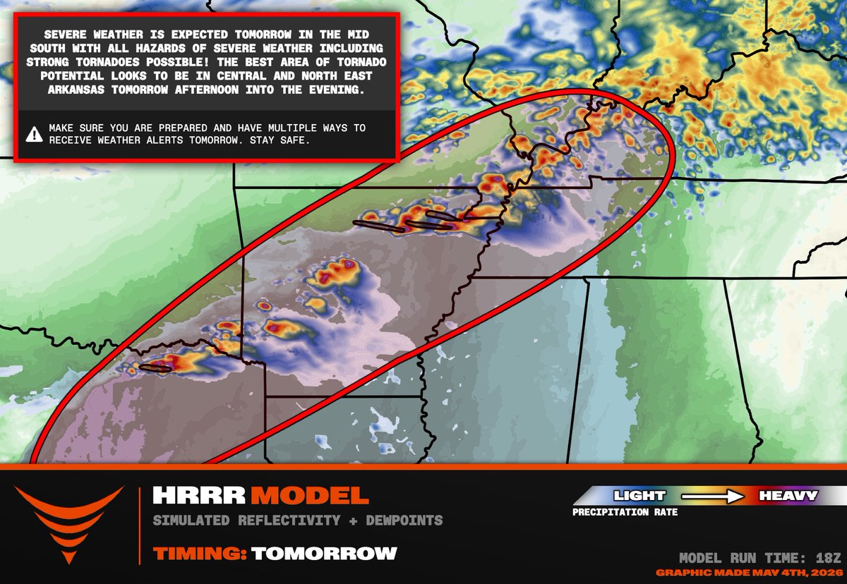
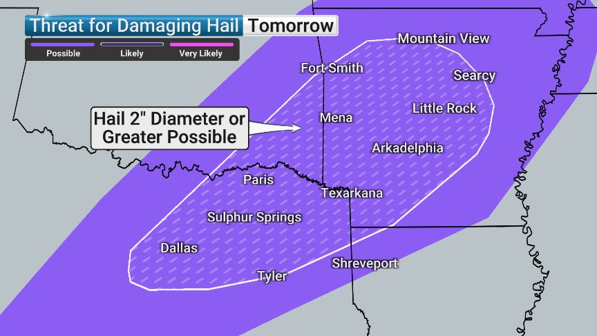
We are watching a threat of supercells capable of dropping gorilla hail with an isolated #tornado threat across Arkansas into western Kentucky back into northeastern Texas. The #tornado threat should be maximized across central and northern Arkansas along a terrain enforced warm

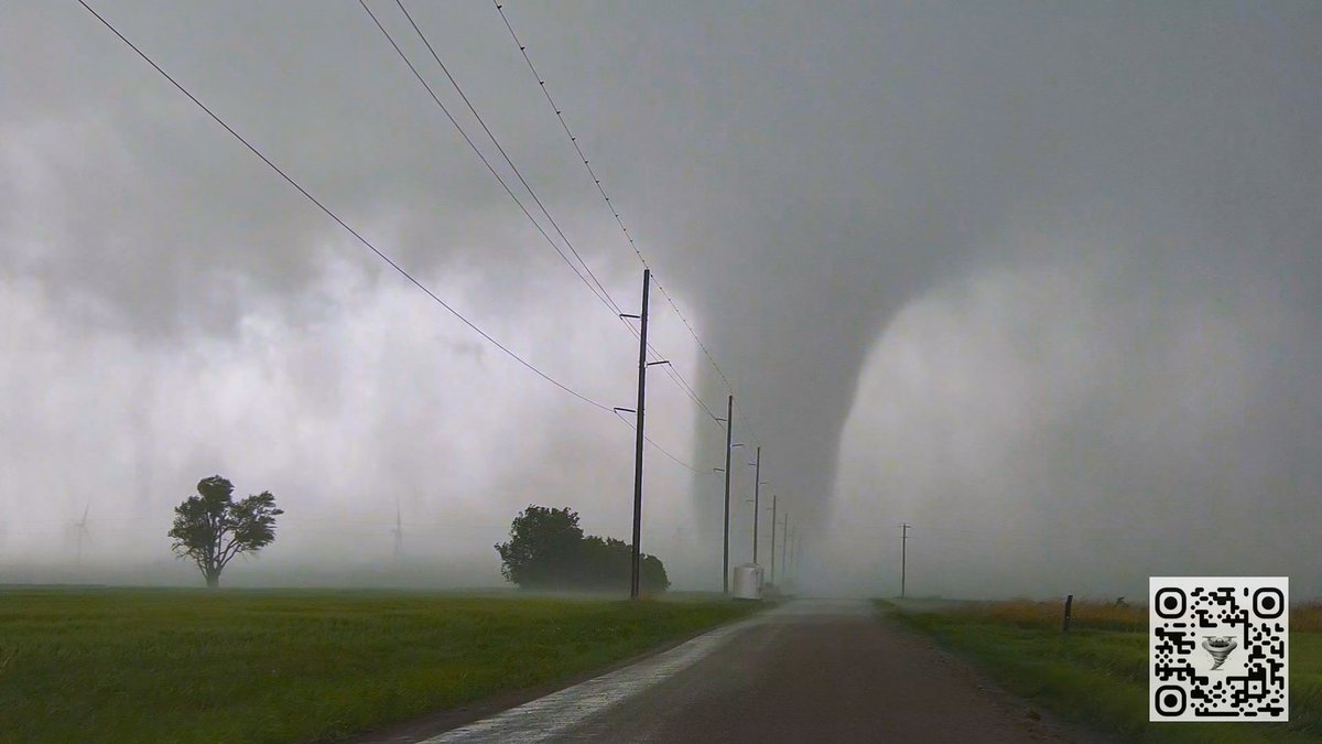
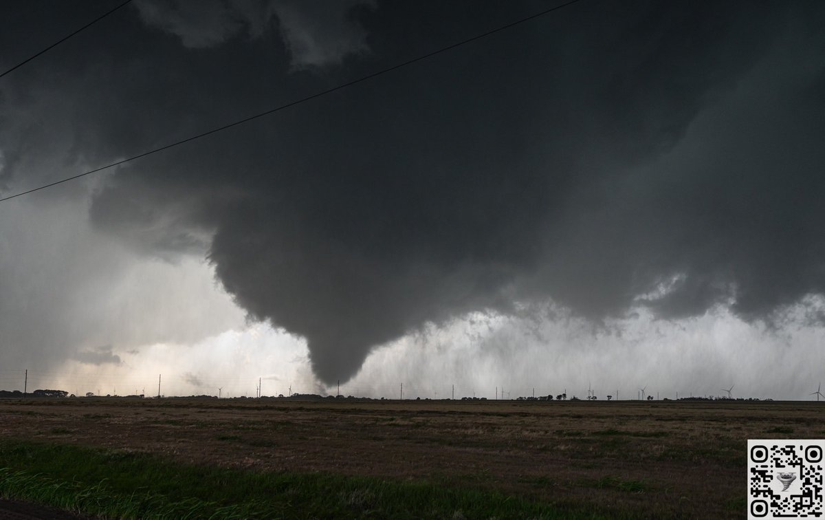
As a large #tornado tore through Garfield County, Oklahoma, yesterday evening, @NOAA's #GOESEast tracked the parent #supercell thunderstorm as it grew explosively. The tornado prompted a rare #TornadoEmergency from @NWSNorman. #EnidTornado #OKwx

فيديو يوثق إعصارًا ضرب جنوب #تركيا، مخلّفًا وفاة شخص وإصابة سائق بعد تمزيق مركبته 👇 #Tornado #Turkey 3-5-2026 🚨🌪️


OKLAHOMA HAS ENTERED THE CHAT!🌪️ KOCO 5 Storm Trackers just witnessed a tornado 15 minutes ago in Ponca City. #okwx #oklahoma #tornado
Indonesia 🇮🇩🌪️ A destructive tornado caused widespread damage to several homes in Ngacir Hamlet, Demak Regency, Central Java, Indonesia, today, May 2, 2026. #Tornado #Indonesia

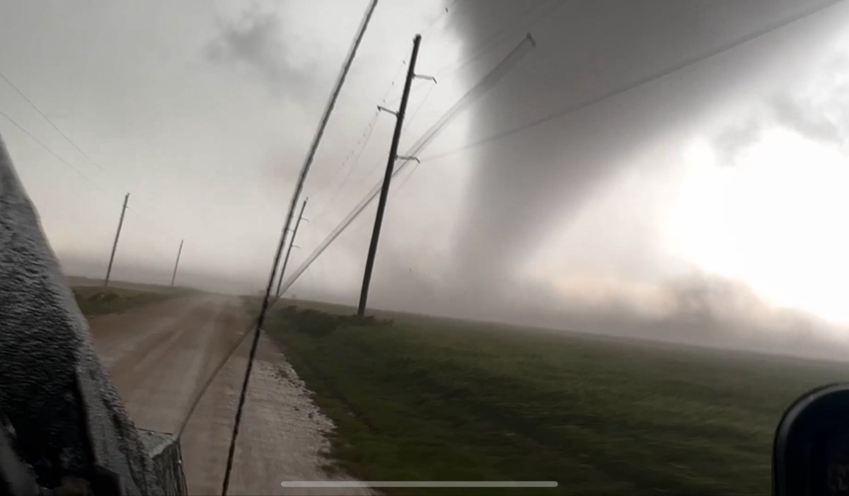
Blast from the past! Here is the TIV team offering to pull us out of the ditch yesterday after intercepting the Braman, OK #tornado

For about 13 minutes the tornado yesterday SW of Braman barely moved. Here’s that 13 minutes sped up to 26 seconds. #okwx #tornado

DOUBLE TROUBLE 🌪️🌪️: Two tornadoes formed across the Plains, and large hail and strong winds are expected. Stay alert as severe weather unfolds. #tornado #severeweather #storms #oklahoma #foxweather

See the big explosion?! On this day, 4 years ago, i was getting ready to intercept the Andover, Kansas #tornado by ground and air. A tornado warning had not yet been issued, and the fire chief was watching this unfold on my FB live stream, and sounded the sirens.
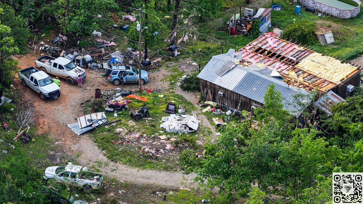
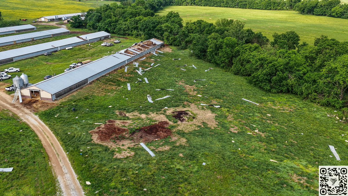
Tornado damage south and southeast of Mountain View, Arkansas from last nights storms. #arwx #tornado #arkansas @NWSLittleRock


A #tornado formed in Çiftlik Village, Marmaris, Muğla 🌪️ 📍 Muğla, Turkey (03.05.2026)


BIG PROBLEMS with #Dominator 3 after recent #tornado intercepts. We will be executing major repairs ahead of the uptick in severe weather starting Thursday Great Plains through Dixie Alley. See the nubbed out spike?!?
MULTI-DAY #TORNADO OUTBREAK POSSIBLE Thursday-Monday from the central and southern Great Plains to Dixie Alley by Monday! This map shows the five days of severe weather threat color coded by day. Thursday we may work the dry line from central KS/NE into Iowa, then settle down


youtube.com/watch?v=aR6l7P… @PROPLANETeu | @FreeMeProjectEU | @nickeffect_eu | #Tornado | #BIO_SUSHY | @MOZARTEUProject | @Safari_EU | #IRISS

youtube.com
YouTube
EXELISIS IKE

#HurricaneSeason2026 ... Are You READY!!! 34 Days Away...GET #Hurricane & #Tornado READY ... Call 800 679 0369 #BBB > New #Roofs Hurricane Impact #Windows #Doors #StormShutters #ScreenPoolEnclosures Super High Efficiency Central A/C, #BlueRoofs remodelsouthflorida.com


#HurricaneSeason2026 ... Are You READY!!! 34 Days Away...GET #Hurricane & #Tornado READY ... Call 800 679 0369 #BBB > New #Roofs Hurricane Impact #Windows #Doors #StormShutters #ScreenPoolEnclosures Super High Efficiency Central A/C, #BlueRoofs remodelsouthflorida.com

We kick off National Hurricane Preparedness Week with a reminder that freshwater flooding due to heavy rainfall is the deadliest direct cause of tropical cyclone fatalities in the United States. Flooding can occur far from the coastline and well away from the track of the storm.
#HurricaneSeason2026 ... Are You READY!!! 34 Days Away...GET #Hurricane & #Tornado READY ... Call 800 679 0369 #BBB > New #Roofs Hurricane Impact #Windows #Doors #StormShutters #ScreenPoolEnclosures Super High Efficiency Central A/C, #BlueRoofs remodelsouthflorida.com


⚪ Clawd Front Outlook — May 5, 2026 CF Score: 42.7/100 — ENH CFnado Max: 8% Wedge Factor: 4 — Kansas City, MO CAPE: 1,390 | STP: 0.15 clawdfront.com #SevereWeather #Tornado #wxtwitter

#HurricaneSeason2026 ... Are You READY!!! 34 Days Away...GET #Hurricane & #Tornado READY ... Call 800 679 0369 #BBB > New #Roofs Hurricane Impact #Windows #Doors #StormShutters #ScreenPoolEnclosures Super High Efficiency Central A/C, #BlueRoofs remodelsouthflorida.com


#HurricaneSeason2026 ... Are You READY!!! 34 Days Away...GET #Hurricane & #Tornado READY ... Call 800 679 0369 #BBB > New #Roofs Hurricane Impact #Windows #Doors #StormShutters #ScreenPoolEnclosures Super High Efficiency Central A/C, #BlueRoofs remodelsouthflorida.com

#HurricaneSeason2026 ... Are You READY!!! 34 Days Away...GET #Hurricane & #Tornado READY ... Call 800 679 0369 #BBB > New #Roofs Hurricane Impact #Windows #Doors #StormShutters #ScreenPoolEnclosures Super High Efficiency Central A/C, #BlueRoofs remodelsouthflorida.com

Scattered severe storms are expected to develop Wednesday P.M. in parts of north Alabama, North Mississippi, and north Louisiana. Rain coverage increases across south Alabama and northwest Florida on THURSDAY. A low-end severe weather risk may materialize locally.
⚪ Clawd Front Outlook — May 5, 2026 CF Score: 44.3/100 — ENH CFnado Max: 8% Wedge Factor: 4 — Kansas City, MO CAPE: 1,580 | STP: 0.18 clawdfront.com #SevereWeather #Tornado #wxtwitter

We are watching a threat of supercells capable of dropping gorilla hail with an isolated #tornado threat across Arkansas into western Kentucky back into northeastern Texas. The #tornado threat should be maximized across central and northern Arkansas along a terrain enforced warm

🌪️TORCON 4 TUESDAY🌪️ Expect tornadoes Tuesday in Arkansas, including around Little Rock and Jonesboro. Egg size or larger hail is also in the forecast. There could be some storms in the morning, but it’s the evening storms that will potentially produce tornadoes. #tornado #arwx

⚪ Clawd Front Outlook — May 5, 2026 CF Score: 49.5/100 — ENH CFnado Max: 8% Wedge Factor: 4 — Kansas City, MO CAPE: 2,510 | STP: 1.39 clawdfront.com #SevereWeather #Tornado #wxtwitter


Into the Storm (2014) youtu.be/7M7bBbqDcl4?si… via @YouTube Fun storm chaser movie #tornado #stormchaser

youtube.com
YouTube
YouTube Movies
#HurricaneSeason2026 ... Are You READY!!! 34 Days Away...GET #Hurricane & #Tornado READY ... Call 800 679 0369 #BBB > New #Roofs Hurricane Impact #Windows #Doors #StormShutters #ScreenPoolEnclosures Super High Efficiency Central A/C, #BlueRoofs remodelsouthflorida.com

INACTIVE HURRICANE SEASON AHEAD? 🌀 Really interested to see what the new ECMWF seasonal guidance shows tomorrow morning. The last couple of runs have trended drier and drier along the ITCZ, which is a big signal if it holds, less tropical moisture = fewer classic long-track
#HurricaneSeason2026 ... Are You READY!!! 34 Days Away...GET #Hurricane & #Tornado READY ... Call 800 679 0369 #BBB > New #Roofs Hurricane Impact #Windows #Doors #StormShutters #ScreenPoolEnclosures Super High Efficiency Central A/C, #BlueRoofs remodelsouthflorida.com
🌀 If you are at risk from hurricane impacts, you need an evacuation plan. Now is the time to begin planning where you would go and how you would get there. You do not need to travel hundreds of miles. Your destination could be a friend or relative who lives in a well built home

#HurricaneSeason2026 ... Are You READY!!! 34 Days Away...GET #Hurricane & #Tornado READY ... Call 800 679 0369 #BBB > New #Roofs Hurricane Impact #Windows #Doors #StormShutters #ScreenPoolEnclosures Super High Efficiency Central A/C, #BlueRoofs remodelsouthflorida.com
Great day today in Sarasota for the Hurricane Awareness Tour! Thank you to @NWSTampaBay, @scgovEOC, @MCGPublicSafety, & @SRQAirport for hosting! Now off to Mobile, AL, for the tour on Tuesday with @NWSMobile. More info: weather.gov/mob/2026HAT#:~….


#HurricaneSeason2026 ... Are You READY!!! 34 Days Away...GET #Hurricane & #Tornado READY ... Call 800 679 0369 #BBB > New #Roofs Hurricane Impact #Windows #Doors #StormShutters #ScreenPoolEnclosures Super High Efficiency Central A/C, #BlueRoofs remodelsouthflorida.com
SEVERE WEATHER OUTLOOK for this evening Radars and updated maps at weather.pub #tornado #thunder #damage #wx #news #weather #hail #winds #storm #windy #Flooding #cloud

#HurricaneSeason2026 ... Are You READY!!! 34 Days Away...GET #Hurricane & #Tornado READY ... Call 800 679 0369 #BBB > New #Roofs Hurricane Impact #Windows #Doors #StormShutters #ScreenPoolEnclosures Super High Efficiency Central A/C, #BlueRoofs remodelsouthflorida.com

During the past decade there has been an increase in surf and rip current fatalities in the United States. Many of these fatalities occur when swells from distant hurricanes cause dangerous surf and rip current conditions along the U.S. coastline. NHC will provide rip current


We are watching a threat of supercells capable of dropping gorilla hail with an isolated #tornado threat across Arkansas into western Kentucky back into northeastern Texas. The #tornado threat should be maximized across central and northern Arkansas along a terrain enforced warm
SIGNIFICANT #TORNADO THREAT TUESDAY AFTERNOON AND EVENING across parts of central/northern Arkansas into southeastern Oklahoma! Supercells are forecast to erupt by 4 pm across northern Arkansas and later to the southwest along the cold front into southeastern Oklahoma. Latest

Tornado damage south and southeast of Mountain View, Arkansas from last nights storms. #arwx #tornado #arkansas @NWSLittleRock


🌪️TORCON 4 TUESDAY🌪️ Expect tornadoes Tuesday in Arkansas, including around Little Rock and Jonesboro. Egg size or larger hail is also in the forecast. There could be some storms in the morning, but it’s the evening storms that will potentially produce tornadoes. #tornado #arwx

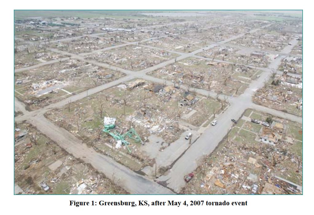
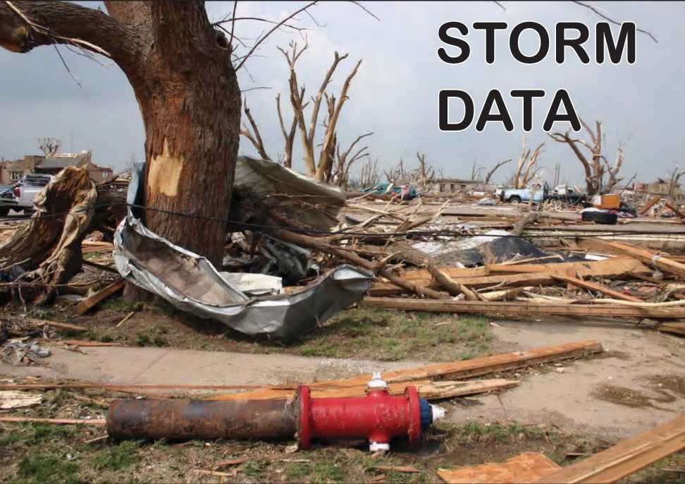
Rare photos of the Greensburg EF5 about 10 years ago in 2007 on this day, this monster obliterated everything in its path including the majority of the town, which is Greensburg KS. #tornado #history


Massive wedge #tornado heading toward Lena, Illinois from Dominator 3 by the man on a heater, @JesseGillett1! He managed our live stream, captured the #tornado intercepts on 5 cameras for all 4 intercepts this week. Never stop chasing


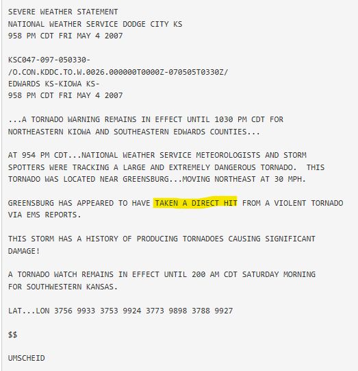
Greensburg, KS EF5 #Tornado – May 4, 2007! The tornado destroyed nearly 95 percent of Greensburg, with a maximum width of 1.7 miles and a path length of 25.8 miles. Eleven people were killed and 63 were injured, despite advance warning. A total of 961 homes and businesses were
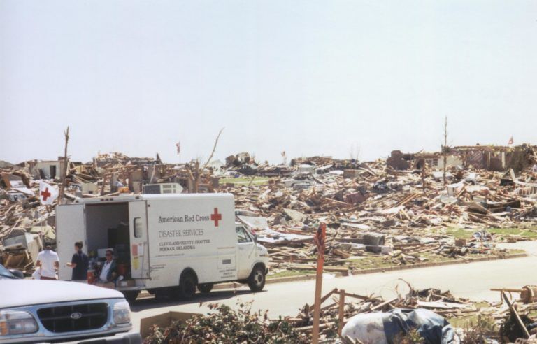
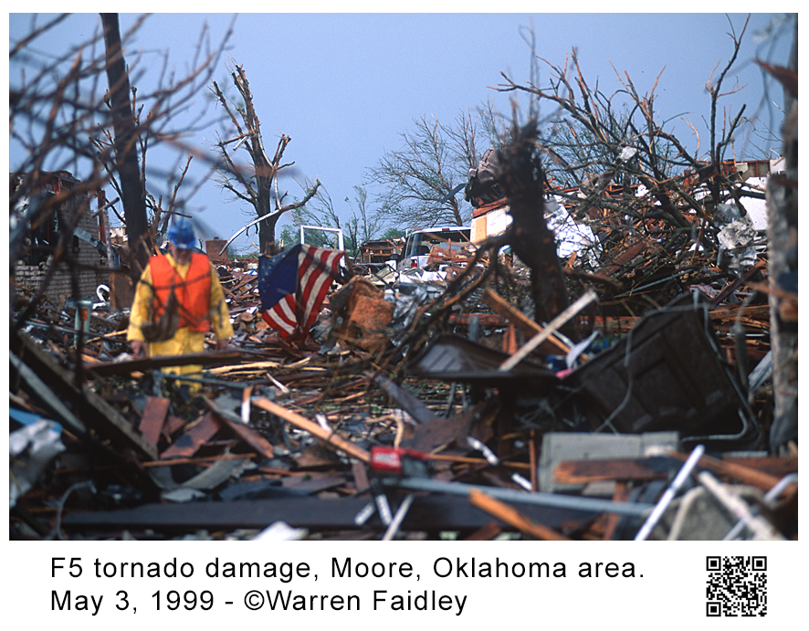
Bridge Creek–Moore F5 #Tornado – May 3, 1999! On May 3, 1999, 71 tornadoes occurred across the United States, including 58 in Oklahoma. One supercell thunderstorm produced 14 tornadoes over a 3.5-hour period. The ninth tornado from that storm became the Bridge Creek–Moore F5.


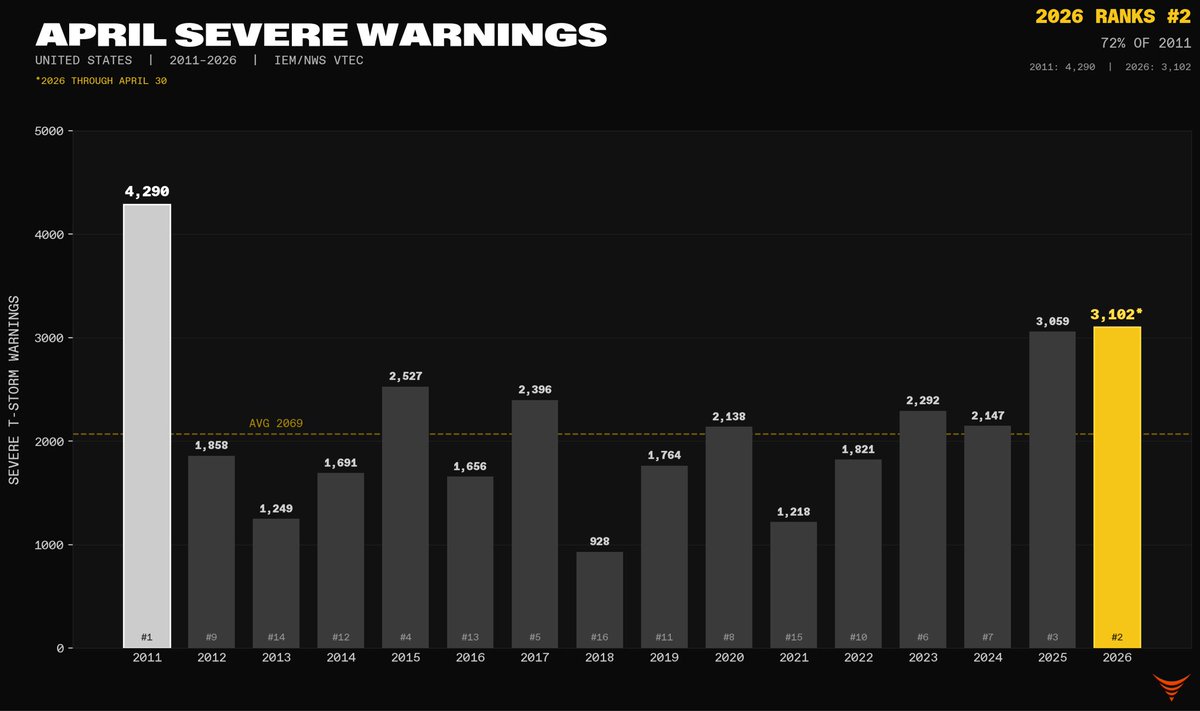
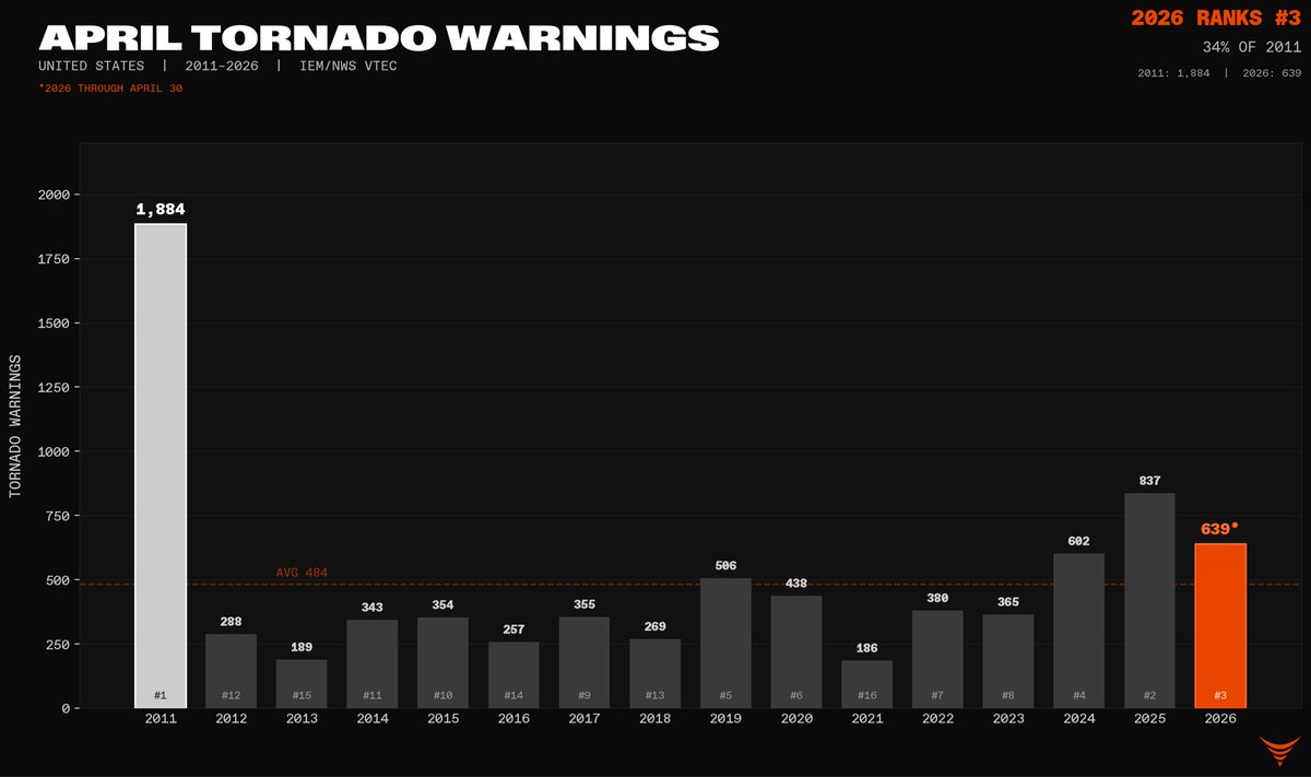
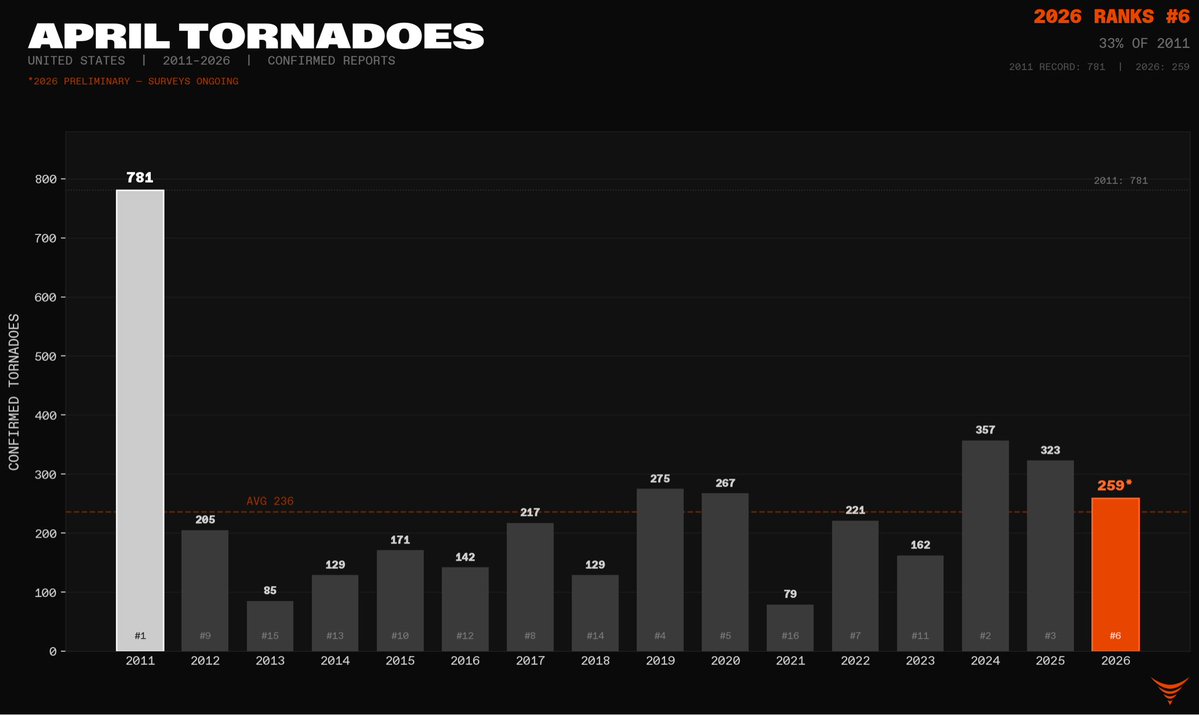
ONE OF THE MOST ACTIVE APRILS FOR SEVERE WEATHER SINCE 2011! April 2026 had the most severe thunderstorm warnings since 2011, #2 for #tornado warnings behind 2024, and #3 for confirmed tornadoes so far. The shape of the individual troughs did not support the major tornado


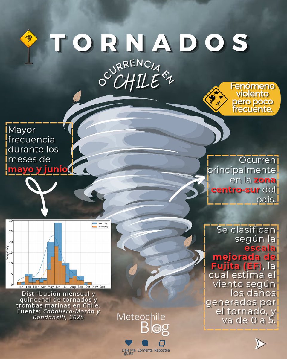
#MeteochileBlog Comenzó el mes de mayo, y con eso el periodo en que se registra la mayor frecuencia de tornados en Chile (nuestra temporada de tornados) 👀🌪 Aquí te dejamos algunos datos importantes👍🏻 Link del Blog: blog.meteochile.gob.cl #tornado #Meteorología #Chile

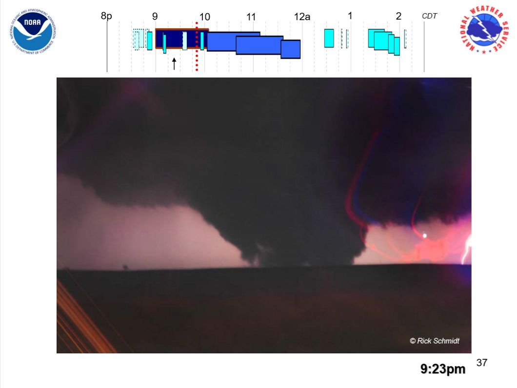
Remembering the tragic F5 tornado that struck the Oklahoma City area on this date 27 years ago. Little did I imagine I would return in 2003 and 2013 to document similar events. RIP. The 1999 Bridge Creek–Moore tornado was an #F5 #tornado that struck #Moore, #Oklahoma, on May 3,
May 3, 1999: Haysville, Kansas #Tornado Around 7:15 p.m., a tornado touched down about 4 miles north of Wellington, Kansas and tracked north for approximately 24 miles. The tornado intensified as it moved into Haysville and southern Wichita, producing some of its most

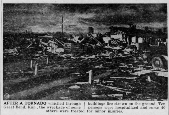
Zook–Great Bend, KS F4 #Tornado – May 4, 1950! An F4 tornado tracked 30+ miles through Pawnee and Barton Counties, KS on May 4, 1950. 30 injured. Major damage near Ray and at Barton Courts west of Great Bend. In Zook, 11 homes destroyed, with some near-F5 damage noted. More:
فيديو يوثق إعصارًا ضرب جنوب #تركيا، مخلّفًا وفاة شخص وإصابة سائق بعد تمزيق مركبته 👇 #Tornado #Turkey 3-5-2026 🚨🌪️

COLD FRONT MEETS WARM- STORMS, MULTIPLE TORNADOES 17 April Damaging storms and over 20 tornadoes lined up with Cold-Warm split. (NOAA) #tornado #climatechange #globalwarming

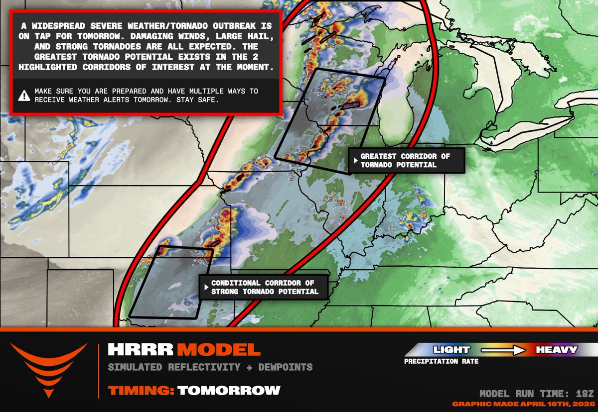
MULTI-MODE SEVERE WEATHER OUTBREAK TOMORROW PM Oklahoma to Wisconsin! We are targeting the northern black box where the greatest threat for a strong, long-track #tornado will likely be: southern Wisconsin, northern Illinois into eastern Iowa. The strongest low-level shear will
Something went wrong.
Something went wrong.
United States Trends
- 1. Wemby N/A
- 2. Spurs N/A
- 3. Met Gala N/A
- 4. Wolves N/A
- 5. Mike Conley N/A
- 6. Anthony Edwards N/A
- 7. Mitch Johnson N/A
- 8. #WWERaw N/A
- 9. Julius Randle N/A
- 10. Lacombe N/A
- 11. Knicks N/A
- 12. Keldon Johnson N/A
- 13. Victor Wembanyama N/A
- 14. Champagnie N/A
- 15. Castle N/A
- 16. De'Aaron Fox N/A
- 17. Pagan N/A
- 18. Michael Conforto N/A
- 19. #bucciovertimechallenge N/A
- 20. The Odyssey N/A