#funwithmaps search results


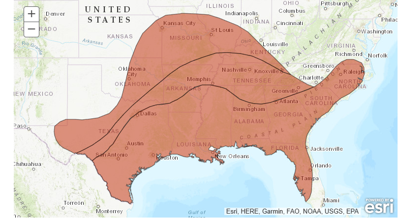
Much of the deep south, mid Mississippi valley and the southeast could experience dangerous heat headed into the holiday weekend. That or a GIANT RED TURTLE!!!! Do you see it?? #Funwithmaps #chswx


Maps showing Germany (or German-speaking countries) being exceptional in Europe: an ongoing THREAD 1. The lowest share of homeowners


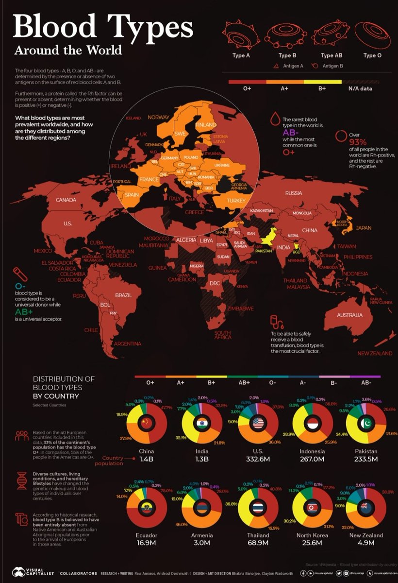
Most common blood types around the world- Whats interesting for me is that only #Pakistan and #Bangladesh have majority B+ people in their population for some reason. #funwithmaps image credit: visualcapitalist.com.

#FunWithMaps 😵💫😵💫

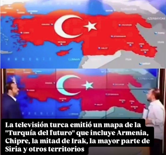
Turquía, entregada al islamismo más recalcitrante, miembro (todavía) de la OTAN. Los hipócritas.
Lol Used to win a lot of trivia w/ Lesotho even though I pronounce it differently each time #geography #funwithmaps

This town is so full of people just BURSTING to tell you they’ve heard of Lesotho. It will be the No. 1 happy hour discussion point tomorrow. I’m one of them. I’ve heard of Lesotho. Known about it for years.

Playing with different backgrounds and colors of the map layers.... Does it look 3D??? public.tableau.com/views/3D_17490… #Tableau #TableauPublic #FunWithMaps


Combining #funwithmaps & #Eclipse2024 axios.com/2024/04/05/air…


You haven’t hit my county yet! #FunWithMaps #GeographyNerdTwitter

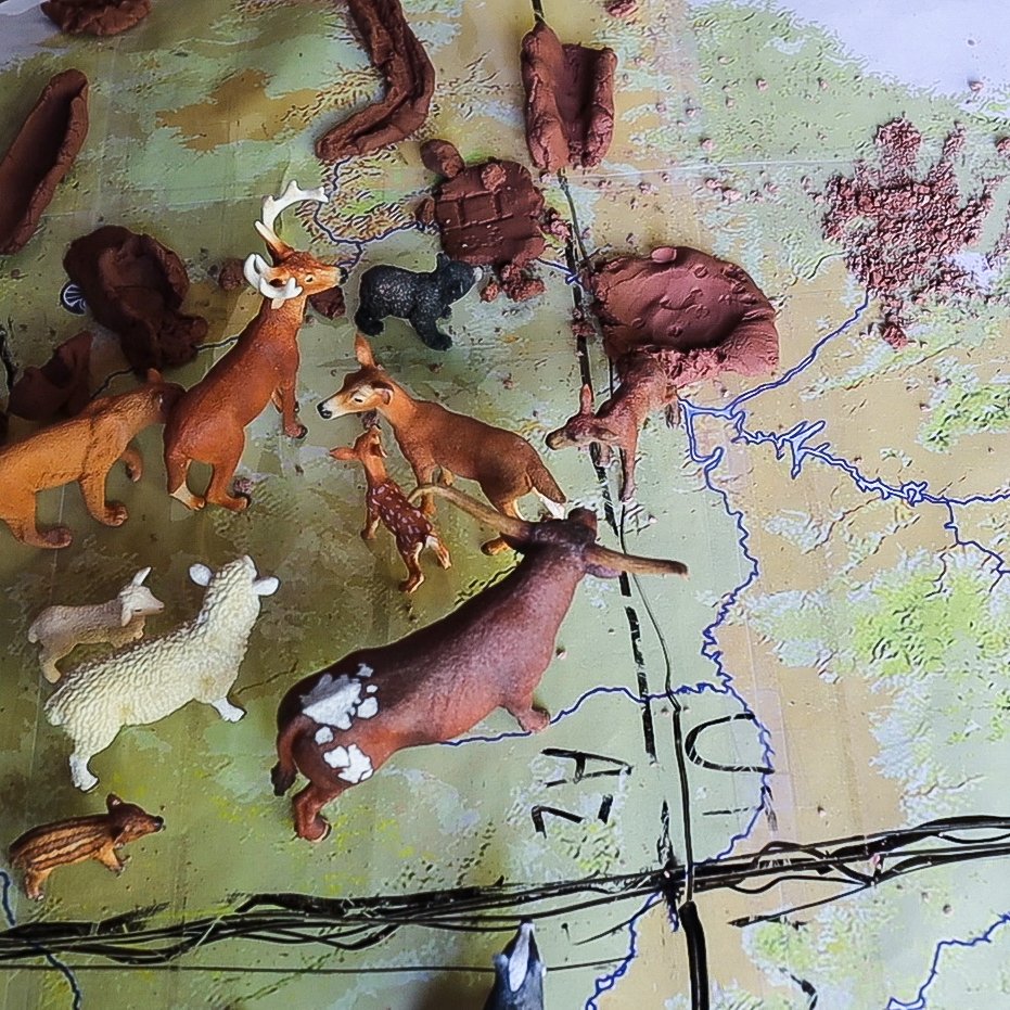
Sometimes learning is messy. Here we have the leftovers after kids at our Science Day marked a Colorado Plateau map with the mountains, rivers, and animals. They got very creative! #funwithmaps #ColoradoPlateau


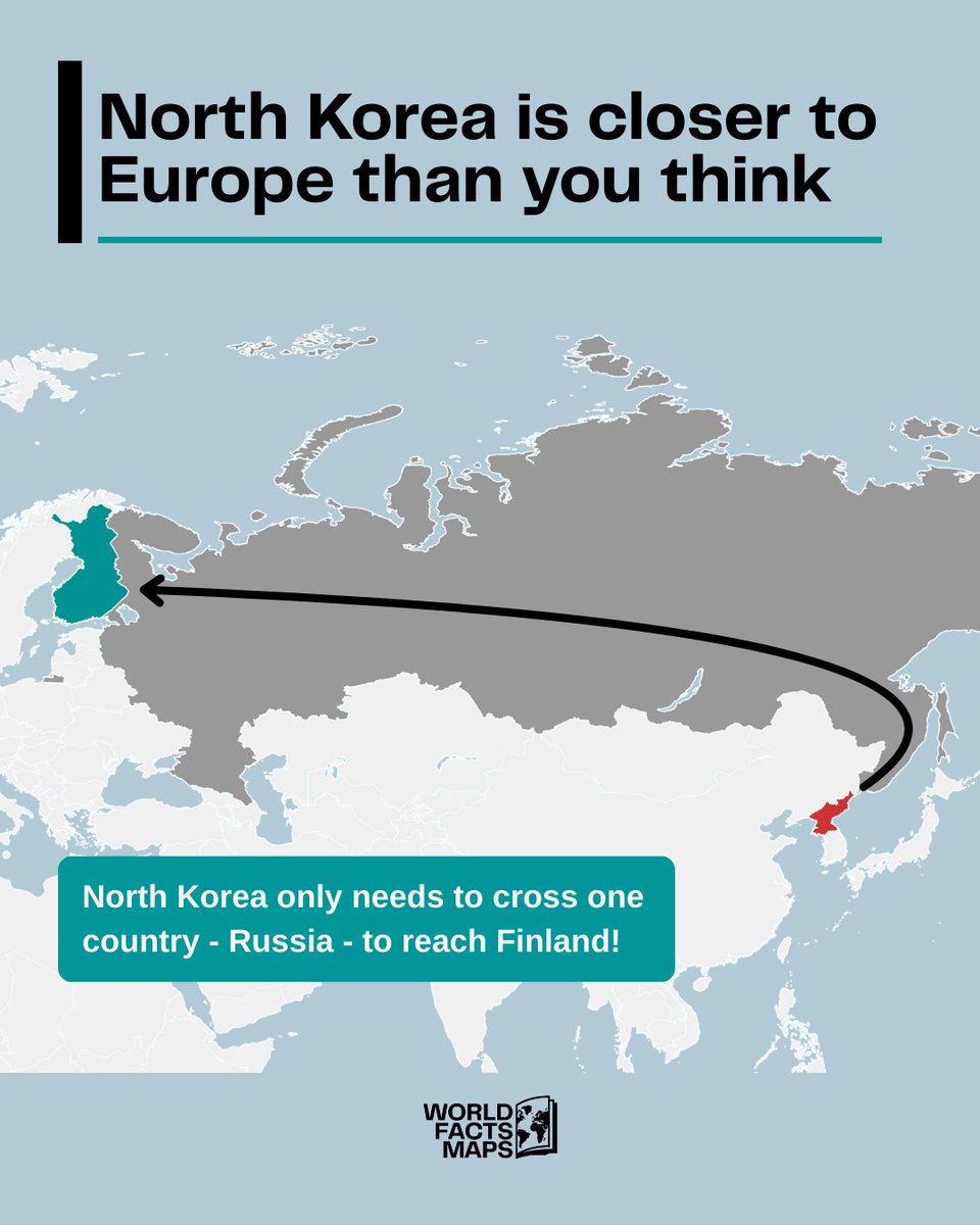
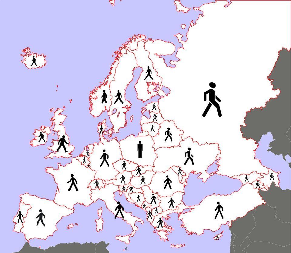
North Korea and Finland: Just two introverts separated by one really big backyard. 🌍🇰🇵➡️🇷🇺➡️🇫🇮 #GeographyFacts #FunWithMaps #DidYouKnow #NorthKorea #Finland #Russia #MapHumor #WorldFacts


@AlexDiez mira!! #FunWithMaps

Cómo China ha superado a EE.UU. como principal socio comercial del mundo

If you enjoyed this thread: 🔁 Repost this thread to spread the word 🤝 Follow for more #dataviz📊 and #funwithmaps😀💬 Drop a comment Let's visualize the world's infrastructure together 🌍⚡ x.com/PabloHernandez…
📢 NEW MAP ALERT! 🗺 Venezuela's energy infrastructure—visualized in 3D 🌟 37 power plants mapped across the country: 💧 9 Hydroelectric 🔵 🔥 28 Natural Gas 🟡 Geography tells the story. Time for another #1week1project📅💻 with #RStats + rayshader! Let's open a 🧵 👇


Here are the current Pennsylvania voter registration numbers by Congressional District. Drag your mouse across a district to find out the total registered voters and percentage breakdown of Democrats, Republicans, and Independents. #PoliticsPA #FunWithMaps
North Korea and Finland: Just two introverts separated by one really big backyard. 🌍🇰🇵➡️🇷🇺➡️🇫🇮 #GeographyFacts #FunWithMaps #DidYouKnow #NorthKorea #Finland #Russia #MapHumor #WorldFacts

Which one do you see when you look at Australia? 🐶🦆🦖🥔 Some say it looks like a dog’s head, others see a duck, a dinosaur, or even a potato! What do you think it looks like the most? Comment your vote! 👇🇦🇺 #BestFreeToursSydney #AustraliaMap #FunWithMaps #AustralianHumour

Playing with different backgrounds and colors of the map layers.... Does it look 3D??? public.tableau.com/views/3D_17490… #Tableau #TableauPublic #FunWithMaps


#FunWithMaps 😵💫😵💫
Turquía, entregada al islamismo más recalcitrante, miembro (todavía) de la OTAN. Los hipócritas.
Sometimes learning is messy. Here we have the leftovers after kids at our Science Day marked a Colorado Plateau map with the mountains, rivers, and animals. They got very creative! #funwithmaps #ColoradoPlateau


Most common blood types around the world- Whats interesting for me is that only #Pakistan and #Bangladesh have majority B+ people in their population for some reason. #funwithmaps image credit: visualcapitalist.com.
North Korea and Finland: Just two introverts separated by one really big backyard. 🌍🇰🇵➡️🇷🇺➡️🇫🇮 #GeographyFacts #FunWithMaps #DidYouKnow #NorthKorea #Finland #Russia #MapHumor #WorldFacts
Much of the deep south, mid Mississippi valley and the southeast could experience dangerous heat headed into the holiday weekend. That or a GIANT RED TURTLE!!!! Do you see it?? #Funwithmaps #chswx

Which one do you see when you look at Australia? 🐶🦆🦖🥔 Some say it looks like a dog’s head, others see a duck, a dinosaur, or even a potato! What do you think it looks like the most? Comment your vote! 👇🇦🇺 #BestFreeToursSydney #AustraliaMap #FunWithMaps #AustralianHumour


"I'm not blushing, you're blushing! Thanks to folks at Estately for putting together this map of the most lewd-sounding town name in each state. Enjoy putting your mind in the gutter for a few minutes and having some chuckles! Source: estately.com/blog/2016/09/t… #mapgeek #funwithmaps

Sometimes learning is messy. Here we have the leftovers after kids at our Science Day marked a Colorado Plateau map with the mountains, rivers, and animals. They got very creative! #funwithmaps #ColoradoPlateau
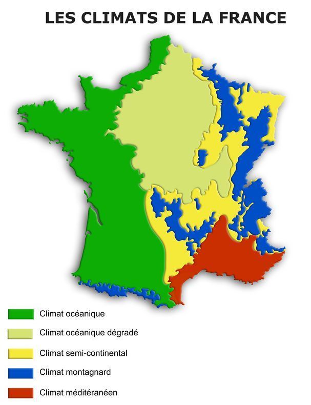
Expérience de discrimination liée à l’accent (glottophobie) #carte #funwithmaps #jaimelescartes #mapmaker


Couleur moyenne de chaque pays (imagerie satellite Sentinel-2) #cartes #funwithmaps #jaimelescartes #maps

Something went wrong.
Something went wrong.
United States Trends
- 1. #Survivor50 N/A
- 2. #AEWDynamite N/A
- 3. #PresidentialAddress N/A
- 4. NASA N/A
- 5. Artemis II N/A
- 6. Stone Age N/A
- 7. Gavin Williams N/A
- 8. Colby N/A
- 9. Blackwood N/A
- 10. Genevieve N/A
- 11. #TheMaskedSinger N/A
- 12. Challenger N/A
- 13. Jericho N/A
- 14. #GoAvsGo N/A
- 15. Canucks N/A
- 16. Tanner Scott N/A
- 17. Apollo N/A
- 18. Paul George N/A
- 19. Simon's Cat N/A
- 20. SpaceX N/A