#geospatialai risultati di ricerca

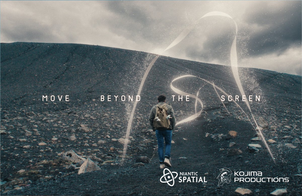
本日、@KojiPro2015 ご主催の "Beyond The Strand" にて、KOJIMA PRODUCTIONS と#NianticSpatial は技術提供のパートナーシップを発表しました。 詳しくは、ブログをご覧ください。 nianticspatial.com/blog/kojima-pr… #GeospatialAI #KojimaProductions #KJP10th

ChatGPT but for maps.💡Here's a first look at our work on a Smart Mapping Assistant prototype that combines the power of GIS with generative AI. esri.social/Sezi50RixSO #AIinMapping #GeospatialAI

🚀 GeoAI v0.16.0 is here! Train image segmentation models and instantly visualize performance metrics with a single line of Python code. 💡 📦 GitHub: github.com/opengeos/geoai 📓 Example notebook: opengeoai.org/examples/train… #GeoAI #DeepLearning #GeospatialAI #Python #OpenSource…


In 2025, AI is transforming geospatial workflows! At TopoDOT, our AI tools enhance efficiency and quality. We’re excited to continue to leverage AI to streamline your work! #GeospatialAI #TopoDOT #AIInEngineering #PointCloudProcessing

Planet Labs (NYSE: PL) stock rises as Pelican-5 and Pelican-6 extend edge-AI capabilities in orbit business-news-today.com/planet-labs-ny… #PlanetLabs #SatelliteImaging #GeospatialAI #PelicanSatellite #EarthObservation #SpaceTech #NVIDIAJetson #RemoteSensing #SuperDoves #SpaceXLaunch #SpaceX


Students from Islamabad’s Institute of Space Technology, Ahmed Iqbal and Hanzila Bin Younas, turned their final-year project into an award-winning innovation. #GeoGemma #GeospatialAI #ISTPakistan #APACChallenge2025


With #geospatialAI agents and #intelligentGIS automation driving insight, we’re moving beyond traditional workflows to create systems that are adaptive, scalable, and built for the future of #infrastructure management. Register for this webinar: hubs.ly/Q03Nn29R0


#GeospatialAI, combining artificial intelligence (#AI) with geographic information systems (GIS), is transforming our understanding of the planet. By automating data processing and uncovering hidden patterns in vast geospatial datasets, Geospatial AI revolutionizes various…


Each dimension of Google Earth AI’s Population Dynamics Foundations embeddings shows unique patterns by ZIP code. 🏘️ See how GeoAI data reveal hidden insights: research.google/blog/google-ea… #Geoawesome #GeospatialAI #DataViz

Natural resources management is getting an #AI upgrade. 🚀From governance to Smart Governance with #GeospatialAI Agents. Discover how AI is transforming: Real Estate Reg, Spatial Planning, Farmland Protection, and Govt. Services. Read the full story: bit.ly/4nedRBc


Unlock the power of Geospatial AI! Discover how spatial intelligence is transforming analytics, enhancing decision-making, and revealing hidden patterns across industries. Dive into its diverse applications and best practices. Read more: solulab.com/geospatial-ai/ #GeospatialAI…


I wrote a new post about how our relentless focus on unit economics for data collection is the key to unlock the potential of #GeospatialAI, and how a constellation of Mark V satellites can support a global planetary computer like never we've seen before. satellogic.com/2024/05/15/sat…
satellogic.com
Satellogic's Mark V Satellite: Unit Economics to Enable Foundation Models for Earth Observation
Latest NewSat satellite generation capabilities support the future of geospatial AI

📢 [𝐍𝐄𝐖𝐒] - @SafranFedSys launches HyperReveal, a U.S.-based #GeospatialAI platform, at #GEOINT2025. Built for defense + intel ops, HyperReveal enables: 🔍 Object & pattern detection 🛰️ Persistent ISR ⚡️ Real-time decision-making ➡️ Booth 2321 📰 PR: safranfederalsystems.com/media-and-news…
![SafranFedSys's tweet image. 📢 [𝐍𝐄𝐖𝐒] - @SafranFedSys launches HyperReveal, a U.S.-based #GeospatialAI platform, at #GEOINT2025.
Built for defense + intel ops, HyperReveal enables:
🔍 Object & pattern detection
🛰️ Persistent ISR
⚡️ Real-time decision-making
➡️ Booth 2321
📰 PR: safranfederalsystems.com/media-and-news…](https://pbs.twimg.com/media/GrVmx8kX0AAs7nN.jpg)

🚀 Introducing ThinkGeo: a benchmark for tool-augmented LLMs on real-world remote sensing tasks! 🌍🛰️ 436 tasks across key domains; 14 tools; step-by-step SOTA model eval. Open-source! 🔗mbzuai-oryx.github.io/ThinkGeo/ #GeospatialAI


Google | AI | Map गुगल बनणार संकटसमयीचा साथीदार #GoogleEarthAI #DisasterManagement #GeospatialAI #GoogleGemini #FloodAlert #TechNewsMarathi #Kharesangen #ndtvmarathi @shreerangkhare

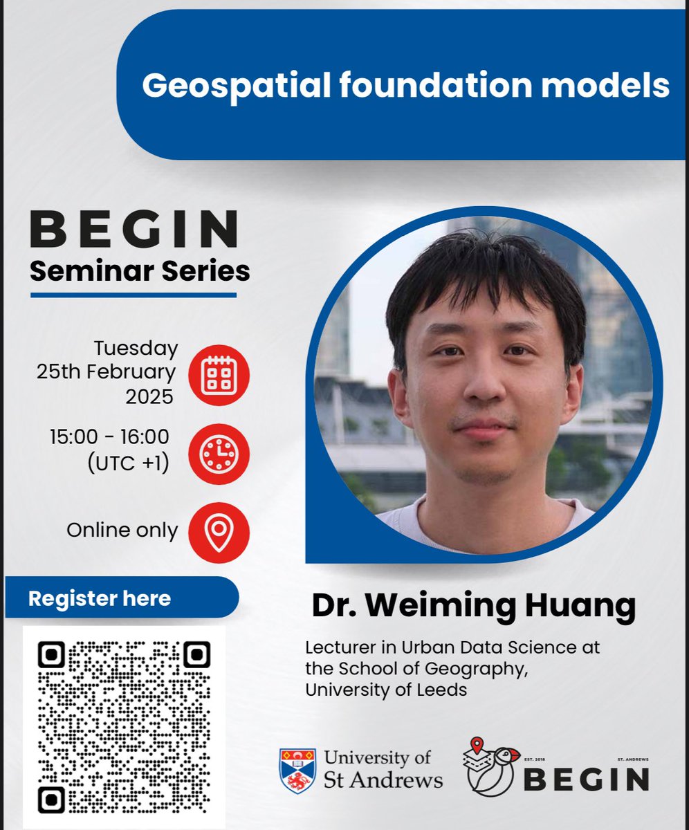
🚀Our first @BEGIN_StAndrews Seminar of 2025 is happening next week! 🗓 Feb 25 | 15:00 | Online (Teams)🎙 Dr. Weiming Huang (Univ. of Leeds) will talk about Geospatial Foundation Models—how large-scale models can transform geospatial analysis. #GeospatialAI #FoundationModels


We're excited to share that Todd Surdey joins Maxar Intelligence as SVP & GM of Enterprise, bringing decades of experience from Palo Alto Networks, VMware, Google, and Salesforce. #Maxar #GeospatialAI #Leadership


𝗛𝗔𝗣𝗣𝗬 𝗜𝗡𝗗𝗘𝗣𝗘𝗡𝗗𝗘𝗡𝗖𝗘 𝗗𝗔𝗬! @blacksharkai wishes all our friends, colleagues, and clients in the U.S. a fun-filled and memorable 4th of July. Enjoy the celebrations, fireworks, and time with loved ones! #IndependenceDay #4thofJuly #GeospatialAI


✨ A huge thanks to everyone who attended our meetup yesterday! Special thanks to @Hivemapper for joining us and Silas Toms for revitalizing the GeoMeetup group. See you at the next event! #Meetup #GeospatialAI #GeospatialData

Planet Labs (NYSE: PL) stock rises as Pelican-5 and Pelican-6 extend edge-AI capabilities in orbit business-news-today.com/planet-labs-ny… #PlanetLabs #SatelliteImaging #GeospatialAI #PelicanSatellite #EarthObservation #SpaceTech #NVIDIAJetson #RemoteSensing #SuperDoves #SpaceXLaunch #SpaceX
In 2025, AI is transforming geospatial workflows! At TopoDOT, our AI tools enhance efficiency and quality. We’re excited to continue to leverage AI to streamline your work! #GeospatialAI #TopoDOT #AIInEngineering #PointCloudProcessing
Each dimension of Google Earth AI’s Population Dynamics Foundations embeddings shows unique patterns by ZIP code. 🏘️ See how GeoAI data reveal hidden insights: research.google/blog/google-ea… #Geoawesome #GeospatialAI #DataViz

This empowers policymakers, urban planners, environmental scientists, and organizations to make smarter, faster, and more accurate decisions. #GeoAI #SpatialAnalysis #GeospatialAI #GIS #DataScience #MoranI #AI #MachineLearning #SatelliteData #SpatialPatterns #SDSSN

We just launched BhumiAI on product hunt - an AI tool that lets you analyse any location in the world instantly, for FREE. Investors, agents, analysts… this one’s for you. Link - shorturl.at/TPpxq #AI #RealEstateTech #GeospatialAI


#NianticSpatial, #GeospatialAI, #SpatialComputing, #VPS, #Scaniverse, #ComputerVision, #3DMapping, #Augmentedreality, #GaussianSplatting, #LLMtoLGM, #AI
#NianticSpatial, #GeospatialAI, #SpatialComputing, #VPS, #Scaniverse, #ComputerVision, #3DMapping, #Augmentedreality, #GaussianSplatting, #LLMtoLGM, #AI

Building GeoLLM has been an incredible journey -- applying AI and geospatial tech to solve real-world challenges. I’m excited to explore how this work can evolve in real-world products and collaborations! 🚀 #AI #GeoLLM #GeospatialAI #LLM #RAG #RemoteSensing #Python #NextJS
Google | AI | Map गुगल बनणार संकटसमयीचा साथीदार #GoogleEarthAI #DisasterManagement #GeospatialAI #GoogleGemini #FloodAlert #TechNewsMarathi #Kharesangen #ndtvmarathi @shreerangkhare

AI isn’t just learning from text — it’s learning from the world itself. Fusing geospatial data with reasoning models turns maps into decision engines for energy, logistics, and disaster response. Space is becoming a new data layer. #GeospatialAI #EdgeAI #AIforGood

Connecting weather, population, and satellite data unlocks massive potential for climate, infrastructure, and resource planning. 👏 #AI #GeospatialAI #Gemini

Google Earth AI, our collection of geospatial AI models and datasets, is expanding globally and adding new capabilities. That includes Geospatial Reasoning, powered by Gemini, which automatically connects different Earth AI models - like weather forecasts, population maps +…

🚀 Satellite Annotation isn’t just about drawing polygons — it’s about precision at planetary scale 🌍 At @JThetaAI, we’re redefining geospatial labeling with: ⚙️ Cloud-optimized speed 🗺️ Intelligent tiling 🌐 Smarter dataset management 👉 jtheta.ai #GeospatialAI


🚀 New Google Earth AI Updates 2025! 🌍 Discover Geospatial Reasoning & Gemini AI features for disaster response, environmental monitoring & more. Watch now: youtu.be/SN8LUBSJzeY?si… #GoogleEarthAI #GeospatialAI #GeminiAI #AIUpdates2025 🌎💡
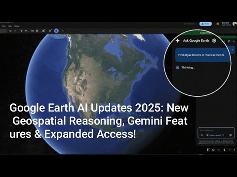
youtube.com
YouTube
Google Earth AI Updates 2025: New Geospatial Reasoning, Gemini...
In Geospatial AI, speed and precision aren’t trade-offs — they’re the foundation. We’re building tools to make annotation as scalable as Earth itself. 🌐 🔗 Learn more → jtheta.ai #GeospatialAI #RemoteSensing #GIS #Mapping #DigitalTwin #3DMapping #SmartCities

Impressed by the real-world impact of Talus Labs' work in geospatial intelligence. Their project using AI to analyze satellite imagery for disaster response and infrastructure monitoring is a powerful example of technology for good. @Talus_labs #GeospatialAI #TechForGood
本日、@KojiPro2015 ご主催の "Beyond The Strand" にて、KOJIMA PRODUCTIONS と#NianticSpatial は技術提供のパートナーシップを発表しました。 詳しくは、ブログをご覧ください。 nianticspatial.com/blog/kojima-pr… #GeospatialAI #KojimaProductions #KJP10th
🚀 GeoAI v0.16.0 is here! Train image segmentation models and instantly visualize performance metrics with a single line of Python code. 💡 📦 GitHub: github.com/opengeos/geoai 📓 Example notebook: opengeoai.org/examples/train… #GeoAI #DeepLearning #GeospatialAI #Python #OpenSource…

Partnering with 3D Tricks, where geospatial intelligence meets innovation. 🌍 Led by Eng. Ahmed Gamal, they’re shaping the future of 3D Pointcloud & geospatial tech. 👉 wa.me/201500002077 #Evyx #3DTricks #GeospatialAI #DigitalTwin #BIM #GIS #SaudiArabia #DigitalMarketing

With #geospatialAI agents and #intelligentGIS automation driving insight, we’re moving beyond traditional workflows to create systems that are adaptive, scalable, and built for the future of #infrastructure management. Register for this webinar: hubs.ly/Q03Nn29R0
Natural resources management is getting an #AI upgrade. 🚀From governance to Smart Governance with #GeospatialAI Agents. Discover how AI is transforming: Real Estate Reg, Spatial Planning, Farmland Protection, and Govt. Services. Read the full story: bit.ly/4nedRBc
Students from Islamabad’s Institute of Space Technology, Ahmed Iqbal and Hanzila Bin Younas, turned their final-year project into an award-winning innovation. #GeoGemma #GeospatialAI #ISTPakistan #APACChallenge2025
📢 [𝐍𝐄𝐖𝐒] - @SafranFedSys launches HyperReveal, a U.S.-based #GeospatialAI platform, at #GEOINT2025. Built for defense + intel ops, HyperReveal enables: 🔍 Object & pattern detection 🛰️ Persistent ISR ⚡️ Real-time decision-making ➡️ Booth 2321 📰 PR: safranfederalsystems.com/media-and-news…
#GeospatialAI, combining artificial intelligence (#AI) with geographic information systems (GIS), is transforming our understanding of the planet. By automating data processing and uncovering hidden patterns in vast geospatial datasets, Geospatial AI revolutionizes various…

IBM’s new #geospatialAI model on @huggingface has been fine-tuned to be utilized for use cases such as tracking deforestation, predicting crop yields, and monitoring greenhouse gases. Find out more here ow.ly/3yUu50PF2Wc


Google AI unveils Geospatial Reasoning, a transformative research initiative using generative AI (Gemini) to unlock world insights! This tool combines advanced models to answer complex questions with plans and visuals, reshaping industries. #AI #GeospatialAI #GoogleAI


On #WorldLiteracyDay, Deepspatial celebrates education with edskCalibre, our GeoAI-powered platform driving data-driven solutions for accessible and equitable learning. 📚🌍 #edskCalibre #GeoSpatialAI #Deepspatial #EducationForAll $DSAI $DSAIF $DSAI.CN

On #WorldFirstAidDay, Deepspatial highlights the power of GeoAI in disaster management. Our solutions help governments and communities take swift, data-driven action to save lives and build resilience. 🌍🚑 #GeoSpatialAI #DisasterManagement #SafetyFirst $DSAI $DSAIF $DSAI.CN

On the blessed occasion of Milad-un-Nabi, Deepspatial wishes everyone peace, compassion, and unity. May we continue to lead with empathy and innovation, driving impactful outcomes through GeoAI. 🌍 #MiladUnNabi #EidMubarak #GeoSpatialAI #Innovation #Unity $DSAI $DSAIF $DSAI.CN


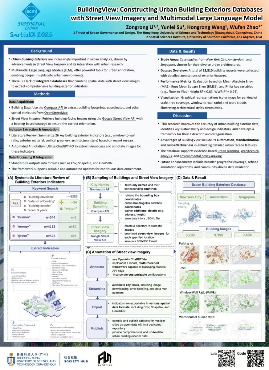
Thrilled our paper was accepted to ACM SpatialDI 2025! We present BuildingView — using LLMs + Google Street View to auto-annotate building façades for scalable urban analysis. 📄 arxiv.org/abs/2409.19527 Big thanks, AI4City Lab + Prof. Wufan Zhao #UrbanAI #GeospatialAI
We're excited to share that Todd Surdey joins Maxar Intelligence as SVP & GM of Enterprise, bringing decades of experience from Palo Alto Networks, VMware, Google, and Salesforce. #Maxar #GeospatialAI #Leadership
✨ A huge thanks to everyone who attended our meetup yesterday! Special thanks to @Hivemapper for joining us and Silas Toms for revitalizing the GeoMeetup group. See you at the next event! #Meetup #GeospatialAI #GeospatialData

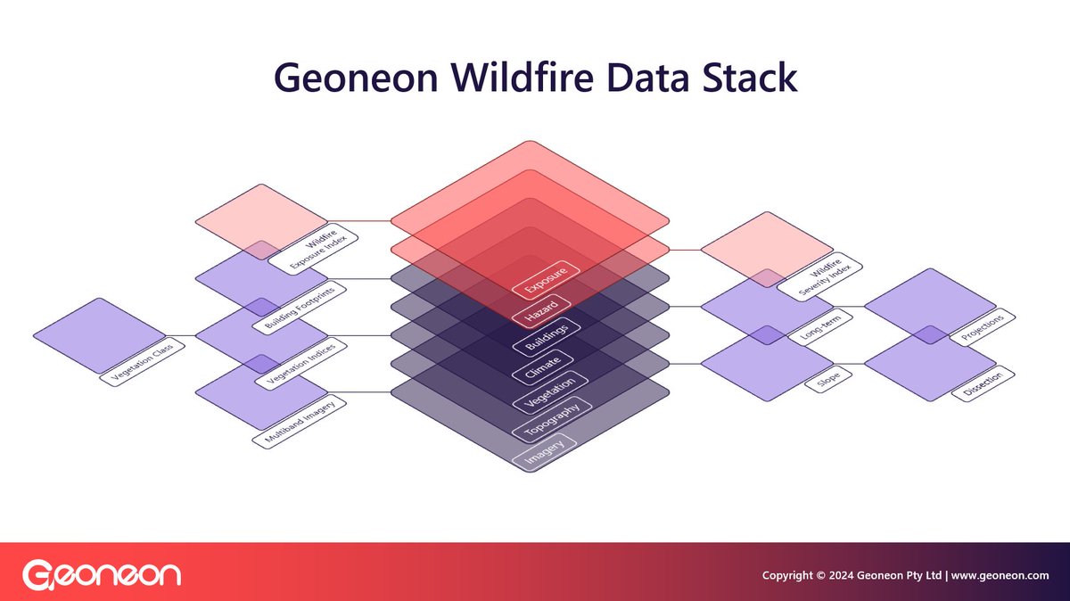
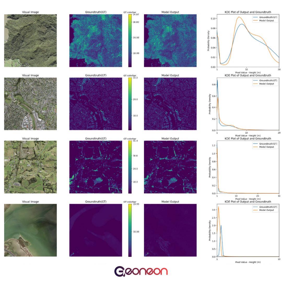
🔥 Geoneon Wildfire Data Stack integrates buildings, vegetation, climate, topography, & satellite imagery to model wildfire risks. It powers our Severity & Exposure Indices, helping decision-makers plan & protect. 🌿🏘️ #Geoneon #WildfireRisk #GeospatialAI #ClimateTech
🌍 Geoneon’s Vegetation Mapping: Accuracy You Can Trust 🌍 We test our models on areas never used for training to ensure top accuracy. With hundreds of tests, we compare results to real-world data. Reliable data, tested regularly. 🔍 #Geoneon #VegetationMapping #GeospatialAI

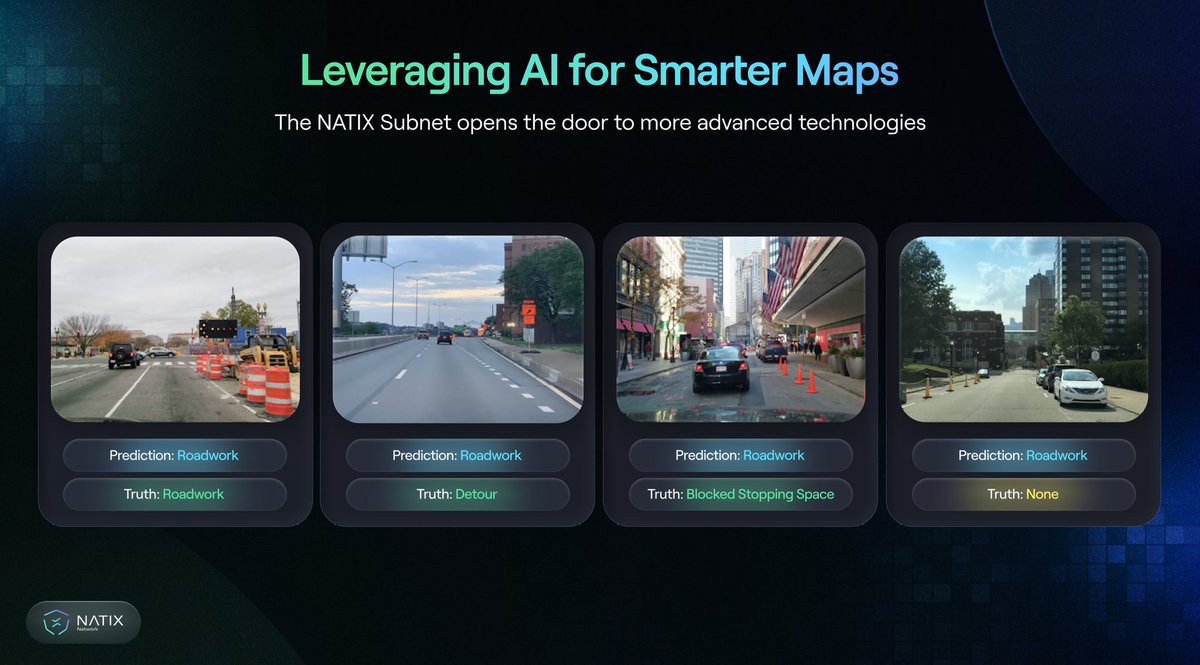
🔍 NATIX uses AI + blockchain to turn video streams into metadata. That means your phone can help map the world — privately and securely. #NATIXNetwork #GeospatialAI #DriveAndEarn @NATIXNetwork

Unlock intelligent mapping and data insights with Spatialox’s Geospatial AI-powered GIS solutions. #GeospatialAI #GISSolutions #IntelligentMapping #DataInsights #TechInnovation #SpatialData #MappingTechnology #BusinessIntelligence

Something went wrong.
Something went wrong.
United States Trends
- 1. Florida 104K posts
- 2. Texas 178K posts
- 3. Ohio State 28.9K posts
- 4. Ohio State 28.9K posts
- 5. #SmallBusinessSaturday 2,499 posts
- 6. Kentucky 15.1K posts
- 7. Kentucky 15.1K posts
- 8. Buckeyes 5,475 posts
- 9. Go Blue 7,030 posts
- 10. Leeds 27.4K posts
- 11. Go Bucks 2,412 posts
- 12. The Game 1.04M posts
- 13. Saban 6,003 posts
- 14. Sunderland 22.4K posts
- 15. Foden 11.6K posts
- 16. Grade 3 3,013 posts
- 17. Good Saturday 36.7K posts
- 18. Tyler Adams 3,279 posts
- 19. #SaturdayVibes 4,199 posts
- 20. Gameday 31K posts