#hurricane search results

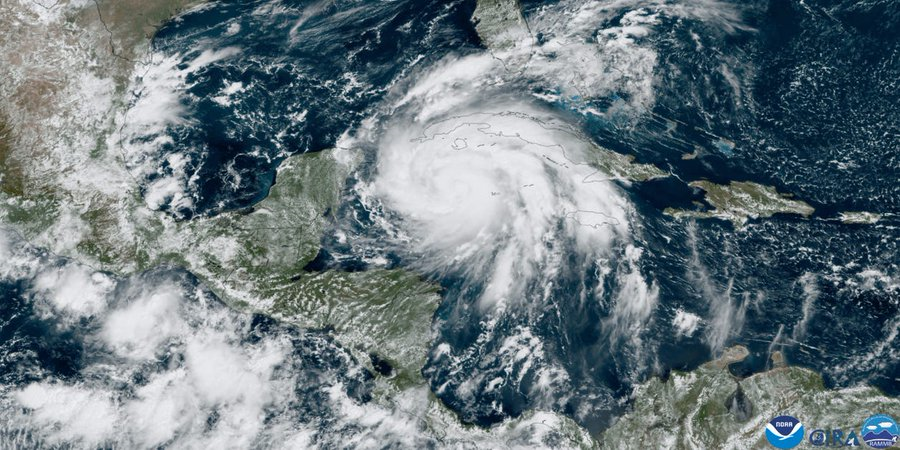
NEW! Here's Cat-5 #Hurricane #MELISSA's #Jamaica landfall as captured on Cayman Islands radar. These images did not exist until a few days ago, when @fathercay & team at CINWS processed the data. This is at the very edge of the radar range—the radar site is over 200 mi away—&

TROPIC SHIFT 🌊: The emergence of El Nino is becoming more likely by the day, and the weather pattern will play a major role in determining the outcome of hurricane season. Here's how it could impact the Eastern Pacific. #tropics #hurricane #summer #pacific #foxweather

New: Melissa has been officially retired by the World Meteorological Organization today due to the destruction #Hurricane #Melissa caused in #Jamaica in October. It is being replaced by the name Molly on the list of rotating names. Image via Copernicus Sentinel-2


The WMO Hurricane Committee has retired the name Melissa because of the destruction it caused in the Caribbean in 2025. It will be replaced by Molly on the list of rotating names. bit.ly/4shPDrQ

A reminder, that I predicted the landfall of #Hurricane #Beryl in Texas much better than @NHC_Atlantic did By that time, NHC had been aware of my skill, likely for a full year already I had contacted them with an offer of cooperation, but I was rejected The refusal of NHC to
Performance of comparable forecast points within 24 hours of landfall of #Hurricane #Beryl in Texas - in 11/60 cases, I was more erroneous than NHC - in 26/60 cases, I was less erroneous than NHC

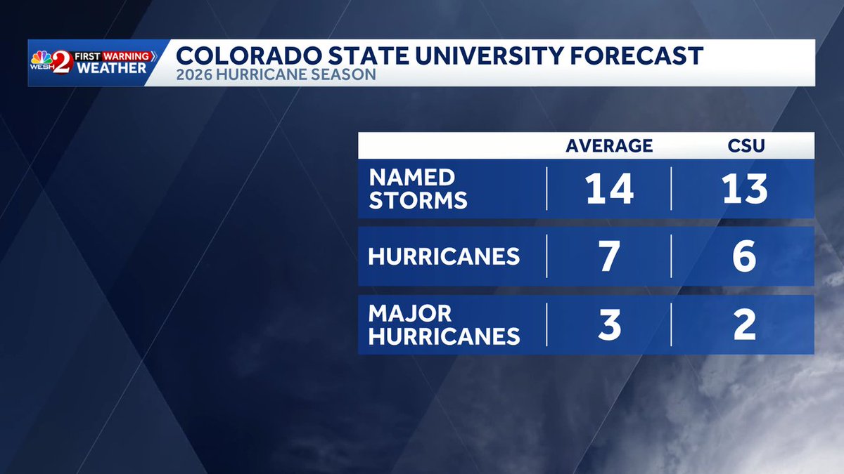
The primary reason for CSU's somewhat below-normal Atlantic #hurricane season forecast is a high likelihood for a robust #ElNino. El Nino typically decreases Atlantic hurricane activity via increases in Caribbean/tropical Atlantic vertical wind shear.


ICEYE joins the 48th Hurricane Committee in Mexico City, showcasing Hurricane Melissa response and how SAR data enabled rapid impact assessment and disaster decisions. To learn more or to set up a meeting with us at the event, contact us here: hubs.li/Q044XLg_0 #Hurricane

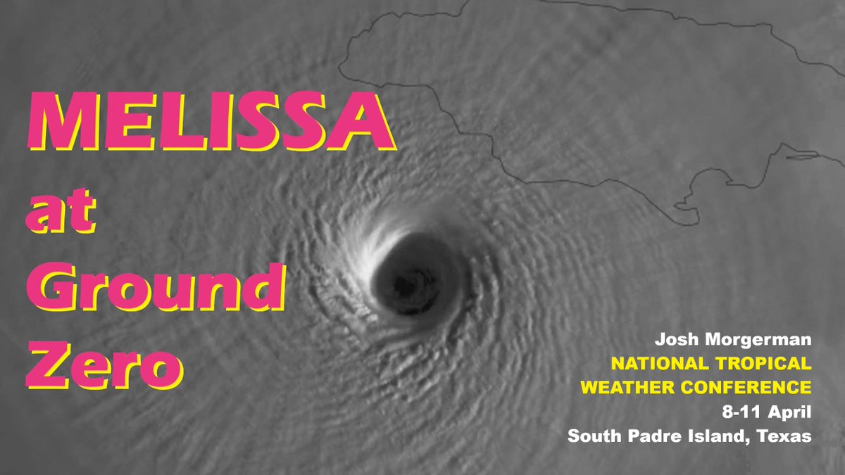
Who's attending National Hurricane Conference? Come to #Hurricane #MELISSA Workshop: 10:30 am Wednesday in Salon 11 (2nd floor). National Hurricane Center, Aircraft Operations Center, & I will analyze this incredible storm from multiple angles & perspectives. Mine? Ground Zero.


#HurricaneSeason2026 ... Are You READY!!! 39 Days Away...GET #Hurricane & #Tornado READY ... Call 800 679 0369 #BBB > New #Roofs Hurricane Impact #Windows #Doors #StormShutters #ScreenPoolEnclosures Super High Efficiency Central A/C, #BlueRoofs remodelsouthflorida.com


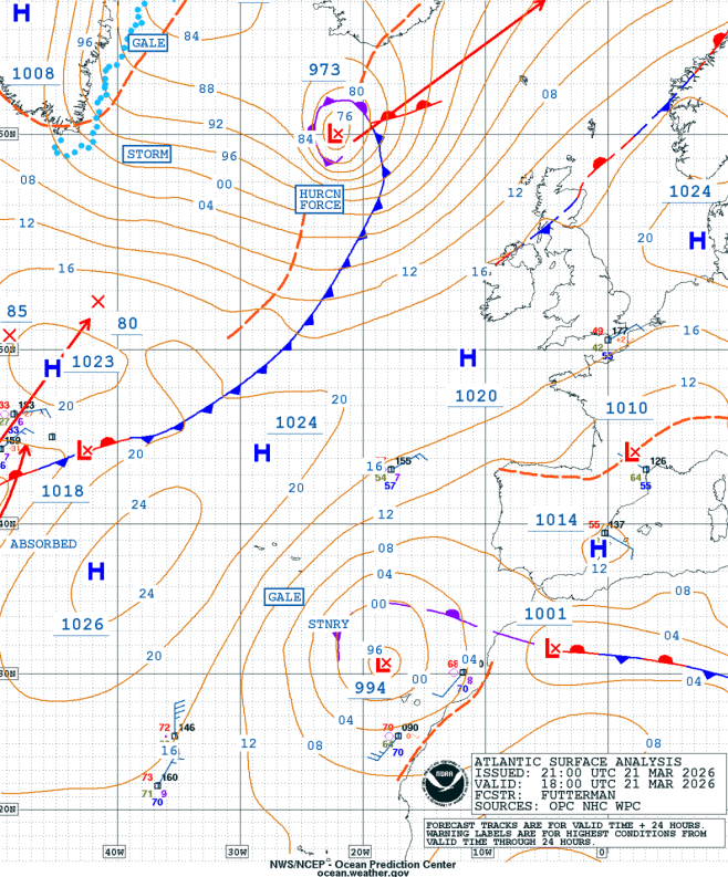
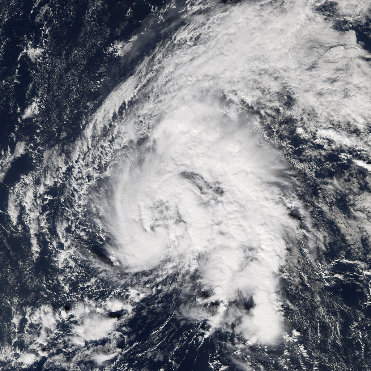
It is likely that the non-frontal area of low pressure has developed into a subtropical cyclone. When exactly? It's a bit hard to tell for sure. Personally, I'm designating it at 23rd 00z as by then it has been sustaining -50C for 12 hours. #wx #hurricane #arthur
#Arthur is that you? A non-frontal area of low pressure located between the Canary and Azores Islands is developing some decent convection and could briefly form into a subtropical cyclone before conditions become unfavorable within ~24 hours @AndyHazelton @WeathermanAAA_

HURRICANE SEASON 🌀: Director of the National Hurricane Conference Michael Brennan joins FOX Weather to talk about the recent gathering of thousands of experts to exchange ideas, including how to best keep people safe. #hurricaneseason #Hurricane #extremeweather #SevereWx
Watch the full lifecycle of arguably the most impressive #blizzard in modern history. Nearly 40" of snow, equivalent pressure (966mb) to a category 3 #hurricane, wind gusts to 83 mph. And it’s not quite over yet. #snow #blizzard2026 #providence
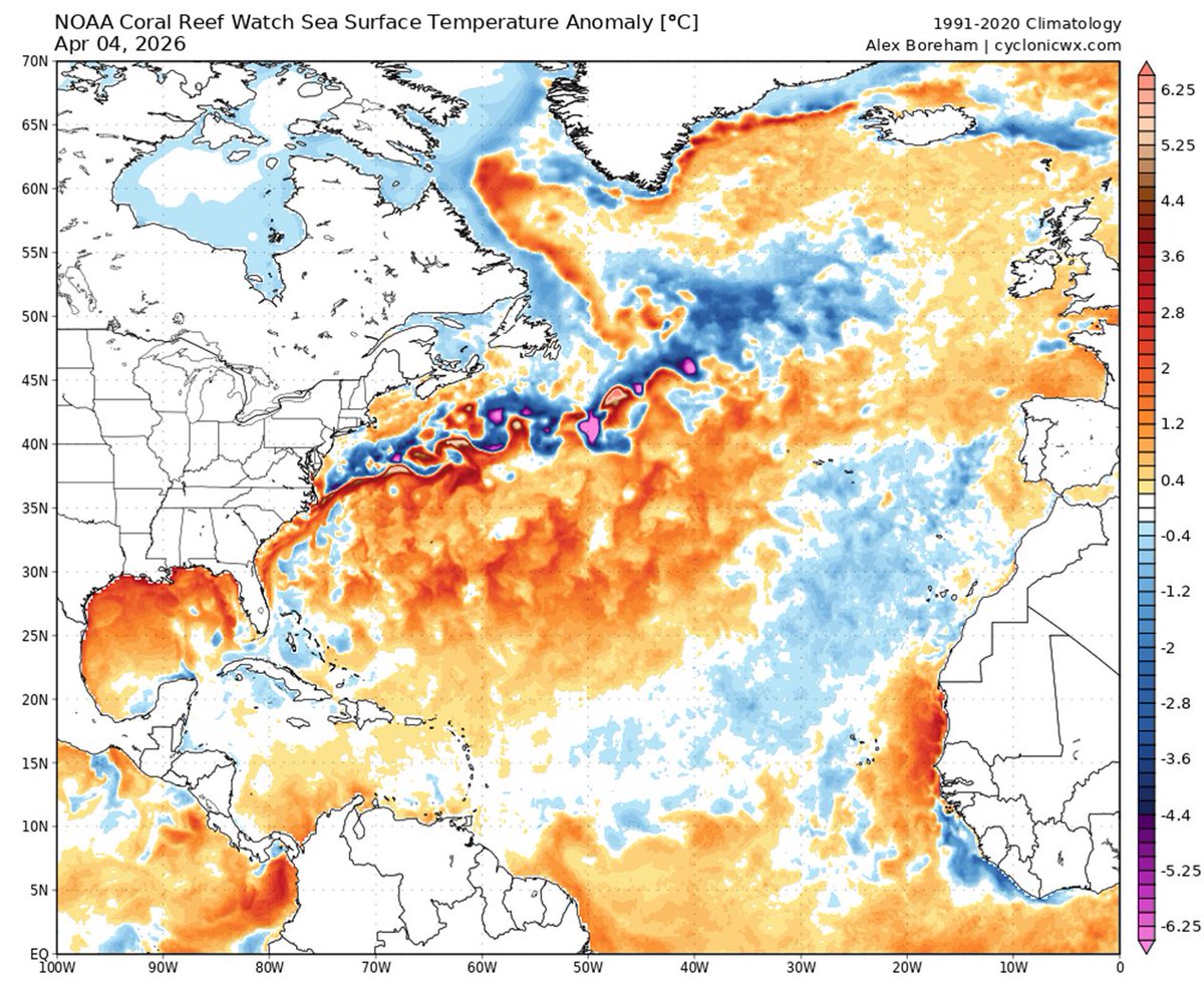
The Caribbean is slightly warmer than normal, while the eastern and central tropical Atlantic are slightly cooler than normal. This pattern of Atlantic sea surface temperatures provides mixed signals regarding the potential for an above- or below-normal Atlantic #hurricane season
#HurricaneSeason2026 ... Are You READY!!! 39 Days Away...GET #Hurricane & #Tornado READY ... Call 800 679 0369 #BBB > New #Roofs Hurricane Impact #Windows #Doors #StormShutters #ScreenPoolEnclosures Super High Efficiency Central A/C, #BlueRoofs remodelsouthflorida.com

Beneficial rain moving into the western panhandle tonight. Enjoy it over there!
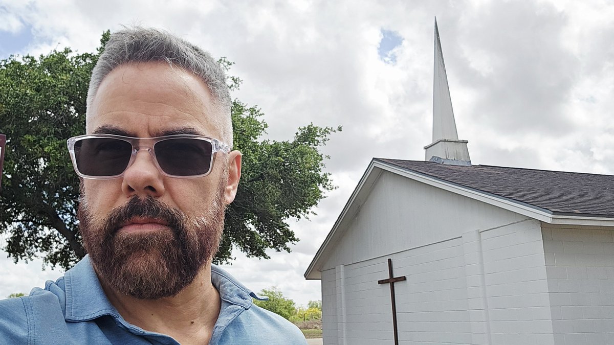
Driving through South Texas. My annual pilgrimage to the li'l roadside church in Riviera where I rode out my first Gulf #hurricane in 1999. I'd chased before, but this is where the obsession really started. 27 years later, I remember only random details: the roar of the winds,
Since folks keep asking: #Cuba is extremely #hurricane-prone. Just since 2000, they've had 16 'canes, including rare Cat 5 (IRMA2017) & five Cat 4s. In GUSTAV2008, Cuba measured sustained 135 knots with gust to 184—one of highest official wind readings ever recorded in a 'cane.
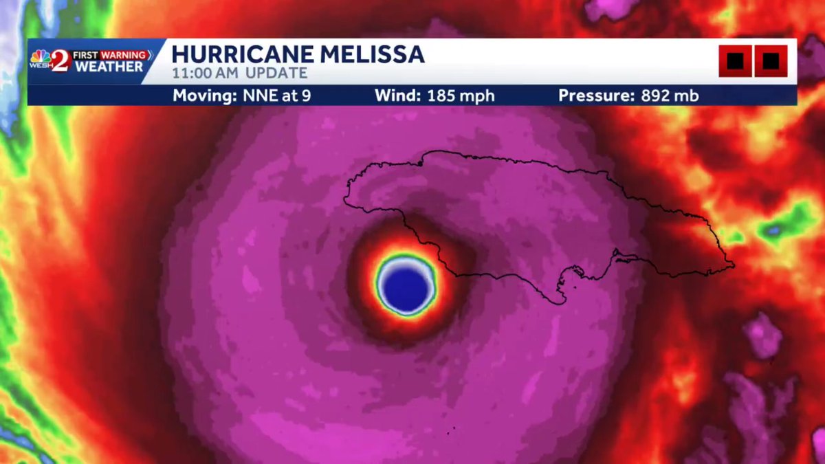
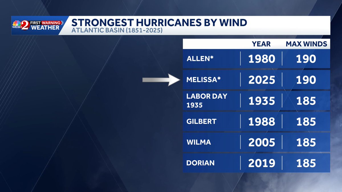
Breaking: Hurricane #Melissa now tied for the strongest storm ever in the Atlantic with winds upgraded to 190 mph winds. Tied with #Hurricane Allen in 1980! New info comes from NHC post season analysis.

Here's #Cyclone #NARELLE's *epic* odyssey encircling the Australian continent. It made landfall as a severe tropical cyclone (what we call a #hurricane) in 3 states: Queensland, Northern Territory, & Western #Australia—only the 2nd known instance of this. (Other: INGRID 2005.)

CSU's four analogs for the 2026 Atlantic seasonal #hurricane forecast are: 2006, 2009, 2015 and 2023. Analogs are selected based on robust #ElNino and above-normal sea surface temperatures during August-October.


Occasionally they let me out of the building and here's proof! Working on a story for this year's upcoming hurricane season. Can't wait to share the story with you June 1st! #wesh #weather #hurricane #special

Earlier today the @NHC_Atlantic revealed that the winds with #Melissa were at 190 mph after post analysis making it tied with #Allen for strongest winds in a hurricane! #hurricane #research #nhc

Good Night #Florida ... #HurricaneSeason2026 ... Are You READY!!! 39 Days Away...GET #Hurricane & #Tornado READY ... Call 800 679 0369 #BBB > New #Roofs Hurricane Impact #Windows #Doors #StormShutters #ScreenPoolEnclosures Super High Efficiency Central A/C, #BlueRoofs

#HurricaneSeason2026 ... Are You READY!!! 39 Days Away...GET #Hurricane & #Tornado READY ... Call 800 679 0369 #BBB > New #Roofs Hurricane Impact #Windows #Doors #StormShutters #ScreenPoolEnclosures Super High Efficiency Central A/C, #BlueRoofs remodelsouthflorida.com

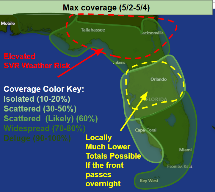
🌀 We’d love to see you at the Hurricane Awareness Tour next week! Stop by, ask questions, tour the hurricane hunter planes, and learn how to stay safe this hurricane season. 📅 May 5 | 📍 Mobile International Airport weather.gov/mob/2026HAT

#HurricaneSeason2026 ... Are You READY!!! 39 Days Away...GET #Hurricane & #Tornado READY ... Call 800 679 0369 #BBB > New #Roofs Hurricane Impact #Windows #Doors #StormShutters #ScreenPoolEnclosures Super High Efficiency Central A/C, #BlueRoofs remodelsouthflorida.com
Beneficial rain moving into the western panhandle tonight. Enjoy it over there!
#HurricaneSeason2026 ... Are You READY!!! 39 Days Away...GET #Hurricane & #Tornado READY ... Call 800 679 0369 #BBB > New #Roofs Hurricane Impact #Windows #Doors #StormShutters #ScreenPoolEnclosures Super High Efficiency Central A/C, #BlueRoofs remodelsouthflorida.com
#HurricaneSeason2026 ... Are You READY!!! 39 Days Away...GET #Hurricane & #Tornado READY ... Call 800 679 0369 #BBB > New #Roofs Hurricane Impact #Windows #Doors #StormShutters #ScreenPoolEnclosures Super High Efficiency Central A/C, #BlueRoofs remodelsouthflorida.com
4/29 at 11:30PM: There is a medium (30-50%) chance of dense fog across interior SWFL through daybreak on Thursday, mainly between the hours of 2-9 AM. Further east, smoke from the HWY 41 wildfire may drift into the Miami Metro bringing reduced air quality & lower visibilities.

#HurricaneSeason2026 ... Are You READY!!! 39 Days Away...GET #Hurricane & #Tornado READY ... Call 800 679 0369 #BBB > New #Roofs Hurricane Impact #Windows #Doors #StormShutters #ScreenPoolEnclosures Super High Efficiency Central A/C, #BlueRoofs remodelsouthflorida.com
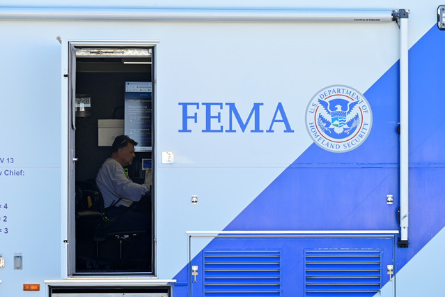

FEMA’s disaster relief fund hits red zone ahead of hurricane season offthepress.com/femas-disaster…

#HurricaneSeason2026 ... Are You READY!!! 39 Days Away...GET #Hurricane & #Tornado READY ... Call 800 679 0369 #BBB > New #Roofs Hurricane Impact #Windows #Doors #StormShutters #ScreenPoolEnclosures Super High Efficiency Central A/C, #BlueRoofs remodelsouthflorida.com

EXCLUSIVE: FEMA officially enters a financial danger zone with the start of hurricane season just weeks away. cbsn.ws/42or9m5

#HurricaneSeason2026 ... Are You READY!!! 39 Days Away...GET #Hurricane & #Tornado READY ... Call 800 679 0369 #BBB > New #Roofs Hurricane Impact #Windows #Doors #StormShutters #ScreenPoolEnclosures Super High Efficiency Central A/C, #BlueRoofs remodelsouthflorida.com

#HurricaneSeason2026 ... Are You READY!!! 39 Days Away...GET #Hurricane & #Tornado READY ... Call 800 679 0369 #BBB > New #Roofs Hurricane Impact #Windows #Doors #StormShutters #ScreenPoolEnclosures Super High Efficiency Central A/C, #BlueRoofs remodelsouthflorida.com

Fantastic short story! 3 men caught in a #hurricane are at the mercy of Mother Nature! #suspense #thriller #KU #quickread geni.us/Blow Only 99¢!

#HurricaneSeason2026 ... Are You READY!!! 39 Days Away...GET #Hurricane & #Tornado READY ... Call 800 679 0369 #BBB > New #Roofs Hurricane Impact #Windows #Doors #StormShutters #ScreenPoolEnclosures Super High Efficiency Central A/C, #BlueRoofs remodelsouthflorida.com

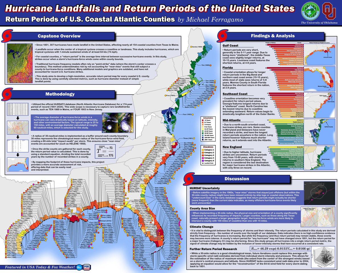
As college draws to an end, I’ve been spending the last week on my capstone poster — and I just had to share it. This is so incredibly awesome.
#HurricaneSeason2026 ... Are You READY!!! 39 Days Away...GET #Hurricane & #Tornado READY ... Call 800 679 0369 #BBB > New #Roofs Hurricane Impact #Windows #Doors #StormShutters #ScreenPoolEnclosures Super High Efficiency Central A/C, #BlueRoofs remodelsouthflorida.com

Come join me LIVE ON AIR in 2 hours at 10 PM ET/ 7 PM PT for episode 3 of Turning Point! Get ready to learn about the deadliest hurricanes in the USA! #Hurricane youtube.com/watch?v=fq7QIj…

youtube.com
YouTube
A.C.E. (ALEX CARDINALE ENTERTAINMENT)
#HurricaneSeason2026 ... Are You READY!!! 39 Days Away...GET #Hurricane & #Tornado READY ... Call 800 679 0369 #BBB > New #Roofs Hurricane Impact #Windows #Doors #StormShutters #ScreenPoolEnclosures Super High Efficiency Central A/C, #BlueRoofs remodelsouthflorida.com
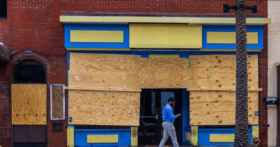
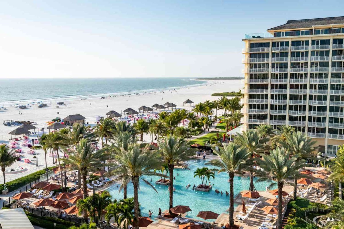
It’s been over 100 years since a hurricane struck Tampa, and 34 since Miami suffered a direct hit. Some forecasters consider both cities “overdue.” It’s never too early to prepare for hurricane season. @FloridaDBPR @ABCofFL @AGC_FEC @flroof @FHBAOfficial floridatoday.com/story/news/wea…

#HurricaneSeason2026 ... Are You READY!!! 39 Days Away...GET #Hurricane & #Tornado READY ... Call 800 679 0369 #BBB > New #Roofs Hurricane Impact #Windows #Doors #StormShutters #ScreenPoolEnclosures Super High Efficiency Central A/C, #BlueRoofs remodelsouthflorida.com
#HurricaneSeason2026 ... Are You READY!!! 39 Days Away...GET #Hurricane & #Tornado READY ... Call 800 679 0369 #BBB > New #Roofs Hurricane Impact #Windows #Doors #StormShutters #ScreenPoolEnclosures Super High Efficiency Central A/C, #BlueRoofs remodelsouthflorida.com
#HurricaneSeason2026 ... Are You READY!!! 39 Days Away...GET #Hurricane & #Tornado READY ... Call 800 679 0369 #BBB > New #Roofs Hurricane Impact #Windows #Doors #StormShutters #ScreenPoolEnclosures Super High Efficiency Central A/C, #BlueRoofs remodelsouthflorida.com

Best case scenario appears to be in progress as severe thunderstorms are weakening while BENEFICIAL RAIN continues to spread across the region. This is excellent news! ⛈️

#HurricaneSeason2026 ... Are You READY!!! 39 Days Away...GET #Hurricane & #Tornado READY ... Call 800 679 0369 #BBB > New #Roofs Hurricane Impact #Windows #Doors #StormShutters #ScreenPoolEnclosures Super High Efficiency Central A/C, #BlueRoofs remodelsouthflorida.com
#HurricaneSeason2026 ... Are You READY!!! 39 Days Away...GET #Hurricane & #Tornado READY ... Call 800 679 0369 #BBB > New #Roofs Hurricane Impact #Windows #Doors #StormShutters #ScreenPoolEnclosures Super High Efficiency Central A/C, #BlueRoofs remodelsouthflorida.com

Well the Eastern Pacific Hurricane Season starts May 15th for a reason. You won't find this one on the NHC homepage, but the CPC has pinned a potential future area with a low chance of development in Mid-May ahead. Water temps are above average currently in the region. All's

#HurricaneSeason2026 ... Are You READY!!! 39 Days Away...GET #Hurricane & #Tornado READY ... Call 800 679 0369 #BBB > New #Roofs Hurricane Impact #Windows #Doors #StormShutters #ScreenPoolEnclosures Super High Efficiency Central A/C, #BlueRoofs remodelsouthflorida.com


#HurricaneSeason2026 ... Are You READY!!! 39 Days Away...GET #Hurricane & #Tornado READY ... Call 800 679 0369 #BBB > New #Roofs Hurricane Impact #Windows #Doors #StormShutters #ScreenPoolEnclosures Super High Efficiency Central A/C, #BlueRoofs remodelsouthflorida.com
FEMA’s disaster relief fund hits red zone ahead of hurricane season offthepress.com/femas-disaster…
Fantastic short story! 3 men caught in a #hurricane are at the mercy of Mother Nature! #suspense #thriller #KU #quickread geni.us/Blow Only 99¢!
Occasionally they let me out of the building and here's proof! Working on a story for this year's upcoming hurricane season. Can't wait to share the story with you June 1st! #wesh #weather #hurricane #special
#HurricaneSeason2026 ... Are You READY!!! 39 Days Away...GET #Hurricane & #Tornado READY ... Call 800 679 0369 #BBB > New #Roofs Hurricane Impact #Windows #Doors #StormShutters #ScreenPoolEnclosures Super High Efficiency Central A/C, #BlueRoofs remodelsouthflorida.com
EXCLUSIVE: FEMA officially enters a financial danger zone with the start of hurricane season just weeks away. cbsn.ws/42or9m5
Good Night #Florida ... #HurricaneSeason2026 ... Are You READY!!! 39 Days Away...GET #Hurricane & #Tornado READY ... Call 800 679 0369 #BBB > New #Roofs Hurricane Impact #Windows #Doors #StormShutters #ScreenPoolEnclosures Super High Efficiency Central A/C, #BlueRoofs
The primary reason for CSU's somewhat below-normal Atlantic #hurricane season forecast is a high likelihood for a robust #ElNino. El Nino typically decreases Atlantic hurricane activity via increases in Caribbean/tropical Atlantic vertical wind shear.
#HurricaneSeason2026 ... Are You READY!!! 39 Days Away...GET #Hurricane & #Tornado READY ... Call 800 679 0369 #BBB > New #Roofs Hurricane Impact #Windows #Doors #StormShutters #ScreenPoolEnclosures Super High Efficiency Central A/C, #BlueRoofs remodelsouthflorida.com
It’s been over 100 years since a hurricane struck Tampa, and 34 since Miami suffered a direct hit. Some forecasters consider both cities “overdue.” It’s never too early to prepare for hurricane season. @FloridaDBPR @ABCofFL @AGC_FEC @flroof @FHBAOfficial floridatoday.com/story/news/wea…
CSU's four analogs for the 2026 Atlantic seasonal #hurricane forecast are: 2006, 2009, 2015 and 2023. Analogs are selected based on robust #ElNino and above-normal sea surface temperatures during August-October.
Good Afternoon #Florida ... #HurricaneSeason2026 ... Are You READY!!! 39 Days Away...GET #Hurricane & #Tornado READY ... Call 800 679 0369 #BBB > New #Roofs Hurricane Impact #Windows #Doors #StormShutters #ScreenPoolEnclosures Super High Efficiency Central A/C, #BlueRoofs
ICEYE joins the 48th Hurricane Committee in Mexico City, showcasing Hurricane Melissa response and how SAR data enabled rapid impact assessment and disaster decisions. To learn more or to set up a meeting with us at the event, contact us here: hubs.li/Q044XLg_0 #Hurricane
The Caribbean is slightly warmer than normal, while the eastern and central tropical Atlantic are slightly cooler than normal. This pattern of Atlantic sea surface temperatures provides mixed signals regarding the potential for an above- or below-normal Atlantic #hurricane season
Who's going to National Tropical Weather Conference? It's 8-11 April on South Padre Island, TX. This is my FAVORITE #hurricane conference. My presentation this year is gonna be intense: Hurricane MELISSA at Ground Zero. BE THERE. & come say hi. REGISTER: hurricanecenterlive.com
20 years ago today: Tropical Storm Zeta formed 800 miles west-northwest of Cape Verde, and was the final storm of the historic 2005 Atlantic #hurricane season. Zeta was the second Atlantic tropical cyclone on record to exist in two calendar years, dissipating January 7th, 2006.


"If it’s not right, I’m gonna fight." - Doris B. When #Hurricane Beryl left 2.3 million #Texans in the dark in 2024, Doris's power stayed on, and her neighbors stayed safe all thanks to #solar! ☀️ Help fuel the fight for everyone's #energy rights. bit.ly/44xCly9

Stills from a shoot last week—for a new series of video shorts. The concept: epic #hurricane tales in tight, 7-minute episodes. Working title: #HurricaneChronicles. These stills are from the IDA episode. Imagine what I brought for MELISSA. Coming soon to @WeatherNation.

Here's #Cyclone #NARELLE's *epic* odyssey encircling the Australian continent. It made landfall as a severe tropical cyclone (what we call a #hurricane) in 3 states: Queensland, Northern Territory, & Western #Australia—only the 2nd known instance of this. (Other: INGRID 2005.)
Colorado State University released its hurricane forecast this year and the numbers are slightly below average. Coming up on @wesh2 at 4pm we explain why the lower numbers and how it compares to WESH's official forecast! #wesh #weather #hurricane #season #outlook
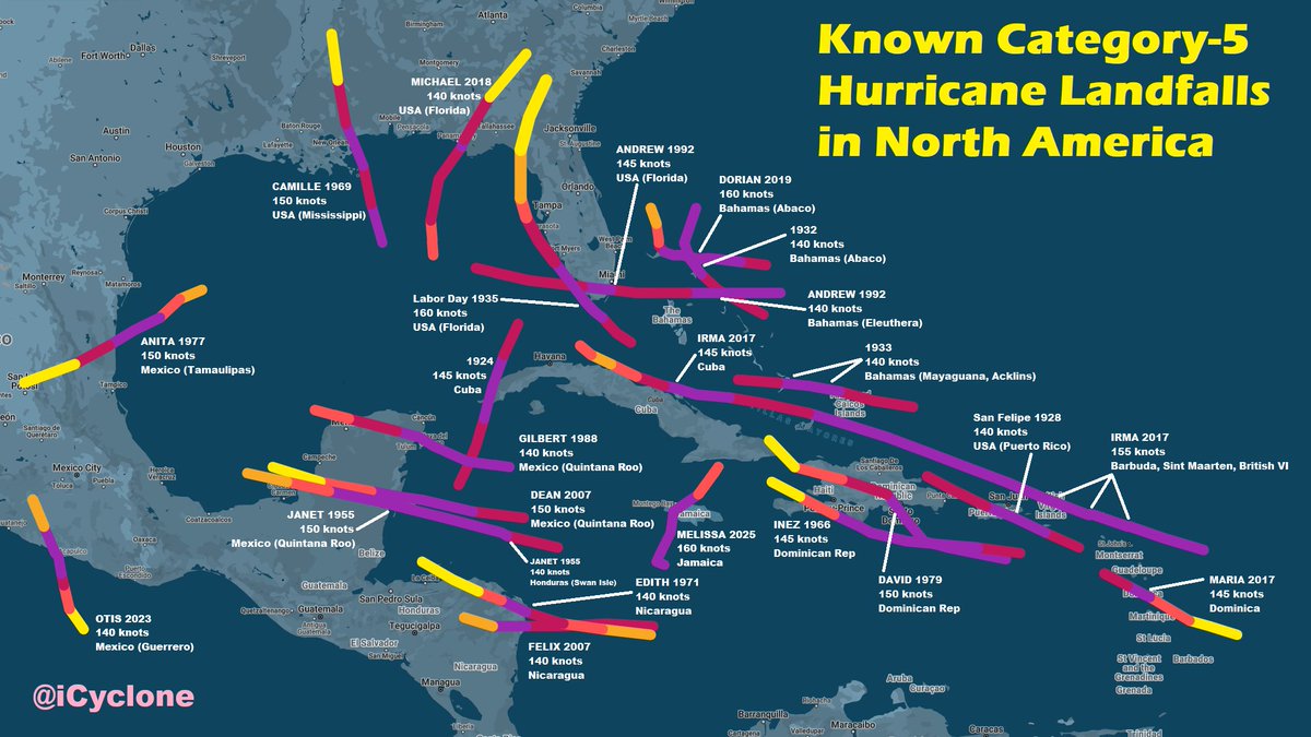
Tracks of all known Category-5 #hurricane landfalls in North America, updated to include #MELISSA in #Jamaica. This only includes storms that were Cat 5 at *landfall* (meaning when center crossed coast). Labor Day 1935, DORIAN 2019, & MELISSA 2025 are in 3-way tie for strongest.

#Sinlaku #Hurricane #Typhoon #disaster #Guam: Category 5 super typhoon Sinlaku with 185 mph winds yesterday hitting the US territories of the Marianas (Saipan, Tinian and Rota) and Guam with ~210,000 Americans total. Tag: Donald Trump, JD Vance, US Navy, FEMA. 📹📸@meteoblue ❤️:


#Sinlaku #Hurricane #Typhoon #disaster #Guam: Category 5 super typhoon Sinlaku with 185 mph winds is aimed directly at US territories of the Marianas (Saipan, Tinian and Rota) and Guam with ~210,000 Americans total. Hopefully Donald Trump, JD Vance, the US Navy are aware of this.

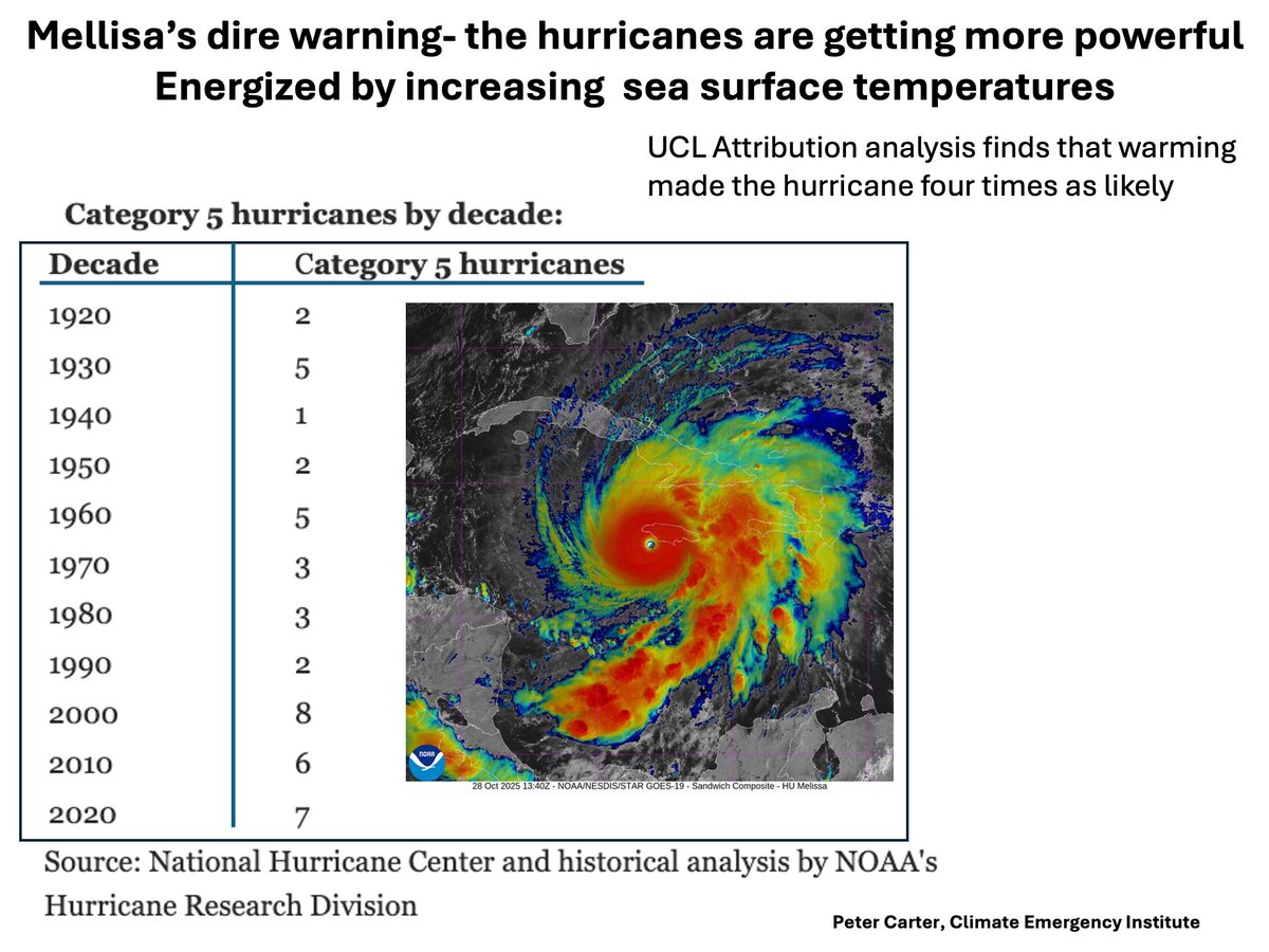
HURRICANE MELISSA MADE 4 TIMES AS LIKELY BY WARMING Category 5 hurricanes are increasing, which will continue under today's accelerating global warming. #melissa #climatechange #hurricane #globalwarming
Something went wrong.
Something went wrong.
United States Trends
- 1. Reed Sheppard N/A
- 2. Reaves N/A
- 3. #TusksUp N/A
- 4. #ForgedInGold N/A
- 5. Brett Howden N/A
- 6. Ayton N/A
- 7. #bucciovertimechallenge N/A
- 8. #Survivor50 N/A
- 9. David Allan Coe N/A
- 10. Double OT N/A
- 11. The Lakers N/A
- 12. Flyers N/A
- 13. Kennard N/A
- 14. Tari Eason N/A
- 15. Cam York N/A
- 16. #beyondthevilla N/A
- 17. Amen Thompson N/A
- 18. Game 6 N/A
- 19. Tony Brothers N/A
- 20. Rockets in 7 N/A