#invest93 search results

Monday 07/14 Tropical Update: We now have Invest 93 off the Florida east coast. Tricky couple days ahead. Eventual turn towards the upper Gulf coast this week. #invest93 #gulf #florida #tropicalupdate #mikesweatherpage

#Florida is spared from the worst possible outcome!! It's now heading to Louisiana & Texas #Invest93

COFFEE TALK: #Invest93 is pulling away, and local impacts are changing. Let's chat! x.com/i/broadcasts/1…

Mississippi might have some tropical issues next week once #Invest93 moves in our direction.

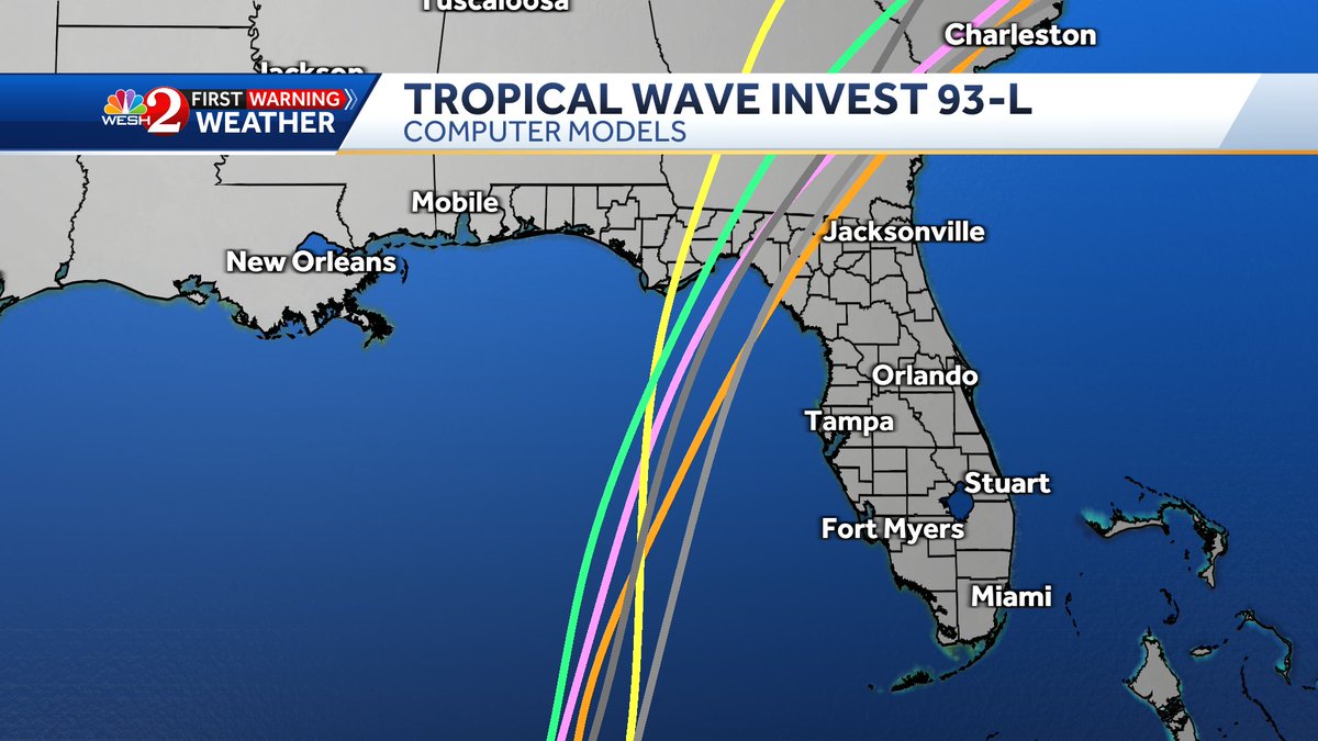
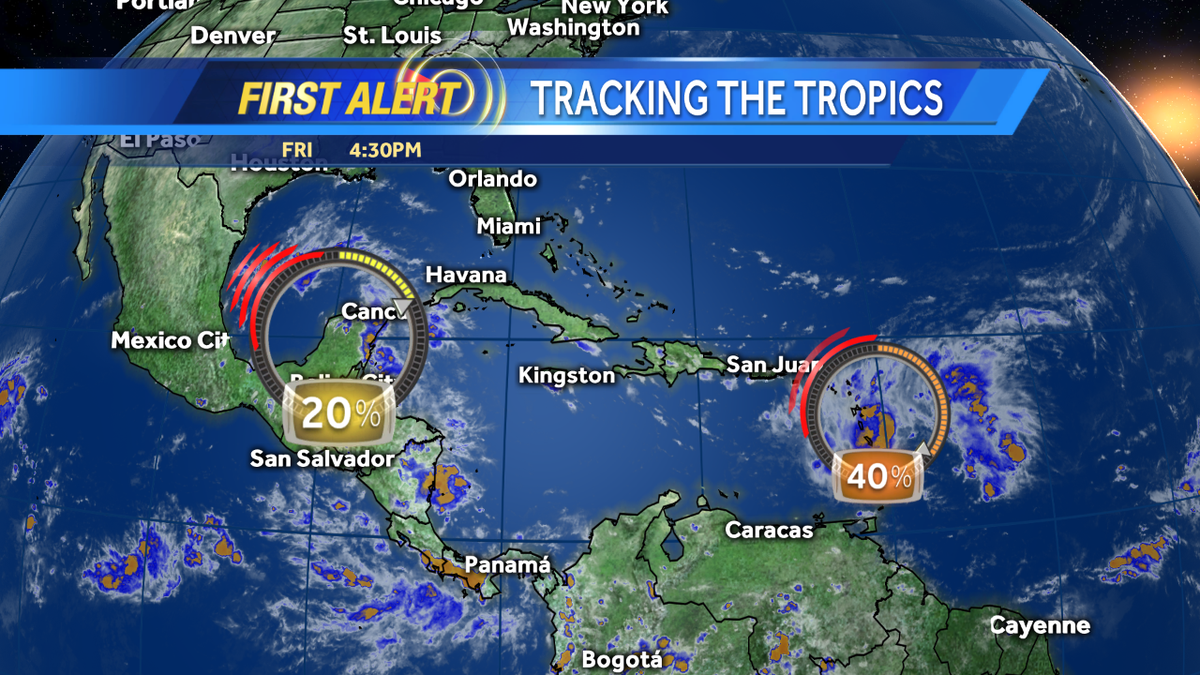
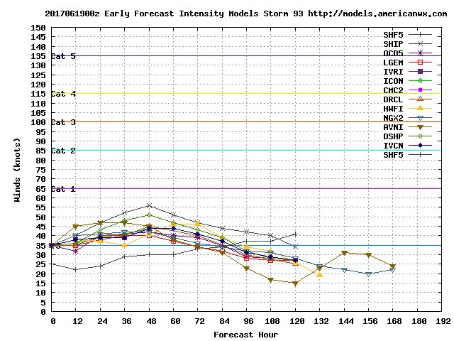
18z spaghetti models showing a more northern track for #93L. This would likely result in no development. It remains to be seen if the center can be tugged or re-form further south.


About to be plenty of Recon flights over #Invest93.... 7 in total on the schedule beginning tomorrow morning.

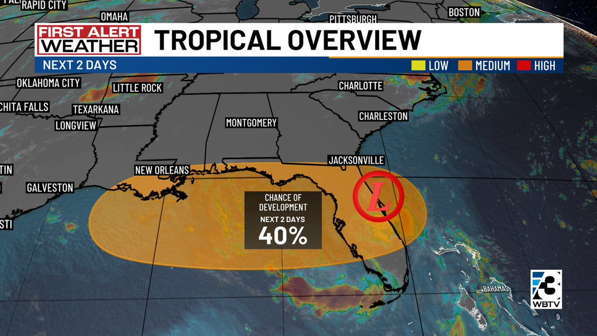
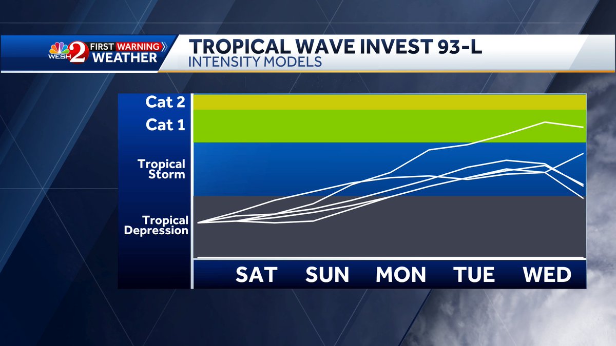
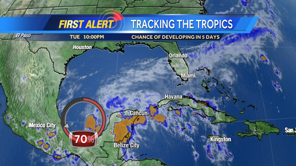
Tropical Storm Bret is not the only system to keep an eye on, #Invest93 has a high, 70% chance of development over the next couple of days. Models bring Bret into the Carribean and curve Invest 93 further to the north. Both worth keeping an eye on

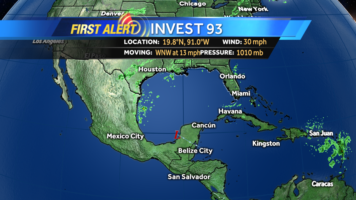
We are currently tracking two areas in the Central and Eastern Atlantic; #Invest92 and #Invest93. #Invest92 will likely become a tropical depression form later today.

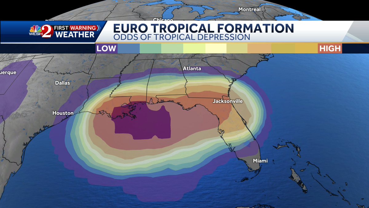
Just wanted to give a quick update on #invest93. This is going to be a big rain maker for #florida then could become a TD or #Dexter as it moves across the #gulf. Flooding is a big concern today for Central Florida. Stay with #weshwx for updates throughout the day

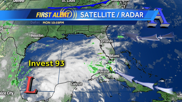
We now have #Invest93! Spaghetti and hurricane models out shortly.

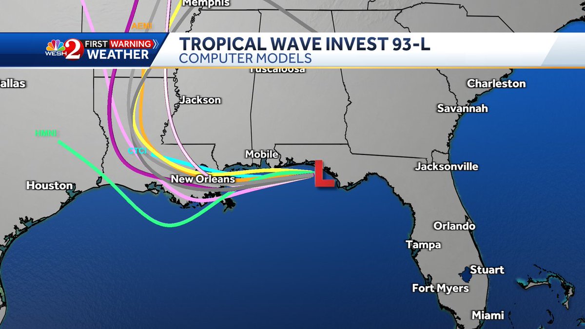
First Alert: The update from the National Hurricane Center holds #Invest93 at 40% development chance over the next 48 hours. Off the FL east coat now, it will drift WEST into the Gulf over thru the midweek period. Most guidance suggest a path toward LA/MS. #NCwx #SCwx #CLTwx
This is a very unusual path for a tropical storm. 😬 #Invest93
Good early morning friends! New model data coming in for #Invest93, and I wanted to get it right out to you. We're keeping close tabs on the overall paths of these model plots, because the more north or south track the storm takes in the Gulf will determine how strong it could


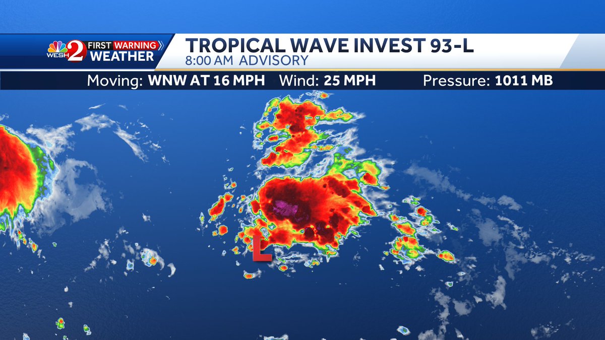
#Invest93-L forms off east coast of #Florida. Main threat for the peninsula is locally heavy rain leading to some flooding
COFFEE TALK: #Invest93 is pulling away, and local impacts are changing. Let's chat! x.com/i/broadcasts/1…
Good morning friends- Early morning model plots for #Invest93 continue hugging the coast. Not a huge concern for big development here thankfully, but it's still something we're watching for development of any kind. Live tracking this and it's local impacts on WESH 2 News

Wednesday 07/16 Tropical Update: Invest 93 still in the upper Gulf. Bringing weather westward the next few days. Flash Flooding possible. Loops back next week? #invest93 #tropicalupdate #mikesweatherpage
#Invest93 has a 80% chance of development over the next few days. Continuing to keep an eye on it and Bret as they both move westward across the Atlantic

The evening computer models are coming in on #Invest93-L. The trend is to NW in the short run then a turn to the north may occur by early next week. Stay with #weshwx for updates.


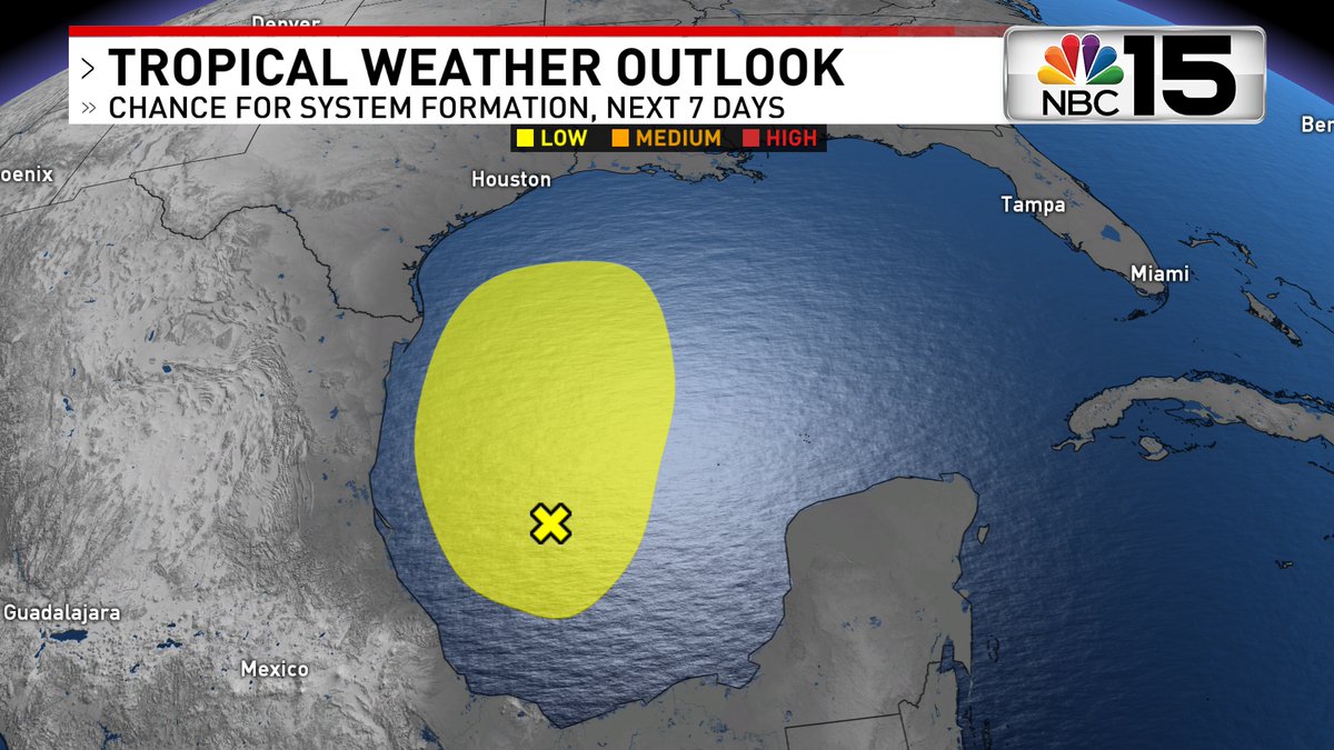
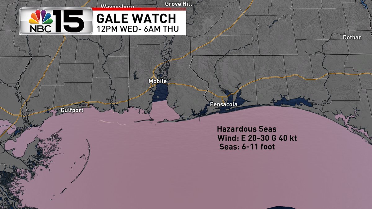
#Invest93 in the Gulf has low formation chance before merging with a front Wed. It'll unleash a few inches of rain in our area starting Wed. Brace for a hazardous gale force wind event: 40 kt gusts & seas 6-11 feet as it tracks across the Gulf. @mynbc15 mynbc15.com/weather


Tracking evening showers and storms, building heat and the latest on #Invest93 headed to #Louisiana #WESHwx facebook.com/TMainolfiWESH/…


TRACKING THE TROPICS: #Invest93 is moving over Florida today, but what happens in the gulf? Let's chat... #Savannah x.com/i/broadcasts/1…

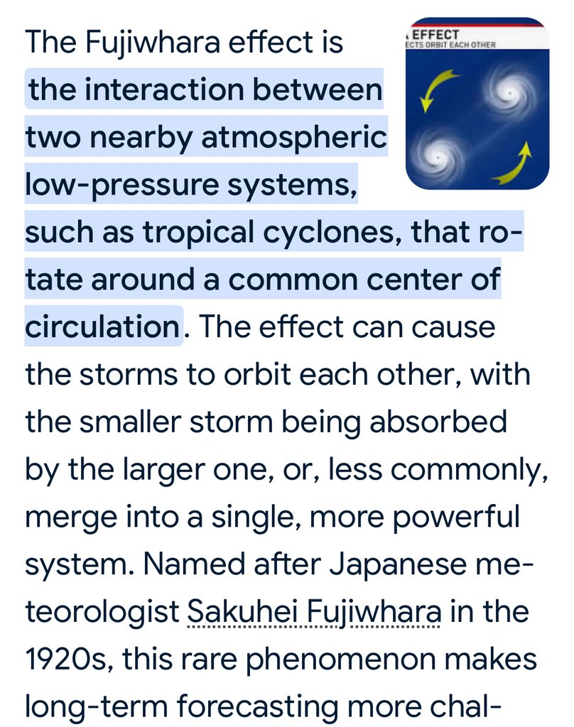
Fujiwhara in the making? 🤔 Heads up on the East coast! Did you know one of our new NASA astronauts (Becky Lawler) flew NOAA #hurricane hunter aircraft? #SERASpace #Invest93 #Invest94

Here's the latest on #Invest93-L folks. This one may develop into our next hurricane but is expected to stay well east of #florida. #Bermuda will need to watch this once closely! Stay with #weshwx for updates.

GFS water vapor channel continues to show how the remnants of #Invest93 and a cold front circle back to #Florida then across the #gulfcost states and on into #Texas, Stay with #weshwx for updates.
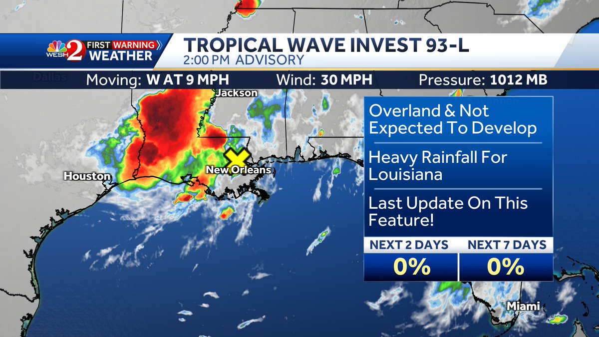
#Invest93 isn't expect to develop as it's over land but as the system lifts north and then east, as a cold front arrives, this could become part of a low that develops near #florida next week and possibly brings more heavy rain. Something to watch folks! #weshwx


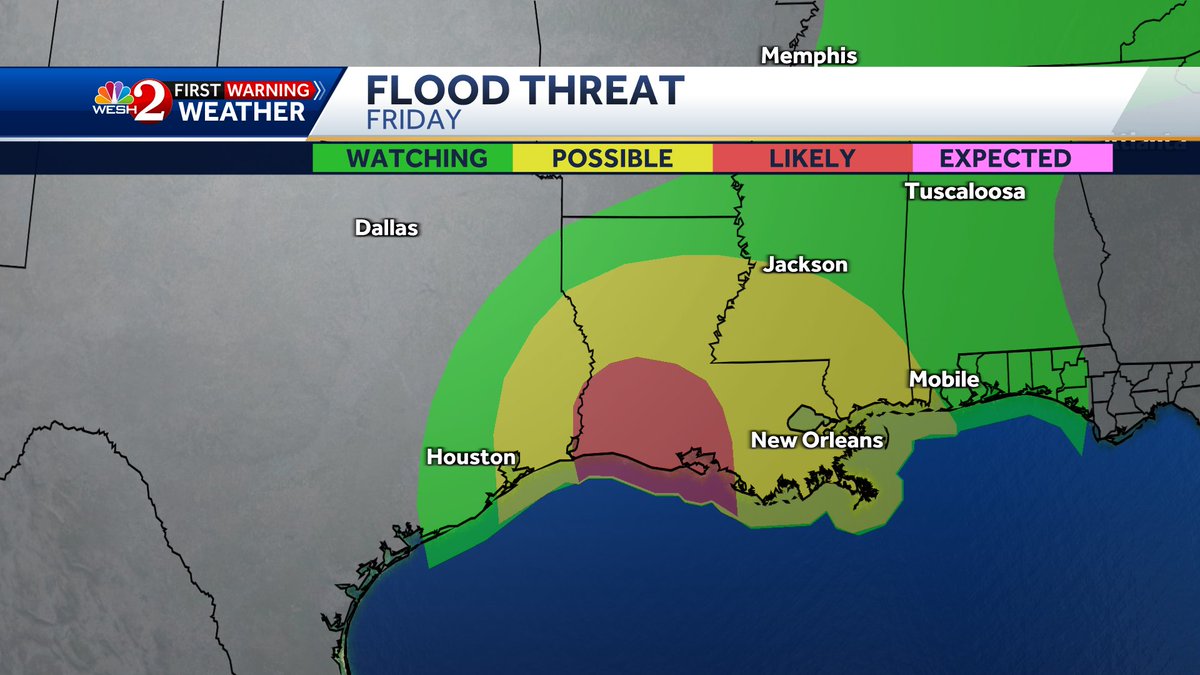
#NHC is monitoring #Invest93 as it approaches #Louisiania. The biggest concerns are heavy rain and flood threats.Stay with #weshwx for updates.
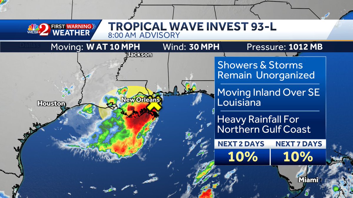
#Invest93 is approaching SE #Louisiana right now. Heavy rain and flooding remain this big concern with this feature both today and Friday. Stay with #weshwx for updates.
COFFEE TALK: #Invest93 is approaching Louisiana, but what's ahead? Let's talk long range! x.com/i/broadcasts/1…

Heavy band of storms moving SW from northshore across the Lake through metro New Orleans from #Invest93. #lawx #wxtwitter #nolatwitter
Flood threat is looking likely for a good part of #Louisiana Thursday into Friday as #invest93 moves in. Stay with #WESHwx for updates.

Tracking evening showers and storms, building heat and the latest on #Invest93 headed to #Louisiana #WESHwx facebook.com/TMainolfiWESH/…
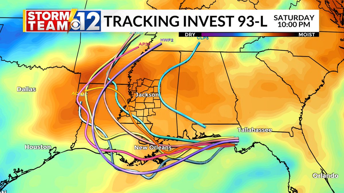
Visible satellite of #Invest93 shows a poorly defined system right now. It is over some very warm water and the shear is low so we will monitor it until it makes landfall in Louisiana on Thursday! #weshwx
Good afternoon- New data shows the center, sloppy as it may be, of #Invest93 moving off the coast, and starting over HOT water. Models give a small window where it could form into a depression or weak storm. Remember, development or not, rain and flooding will be the main
Wednesday 07/16 Tropical Update: Invest 93 still in the upper Gulf. Bringing weather westward the next few days. Flash Flooding possible. Loops back next week? #invest93 #tropicalupdate #mikesweatherpage

🌧️ A flood watch is in effect from Wednesday afternoon through late Friday night as Invest 93 pushes rounds of rain into our area. Stay weather-aware and plan ahead! #NOLAWeather #FloodWatch #Invest93 See the latest: shorturl.at/f89G4


The 7 AM model update has a general consensus across spaghetti plots that #Invest93 could track west along the Gulf Coast then push NW just west the MS river. 🌊 Localized heavy rain and flash flooding are the main threats THU-SAT. wjtv.com/weather #mswx #tropicsupdate
Good morning friends- Early morning model plots for #Invest93 continue hugging the coast. Not a huge concern for big development here thankfully, but it's still something we're watching for development of any kind. Live tracking this and it's local impacts on WESH 2 News
#Florida is spared from the worst possible outcome!! It's now heading to Louisiana & Texas #Invest93
COFFEE TALK: #Invest93 is pulling away, and local impacts are changing. Let's chat! x.com/i/broadcasts/1…


Area of low pressure near Leeward Islands is now #Invest93. Models show it moving near the Bahamas. #tropics @WWLTV

About to be plenty of Recon flights over #Invest93.... 7 in total on the schedule beginning tomorrow morning.
Here's the very latest on #Invest93 which is likely to bring tropical trouble our way Late Tuesday into Wednesday. Stay with @WESH as we continue to iron ou the impacts. #weshwx
#NHC is monitoring #Invest93 as it approaches #Louisiania. The biggest concerns are heavy rain and flood threats.Stay with #weshwx for updates.
Just wanted to give a quick update on #invest93. This is going to be a big rain maker for #florida then could become a TD or #Dexter as it moves across the #gulf. Flooding is a big concern today for Central Florida. Stay with #weshwx for updates throughout the day

Hurricane Hunters @403PA set to fly at 1pm in to #Invest93-L. Their data will tell us if it's TD or TS #WTSP #flwx

At 10 on @WESH #Invest93 looking better organized tonight and could be upgraded tonight. Latest tracks coming up.


Here's the latest on #Invest93. A cold front should keep this one on the weak side but worth watching. #wesh2tropics

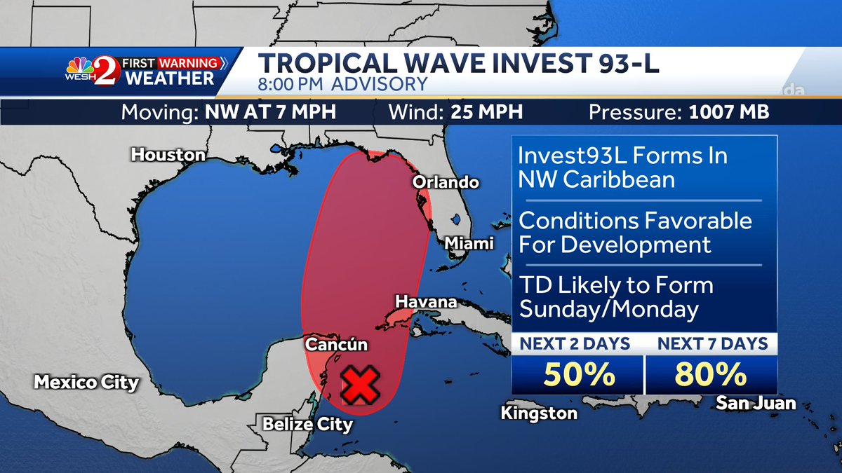
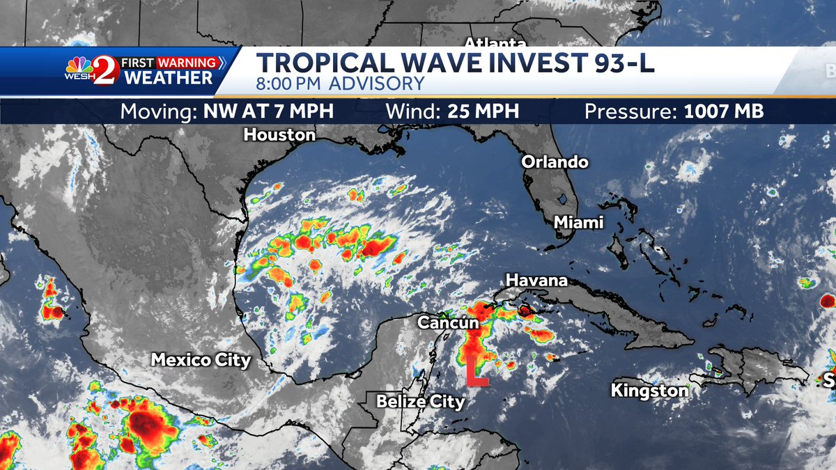
#Invest93 could form into a tropical depression today or Sat. in the NW Caribbean & then move NE. @WWLTV

AT 11 on @WESH after the #Blacklist I'll have the latest on #Invest93, the warm Tuesday temps + when rain may return.
#Invest93 remains weak and disorganized as it moves NW toward the Bahamas with little to no development. @WWLTV

Here's the latest on #Invest93. A cold front should keep this one on the weak side but worth watching. #wesh2tropics
AT 5 on @WESH - The heat continues #Saturday and it's heating up in the Tropics. Next the latest on #Invest93. #wesh

RT @EricBurrisWESH: Just before 6, and I wanted to post about what more than likely will become the next named system in the tropics. This is now #Invest93, and one the entire gulf coast of the US needs to watch closely...
Tracking evening showers and storms, building heat and the latest on #Invest93 headed to #Louisiana #WESHwx facebook.com/TMainolfiWESH/…

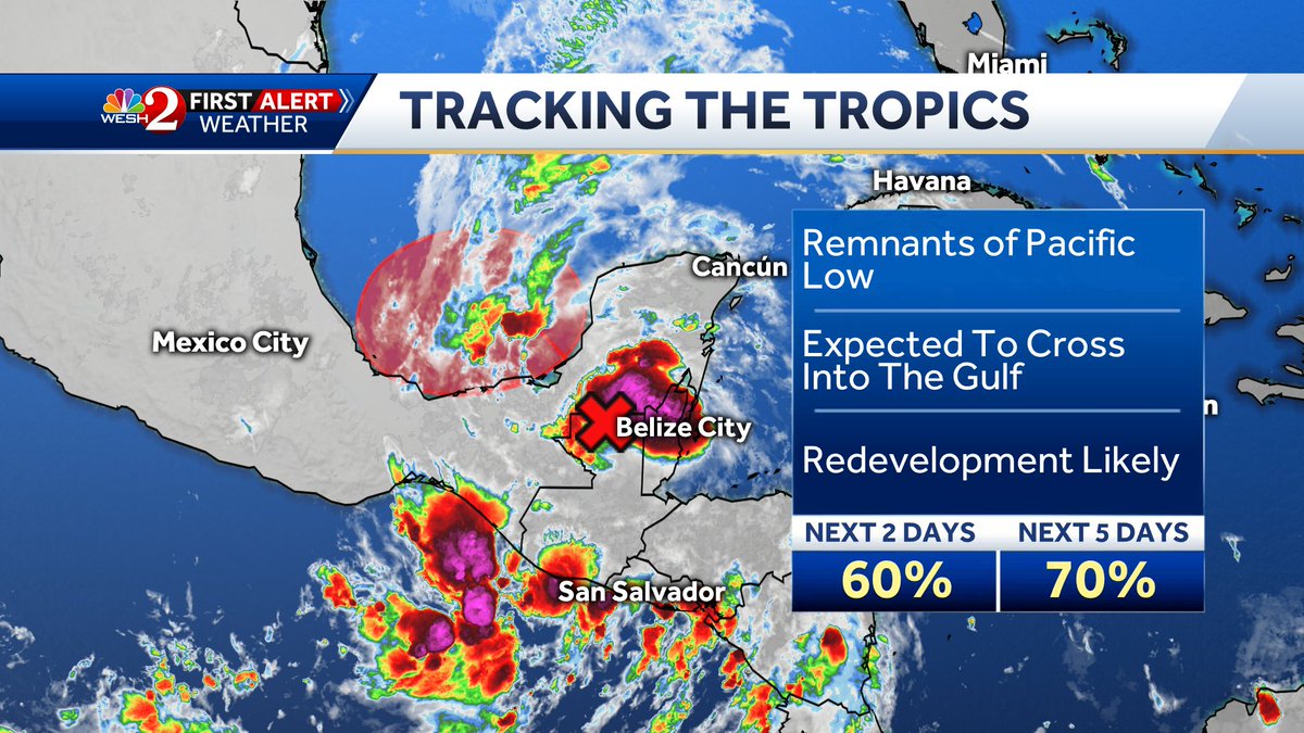
The latest on #Invest93 shows it near Belize. Forecast models show it in S Gulf then turning toward FL. @WWLTV


Something went wrong.
Something went wrong.
United States Trends
- 1. #NFLDraft N/A
- 2. Carnell Tate N/A
- 3. Reese N/A
- 4. Reese N/A
- 5. Fernando Mendoza N/A
- 6. David Bailey N/A
- 7. Jeremiyah Love N/A
- 8. Chiefs N/A
- 9. Delane N/A
- 10. Caleb Downs N/A
- 11. Cam Ward N/A
- 12. Cardinals N/A
- 13. Giants N/A
- 14. Jordyn Tyson N/A
- 15. Browns N/A
- 16. Bain N/A
- 17. Jets N/A
- 18. Raiders N/A
- 19. Saints N/A
- 20. #RaiderNation N/A