#mnwx search results

Copy & Paste: Tomorrow brings a day much like today, but the winds won’t be nearly as breezy #WeatherLoon #mnwx
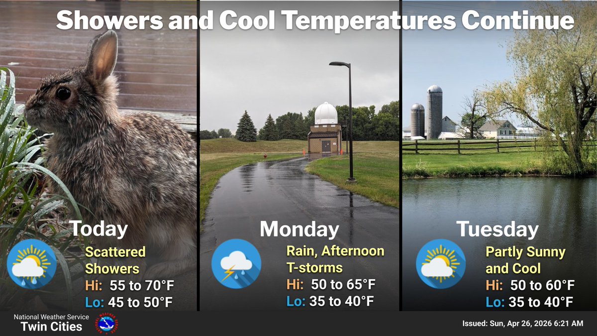
A crisp spring chill took over the state today, with a northwest breeze doing the heavy lifting. Cooler‑than‑normal temps hold for now, but the weekend could nudge us back to above average temps #WeatherLoon #mnwx


Spring can be reluctant at 45N latitude. Look for cool sunny days and frosty mornings the next several days. Hang in there gardeners! 🌿 #mnwx mprnews.org/story/2026/04/…
mprnews.org
Reluctant spring of 2026: Sunny and cool with frosty mornings for much of Minnesota
A fresh but cool spring air mass lingers across Minnesota this week.

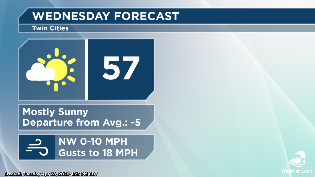
Dry into the weekend, except for a few sprinkles Wednesday afternoon. Highs in the 50s with lows in the 30s through Saturday morning, then warmer over the weekend. Conditions are favorable for frost each overnight period which could harm newly developing plants. #mnwx #wiwx

Protect the plants! Tonight will see much of the state fall into frost/freeze territory, and we'll have more of that each night into Saturday morning. #WeatherLoon #mnwx youtube.com/@WeatherLoon/l…


0.98" rain here at our Fairmont studios from Sunday and Monday. #mnwx

Flowers are in bloom with the recent heavy rains across southern Minnesota; however, flooding is a major concern in the Arrowhead. The latest: weatherloon.com/blog/minnesota… #mnwx
weatherloon.com
Spring Has Sprung - Watching Flood Issues After Rece... | Weather Loon
While flowers are in bloom with recent heavy rains, flooding is a concern up in the Arrowhead.

🌬️ Tracking slowly waning winds through the rest of your Tuesday. An increase in clouds is expected ahead of a stray shower tonight. Cooler and drier conditions remain in place through the end of the week #mnwx #iawx

Good Morning UND! We have some chilly temperatures for today with mostly clear conditions. This will continue throughout the week with a steady warm up, ending with a pleasantly warm weekend! #ndwx #UNDaerospace #mnwx

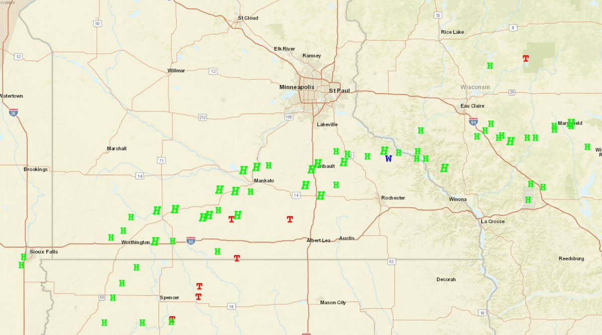
At 2:00 AM CDT, 2 N Clear Lake [Lake Co, MN] Emergency Mngr reports Flood. Delayed report. Cramer road between Harriet Lake Rd and Two Moose Trail is closed due to a washout overnight. Report time estimated. #mnwx mesonet.agron.iastate.edu/lsr/?by=wfo&wf…
![iembot_dlh's tweet image. At 2:00 AM CDT, 2 N Clear Lake [Lake Co, MN] Emergency Mngr reports Flood. Delayed report. Cramer road between Harriet Lake Rd and Two Moose Trail is closed due to a washout overnight. Report time estimated. #mnwx mesonet.agron.iastate.edu/lsr/?by=wfo&wf…](https://pbs.twimg.com/media/HHABqaXWwAAFzzx.jpg)
At 8:58 AM CDT, 1 N Knife River [Lake Co, MN] Mesonet reports Rain of 1.02 Inch. Mesonet station KNFRV 1 N Knife River. #mnwx mesonet.agron.iastate.edu/lsr/?by=wfo&wf…
![iembot_dlh's tweet image. At 8:58 AM CDT, 1 N Knife River [Lake Co, MN] Mesonet reports Rain of 1.02 Inch. Mesonet station KNFRV 1 N Knife River. #mnwx mesonet.agron.iastate.edu/lsr/?by=wfo&wf…](https://pbs.twimg.com/media/HG_7rofWoAAr8QZ.jpg)
At 8:56 AM CDT, 10 N Nashwauk [Itasca Co, MN] Mesonet reports Rain of 1.12 Inch. Mesonet station GW3623 NASHWAUK. #mnwx mesonet.agron.iastate.edu/lsr/?by=wfo&wf…
![iembot_dlh's tweet image. At 8:56 AM CDT, 10 N Nashwauk [Itasca Co, MN] Mesonet reports Rain of 1.12 Inch. Mesonet station GW3623 NASHWAUK. #mnwx mesonet.agron.iastate.edu/lsr/?by=wfo&wf…](https://pbs.twimg.com/media/HG_7raEXcAEEcNt.jpg)
At 8:59 AM CDT, 3 ESE Zim [St. Louis Co, MN] Mesonet reports Rain of 1.16 Inch. Mesonet station GW2884 Eveleth. #mnwx mesonet.agron.iastate.edu/lsr/?by=wfo&wf…
![iembot_dlh's tweet image. At 8:59 AM CDT, 3 ESE Zim [St. Louis Co, MN] Mesonet reports Rain of 1.16 Inch. Mesonet station GW2884 Eveleth. #mnwx mesonet.agron.iastate.edu/lsr/?by=wfo&wf…](https://pbs.twimg.com/media/HG_7q5-W8AAk0RP.jpg)
At 9:00 AM CDT, 1 NNE Proctor [St. Louis Co, MN] Cocorahs reports Rain of 1.20 Inch. Cocorahs station MN-SL-314 Proctor 0.6 NNE. #mnwx mesonet.agron.iastate.edu/lsr/?by=wfo&wf…
![iembot_dlh's tweet image. At 9:00 AM CDT, 1 NNE Proctor [St. Louis Co, MN] Cocorahs reports Rain of 1.20 Inch. Cocorahs station MN-SL-314 Proctor 0.6 NNE. #mnwx mesonet.agron.iastate.edu/lsr/?by=wfo&wf…](https://pbs.twimg.com/media/HG_7qrRWoAApUjm.jpg)
At 9:00 AM CDT, 1 E Hibbing [St. Louis Co, MN] Mesonet reports Rain of 1.22 Inch. Mesonet station HBBNG 1 NE Hibbing. #mnwx mesonet.agron.iastate.edu/lsr/?by=wfo&wf…
![iembot_dlh's tweet image. At 9:00 AM CDT, 1 E Hibbing [St. Louis Co, MN] Mesonet reports Rain of 1.22 Inch. Mesonet station HBBNG 1 NE Hibbing. #mnwx mesonet.agron.iastate.edu/lsr/?by=wfo&wf…](https://pbs.twimg.com/media/HG_7qb8WwAAscR4.jpg)
At 8:53 AM CDT, 6 ESE Hibbing [St. Louis Co, MN] ASOS reports Rain of 1.26 Inch. ASOS station KHIB Chisholm-Hibbing Airport. #mnwx mesonet.agron.iastate.edu/lsr/?by=wfo&wf…
![iembot_dlh's tweet image. At 8:53 AM CDT, 6 ESE Hibbing [St. Louis Co, MN] ASOS reports Rain of 1.26 Inch. ASOS station KHIB Chisholm-Hibbing Airport. #mnwx mesonet.agron.iastate.edu/lsr/?by=wfo&wf…](https://pbs.twimg.com/media/HG_7qOaWQAAci7l.jpg)
At 9:00 AM CDT, 5 SSE Duxbury [Pine Co, MN] Mesonet reports Rain of 1.38 Inch. Mesonet station SNDS1 5 SE Duxbury. #mnwx mesonet.agron.iastate.edu/lsr/?by=wfo&wf…
![iembot_dlh's tweet image. At 9:00 AM CDT, 5 SSE Duxbury [Pine Co, MN] Mesonet reports Rain of 1.38 Inch. Mesonet station SNDS1 5 SE Duxbury. #mnwx mesonet.agron.iastate.edu/lsr/?by=wfo&wf…](https://pbs.twimg.com/media/HG_7p-hXoAAlPfz.jpg)
At 8:55 AM CDT, 1 NNW Brainerd [Crow Wing Co, MN] Mesonet reports Rain of 1.45 Inch. Mesonet station GW4072 BRAINERD. #mnwx mesonet.agron.iastate.edu/lsr/?by=wfo&wf…
![iembot_dlh's tweet image. At 8:55 AM CDT, 1 NNW Brainerd [Crow Wing Co, MN] Mesonet reports Rain of 1.45 Inch. Mesonet station GW4072 BRAINERD. #mnwx mesonet.agron.iastate.edu/lsr/?by=wfo&wf…](https://pbs.twimg.com/media/HG_7pc6XgAArmi7.jpg)
At 9:00 AM CDT, 5 NNE Garrison [Aitkin Co, MN] Cocorahs reports Rain of 1.60 Inch. Cocorahs station MN-AT-34 Aitkin 11.8 SSW. #mnwx mesonet.agron.iastate.edu/lsr/?by=wfo&wf…
![iembot_dlh's tweet image. At 9:00 AM CDT, 5 NNE Garrison [Aitkin Co, MN] Cocorahs reports Rain of 1.60 Inch. Cocorahs station MN-AT-34 Aitkin 11.8 SSW. #mnwx mesonet.agron.iastate.edu/lsr/?by=wfo&wf…](https://pbs.twimg.com/media/HG_7pOeWoAAJTiw.jpg)


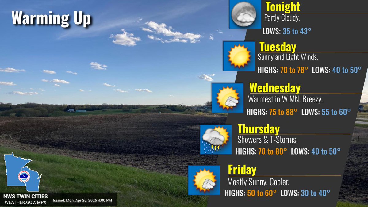
Cooler temperatures are expected for much of this week with highs in the 50s for most. Overnight lows later into the week may reach the freezing mark in some locations. Dry conditions are expected with minimal precipitation chances through Friday. #mnwx #wiwx #iawx

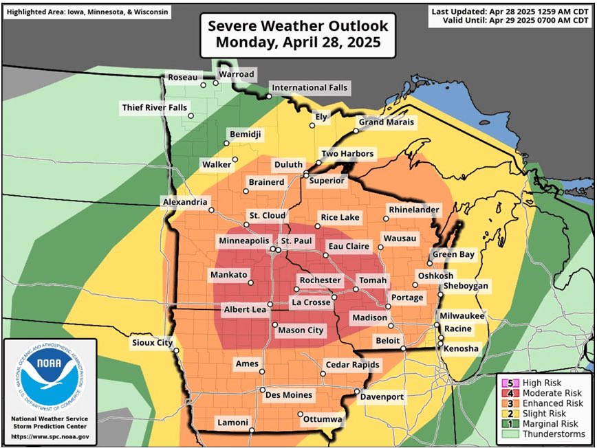
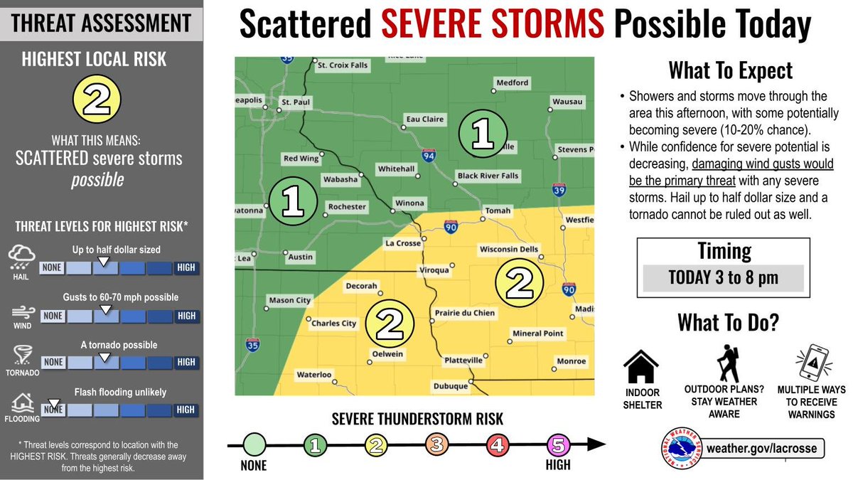
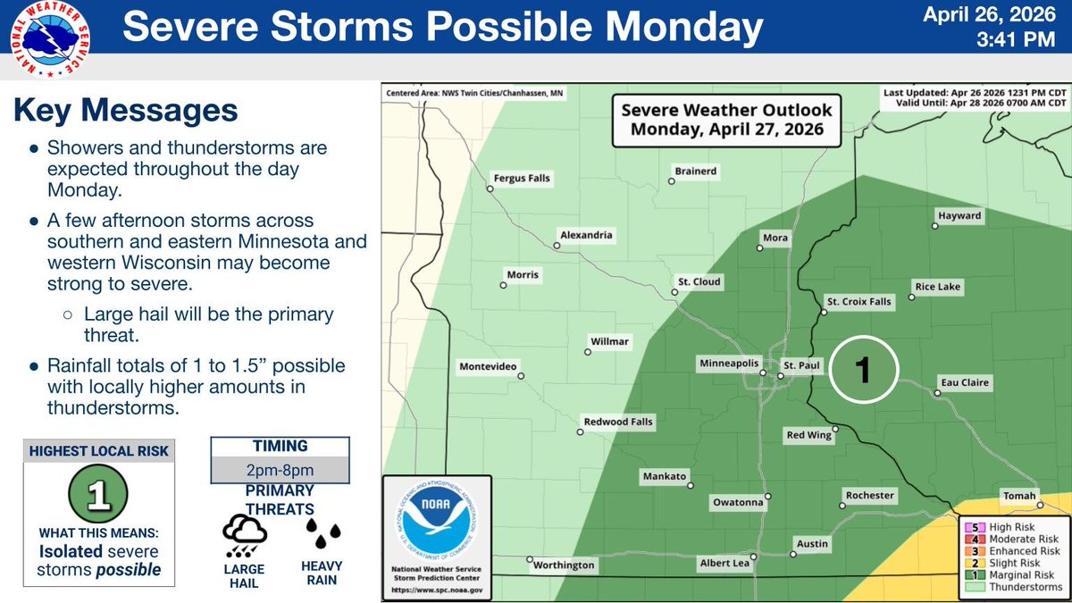
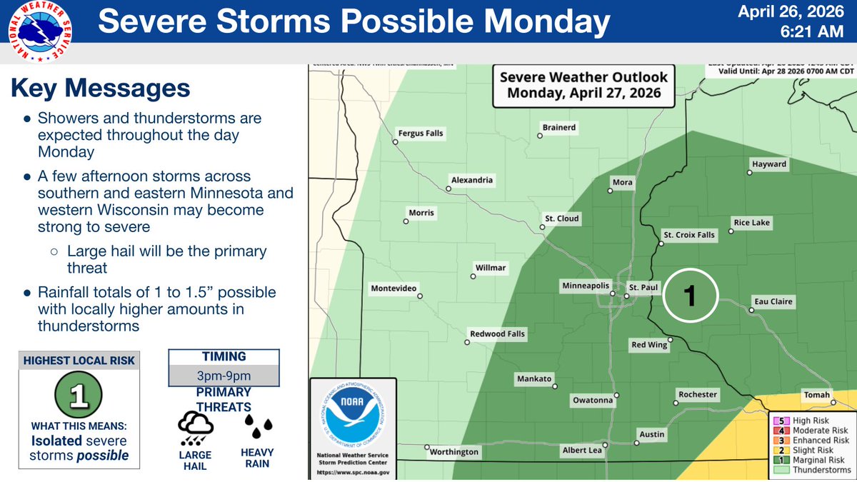
4/27 @6am The risk for severe weather returns this afternoon. With the local area residing on the north side of the risk area, there remains uncertainty on the coverage and severity of the storms, driven by how our morning storms unfold. Stay weather aware. #mnwx #wiwx #iawx

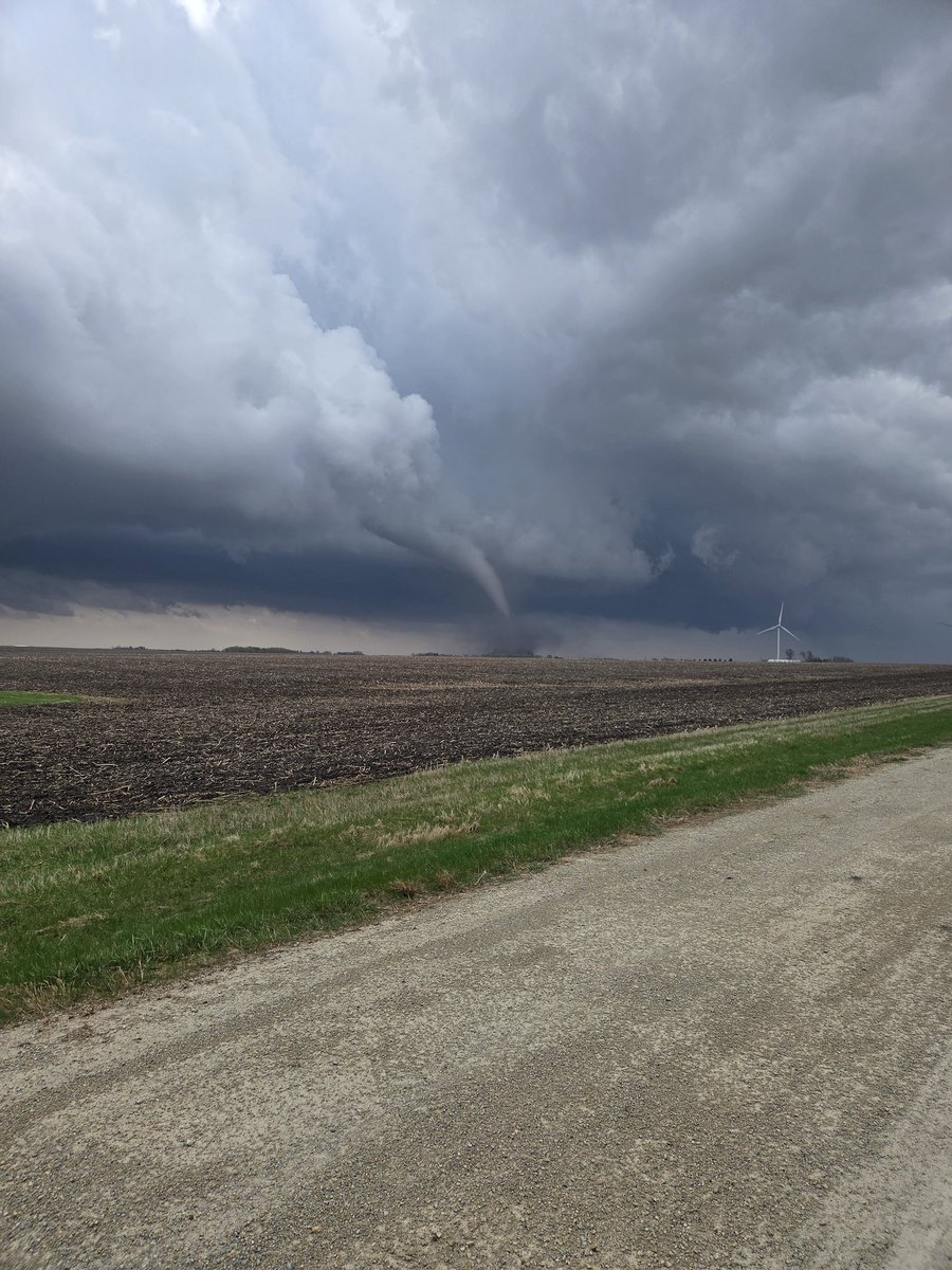
Screen grab of @ReedTimmerUSA INSIDE the #tornado earlier in Minnesota! Dominator 3 in ACTION! #mnwx

4/26 @1pm The threat for severe weather returns for Mon PM. Confidence in storm severity for the local area is on the lower side, but the potential exists for a few hours of severe weather. Stay weather aware tomorrow! #wiwx #iawx #mnwx
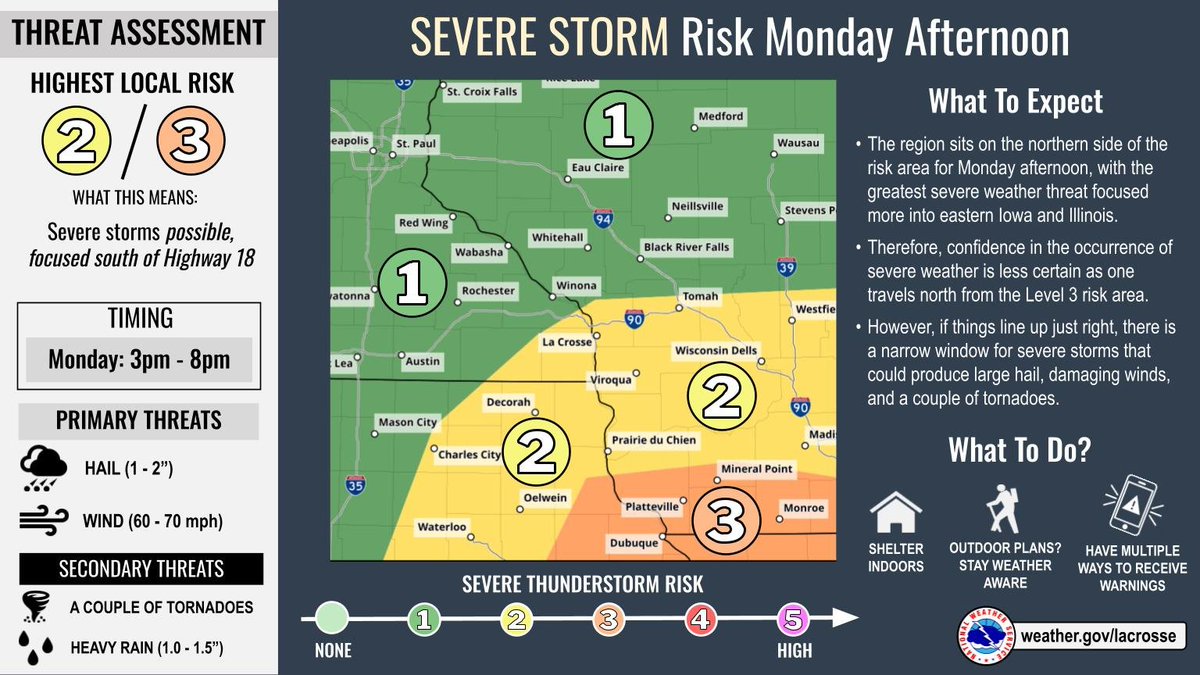
Scattered showers will increase this evening, becoming widespread steady rain tonight. Rain will continue into tomorrow morning with a chance for strong to severe storms during the afternoon. Rainfall totals of 1 to 1.5” possible with locally higher amounts in storms. #mnwx #wiwx

It will be a wet Monday, but after today, the rest of the week will be pretty quiet, with the main issues being the potential for some frost most mornings. #mnwx #wiwx

Storms are developing along and west of the Mississippi River. These will continue to move off to the northeast. A few of these storms may become severe. Main threats would be hail up to 1", winds up to 60 mph, and a brief tornado cannot be rule out. #iawx #mnwx #wiwx


TOMORROW (4/13): Large hail (2-3"), damaging winds, & a few tornadoes are possible across parts of MN into WI, where an Enhanced Risk of severe storms is in effect. Storms may develop in the later day and move east to the Great Lakes overnight. #MNwx #WIwx

Wow. Big swath of 2"-4" rainfall west of MSP Monday. Locally 3"-4"+ around Royalton. MSP around 1" south but 1 .5"+ west/north. Get ready for a leafy 🌿 green explosion this week! #mnwx

Dry into the weekend, except for a few sprinkles Wednesday afternoon. Highs in the 50s with lows in the 30s through Saturday morning, then warmer over the weekend. Conditions are favorable for frost each overnight period which could harm newly developing plants. #mnwx #wiwx
A stretch of dry weather is on tap following yesterday's rainfall. High temperatures will be running about 10 degrees below normal through Friday. Morning lows toward the end of the week will fall to near freezing, posing a frost/freeze risk. #mnwx #wiwx


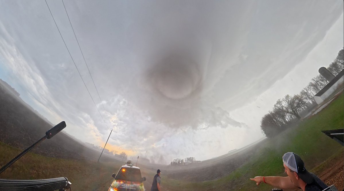
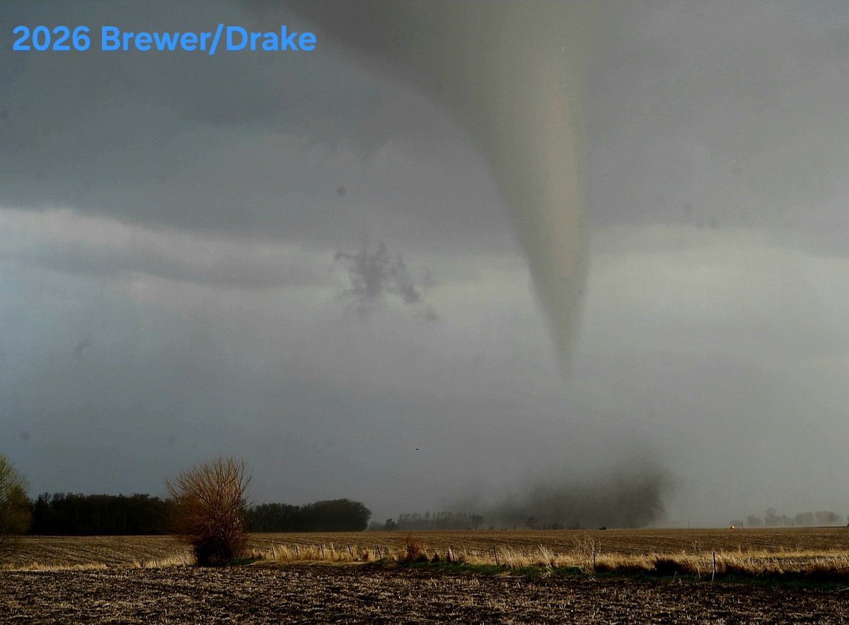
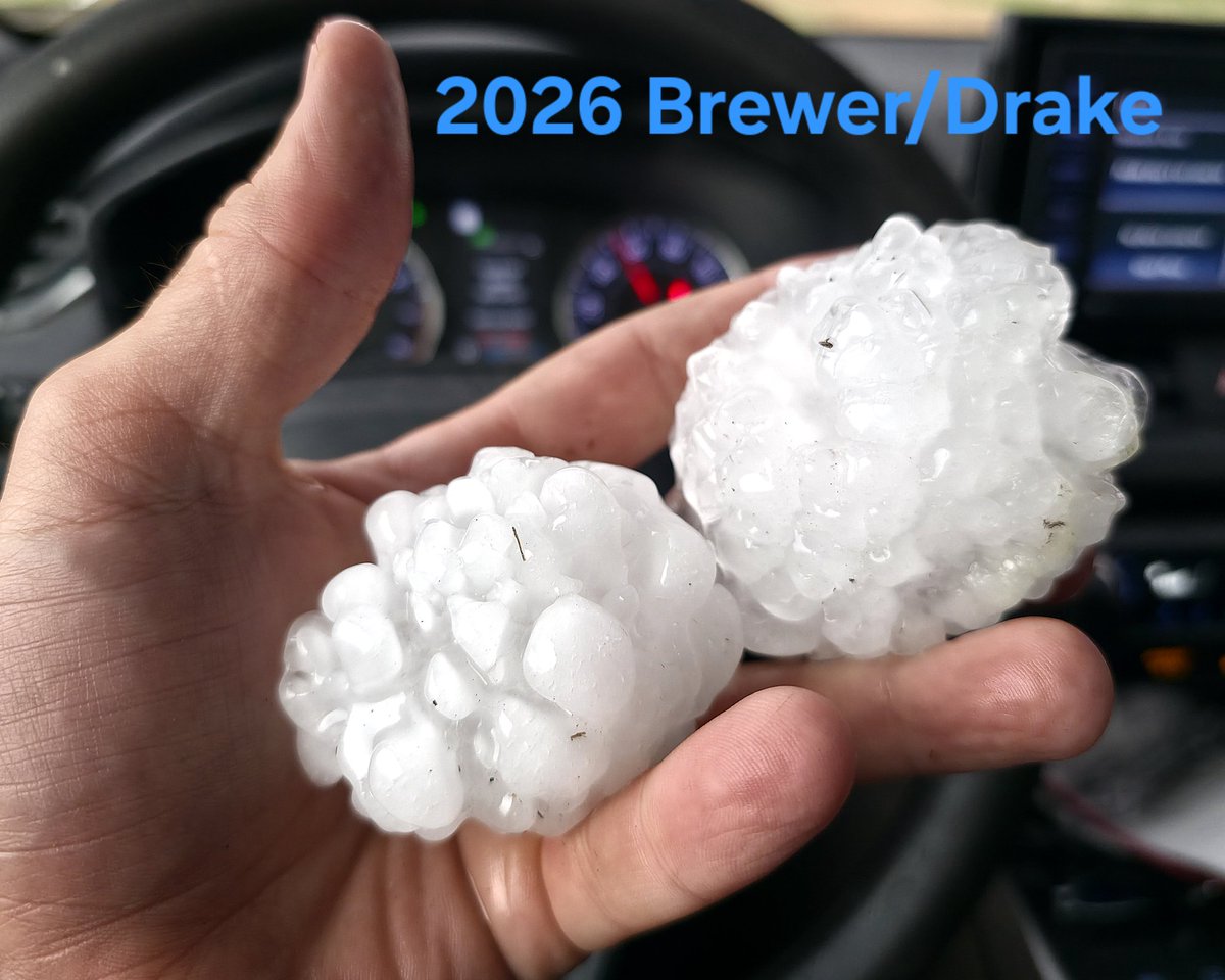
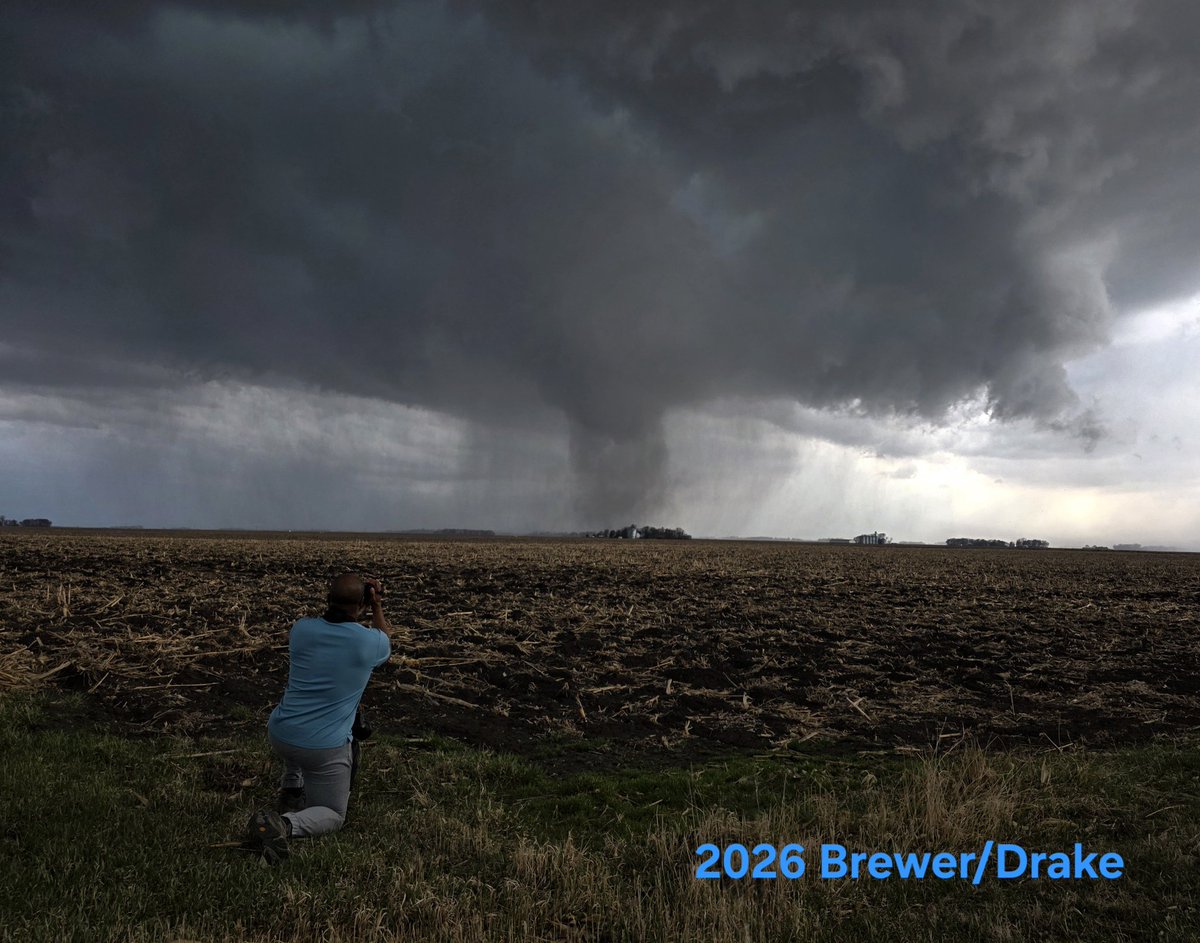
Today, April 13, 2026, @JustonStrmRider, Jeff Turney, and I documented a relatively long-lived tornado and prolific hail-producing supercell near the community of Truman, Minnesota. Big stone hit and cut Jeff's scalp! #MNwx

A few severe storms remain possible this afternoon and early evening, although the confidence in severe weather is on the low side due to the morning showers and storms. #iawx #mnwx #wiwx


The Midwest saw over 100 tornado warnings issued during Friday's outbreak! 25 tornadoes touched down, including an EF-3 in Wisconsin! #MNwx READ MORE: weathernationtv.com/news/severe-st…

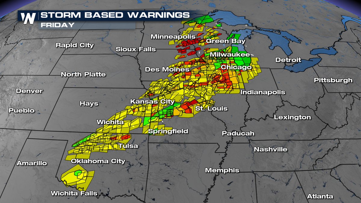

We no longer have any severe or tornado warnings for our area and we expect to remain warning free for the rest of the night. THANK YOU to everyone for all of your reports tonight. We had 3 confirmed tornadoes occur in southern MN and widespread hail (up to 3 inches) #mnwx #wiwx
Lake Minnetonka ice out declared late this afternoon! About 2 weeks earlier than the long term average. #mnwx

Something went wrong.
Something went wrong.
United States Trends
- 1. #WWENXT N/A
- 2. Comey N/A
- 3. #bucciovertimechallenge N/A
- 4. Derrick White N/A
- 5. King Charles N/A
- 6. Embiid N/A
- 7. #DaredevilBornAgain N/A
- 8. Lizzy Rain N/A
- 9. Quentin Grimes N/A
- 10. Jaylen Brown N/A
- 11. Drew Romo N/A
- 12. LIFE GOES ON N/A
- 13. The Celtics N/A
- 14. Tony Bradley N/A
- 15. Baepsae N/A
- 16. #Sixers N/A
- 17. Will Kroos N/A
- 18. Tyler Myers N/A
- 19. #LetsGoBuffalo N/A
- 20. Stokes N/A