#ndwx search results

Strong west winds of 25-30 mph with higher gusts along with relative humidity as low as 20 percent will lead to Red Flag conditions across NE and east central North Dakota today. Near critical conditions will be present for surrounding areas. #NDwx #MNwx
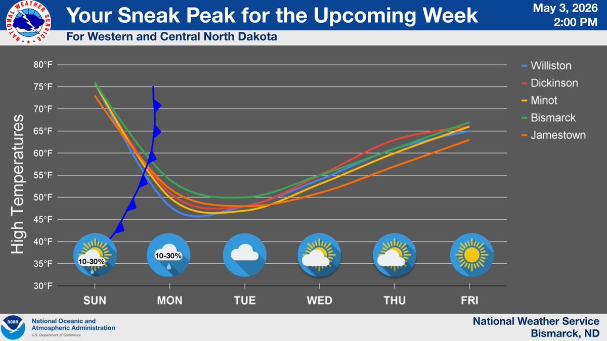
With a cold front passing through the region overnight, cooler weather is on tap to start the coming workweek. Luckily, a gradual warmup is then anticipated to bring us broadly back into the 60s by Friday. #NDwx
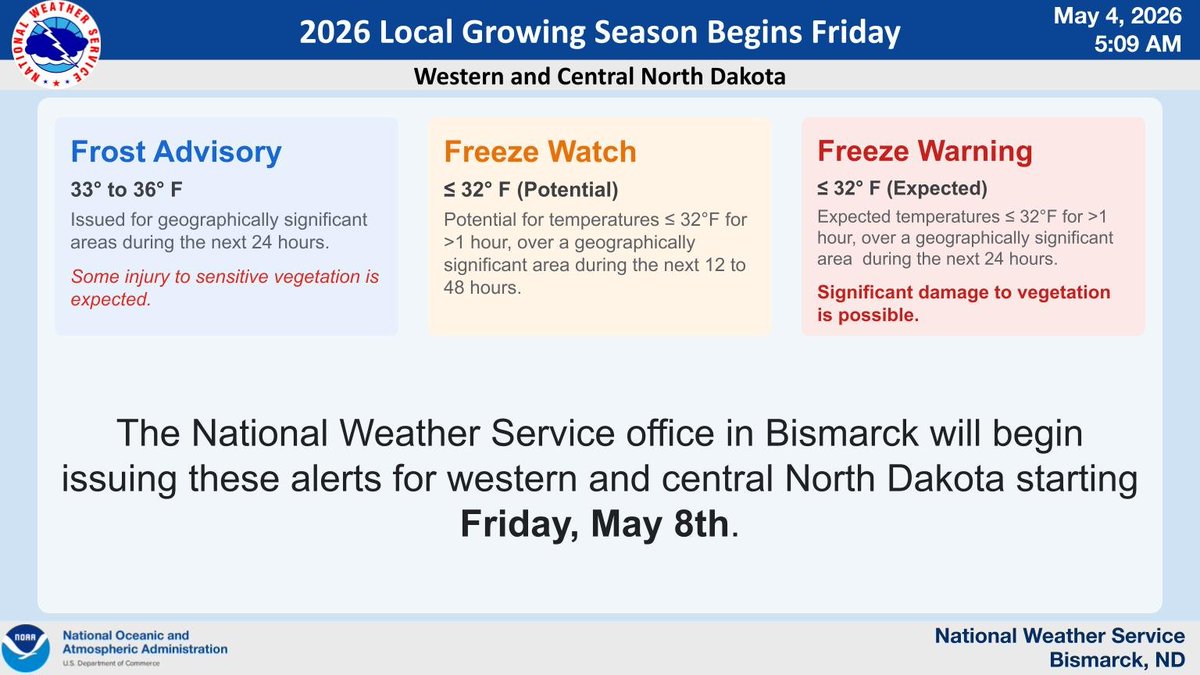
The National Weather Service Office in Bismarck will begin issuing Frost Advisories, Freeze Watches and Freeze Warnings on Friday May 8th. #NDwx #NDag
Windy today with critical fire weather concerns. After an early week cooldown, we warm back up. #NDwx


After a weekend in the 70s, today's blustery wind was insult to injury with those falling temperatures. The wind does gradually let up overnight, but tomorrow will still be cool and a bit breezy, with highs stuck in the 40s and a few sprinkles/flurries possible too. #ndwx #mnwx
After a warm and windy Sunday, a cold front comes through tonight. A few light rain showers will come along with the front, but the main impacts will be a return to cooler temperatures. Highs will again be in the 40s and 50s with lows near or below freezing #NDwx #MNwx

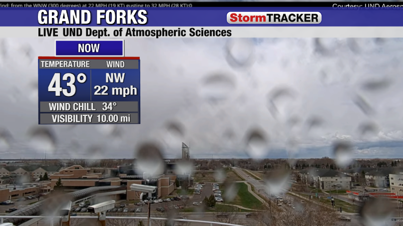
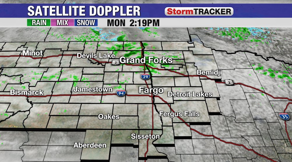
The second batch of showers for today has developed across the northern valley. We've seen sprinkles in both Grand Forks and Devils Lake this afternoon. Don't expect much rain out of these, but it'll add on to the cool and damp conditions we have for the afternoon. #ndwx #mnwx

Critical fire weather conditions are active today across North Dakota, Montana, and Wyoming. Red Flag Warnings are in effect with westerly wind gusts up to 45 MPH and humidity dropping to 15%. Any fires that ignite will spread rapidly. #NDwx #MTwx #WYwx

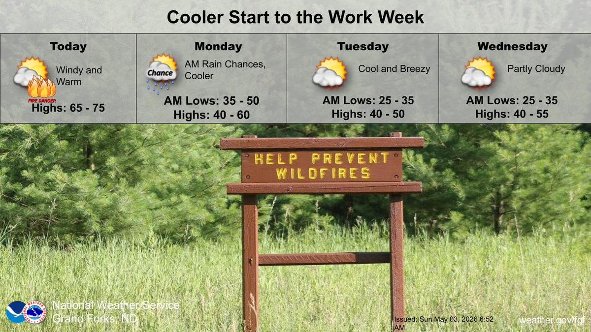
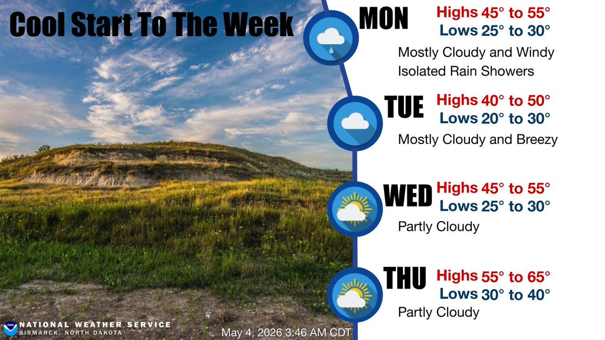
Back to the cool weather this first week of May. Highs 10-15 degrees below normal thru Wednesday. Windy today with isolated showers and northwest wind gusts to 35 mph over eastern ND and the Red River valley. Warmer by next weekend. #NDwx #MNwx

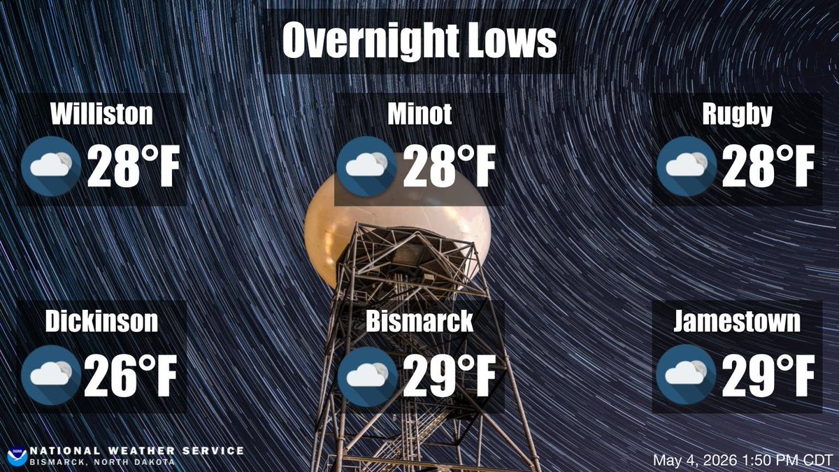
Below normal low temperatures in the 20s are forecast for tonight. Cool temperatures and mainly dry conditions will continue through mid week with highs in the 40s and 50s and lows in the 20s. #ndwx


There is an elevated fire weather risk today across parts of the northern Plains. Gusty winds (20-30mph) and very low humidity will create dry, fast-burning conditions, especially in parts of eastern MT into ND where Red Flag Warnings are in effect. #MTWx #NDwx #FireWX
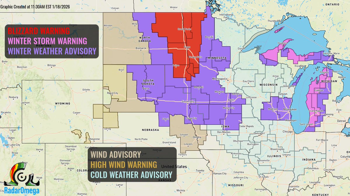
Moderate to heavy snow & icing continue across the Northern Plains into the Upper Midwest today. Snowfall rates of 1-2"/hr are possible in eastern ND into northern MN. Conditions improve tonight, though travel impacts will persist. #NDwx #SDwx #MNwx
A strong low pressure system will move across the northern Plains through the Great Lakes Basin and into Ontario/Quebec this week. The system will bring a myriad of impacts, including wintery precipitation and strong winds. #NDwx #SDwx #NEwx #IAwx #MNwx #WIwx #MIwx #NYwx #OHwx
Moments ago, Storm Chaser @tornadopaigeyy captured this view of the tornado-warned storm in central North Dakota. #NDwx @cyclonePORT
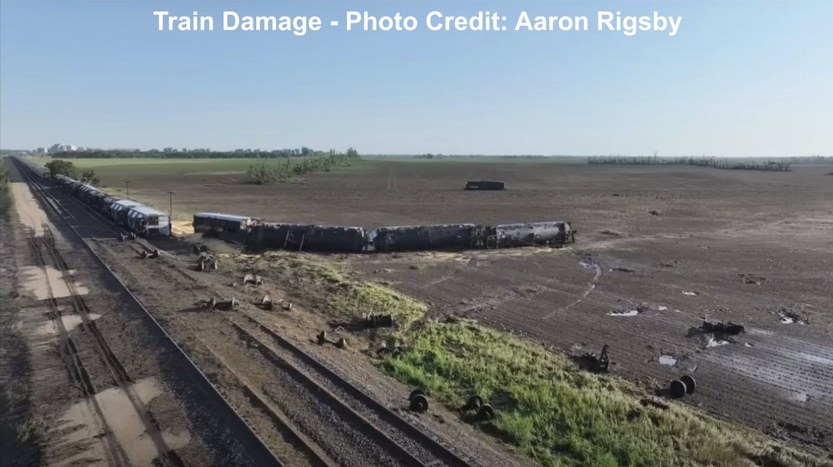
New Today: Forensic analysis of derailed train cars has determined that a tornado which occurred on June 20th this year near Enderlin, ND and Sheldon, ND produced winds exceeding 210 mph, making it the first official EF-5 since May 20, 2013. #NDwx

Storm Chaser Freddy McKinney captured this view of this storm just moments ago near Sheldon, North Dakota! #NDwx 📸 @FreddyMcKinneyR
Unseasonably warm today with a gusty south wind. Tonight into Thursday will see scattered showers and thunderstorms ahead of a cold front. Friday and Saturday cooler with highs mid 40s to mid 50s. #NDwx #MNwx
Snow showers and strong winds will spread from the Northern Plains into the Midwest this morning and afternoon. Wind gusts up to 60mph and whiteout conditions are possible in parts of ND into MN, where Blizzard Warnings are in effect. #NDwx #MNwx #SDwx
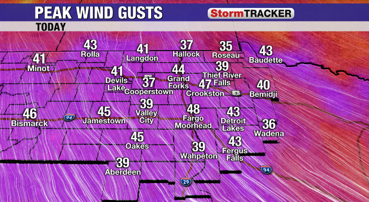
After a weekend in the 70s, today's blustery wind was insult to injury with those falling temperatures. The wind does gradually let up overnight, but tomorrow will still be cool and a bit breezy, with highs stuck in the 40s and a few sprinkles/flurries possible too. #ndwx #mnwx
The second batch of showers for today has developed across the northern valley. We've seen sprinkles in both Grand Forks and Devils Lake this afternoon. Don't expect much rain out of these, but it'll add on to the cool and damp conditions we have for the afternoon. #ndwx #mnwx
Below normal low temperatures in the 20s are forecast for tonight. Cool temperatures and mainly dry conditions will continue through mid week with highs in the 40s and 50s and lows in the 20s. #ndwx
The National Weather Service Office in Bismarck will begin issuing Frost Advisories, Freeze Watches and Freeze Warnings on Friday May 8th. #NDwx #NDag
Back to the cool weather this first week of May. Highs 10-15 degrees below normal thru Wednesday. Windy today with isolated showers and northwest wind gusts to 35 mph over eastern ND and the Red River valley. Warmer by next weekend. #NDwx #MNwx
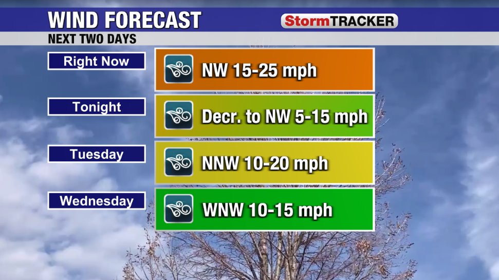
Expect a cool and windy start to your workweek. Highs will be mainly in the 40s and 50s today and Tuesday, with a gradual warm-up mid to late week. Look for isolated showers today with little or no precipitation expected Tuesday through Thursday. #NDwx #NDag
With a cold front passing through the region overnight, cooler weather is on tap to start the coming workweek. Luckily, a gradual warmup is then anticipated to bring us broadly back into the 60s by Friday. #NDwx
Critical fire weather conditions are active today across North Dakota, Montana, and Wyoming. Red Flag Warnings are in effect with westerly wind gusts up to 45 MPH and humidity dropping to 15%. Any fires that ignite will spread rapidly. #NDwx #MTwx #WYwx
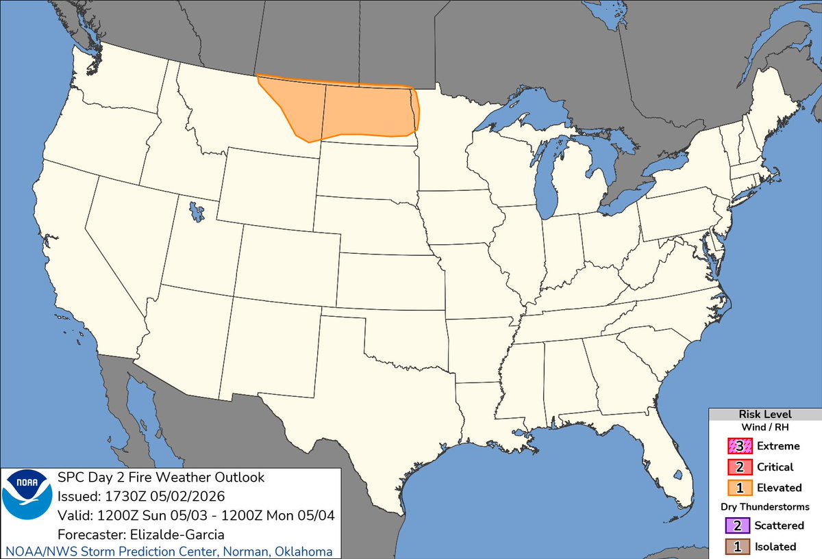
There is an elevated fire weather risk today across parts of the northern Plains. Gusty winds (20-30mph) and very low humidity will create dry, fast-burning conditions, especially in parts of eastern MT into ND where Red Flag Warnings are in effect. #MTWx #NDwx #FireWX
After a warm and windy Sunday, a cold front comes through tonight. A few light rain showers will come along with the front, but the main impacts will be a return to cooler temperatures. Highs will again be in the 40s and 50s with lows near or below freezing #NDwx #MNwx
Windy today with critical fire weather concerns. After an early week cooldown, we warm back up. #NDwx
However with that wind, we are tracking elevated fire conditions for another dry day across the region, so hold off on the fires for the evening. A few showers will slide through tonight, but no major chances for rain are coming until we get into mid-May. #ndwx #mnwx

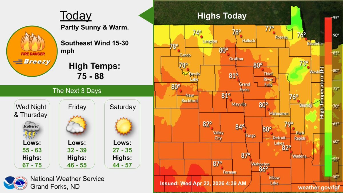
Hold on to your hat, but get out and enjoy the sun today! We have brilliant blue skies, with west winds for much of the day, & highs in the 70s. In typical spring fashion, the 70s aren't here for long, as a wind shift tonight brings in a cool-down to start the week. #ndwx #mnwx

Strong west winds of 25-30 mph with higher gusts along with relative humidity as low as 20 percent will lead to Red Flag conditions across NE and east central North Dakota today. Near critical conditions will be present for surrounding areas. #NDwx #MNwx

Fire weather concerns exist across the northern plains tomorrow given 20-30kt flow within a deep well mixed boundary layer featuring ~2km deep dry adiabatic lapse rates and sub-25% RH. #NDwx #MTwx

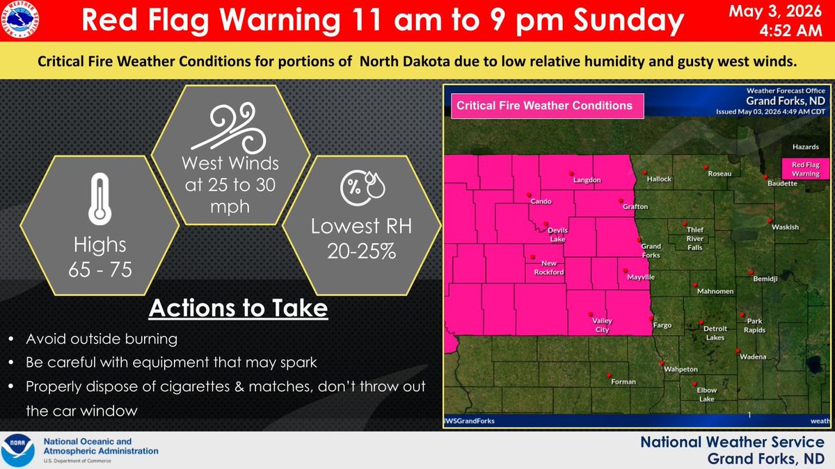
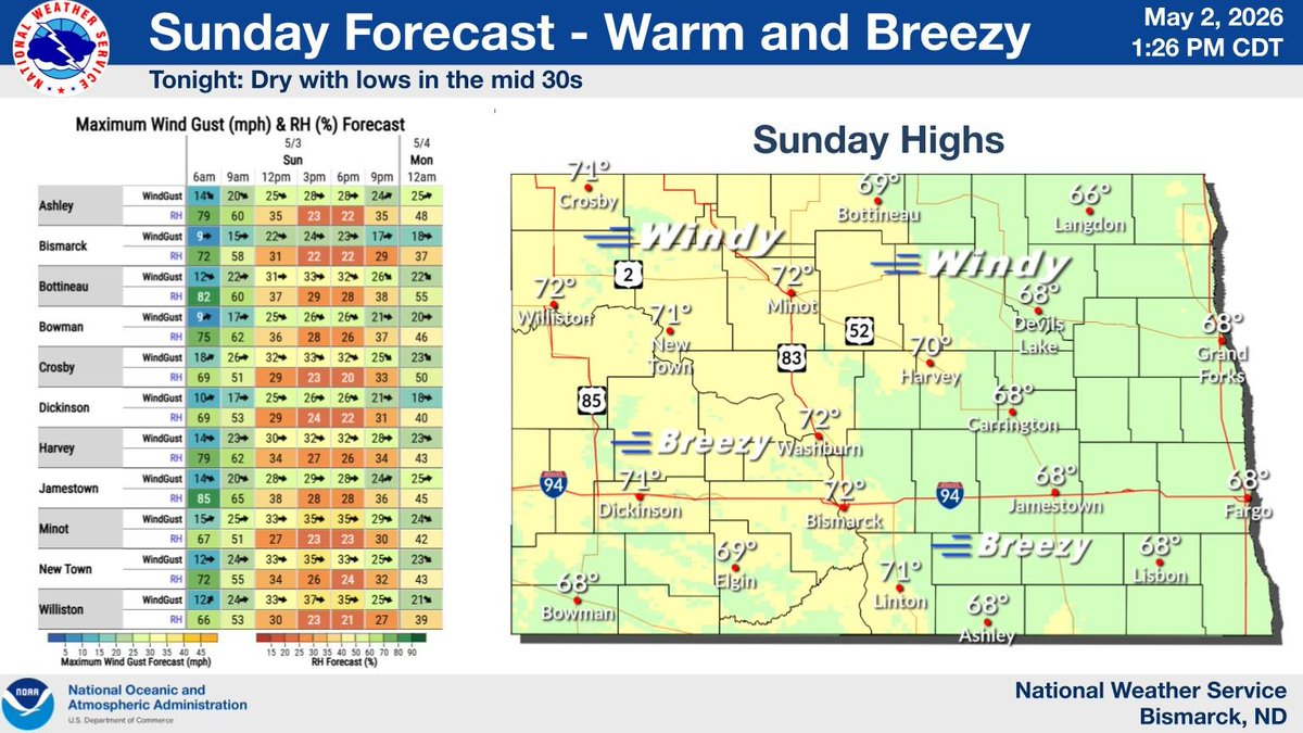
Strong west winds of 25-30 mph with gusts in the 30s along with relative humidity as low as 20 percent will lead to Red Flag conditions across northern and northeast North Dakota Sunday. Near critical conditions will be present for surrounding areas. #NDwx #MNwx
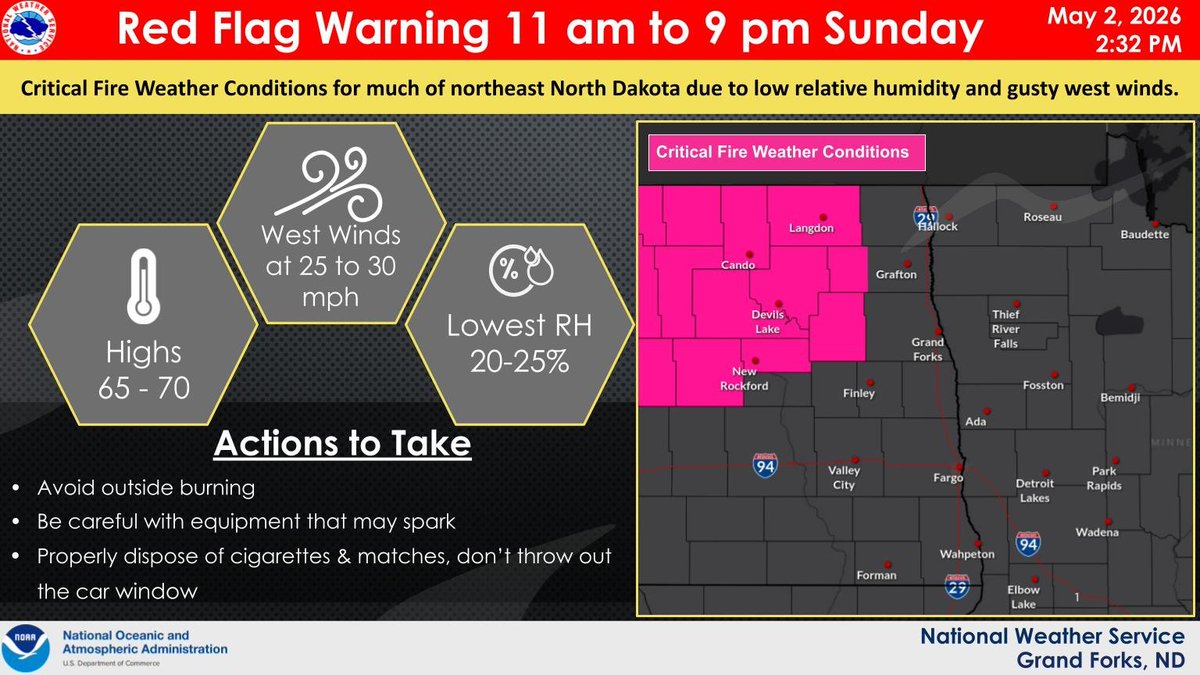
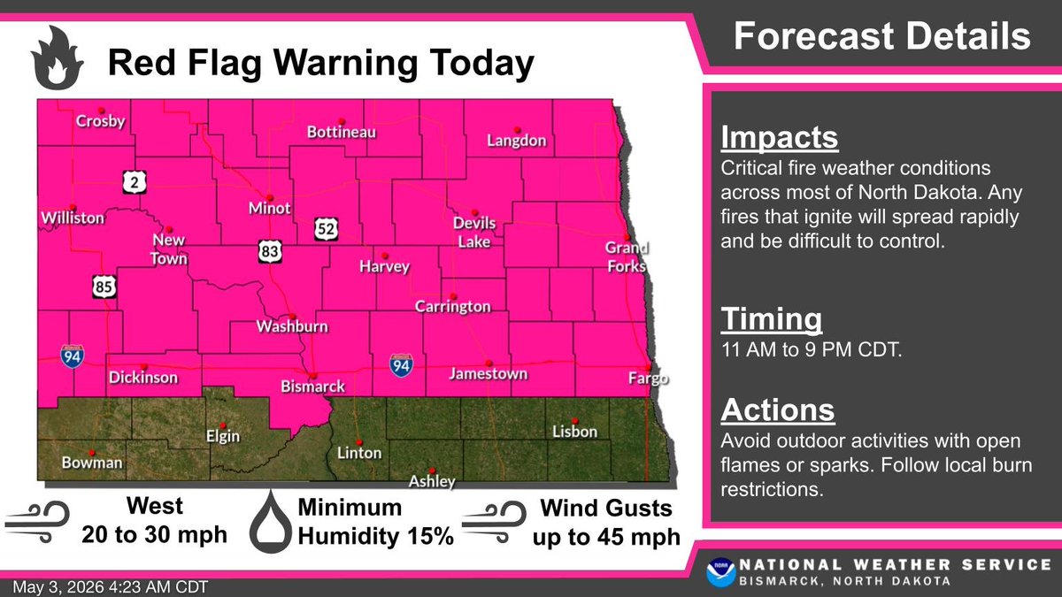
Critical fire weather conditions are expected late Sunday morning into the evening (11 am to 9 pm CDT) over most of northern and portions of southwestern ND. Use caution if outdoors on Sunday. Any fires that ignite will spread rapidly and become difficult to control. #NDwx #NDag
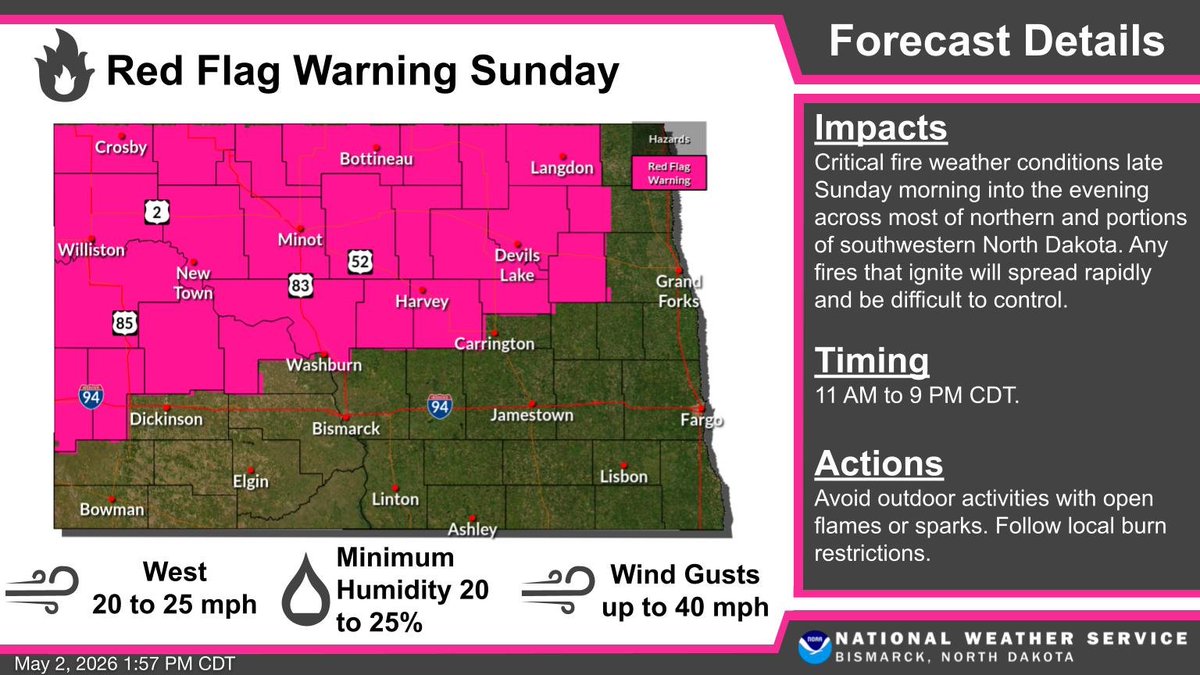
Warm and windy conditions expected again on Sunday with highs in the upper 60s to low 70s. The combination of strong winds and low relative humidity will result in critical fire weather conditions on Sunday over portions of northern and western North Dakota. #NDwx #NDag


New Today: Forensic analysis of derailed train cars has determined that a tornado which occurred on June 20th this year near Enderlin, ND and Sheldon, ND produced winds exceeding 210 mph, making it the first official EF-5 since May 20, 2013. #NDwx
Storm Chaser Freddy McKinney captured this view of this storm just moments ago near Sheldon, North Dakota! #NDwx 📸 @FreddyMcKinneyR
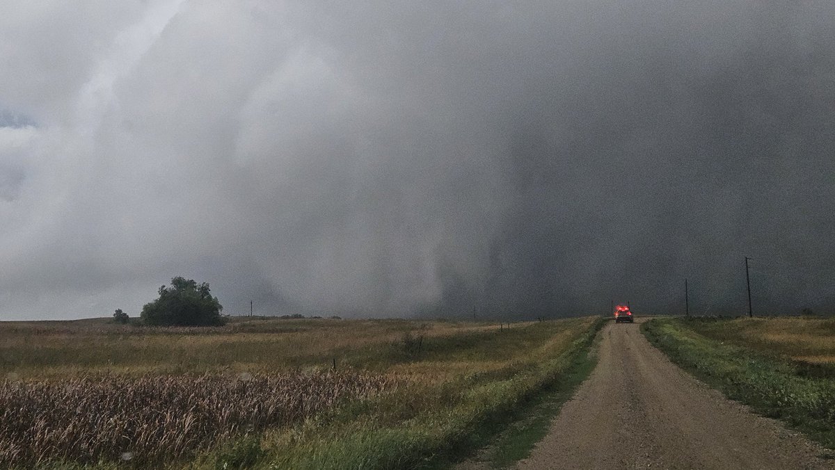
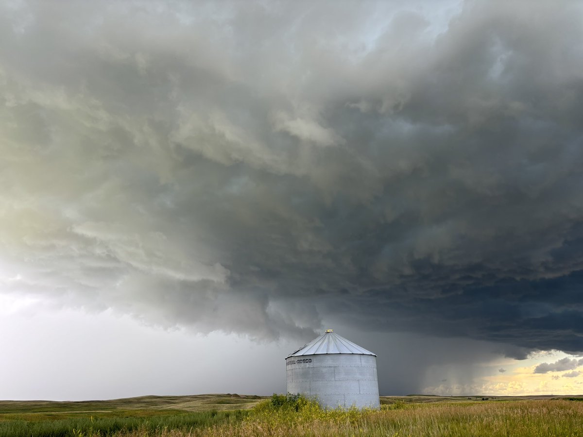
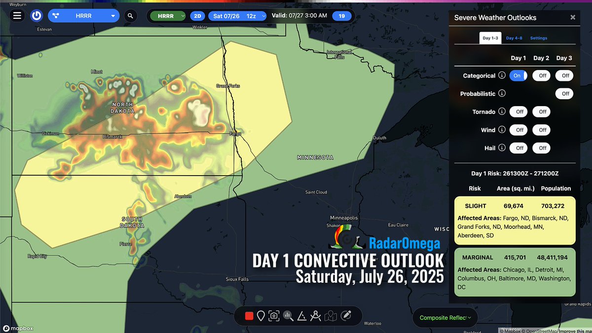
Tornadoes, large hail, and damaging wind swaths can be expected later today into tonight across North Dakota. SPC has outlined a level 3/5 enhanced risk of severe weather through early Friday morning. #NDwx


Severe Thunderstorm Warning continues for Belcourt ND, Rolla ND and Saint John ND until 6:15 PM CDT #NDwx


For those wondering, here is my full video flyover of the EF5 damage from the Enderlin, ND Tornado #NDwx youtu.be/HvqEJEy3EH8


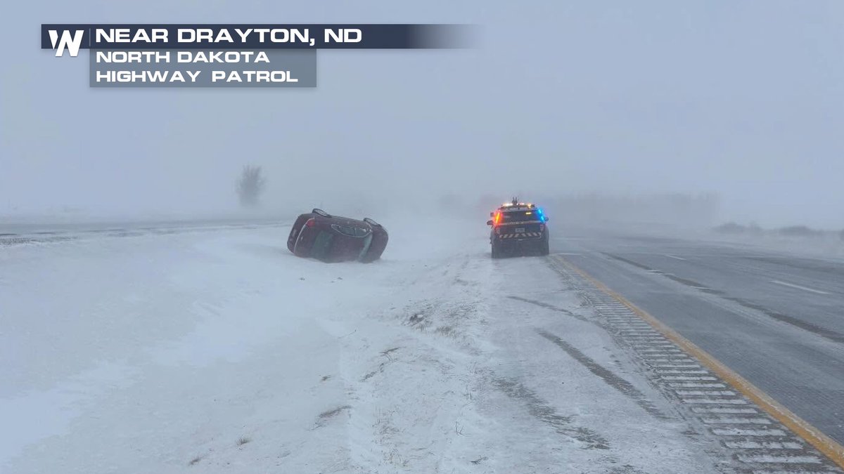
It is 🌬️W🌬️I🌬️N🌬️D🌬️Y🌬️ in the Great Plains today! Blowing snow in the Dakotas led to a flipped vehicle while intense winds in Colorado toppled a semi. The wind led to numerous road closures today. Check your route before you head out! #NDwx #COwx


Yesterday before showtime @JordanHallWX and I jokingly said "watch we somehow get Spaulding 2.0 today". Few hours later annndddd....#NDwx


It was a tad chilly this morning in the Midwest, eh? NO THANKS. It was FREEZING in the Midwest this morning with air temperatures more than 20 below zero for some. Another round of arctic air arrives this weekend: bit.ly/4iN6VJV #MNwx #WIwx #NDwx #ILwx

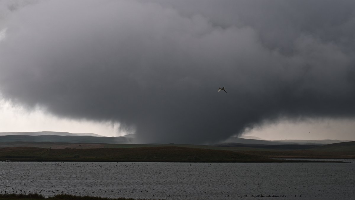
Here are some of the other tornadoes @JordanHallWX and I documented from Sunday in North Dakota including mega wedge North of Bismark #NDwx
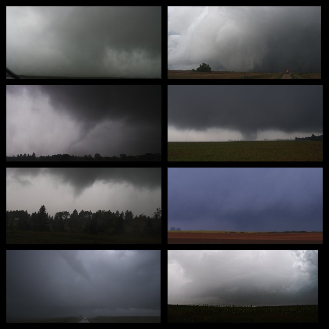


The second coming of Spalding just south of Denhoff, ND from @BrandonCopicWx. Structures have been hit as well unfortunately. #ndwx


In the wake of a cold front, temperatures will dip below freezing early Wednesday morning, with temperatures as low as 23ºF expected in northeastern North Dakota and northern Minnesota. Freeze Warnings are in place for these areas tonight! #NDwx #MNwx #WIwx #MIwx


Something went wrong.
Something went wrong.
United States Trends
- 1. Wemby N/A
- 2. Spurs N/A
- 3. Spurs N/A
- 4. #MetGala N/A
- 5. Mike Conley N/A
- 6. Anthony Edwards N/A
- 7. Mitch Johnson N/A
- 8. #WWERaw N/A
- 9. Julius Randle N/A
- 10. Lacombe N/A
- 11. Michael Conforto N/A
- 12. Knicks N/A
- 13. Keldon Johnson N/A
- 14. Victor Wembanyama N/A
- 15. Castle N/A
- 16. Pagan N/A
- 17. Champagnie N/A
- 18. De'Aaron Fox N/A
- 19. #bucciovertimechallenge N/A
- 20. Dylan Harper N/A