#osdatahub search results


Many thanks @OrdnanceSurvey for your #PSGA update at today's online @cadcorp #LocalGovernment conference. PSGA members are certainly going to benefit from the new #OSDataHub #PublicSector Plan #GIS

@OrdnanceSurvey GB Data online training for #GIS professionals | Learn how to use the #OSDataHub in #CadcorpSIS | Still chance to book your place - mailchi.mp/cadcorp.com/on…

@cadcorp software supports @OrdnanceSurvey data products, in a wide variety of data supply formats, in as simple a way as possible. We showed how #OSDataHub APIs are supported within #SISDesktop to our online #Fire Service Analysis workshop delegates cdcp.io/frs20p #GIS
@OrdnanceSurvey GB Data training | Learn how to access the #OSDataHub in #CadcorpSIS mailchi.mp/cadcorp.com/tr… #APIs #GIS


Discover how location data helps the NHS London Healthy Urban Development Unit ensure that everyone has access to the healthcare they need, and avoid inconsistent health site address records. ow.ly/7lIL50I74Yq #SeeABetterPlace #OSDataHub

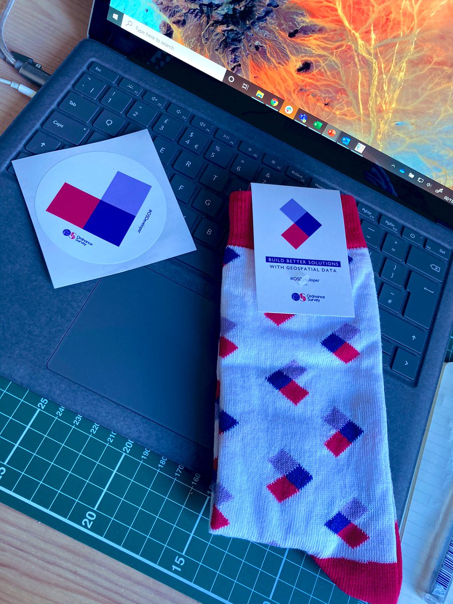
Integrate up-to-date, detailed maps in your applications to make location-based decisions with confidence. Explore OS Data Hub: ow.ly/BHcR50I21MH #OSDeveloper #OSDataHub

Currently demo'ing how to master @OrdnanceSurvey data, including #OSNGD via the #OSDataHub, at this morning's online @Cadcorp #LocalGovernment Conference - #GIS #Spatialinsight


@OrdnanceSurvey Expands as a Distributor of Third-party Government Data #OSDataHub #OpenData #GeoNews shorturl.at/7rr0u


Great insights! @BOkuyiga re @GeospatialC @JoshGilbertUK re Geospatial 2.0 @Seraphimspace re inv space tech @I_am_LisaAllen re @OrdnanceSurvey provision incl #OSDataHub osdatahub.os.uk Ch @acoote #EverythingHappensSomewhere #GIS #ThePowerofPlace: bit.ly/TPOPlive

✅ SIS 9.1 Service Release: Significantly broadens data format compatibility within #SISDesktop. @cadcorp is an @OrdnanceSurvey Premium Partner and support has been added for the OS MasterMap™ Topography Layer supplied in #OGC GeoPackage format accessible from the #OSDataHub ...

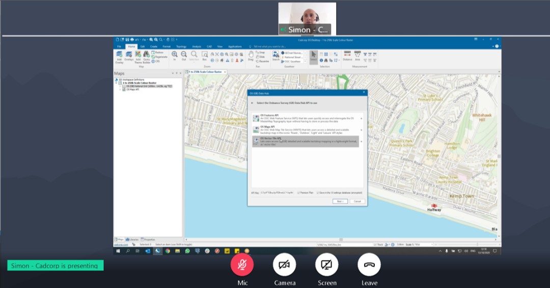
As part of the syllabus for the @cadcorp SIS & @OrdnanceSurvey GB Data training, attendees learnt how to load #OSMM Building Height data from the #OSDataHub, filter buildings using a selected flood zone and visualise the data within a 3D window cdcp.io/training #GIS

Missed our webinar with @OrdnanceSurvey for #PSGA members? It covered using #OSAPIs, via the #OSDataHub in a #GIS. View the recording here: ow.ly/pnLe50DP9C6
Learn more about the @OrdnanceSurvey #OSDataHub in @Cadcorp SIS - Still time to register for this #OnlineTraining course - mailchi.mp/cadcorp.com/tr… - #GIS
.@OrdnanceSurvey GB Data #OnlineTraining 2nd August | Still time to register - mailchi.mp/cadcorp.com/tr… #OSdataHub #GIS

⌛ Still time to book your place - Learn how to access the #OSDataHub with @OrdnanceSurvey GB Data #OnlineTraining - mailchi.mp/cadcorp.com/tr… - #GIS #Spatialinsight

Want to gain insight into managing @OrdnanceSurvey major datasets and accessing the #OSDataHub from within #SISDesktop and #SISWebMap? Register for next month's training course - mailchi.mp/cadcorp.com/tr… #GIS

Latest Service Release for @Cadcorp SIS 9.1 includes support for @OrdnanceSurvey #OSNGD API – Tiles via the #OSDataHub, and enhanced data from the OS Emergency Services Gazetteer #OSESG - bit.ly/3ycwkdl - #GIS #Spatialinsight


Check out "OS Data Hub Explained" eventbrite.co.uk/e/os-data-hub-… @EventbriteUK @Geovation @OrdnanceSurvey #OSDataHub
✅ SIS 9.1 Service Release - further support for ordnance survey #OSNGD API - Features within cadcorp SIS Desktop. Extract Transport Network or Water Network data from the #OSDataHub and seamlessly build a topological network bit.ly/3Zg3vWp #GIS #Spatialinsight

Learn more about the @OrdnanceSurvey #OSDataHub in @Cadcorp SIS - Still time to register for this #OnlineTraining course - mailchi.mp/cadcorp.com/tr… - #GIS
⌛ Still time to book your place - Learn how to access the #OSDataHub with @OrdnanceSurvey GB Data #OnlineTraining - mailchi.mp/cadcorp.com/tr… - #GIS #Spatialinsight
Currently demo'ing how to master @OrdnanceSurvey data, including #OSNGD via the #OSDataHub, at this morning's online @Cadcorp #LocalGovernment Conference - #GIS #Spatialinsight
Latest Service Release for @Cadcorp SIS 9.1 includes support for @OrdnanceSurvey #OSNGD API – Tiles via the #OSDataHub, and enhanced data from the OS Emergency Services Gazetteer #OSESG - bit.ly/3ycwkdl - #GIS #Spatialinsight
@OrdnanceSurvey Expands as a Distributor of Third-party Government Data #OSDataHub #OpenData #GeoNews shorturl.at/7rr0u
✅ SIS 9.1 Service Release: Significantly broadens data format compatibility within #SISDesktop. @cadcorp is an @OrdnanceSurvey Premium Partner and support has been added for the OS MasterMap™ Topography Layer supplied in #OGC GeoPackage format accessible from the #OSDataHub ...
✅ SIS 9.1 Service Release - further support for ordnance survey #OSNGD API - Features within cadcorp SIS Desktop. Extract Transport Network or Water Network data from the #OSDataHub and seamlessly build a topological network bit.ly/3Zg3vWp #GIS #Spatialinsight
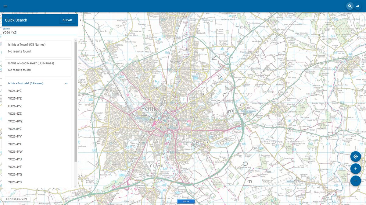
Cadcorp SIS 9.1 is here | #SISWebmap Quick Search allows for fuzzy searches and free access to @ordnancesurvey #OSDataHub APIs. What else is new? cdcp.io/sis9-1 #SIS9.1 #MakingSenseofPlace #spatialinsight #GIS
Want to gain insight into managing @OrdnanceSurvey major datasets and accessing the #OSDataHub from within #SISDesktop and #SISWebMap? Register for next month's training course - mailchi.mp/cadcorp.com/tr… #GIS
.@OrdnanceSurvey GB Data #OnlineTraining 2nd August | Still time to register - mailchi.mp/cadcorp.com/tr… #OSdataHub #GIS
"How do I...❓" The @OrdnanceSurvey #OSDataHub provides a number of different API to serve data. The OS Maps API uses a WMTS and is ideal for background mapping in @cadcorp #SISWebMap ow.ly/9A0050IbQk0 #GIS
Discover how location data helps the NHS London Healthy Urban Development Unit ensure that everyone has access to the healthcare they need, and avoid inconsistent health site address records. ow.ly/7lIL50I74Yq #SeeABetterPlace #OSDataHub
Integrate up-to-date, detailed maps in your applications to make location-based decisions with confidence. Explore OS Data Hub: ow.ly/BHcR50I21MH #OSDeveloper #OSDataHub
@OrdnanceSurvey GB Data training | Learn how to access the #OSDataHub in #CadcorpSIS mailchi.mp/cadcorp.com/tr… #APIs #GIS
As part of the syllabus for the @cadcorp SIS & @OrdnanceSurvey GB Data training, attendees learnt how to load #OSMM Building Height data from the #OSDataHub, filter buildings using a selected flood zone and visualise the data within a 3D window cdcp.io/training #GIS
@OrdnanceSurvey GB Data online training for #GIS professionals | Learn how to use the #OSDataHub in #CadcorpSIS | Still chance to book your place - mailchi.mp/cadcorp.com/on…
Missed our webinar with @OrdnanceSurvey for #PSGA members? It covered using #OSAPIs, via the #OSDataHub in a #GIS. View the recording here: ow.ly/pnLe50DP9C6
Many thanks @OrdnanceSurvey for your #PSGA update at today's online @cadcorp #LocalGovernment conference. PSGA members are certainly going to benefit from the new #OSDataHub #PublicSector Plan #GIS

Great progress from @OrdnanceSurvey making APIs available to a number of datasets through #OSDataHub. The pandemic highlighted the importance of collobration, and the APIs provide a new way to access & work with OS #data. @UKAuthority okt.to/Iy3Tlq #CivicaNorthStar
@OrdnanceSurvey GB Data online training for #GIS professionals | Learn how to use the #OSDataHub in #CadcorpSIS | Still chance to book your place - mailchi.mp/cadcorp.com/on…
@OrdnanceSurvey GB Data training | Learn how to access the #OSDataHub in #CadcorpSIS mailchi.mp/cadcorp.com/tr… #APIs #GIS
@OrdnanceSurvey Expands as a Distributor of Third-party Government Data #OSDataHub #OpenData #GeoNews shorturl.at/7rr0u
Learn more about the @OrdnanceSurvey #OSDataHub in @Cadcorp SIS - Still time to register for this #OnlineTraining course - mailchi.mp/cadcorp.com/tr… - #GIS
Great insights! @BOkuyiga re @GeospatialC @JoshGilbertUK re Geospatial 2.0 @Seraphimspace re inv space tech @I_am_LisaAllen re @OrdnanceSurvey provision incl #OSDataHub osdatahub.os.uk Ch @acoote #EverythingHappensSomewhere #GIS #ThePowerofPlace: bit.ly/TPOPlive
Currently demo'ing how to master @OrdnanceSurvey data, including #OSNGD via the #OSDataHub, at this morning's online @Cadcorp #LocalGovernment Conference - #GIS #Spatialinsight
Many thanks @OrdnanceSurvey for your #PSGA update at today's online @cadcorp #LocalGovernment conference. PSGA members are certainly going to benefit from the new #OSDataHub #PublicSector Plan #GIS
⌛ Still time to book your place - Learn how to access the #OSDataHub with @OrdnanceSurvey GB Data #OnlineTraining - mailchi.mp/cadcorp.com/tr… - #GIS #Spatialinsight
Discover how location data helps the NHS London Healthy Urban Development Unit ensure that everyone has access to the healthcare they need, and avoid inconsistent health site address records. ow.ly/7lIL50I74Yq #SeeABetterPlace #OSDataHub
@cadcorp software supports @OrdnanceSurvey data products, in a wide variety of data supply formats, in as simple a way as possible. We showed how #OSDataHub APIs are supported within #SISDesktop to our online #Fire Service Analysis workshop delegates cdcp.io/frs20p #GIS
Integrate up-to-date, detailed maps in your applications to make location-based decisions with confidence. Explore OS Data Hub: ow.ly/BHcR50I21MH #OSDeveloper #OSDataHub
As part of the syllabus for the @cadcorp SIS & @OrdnanceSurvey GB Data training, attendees learnt how to load #OSMM Building Height data from the #OSDataHub, filter buildings using a selected flood zone and visualise the data within a 3D window cdcp.io/training #GIS
Missed our webinar with @OrdnanceSurvey for #PSGA members? It covered using #OSAPIs, via the #OSDataHub in a #GIS. View the recording here: ow.ly/pnLe50DP9C6
Latest Service Release for @Cadcorp SIS 9.1 includes support for @OrdnanceSurvey #OSNGD API – Tiles via the #OSDataHub, and enhanced data from the OS Emergency Services Gazetteer #OSESG - bit.ly/3ycwkdl - #GIS #Spatialinsight
.@OrdnanceSurvey GB Data #OnlineTraining 2nd August | Still time to register - mailchi.mp/cadcorp.com/tr… #OSdataHub #GIS
Want to gain insight into managing @OrdnanceSurvey major datasets and accessing the #OSDataHub from within #SISDesktop and #SISWebMap? Register for next month's training course - mailchi.mp/cadcorp.com/tr… #GIS
✅ SIS 9.1 Service Release: Significantly broadens data format compatibility within #SISDesktop. @cadcorp is an @OrdnanceSurvey Premium Partner and support has been added for the OS MasterMap™ Topography Layer supplied in #OGC GeoPackage format accessible from the #OSDataHub ...
Cadcorp SIS 9.1 is here | #SISWebmap Quick Search allows for fuzzy searches and free access to @ordnancesurvey #OSDataHub APIs. What else is new? cdcp.io/sis9-1 #SIS9.1 #MakingSenseofPlace #spatialinsight #GIS
✅ SIS 9.1 Service Release - further support for ordnance survey #OSNGD API - Features within cadcorp SIS Desktop. Extract Transport Network or Water Network data from the #OSDataHub and seamlessly build a topological network bit.ly/3Zg3vWp #GIS #Spatialinsight
Something went wrong.
Something went wrong.
United States Trends
- 1. Sonny Gray 3,242 posts
- 2. #yummymeets N/A
- 3. Dick Fitts N/A
- 4. #GMMTV2026 4.51M posts
- 5. Red Sox 4,061 posts
- 6. Brandon Clarke N/A
- 7. Thankful 51K posts
- 8. #csm221 3,188 posts
- 9. National Treasure 4,015 posts
- 10. #OurCosmicClue_Wooyoung 25.4K posts
- 11. Happy Thanksgiving 19K posts
- 12. Gone in 60 1,240 posts
- 13. Chaim N/A
- 14. Giolito N/A
- 15. Mark Kelly 253K posts
- 16. Hegseth 121K posts
- 17. Raising Arizona N/A
- 18. Mainz Biomed N/A
- 19. Yoshida 4,509 posts
- 20. Joe Ryan N/A