#pinnaclefire search results

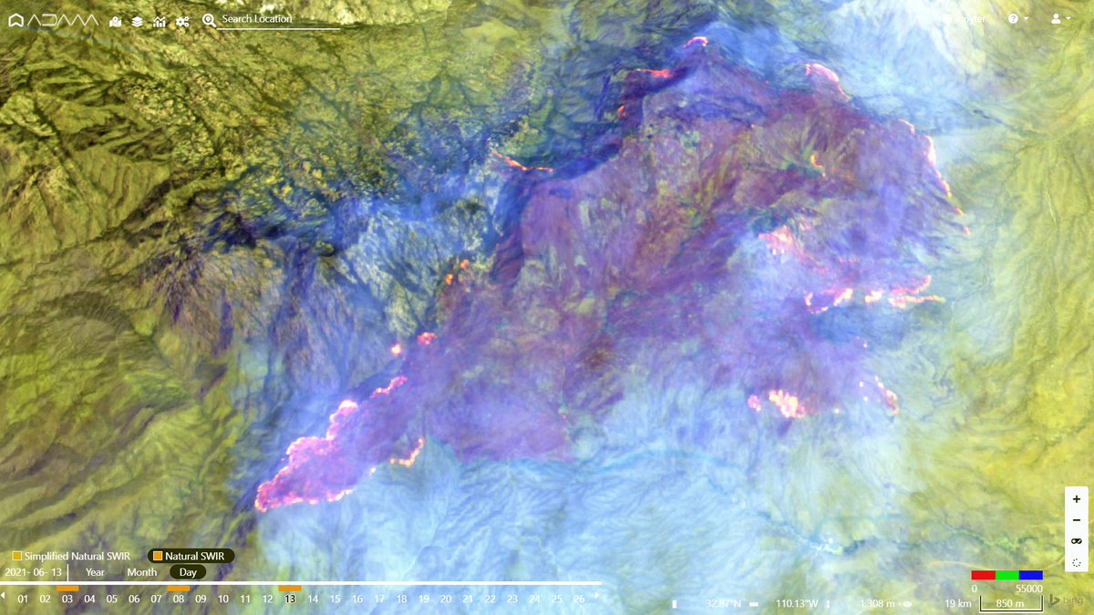
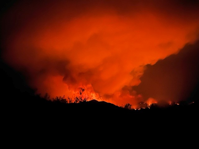
An impressive #Copernicus #Sentinel2 image of #Pinnaclefire, #Arizona. Currently estimated being 9.911 acres, the fire keeps growing. #AZFire @Bewickwren @LaurentAlfonso @RobMayeda #wildfire #AZWX #Pinnacle

#PinnacleFire #AZ #AZCNF bit.ly/3w701p7 Pinnacle Fire: BLM Rescinds Closures Related to Pinnacle Fire
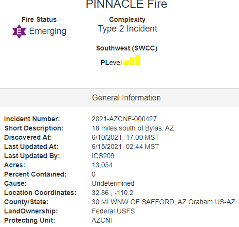
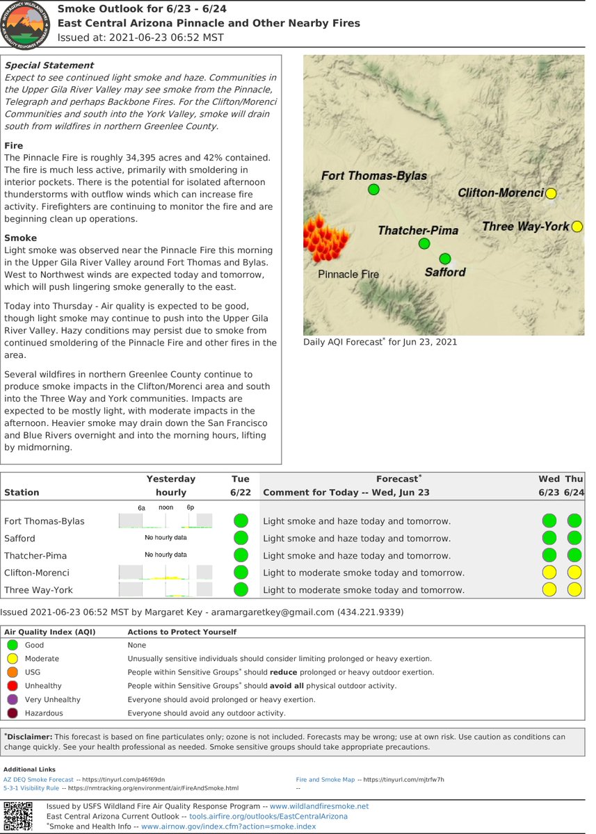
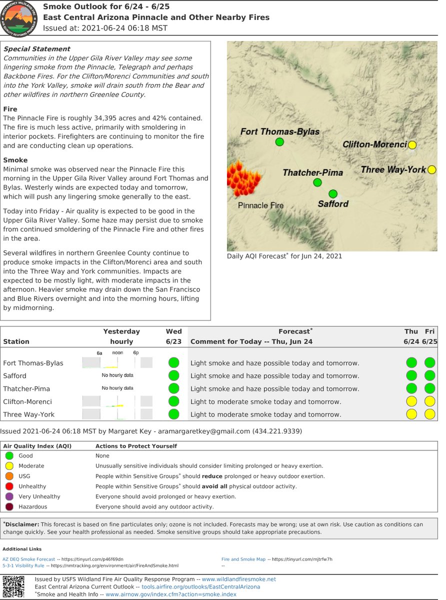
GID - #PinnacleFire: Fire is approx. 34,395 acres, 42% contained. See today's update on Pinnacle Fire Info. Facebook page: facebook.com/PinnacleFireIn… or on Inciweb: inciweb.nwcg.gov/incident/7523/ #AZFire


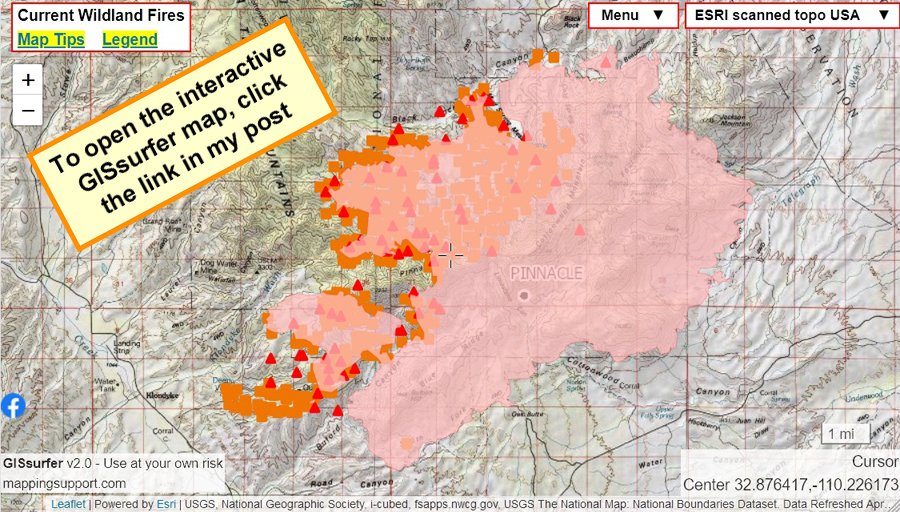
Thursday June 17. #PinnacleFire AZ 25,805 acres as of 10:37pm infrared flight yesterday. Map lets you turn on/off/restack lots of #GIS layers. Top layer is clickable. Need help? See 2 links upper left corner. #AZfire #AZwx Open #GISsurfer map: bit.ly/3guDfmm
#PinnacleFire #AZ #AZCNF bit.ly/3zjdPzC Pinnacle Fire: Pinnacle Fire 100% contained at 3PM July 16\, 2021.
GID - #PinnacleFire: Fire approx. 34,395 acres 42% contained. See full update: facebook.com/PinnacleFireIn… or on Inciweb: inciweb.nwcg.gov/incident/7523/ #AZFire


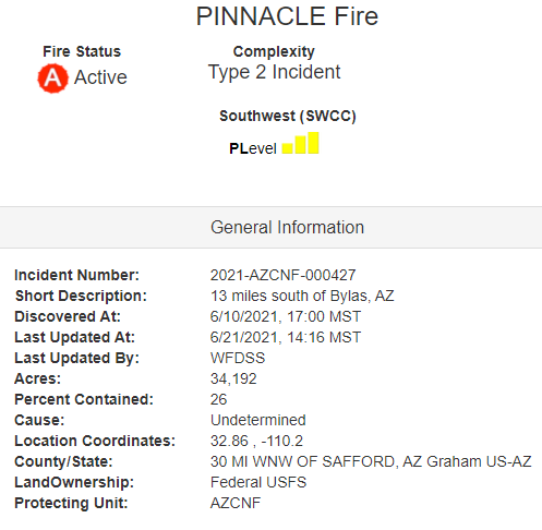
Red Flag conditions today on the #PinnacleFire 🚩 Currently 34,192 acres and 26% contained. More info at 👇 inciweb.nwcg.gov/incident/artic… @CoronadoNF @BLMAZFire @azstateforestry #AZFire
#PinnacleFire #AZ #AZCNF bit.ly/3iFqZky Pinnacle Fire: new maps have been uploaded to this incident
#PinnacleFire #AZ #AZCNF bit.ly/3dfPyRt Pinnacle Fire: BLM to Lift Closure Order on Sunday
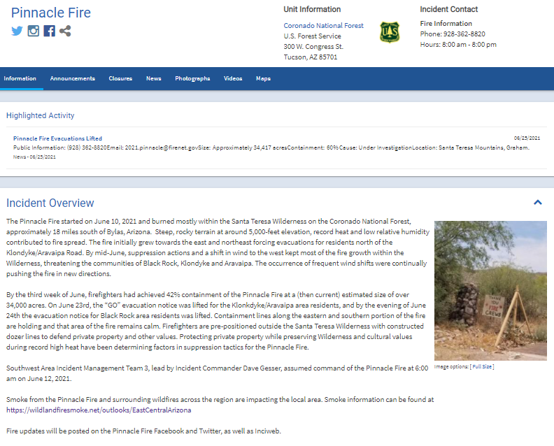
#PinnacleFire #AZ #AZCNF bit.ly/3zjdPzC Pinnacle Fire: The Pinnacle Fire started on June 10\, 2021 and burned mostly within the San
GID - #PinnacleFire: Fire is approximately 31,715 acres, 25% contained. See full update on Pinnacle Fire Info. Facebook page: facebook.com/PinnacleFireIn… or on Inciweb: inciweb.nwcg.gov/incident/7523/


#PinnacleFire #AZ #AZCNF bit.ly/2T4LjkT Pinnacle Fire: Pinnacle Fire BAER Team Ordered
#PinnacleFire #AZ #AZCNF bit.ly/2U6cmwp Pinnacle Fire: Command Changes for Pinnacle Fire
#PinnacleFire #AZ #AZCNF bit.ly/3wM3Ocp Pinnacle Fire: June 23 Update on Status of Evacuations
#PinnacleFire #AZ #AZCNF bit.ly/2TVdhiZ Pinnacle Fire: new photos have been uploaded to this incident

#Pinnaclefire No information has been provided, hotspot satellite data shows activity on the east and south sides
#Pinnaclefire No new information has been provided, hotspot satellite data shows activity on the east sides
#pinnaclefire fire activity has remained minimal due to extensive efforts made by crews, today cold trailing work will continue to prevent fire from reigniting recent hotspot satellite date shows fire activity on the east side
No important information has been provided on the #pinnaclefire updates will release when information becomes available
#Pinnaclefire Today crews across the perimeter continue to reinforce control lines and work on chipping operations, around illahe crews are working on structural protection and line reinforcement
#Pinnaclefire Today crews are continuing to engage with the fire on the east side near East creek and stair creek on the northeast side dozers have completed lines going from the rogue river to August knob
#Pinnaclefire Today crews on the southwest side are working on snagging operations where hotspots have been detected, near bushy bar crews are working on cold trialing going 100 feet deep into the perimeter
#pinnaclefire Yesterday crews engaged with Fire activity on the west side which remained elevated, on the east side hotshot crews are worked on tying lines already built around the southeastern edge recent hotspot satellite data shows the fire burning along the western side
#pinnaclefire Yesterday increased fire weather conditions led to elevated fire behavior, recent hotspot satellite data shows the burning on the southwest side crews are using water drops and direct attack actions for suppression efforts
#pinnaclefire Yesterday crews managed to make good progress on containment on the western side, today crews will continue mop up operations around and through the perimeter and near half moon lodge
#pinnaclefire today on the south side crews have begun working on building lines west of service road 127 on the western side crews will work to establish a line on the river
#pinnaclefire Yesterday crews engaged the fire on the east side near stair creek slowing rates of spread, today water drops along rogue river moderated behavior while on the south side crews continue to work on reinforcing lines along service road 127
#pinnaclefire Yesterday more crews arrived on the north side of the fire for fire line scouting operations, on the southern side crews ran into unexpected fire activity forcing them to switch tactics crews have begun preparing service roads 490 and 491
#pinnaclefire Yesterday crews completed preparations on service road 127 on the southern edge crews began direct tactics on the fire, crews lined the fire near the bushy bar area as fire activity slowed down and mop up and snagging operations continued
#pinnaclefire Yesterday Crews have began working to open service road 127 and 700 for moving further equipment transport, today crews completed structural preparations around half moon lodge.
The #pinnaclefire Yesterday rainy conditions allowed crews to hold the fire north of bear camp road, today crews will continue working on structural protection and fire line work, the fire is actively pushing southwest threatening camp sites.

#PinnacleFire #AZ #AZCNF bit.ly/3zjdPzC Pinnacle Fire: The Pinnacle Fire has received some precipitation. Containment is at 90%.
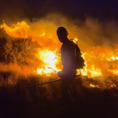
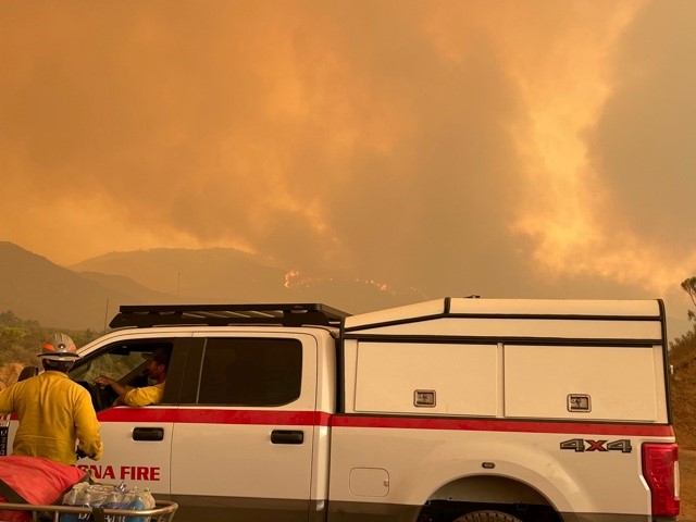
@SedonaFD has resources deployed on wildfires around the state including the #PinnacleFire and the #TelegraphFire. Here are a few photos courtesy of our REMS team deployed near Globe. #SedonaFD @SedonaFD @azfamily @CBS5 @12news @fox10Phoenix @abc15


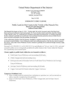
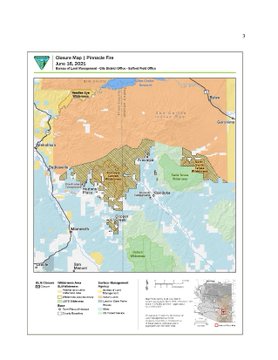
GID - #PinnacleFire: The Safford Field Office has issued a closure order for Aravaipa Canyon Wilderness and other BLM managed lands in the vicinity of the fire. See the full order and map for details on Inciweb: inciweb.nwcg.gov/incident/artic…

GID - #PinnacleFire: Fire approx. 34,395 acres 42% contained. See full update: facebook.com/PinnacleFireIn… or on Inciweb: inciweb.nwcg.gov/incident/7523/ #AZFire
An impressive #Copernicus #Sentinel2 image of #Pinnaclefire, #Arizona. Currently estimated being 9.911 acres, the fire keeps growing. #AZFire @Bewickwren @LaurentAlfonso @RobMayeda #wildfire #AZWX #Pinnacle

#BackboneFire | Same Conditions as earlier | Most air resources were allocated to several other fires in Arizona as of now with the most major relocation effort being on the #pinnaclefire and #walnutfire | Super Scoopers dropping on major hotspots near Strawberry and now West

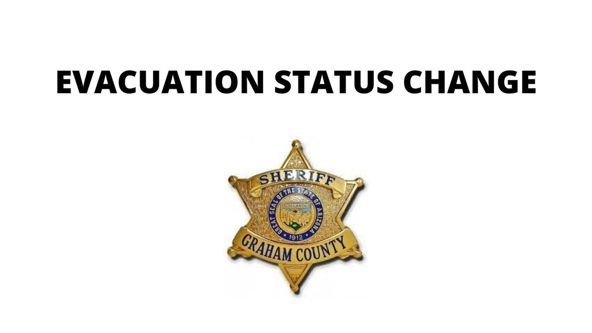
GID - #PinnacleFire: Graham County Sheriff's Office updated evacuation status for the entire communities of Klondyke and Aravaipa to "GO." More information on fire, evacuation status and closures on Inciweb: inciweb.nwcg.gov/incident/7523/ #AZFire
GID - #PinnacleFire: Fire is approx. 34,395 acres, 42% contained. See today's update on Pinnacle Fire Info. Facebook page: facebook.com/PinnacleFireIn… or on Inciweb: inciweb.nwcg.gov/incident/7523/ #AZFire
0916 06232021: #Update Fire activity on the #PinnacleFire declines. 34,395 acres/42% contained. Firefighters continue to mop up and monitor. Chipping brush and repairing roads is starting today. #AZFire Thank you @PinnacleInfo21 for updates!
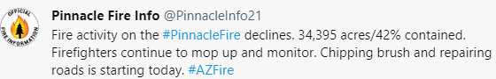
Fire activity on the #PinnacleFire declines. 34,395 acres/42% contained. Firefighters continue to mop up and monitor. Chipping brush and repairing roads is starting today. #AZFire inciweb.nwcg.gov/incident/artic… @CoronadoNF @BLMAZFire @azstateforestry
GID - #PinnacleFire: Fire currently approximately 34,192 acres, 26% contained. See the latest complete update on Pinnacle Fire Info. Facebook page: facebook.com/PinnacleFireIn… or on Inciweb: inciweb.nwcg.gov/incident/7523/ #AZFire

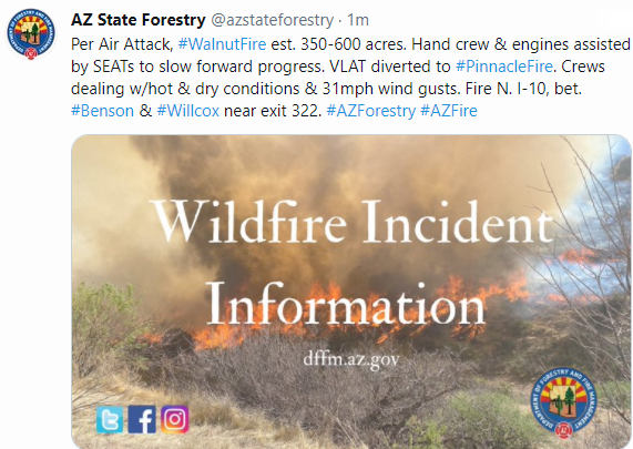
1408:Per Air Attack, #WalnutFire est. 350-600 acres. Hand crew & engines assisted by SEATs to slow forward progress. VLAT diverted to #PinnacleFire. Crews dealing w/hot & dry conditions & 31mph wind gusts. Fire N. I-10, bet. #Benson & #Willcox near exit 322. #AZForestry #AZFire

2054: Per @PinnacleInfo21: BLMArizona has issued a #ClosureOrder for the North Santa Teresa Wilderness and Aravaipa Canyon Wilderness and other surrounding BLM lands. #knowbeforeyougo #PinnacleFire
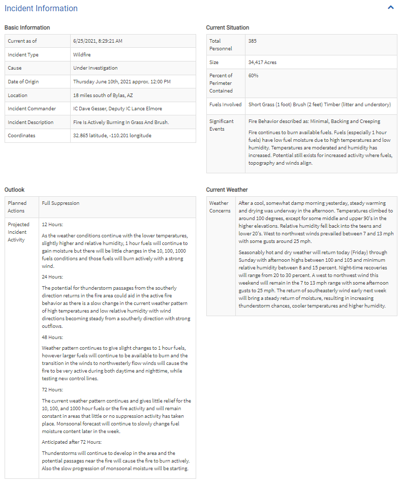
0829 06252021: #AzFire #PinnacleFire #Update 34,417Acres 60%Containment inciweb.nwcg.gov/incident/7523/
GID - #PinnacleFire: Fire is approximately 31,715 acres, 25% contained. See full update on Pinnacle Fire Info. Facebook page: facebook.com/PinnacleFireIn… or on Inciweb: inciweb.nwcg.gov/incident/7523/
Air quality expected to be good, though light smoke may continue to push into the Upper Gila River Valley. Hazy conditions may persist due to #PinnacleFire wildlandfiresmoke.net/outlooks/EastC…
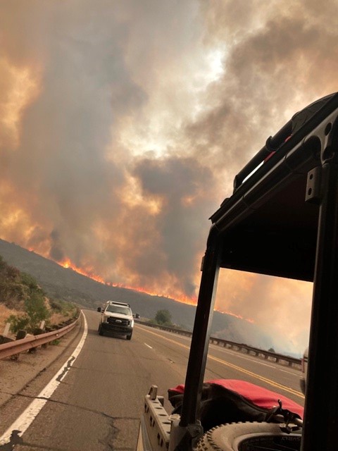
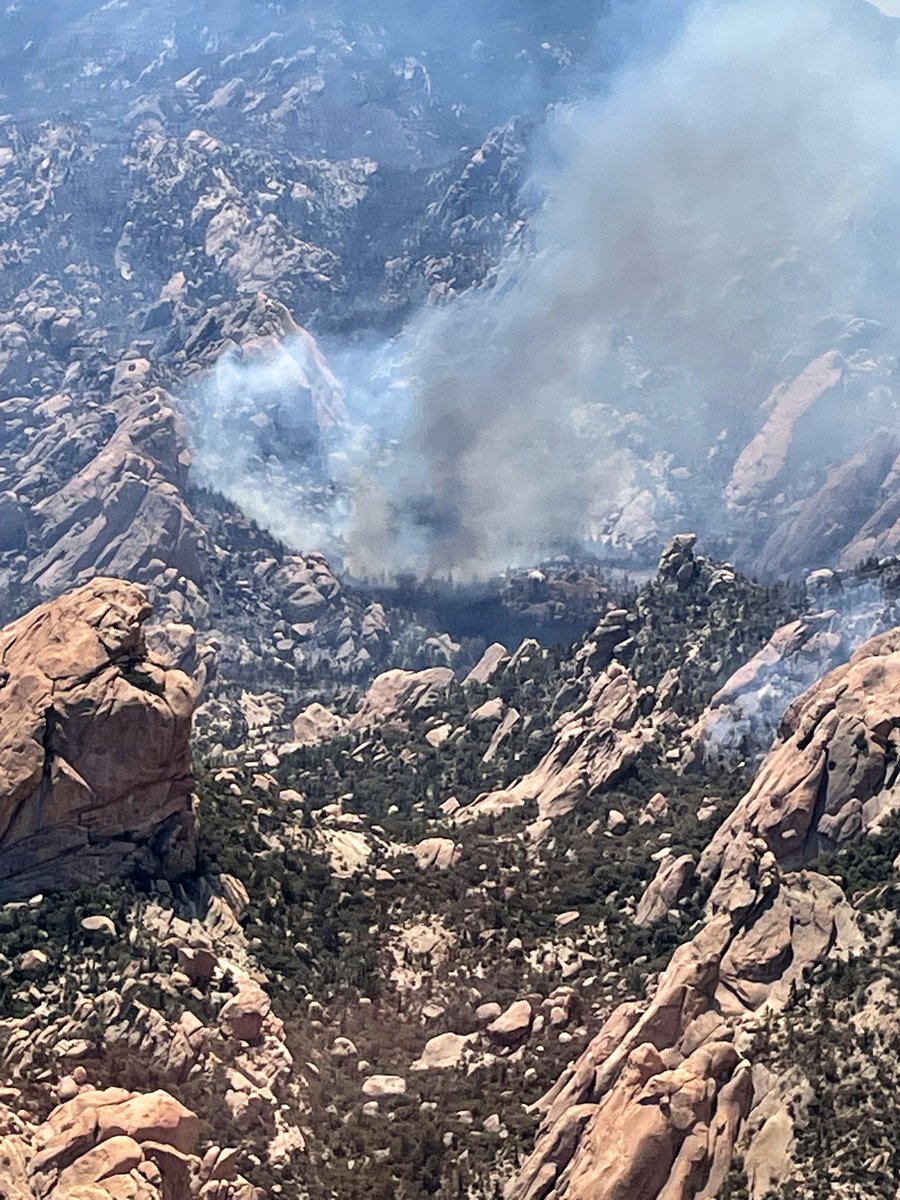
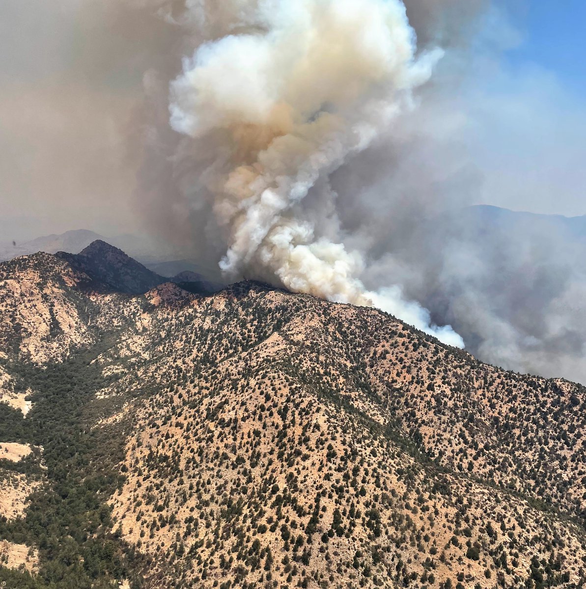
Aerial recon photos taken this morning on the #PinnacleFire show burning in steep, rocky terrain within the Wilderness. Stay up on the latest: inciweb.nwcg.gov/incident/7523/ #AZFire

The Graham County Sheriff's Office has lifted evacuations for Black Rock. Residents may return home. 👏 #PinnacleFire #AZFire @GrahamCounty
Today into Friday - Air quality is expected to be good in the Upper Gila River Valley. Some haze may persist due to smoke from continued smoldering of the Pinnacle Fire and other fires in the area. #pinnaclefire wildlandfiresmoke.net/outlooks/EastC…
Something went wrong.
Something went wrong.
United States Trends
- 1. robby N/A
- 2. #thepitt N/A
- 3. #911onABC N/A
- 4. langdon N/A
- 5. #TNAiMPACT N/A
- 6. Samira N/A
- 7. Gudas N/A
- 8. Pritchard N/A
- 9. eddie N/A
- 10. garcia N/A
- 11. ROTC N/A
- 12. #kisscostreamingparty N/A
- 13. #TexasHockey N/A
- 14. Strickland N/A
- 15. becca N/A
- 16. Baron Corbin N/A
- 17. Brandon Shah N/A
- 18. Duke N/A
- 19. Hubert Davis N/A
- 20. Saturday in the Park N/A