#simultaneouslocalizationandmapping ผลการค้นหา

2) A Review of Visual-#LiDAR Fusion based #SimultaneousLocalizationandMapping mdpi.com/1424-8220/20/7… #camera #vision #mapping #localization
1) A Review of Visual-LiDAR Fusion based #SimultaneousLocalizationandMapping 👉mdpi.com/1424-8220/20/7… #SLAM #mapping #localization #LiDAR #camera #vision
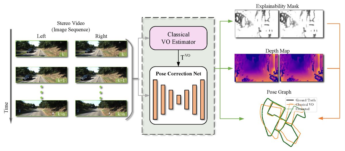
#highlycitedpaper Stereo Visual Odometry Pose Correction through Unsupervised Deep Learning mdpi.com/1424-8220/21/1… #SimultaneousLocalizationandMapping #unsupervisedDeepLearning #visualodometry
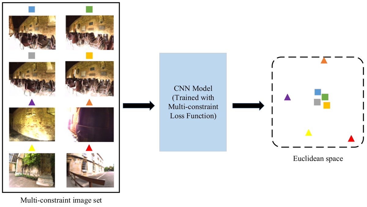
#mostviewspaper Towards a Robust Visual Place Recognition in Large-Scale vSLAM Scenarios Based on a Deep Distance Learning mdpi.com/1424-8220/21/1… #SimultaneousLocalizationandMapping #ConvolutionalNeuralNetworks
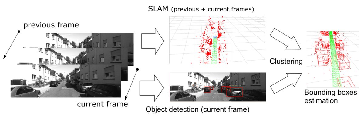
#highlycitedpaper SLAM-OR: Simultaneous Localization, Mapping and Object Recognition Using Video Sensors Data in Open Environments from the Sparse Points Cloud mdpi.com/1424-8220/21/1… #simultaneouslocalizationandmapping #objectsrecognition #deeplearning #sparsepointcloud
#highlycitedpaper LeGO-LOAM-SC: An Improved Simultaneous Localization and Mapping Method Fusing LeGO-LOAM and Scan Context for Underground Coalmine mdpi.com/1424-8220/22/2… #simultaneouslocalizationandmapping #scancontext #loopdetection #ICPgraphoptimization #unmannedvehicle
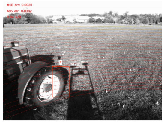
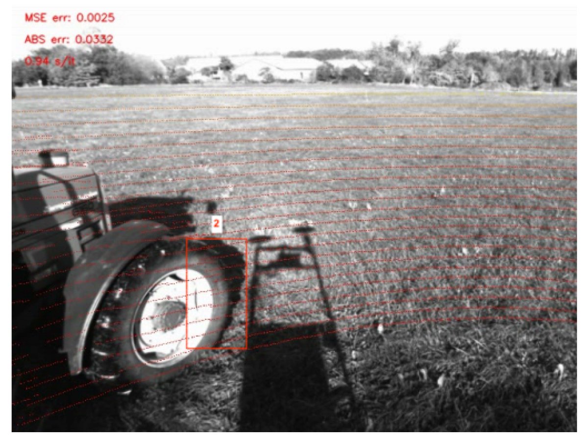
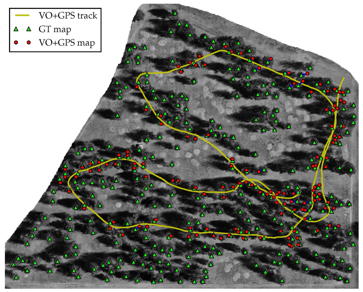
Vision-Aided Localization and Mapping in Forested Environments Using Stereo Images mdpi.com/1424-8220/23/1… @OregonState #simultaneouslocalizationandmapping #computervision; #GNSS #GPS

Come on and SLAM welcome to the space jam #simultaneouslocalizationandmapping

Robley is a robot that can retrace a route simply by watching a prerecorded video of it: bit.ly/2s22yBP
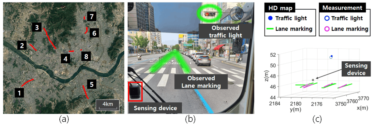
Vehicle Localization Using Crowdsourced Data Collected on Urban Roads mdpi.com/1424-8220/24/1… @UniversityKorea #vehiclelocalization; #crowdsourceddata; #simultaneouslocalizationandmapping

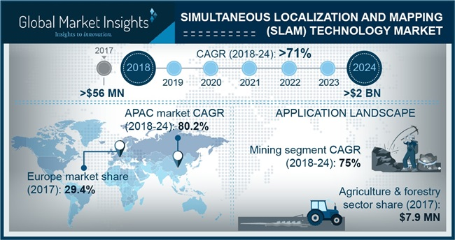
SLAM Technology Market to cross $2bn by 2024 For More Details: bit.ly/2NJLdIj #SimultaneousLocalizationandMapping #Technology #Market

Researchers from @UDelaware describe a robust technique for visual-inertial #SLAM from monocular cameras. ieeexplore.ieee.org/document/10609… #SimultaneousLocalizationAndMapping #RobotSensingSystems #VisualInertial


Worlds first and only Lightweight Realtime SLAM. Boots up in 2 seconds! 4-15 times faster than competition. Entire stack runs on a mere 300 Mhz MCU while... linkedin.com/posts/simultan… #simultaneouslocalizationandmapping #simultaneouslocalizationand #mappingSLAM #patents
Happy New Year Team Back In India goo.gl/6XMwg0 #Simultaneouslocalizationandmapping #Vancouver #NewJersey #Canada #UnitedStates lm

Worlds first and only Lightweight Realtime SLAM. Boots up in 2 seconds! 4-15 times faster than competition. Entire stack runs on a mere 300 Mhz MCU while... linkedin.com/posts/simultan… #simultaneouslocalizationandmapping #simultaneouslocalizationand #mappingSLAM #patents
Worlds first and only Lightweight Realtime SLAM. Boots up in 2 seconds! 4-15 times faster than competition. Entire stack runs on a mere 300 Mhz MCU while... linkedin.com/posts/simultan… #simultaneouslocalizationandmapping #simultaneouslocalizationand #mappingSLAM #patents

Read more globenewswire.com/news-release/2… #SimultaneousLocalizationandMapping (SLAM) #Technology Market is estimated to reach USD 2 billion by 2024 Key companies- @SkydioHQ @smprobotics @viametris @wikitude #SLAMtechnology #SLAM #NorthAmerica #LatinAmerica #Europe
Simultaneous Localization & Mapping Technology Market to hit $2bn by 2024 @Facebook @Google @Microsoft globenewswire.com/news-release/2… #SimultaneousLocalizationandMapping #SLAM #Technology Market is estimated to reach USD 2 billion by 2024
Vehicle Localization Using Crowdsourced Data Collected on Urban Roads mdpi.com/1424-8220/24/1… @UniversityKorea #vehiclelocalization; #crowdsourceddata; #simultaneouslocalizationandmapping
Researchers from @UDelaware describe a robust technique for visual-inertial #SLAM from monocular cameras. ieeexplore.ieee.org/document/10609… #SimultaneousLocalizationAndMapping #RobotSensingSystems #VisualInertial
Vision-Aided Localization and Mapping in Forested Environments Using Stereo Images mdpi.com/1424-8220/23/1… @OregonState #simultaneouslocalizationandmapping #computervision; #GNSS #GPS
#highlycitedpaper LeGO-LOAM-SC: An Improved Simultaneous Localization and Mapping Method Fusing LeGO-LOAM and Scan Context for Underground Coalmine mdpi.com/1424-8220/22/2… #simultaneouslocalizationandmapping #scancontext #loopdetection #ICPgraphoptimization #unmannedvehicle
#highlycitedpaper SLAM-OR: Simultaneous Localization, Mapping and Object Recognition Using Video Sensors Data in Open Environments from the Sparse Points Cloud mdpi.com/1424-8220/21/1… #simultaneouslocalizationandmapping #objectsrecognition #deeplearning #sparsepointcloud
#highlycitedpaper Stereo Visual Odometry Pose Correction through Unsupervised Deep Learning mdpi.com/1424-8220/21/1… #SimultaneousLocalizationandMapping #unsupervisedDeepLearning #visualodometry
#mostviewspaper Towards a Robust Visual Place Recognition in Large-Scale vSLAM Scenarios Based on a Deep Distance Learning mdpi.com/1424-8220/21/1… #SimultaneousLocalizationandMapping #ConvolutionalNeuralNetworks
1) A Review of Visual-LiDAR Fusion based #SimultaneousLocalizationandMapping 👉mdpi.com/1424-8220/20/7… #SLAM #mapping #localization #LiDAR #camera #vision
2) A Review of Visual-#LiDAR Fusion based #SimultaneousLocalizationandMapping mdpi.com/1424-8220/20/7… #camera #vision #mapping #localization

#SLAM #mobilerobot #SimultaneousLocalizationAndMapping #ROS #Robot #Robotics #robotica #LocalizacionYMapeoSimultaneo
Worlds first and only Lightweight Realtime SLAM. Boots up in 2 seconds! 4-15 times faster than competition. Entire stack runs on a mere 300 Mhz MCU while... linkedin.com/posts/simultan… #simultaneouslocalizationandmapping #simultaneouslocalizationand #mappingSLAM #patents
Worlds first and only Lightweight Realtime SLAM. Boots up in 2 seconds! 4-15 times faster than competition. Entire stack runs on a mere 300 Mhz MCU while... linkedin.com/posts/simultan… #simultaneouslocalizationandmapping #simultaneouslocalizationand #mappingSLAM #patents
Worlds first and only Lightweight Realtime SLAM. Boots up in 2 seconds! 4-15 times faster than competition. Entire stack runs on a mere 300 Mhz MCU while... linkedin.com/posts/simultan… #simultaneouslocalizationandmapping #simultaneouslocalizationand #mappingSLAM #patents
Simultaneous Localization & Mapping Technology Market to hit $2bn by 2024 @Facebook @Google @Microsoft globenewswire.com/news-release/2… #SimultaneousLocalizationandMapping #SLAM #Technology Market is estimated to reach USD 2 billion by 2024
Read more globenewswire.com/news-release/2… #SimultaneousLocalizationandMapping (SLAM) #Technology Market is estimated to reach USD 2 billion by 2024 Key companies- @SkydioHQ @smprobotics @viametris @wikitude #SLAMtechnology #SLAM #NorthAmerica #LatinAmerica #Europe
SLAM Technology Market to cross $2bn by 2024 For More Details: bit.ly/2NJLdIj #SimultaneousLocalizationandMapping #Technology #Market
Come on and SLAM welcome to the space jam #simultaneouslocalizationandmapping
Robley is a robot that can retrace a route simply by watching a prerecorded video of it: bit.ly/2s22yBP

Bridging data & localization in the age of multilingual AI: centific.com/blog/bridging-… #MultilingualAI #Localization #MultilingualAI #Localization


someone just painted this over the whole map on wplace ‼️‼️🤯🤯


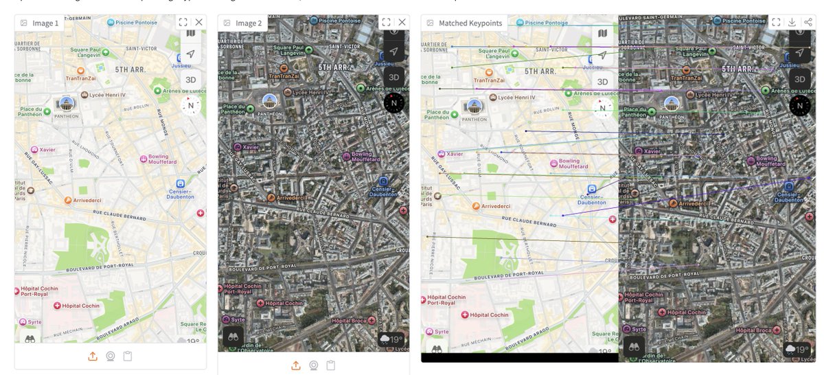
you can use DINOv3 for keypoint matching 😏 I got asked a lot so I built an app where you can try multiple DINOv3 models for matching features between images 🦖 for instance here's DINOv3 matching street view vs map ⤵️

Immersive view in @GoogleMaps is a new way to experience what a neighborhood, landmark, restaurant and venue will be like — and even feel like you’re right there. It uses advances in computer vision and AI to fuse together billions of Street View images. #GoogleIO

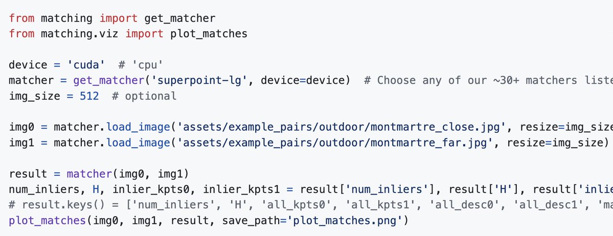
At ICCV I met people working on Image Matching who still don't know our image-matching-models GitHub repo It allows you to use almost any IM model just by changing one parameter Image matchers, try it out, it will save you countless hours github.com/alexstoken/ima…

#ご当地Nouns #LocalNouns #Nouns ⌐◨-◨ #AIart 【山形県】イモニ×サクランボ


これまで応援してくださった皆様 本当にありがとうございます🙏✨ この価格改定で 『もっとたくさんの人と地域を繋ぐ🤝』という本来の目的に、また一歩近づけると信じています。 皆様のおかげです。 これからも一緒に、この物語を育てていけたら嬉しいです🌱🚀 #ご当地Nouns 🗾 ⌐◨-◨

Dual Maps es una herramienta ideal para investigaciones en mapas, ya que ofrece una visión periférica utilizando Google Maps, Birds Eye Imagery y Google Street View. Se puede utilizar en diversas áreas y rubros, como: 1. Vigilancia y seguimiento: Permite el monitoreo en tiempo…


Mapflow: digitalización automática de imágenes con #QGIS. Mapflow proporciona rutinas de mapeo baso en inteligencia artificial para extraer: 🏡 Edificios 🌲 Zonas forestales 🏗️Construcciones 🚜 Campos agrícolas 🚗Carreteras mappinggis.com/2024/01/mapflo…


Multicam blending on Indonesian environment and Malvinas camo


Online tools for determining geolocation by photo: agent.earthkit.app (GeoClip + Google Lens) earthkit.app geospy.ai or usersearch.ai GeoSpy integration picarta.ai labs.tib.eu/geoestimation/ #osint #geoint

Happy to see MeshVPR being acknowledged here Believe it or not, using a mesh-based map is one of the most scalable ways to create an image localization system Anyone who came to the demo and tried it on their own photos would know this I still remember the shock on many…

Google and ETH have joined the large scale localization effort with a banger I really did not expect this And now I'm really hoping to make it to NeurIPS where the paper will be presented I'll read it and report a summary here in the next few days

osm-search.bellingcat.com A tool for locating photos and satellite images: Specify the objects you see and the distance between them (ex: a 10-story building 80 meters from a park). Select a search area (ex: a district of a city) Get a list of places that fit the description.


Result: there is a *fixed*, human-invisible map you can add to *any* image, and it renders it unclassifiable by multiple DL systems


movie of the year

someone just painted this over the whole map on wplace ‼️‼️🤯🤯

叢林溯溪越野之旅 4 Off-roading through jungle streams * Images: Fig 1 - Qwen Image Fig 2 - Microsoft MAI-Image-1 Fig 3 - Google Imagen 4 Ultra Fig 4 - Ideogram 3.0


Local SEO Tip: You can use DevTools "Sensors" functionality + Google Maps coordinates to emulate searches from any location that you want: Oftentimes when you're analyzing search results, you want to see how they look in a particular location. You might be analyzing search…


OSINT TIP #309📸 Picarta.ai - Image Geolocalization using Artificial Intelligence. The AI model predicts the precise location of where the photo was taken in the world🌍 🔗picarta.ai @Picarta_ai 👏 #OSINT

We recently launched multisearch in the Google app, which lets you search by taking a photo and asking a question at the same time. Later this year, you'll be able to take a picture or screenshot and add "near me" to get local results. #GoogleIO
Something went wrong.
Something went wrong.
United States Trends
- 1. Virginia 465K posts
- 2. #DWTS 37.7K posts
- 3. New York 869K posts
- 4. Sixers 12.2K posts
- 5. Bulls 32.3K posts
- 6. Mamdani 1.09M posts
- 7. Embiid 5,834 posts
- 8. Jay Jones 86.3K posts
- 9. Cuomo 372K posts
- 10. Andy 62.9K posts
- 11. #Election2025 14.1K posts
- 12. Josh Giddey 4,577 posts
- 13. Whitney 10.9K posts
- 14. Louisville 125K posts
- 15. #SeeRed 2,958 posts
- 16. Alix 7,091 posts
- 17. WOKE IS BACK 22.4K posts
- 18. RIP NYC 11.6K posts
- 19. Sherrill 99.5K posts
- 20. Danielle 9,478 posts