#unosat نتائج البحث

#UNOSAT joined the Consultative Workshop on ''Climate Displacement'' by #NISA Cambodia & SPP Chiang Mai University, sharing insights on using geospatial tech to map displacement risk and a case study from #Thailand. #SPPCMU #climatedisplacement


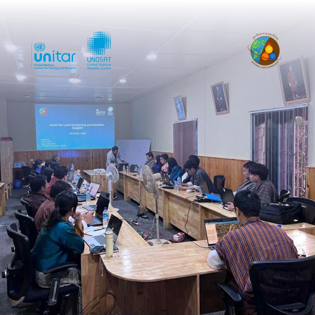
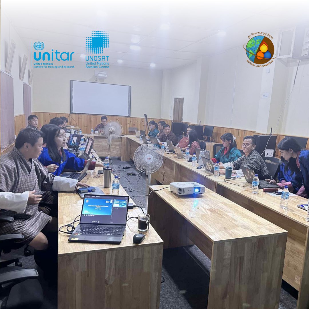
We’re excited and proud to launch our new #GeoAI Training on Land Monitoring in #Bhutan 🇧🇹, co-organized with our long-term partner @nlcsbhutan — empowering national experts with advanced tools such as deep learning and super-resolution. #UNOSAT #RemoteSensing #Training

Our session 745 (Remote Sensing) of #EAA kicking off with a presentation from Dr Michelle De Gruchy from #UNOSAT
#UNOSAT led Session 12 of the ESCAP–SIAP & @UN_Women Training on Big Data & Data Science for Gender Statistics in Asia and the Pacific, showing how satellite data helps reveal gender-based exposure to disasters.


During APSCO’s Disaster Response Workshop, we presented our Emergency Mapping Service and shared how geospatial analysis supports humanitarian response through Flood AI and the 2025 Myanmar earthquake case. #UNOSAT #APSCO #FloodAI #DisasterResponse #Geospatial @


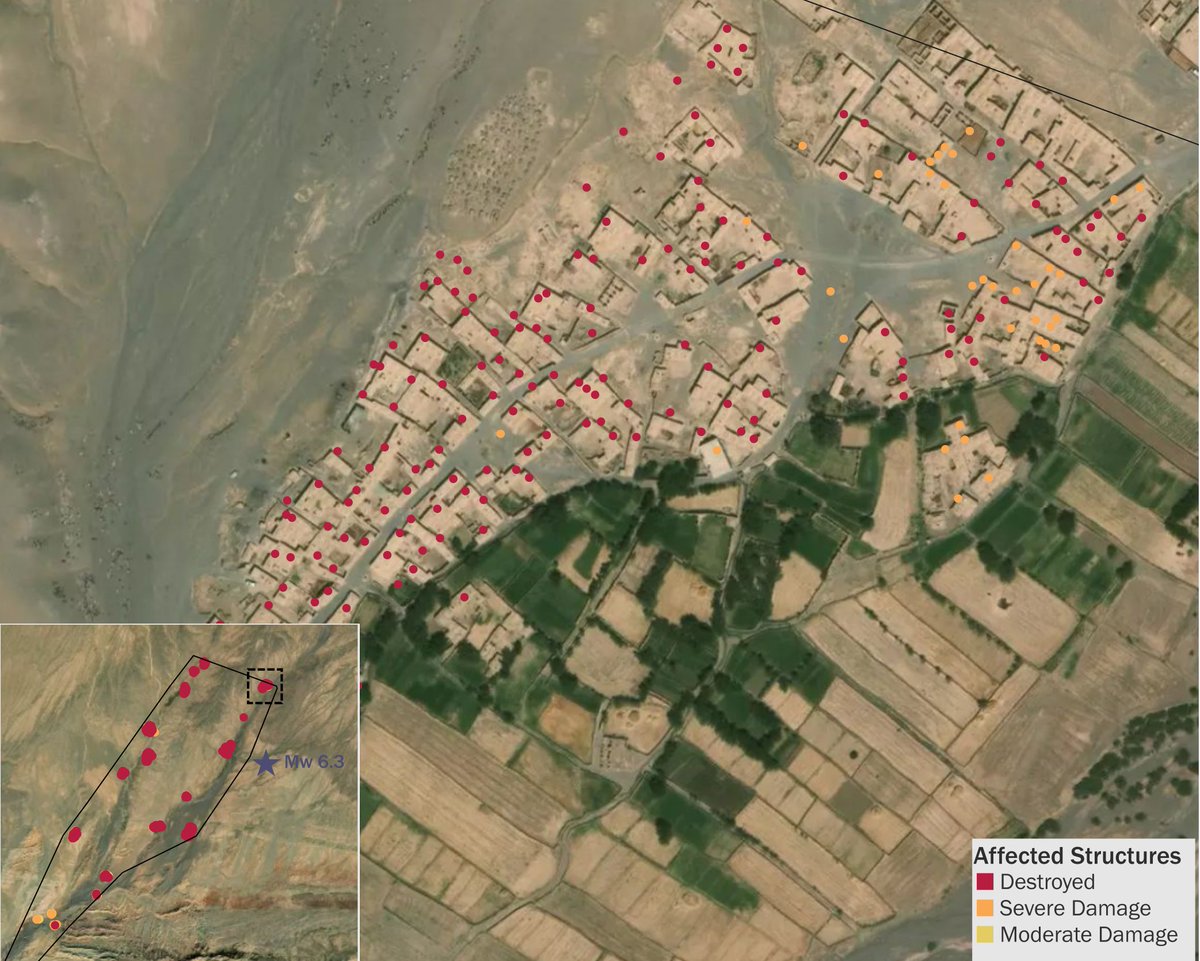
Earthquake hits Herat, Afghanistan on 15 Oct. Below image shows buildings damaged in the Zinda Jan District. #heratearthquake #unosat

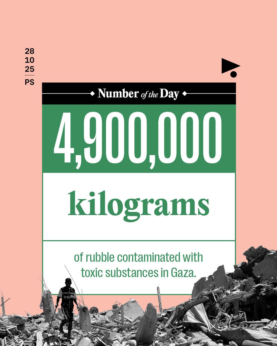
The United Nations Satellite Center (#UNOSAT) revealed that the genocidal war on #Gaza produced approximately 61.5 million tons of rubble, including 4.9 million kilograms of contaminated material. Asbestos poses the greatest health risk as it causes various forms of cancer. It…
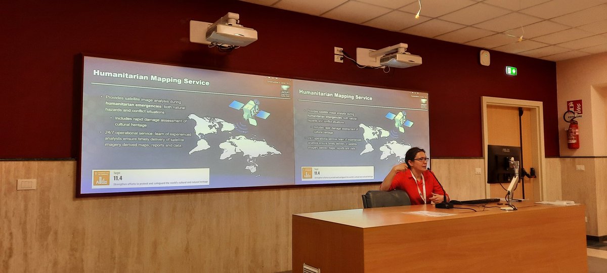
ESA’s Living Planet Symposium, gathering global experts in satellite EO for climate resilience and sustainability. Tomorrow our director Evariste Karambizi will be sharing how #UNOSAT leverages Satellite Data to Support the International Humanitarian Community. Stay tuned! #LPS25


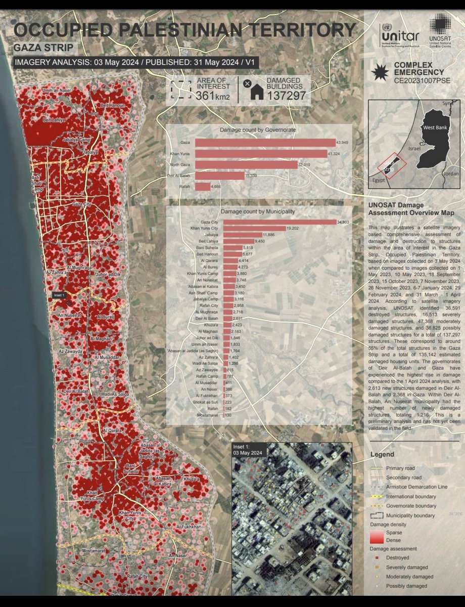
🚨 This map shows a comprehensive satellite imagery-based assessment of damage and destruction in Gaza, Occupied Palestinian Territory, as of 3 May 2024. #UNOSAT #Gaza Not a genocide? 36 kg of explosives for every Palestinian! Over 75.000 tons supplied by the #USA

@UNOSAT detected floods in Koshi & Madhesh Provinces, Nepal (27 Sept 2024) via Sentinel-1 imagery. Approx. 50 km² of land is affected, with 19,000 people exposed. Note: Preliminary data🌍 🚨 Stay tuned! unosat.org/products/3983 #Nepal #Floods #UNOSAT


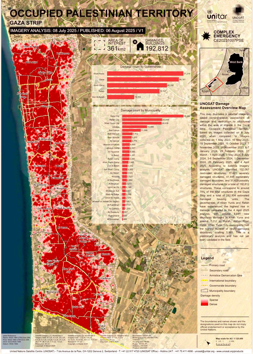
🇵🇸🎞️#Gaza : A Land Turned to Rubble Damage Assessment Report – Gaza Strip (#UNOSAT) This map provides a comprehensive analysis of the destruction of infrastructure and buildings in the Gaza Strip, based on satellite imagery assessed by the United Nations UNOSAT unit. The…

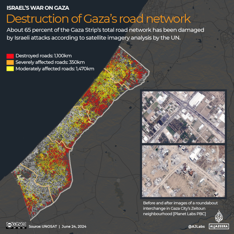
UNOSAT reports that 65% of Gaza's roads have been damaged. Satellite imagery shows 1,100km destroyed, 350km severely affected, and 1,470km moderately affected. #Gaza #RoadDamage #UNOSAT
When #Myanmar earthquakes struck in March 2025, #UNOSAT served as @UNOCHA's 'eyes from above' in hard-to-reach areas. Result: +28,000 buildings assessed, aid prioritised for 6.3M people. 20 years of trusted partnership delivers. 📖Read the Impact story: bit.ly/4klLqzd


God is One. The picture is dedicated to three Abrahamic religions from one God and calls for peace between all. Art with unique technique never use before in the world. #unesco #unosat
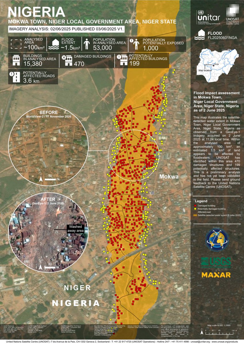
🌊 #Floods in Mokwa, Niger State. Extensive flash flooding reveals severe impacts across the area: - at least 470 houses may have been severely damaged More here 👉 unosat.org/products/4138 #NigeriaFloods #UNOSAT #EmergencyMapping
Hope finished her traineeship with our heritage team from #LPS25. While at #UNOSAT, she monitored biosphere reserves in #Ukraine, conducted damage assessments, and developed a change detection algorithm tool that has already been used in Yemen and Argentina.

🌍From imagery to impact. Behavioural science ensures satellite data leads to action. At #UNOSAT, we bring both together — helping governments and UN agencies prepare, respond, and recover from crisis. 🔗learn more: unitar.org/about/news-sto…

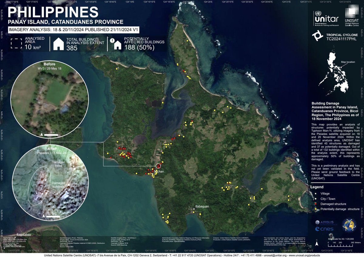
🇵🇭 Impact Update: Panay Island, Catanduanes, Philippines (18-20 Nov 2024) — Satellite analysis reveals 45 damaged and 37 potentially damaged structures (50% of total buildings) due to Typhoon Man-Yi. 📸unosat.org/products/4037 #Philippines #DisasterUpdate #UNOSAT #EMS

Digital forensics has become the backbone of modern heritage protection. When verified through lawful procedures, pixels become proof and proof is the first step toward accountability and restoration. #DigitalHeritage #SatelliteForensics #UNOSAT #ICC #UNESCO #Accountability
#UNOSAT led Session 12 of the ESCAP–SIAP & @UN_Women Training on Big Data & Data Science for Gender Statistics in Asia and the Pacific, showing how satellite data helps reveal gender-based exposure to disasters.
The United Nations Satellite Center (#UNOSAT) revealed that the genocidal war on #Gaza produced approximately 61.5 million tons of rubble, including 4.9 million kilograms of contaminated material. Asbestos poses the greatest health risk as it causes various forms of cancer. It…
#UNOSAT joined the Consultative Workshop on ''Climate Displacement'' by #NISA Cambodia & SPP Chiang Mai University, sharing insights on using geospatial tech to map displacement risk and a case study from #Thailand. #SPPCMU #climatedisplacement
🇵🇸🎞️#Gaza : A Land Turned to Rubble Damage Assessment Report – Gaza Strip (#UNOSAT) This map provides a comprehensive analysis of the destruction of infrastructure and buildings in the Gaza Strip, based on satellite imagery assessed by the United Nations UNOSAT unit. The…
We’re excited and proud to launch our new #GeoAI Training on Land Monitoring in #Bhutan 🇧🇹, co-organized with our long-term partner @nlcsbhutan — empowering national experts with advanced tools such as deep learning and super-resolution. #UNOSAT #RemoteSensing #Training
Hope finished her traineeship with our heritage team from #LPS25. While at #UNOSAT, she monitored biosphere reserves in #Ukraine, conducted damage assessments, and developed a change detection algorithm tool that has already been used in Yemen and Argentina.
When #Myanmar earthquakes struck in March 2025, #UNOSAT served as @UNOCHA's 'eyes from above' in hard-to-reach areas. Result: +28,000 buildings assessed, aid prioritised for 6.3M people. 20 years of trusted partnership delivers. 📖Read the Impact story: bit.ly/4klLqzd
ESA’s Living Planet Symposium, gathering global experts in satellite EO for climate resilience and sustainability. Tomorrow our director Evariste Karambizi will be sharing how #UNOSAT leverages Satellite Data to Support the International Humanitarian Community. Stay tuned! #LPS25
🌍From imagery to impact. Behavioural science ensures satellite data leads to action. At #UNOSAT, we bring both together — helping governments and UN agencies prepare, respond, and recover from crisis. 🔗learn more: unitar.org/about/news-sto…
🤝Today we had the pleasure to welcome @JAXA_en at UNOSAT. A valuable exchange on how satellite technology can support disaster response, sustainable development, and global resilience. #UNOSAT #JAXA #SpaceForDevelopment #Geospatial


🌊 #Floods in Mokwa, Niger State. Extensive flash flooding reveals severe impacts across the area: - at least 470 houses may have been severely damaged More here 👉 unosat.org/products/4138 #NigeriaFloods #UNOSAT #EmergencyMapping

Una evaluación geoespacial realizada por la #FAO y el Centro de Satélites de las Naciones Unidas #Unosat reveló que menos del 5 por ciento de la superficie cultivable de la Franja de Gaza permanece accesible o cultivable telesurtv.net/fao-denuncia-d…
telesurtv.net
FAO denuncia destrucción masiva de la agricultura en Gaza por Israel - teleSUR
Casi ninguna tierra de cultivo se halla accesible. Los bombardeos de Israel impiden producir alimentos y exacerban la hambruna.
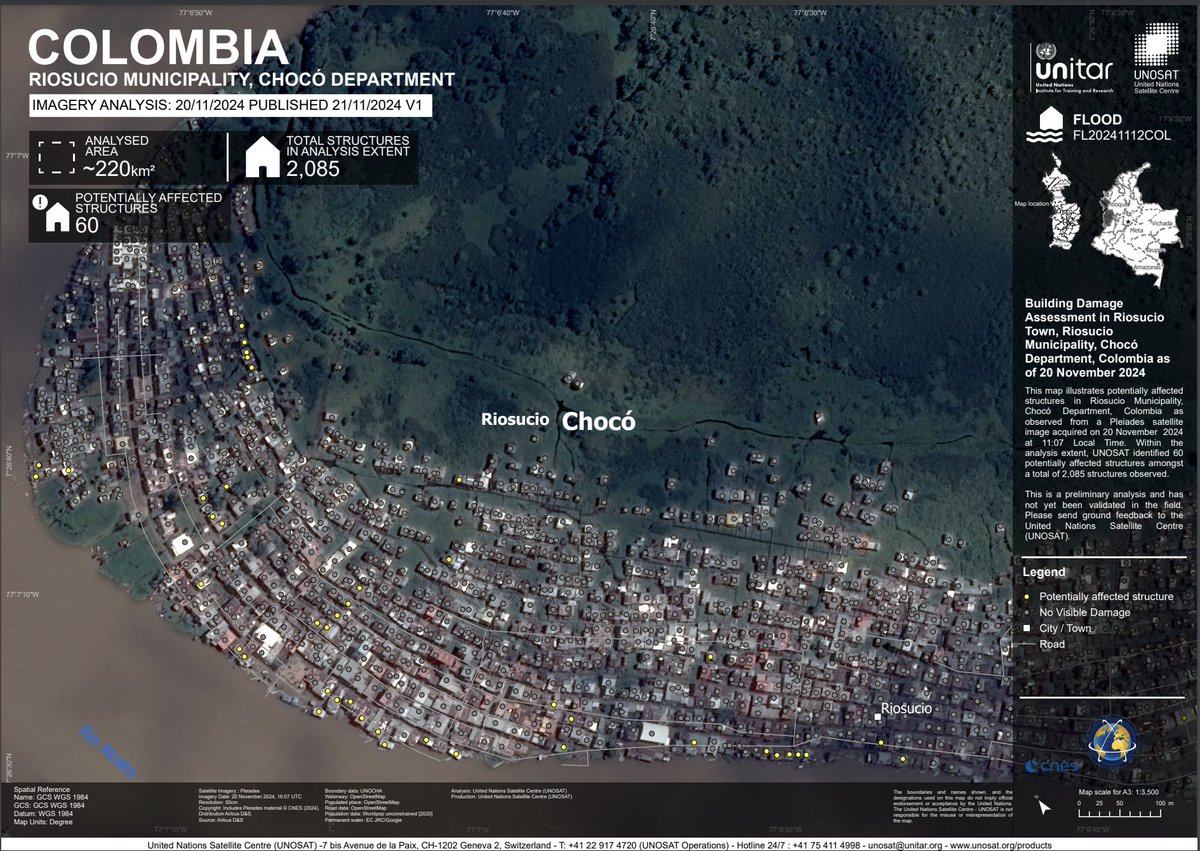
🇨🇴 Damage Update: Chocó, Colombia (17 & 20 Nov 2024) — Bellavista: 13 affected, 3 potentially affected (out of 2,165). Riosucio: 60 potentially affected (out of 2,085). 📸unosat.org/products/4033 #Colombia #DisasterUpdate #UNOSAT #EMS
🇵🇭 Impact Update: Panay Island, Catanduanes, Philippines (18-20 Nov 2024) — Satellite analysis reveals 45 damaged and 37 potentially damaged structures (50% of total buildings) due to Typhoon Man-Yi. 📸unosat.org/products/4037 #Philippines #DisasterUpdate #UNOSAT #EMS
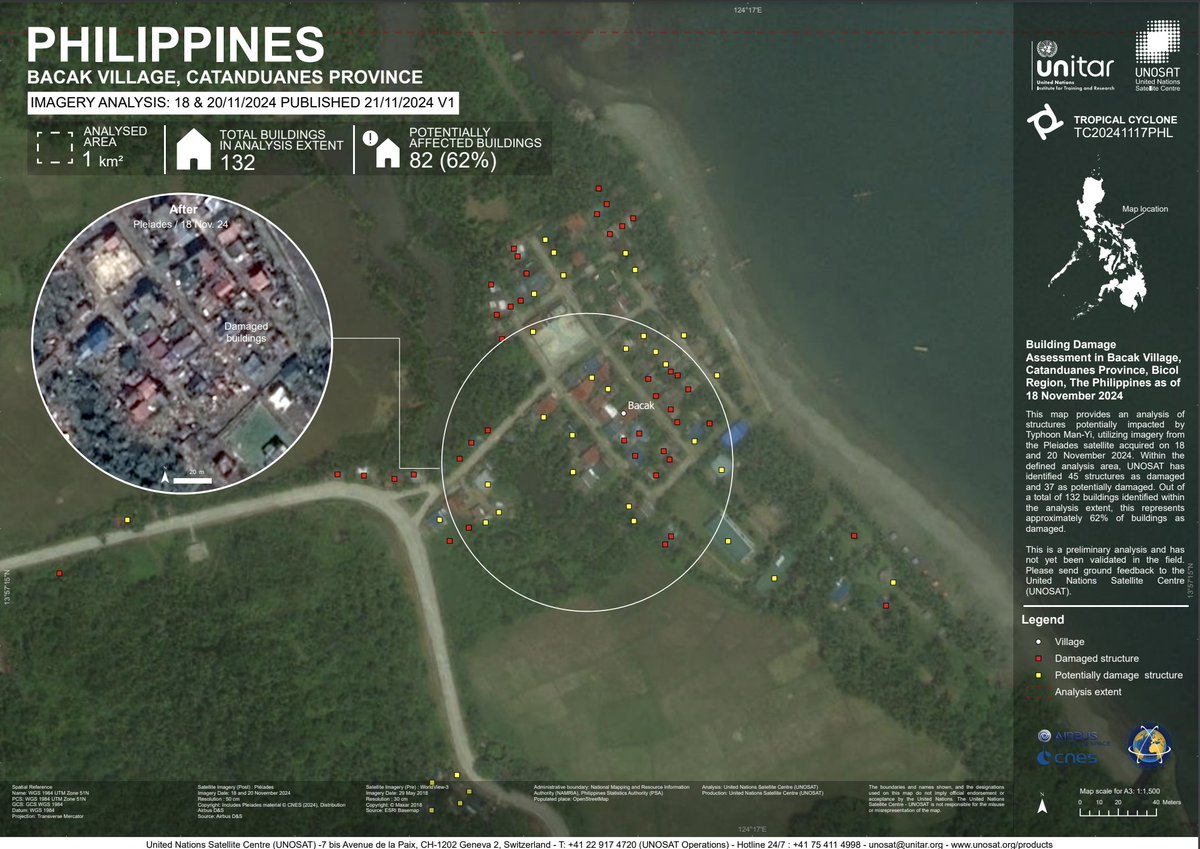
🇵🇭 Impact Update: Bacak Village, Catanduanes, Philippines (18-20 Nov 2024) — Satellite analysis reveals 45 damaged and 37 potentially damaged structures (62% of total buildings) due to Typhoon Man-Yi. 📸unosat.org/products/4036 #Philippines #DisasterUpdate #UNOSAT #EMS


#UNOSAT joined the Consultative Workshop on ''Climate Displacement'' by #NISA Cambodia & SPP Chiang Mai University, sharing insights on using geospatial tech to map displacement risk and a case study from #Thailand. #SPPCMU #climatedisplacement
We’re excited and proud to launch our new #GeoAI Training on Land Monitoring in #Bhutan 🇧🇹, co-organized with our long-term partner @nlcsbhutan — empowering national experts with advanced tools such as deep learning and super-resolution. #UNOSAT #RemoteSensing #Training
Our session 745 (Remote Sensing) of #EAA kicking off with a presentation from Dr Michelle De Gruchy from #UNOSAT
The United Nations Satellite Center (#UNOSAT) revealed that the genocidal war on #Gaza produced approximately 61.5 million tons of rubble, including 4.9 million kilograms of contaminated material. Asbestos poses the greatest health risk as it causes various forms of cancer. It…
#UNOSAT led Session 12 of the ESCAP–SIAP & @UN_Women Training on Big Data & Data Science for Gender Statistics in Asia and the Pacific, showing how satellite data helps reveal gender-based exposure to disasters.
ESA’s Living Planet Symposium, gathering global experts in satellite EO for climate resilience and sustainability. Tomorrow our director Evariste Karambizi will be sharing how #UNOSAT leverages Satellite Data to Support the International Humanitarian Community. Stay tuned! #LPS25
Earthquake hits Herat, Afghanistan on 15 Oct. Below image shows buildings damaged in the Zinda Jan District. #heratearthquake #unosat
During APSCO’s Disaster Response Workshop, we presented our Emergency Mapping Service and shared how geospatial analysis supports humanitarian response through Flood AI and the 2025 Myanmar earthquake case. #UNOSAT #APSCO #FloodAI #DisasterResponse #Geospatial @
When #Myanmar earthquakes struck in March 2025, #UNOSAT served as @UNOCHA's 'eyes from above' in hard-to-reach areas. Result: +28,000 buildings assessed, aid prioritised for 6.3M people. 20 years of trusted partnership delivers. 📖Read the Impact story: bit.ly/4klLqzd
🌊 #Floods in Mokwa, Niger State. Extensive flash flooding reveals severe impacts across the area: - at least 470 houses may have been severely damaged More here 👉 unosat.org/products/4138 #NigeriaFloods #UNOSAT #EmergencyMapping
UNOSAT reports that 65% of Gaza's roads have been damaged. Satellite imagery shows 1,100km destroyed, 350km severely affected, and 1,470km moderately affected. #Gaza #RoadDamage #UNOSAT

Space Café Radio - from GLOC in Oslo - with Dr Einar Bjørgo @iafastro @timmermansr #GLOC2023 @Romsenteret #UNOSAT spacewatch.global/2023/07/space-…

Hope finished her traineeship with our heritage team from #LPS25. While at #UNOSAT, she monitored biosphere reserves in #Ukraine, conducted damage assessments, and developed a change detection algorithm tool that has already been used in Yemen and Argentina.
🚀 Dr. Einar Bjørgo dives into UNOSAT's pivotal work at #6! #UNOSAT #SpaceCafeAudio #SpaceCafeRadio #SpaceCafePodcast @mmooslechner @NirmaSuper @thatspacegirl___ @FaletiJoshua @TKriening #einarbjørgo spacewatch.global/2023/07/space-…

🚨 This map shows a comprehensive satellite imagery-based assessment of damage and destruction in Gaza, Occupied Palestinian Territory, as of 3 May 2024. #UNOSAT #Gaza Not a genocide? 36 kg of explosives for every Palestinian! Over 75.000 tons supplied by the #USA
🤝Today we had the pleasure to welcome @JAXA_en at UNOSAT. A valuable exchange on how satellite technology can support disaster response, sustainable development, and global resilience. #UNOSAT #JAXA #SpaceForDevelopment #Geospatial
@UNOSAT detected floods in Koshi & Madhesh Provinces, Nepal (27 Sept 2024) via Sentinel-1 imagery. Approx. 50 km² of land is affected, with 19,000 people exposed. Note: Preliminary data🌍 🚨 Stay tuned! unosat.org/products/3983 #Nepal #Floods #UNOSAT
🇵🇭 Impact Update: Panay Island, Catanduanes, Philippines (18-20 Nov 2024) — Satellite analysis reveals 45 damaged and 37 potentially damaged structures (50% of total buildings) due to Typhoon Man-Yi. 📸unosat.org/products/4037 #Philippines #DisasterUpdate #UNOSAT #EMS
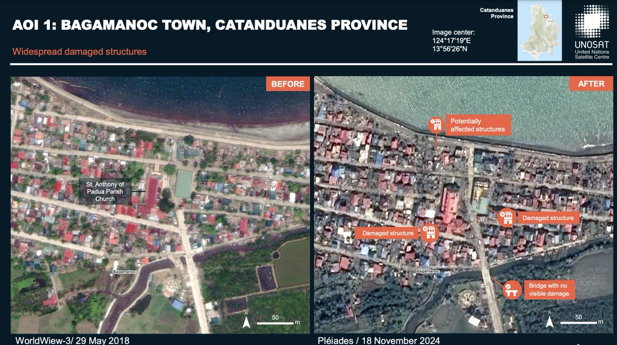
🇵🇭 Impact Update: Catanduanes, Philippines (19 Nov 2024) — Satellite analysis reveals widespread structural damage in the province. No flooding observed; Virac Airport and Port remain undamaged. 📸unosat.org/products/4027 #Philippines #DisasterUpdate #UNOSAT #EMS
Something went wrong.
Something went wrong.
United States Trends
- 1. Peggy 31.4K posts
- 2. Sonic 06 2,203 posts
- 3. Berseria 4,513 posts
- 4. Zeraora 13.5K posts
- 5. Cory Mills 27.7K posts
- 6. #ComunaONada 3,155 posts
- 7. $NVDA 45.4K posts
- 8. Randy Jones N/A
- 9. Dearborn 370K posts
- 10. Luxray 2,277 posts
- 11. Ryan Wedding 3,499 posts
- 12. Xillia 2 N/A
- 13. Encyclopedia Galactica 5,250 posts
- 14. #CurrysPurpleFriday 12.3K posts
- 15. #wednesdaymotivation 8,031 posts
- 16. #Wednesdayvibe 2,917 posts
- 17. International Men's Day 80.4K posts
- 18. Cleo 3,180 posts
- 19. Rick Hendrick N/A
- 20. Cooks 9,924 posts