#wiwx search results

[4/22/26] 3 PM ⛈️Expect highs to peak in the upper 70s to low 80s tomorrow, with temps around 20 degrees cooler along the lakeshore. Scattered rain and storms then arrive Thursday evening, continuing through Friday afternoon. A stronger storm or two cannot be ruled out. #wiwx
![NWSGreenBay's tweet image. [4/22/26] 3 PM
⛈️Expect highs to peak in the upper 70s to low 80s tomorrow, with temps around 20 degrees cooler along the lakeshore. Scattered rain and storms then arrive Thursday evening, continuing through Friday afternoon. A stronger storm or two cannot be ruled out.
#wiwx](https://pbs.twimg.com/media/HGiAFpmWAAAd8ex.jpg)


Wisconsin is the new tornado alley (atleast so far in 2026) prove me wrong. 🤷♂️ #wiwx

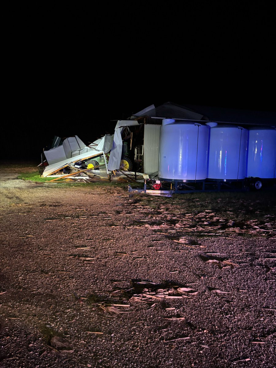
#UPDATE: Aerial drone footage reveals the devastating aftermath after a tornado tore through a neighborhood in Ringle, WI Friday. Preliminary reports estimate the tornado reached EF-3 strength, with winds ranging between 140- 145 mph.#WIwx

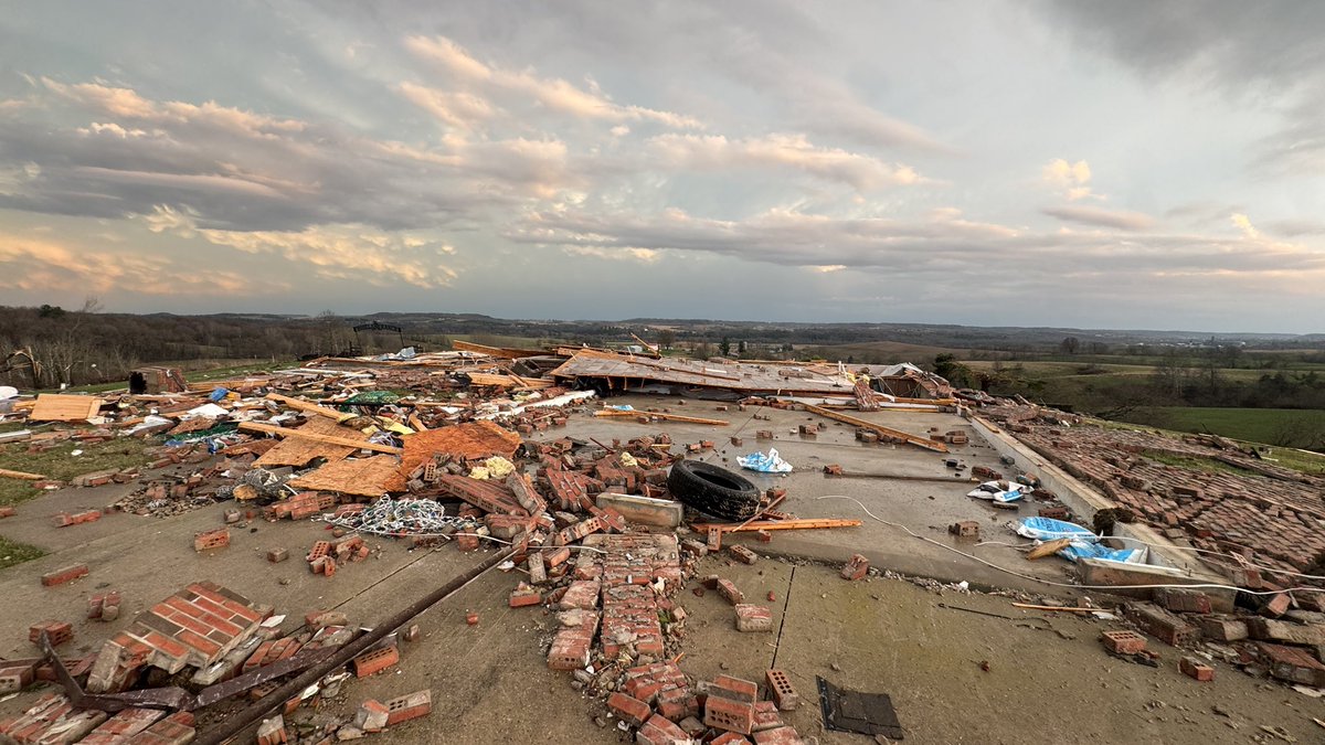
My photo of the home leveled west of Union Center, WI #wiwx

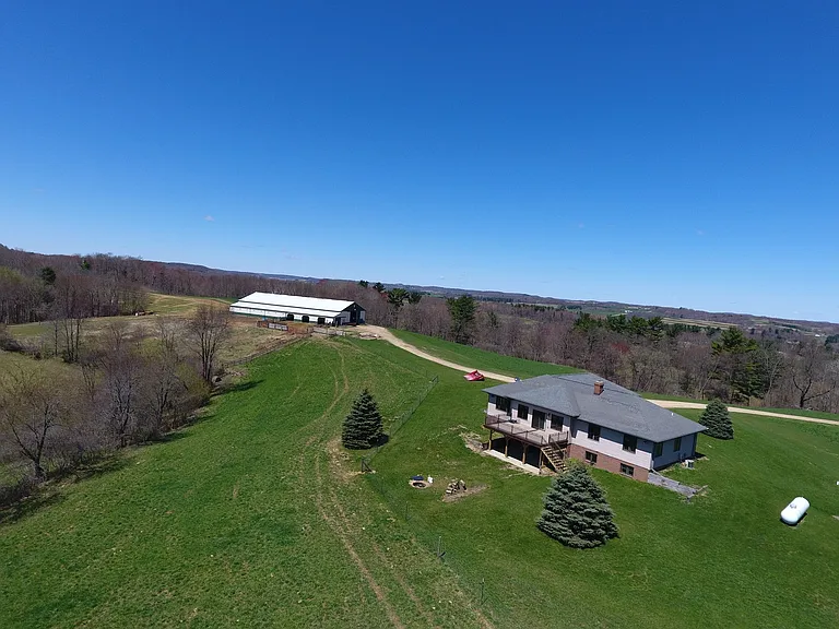
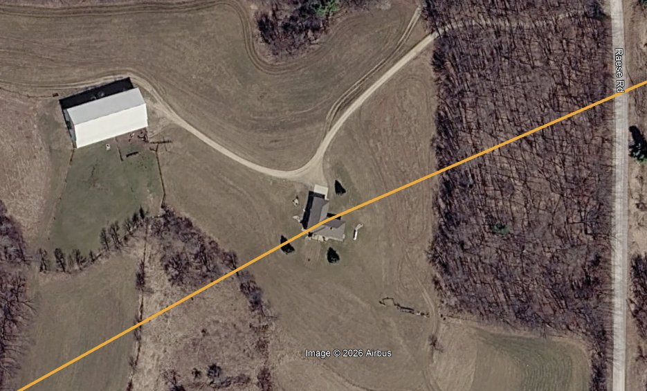
Egan shared a few photos with me from the Union Center, Wisconsin tornado earlier today. I will not share them here, but here are some observations I made. Information on this home: N1503 Raese Rd, Elroy, WI - Single-story residence with a walkout basement (effectively two


I think the 2% tor risk from the SPC, is a good call for tomorrow across MN and WI. Enough spin below 1km, plus a low LCL I think if storm interactions can stay minimal, a tornado wouldn't surprise me. #mnwx #wiwx.

Some folks driving around with busted windows and huge car dents north/northeast of Madison, WI #wiwx


Some more footage of the Rockton/Harrison, IL tornado from earlier. Arguably some of my best shots yet. Was surprisingly photogenic, under a sculpted, structured supercell. Ya really can’t beat it! #ilwx #wiwx #tornado

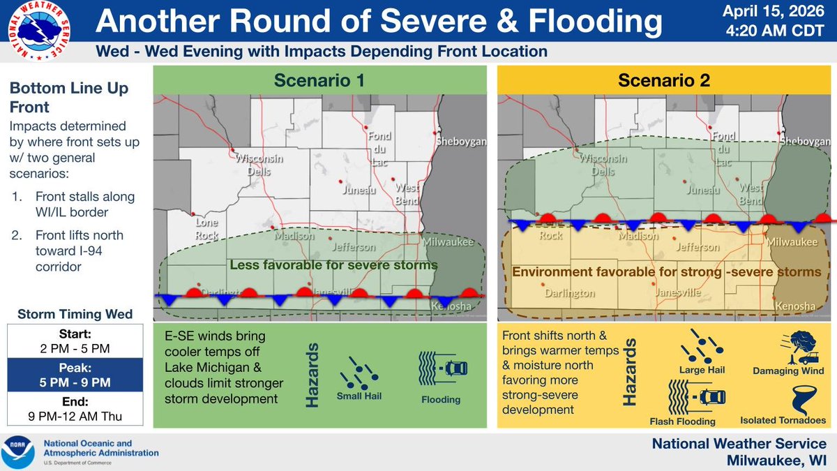
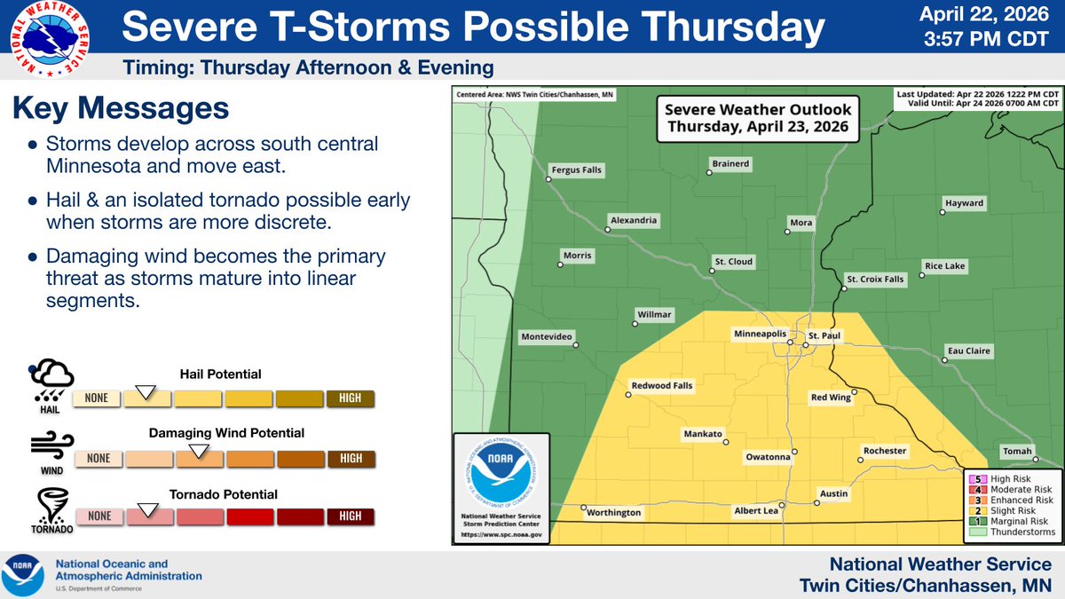
Another day, another severe weather risk, though not as high end as Tuesday. The extent of the risk depends boundary placement. The further north the boundary moves, prepare for locally damaging wind gusts, hail to the size of quarters and perhaps a tornado. #wiwx
"BASEBALL SIZED BOMBS" 🔊🔊 One Madison, WI resident talks us through the large hail that pelted his home early Tuesday evening. Just listen to the hailstones pound the roof. #WIwx
Drone footage of bridge that completely washed out in Janesville, Wis due to Fridays heavy rains and floods. #wiwx #flood


Significant flooding across parts of Milwaukee. This video was captured by PJ outside BelAir Cantina on Water Street. #MKEwx #WIwx
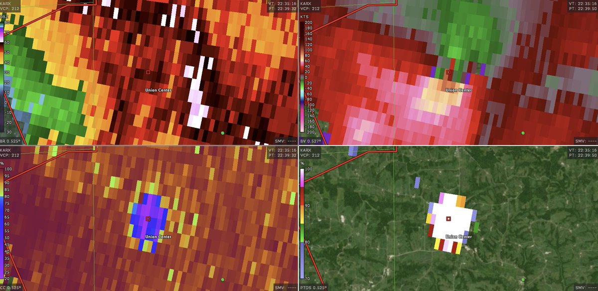
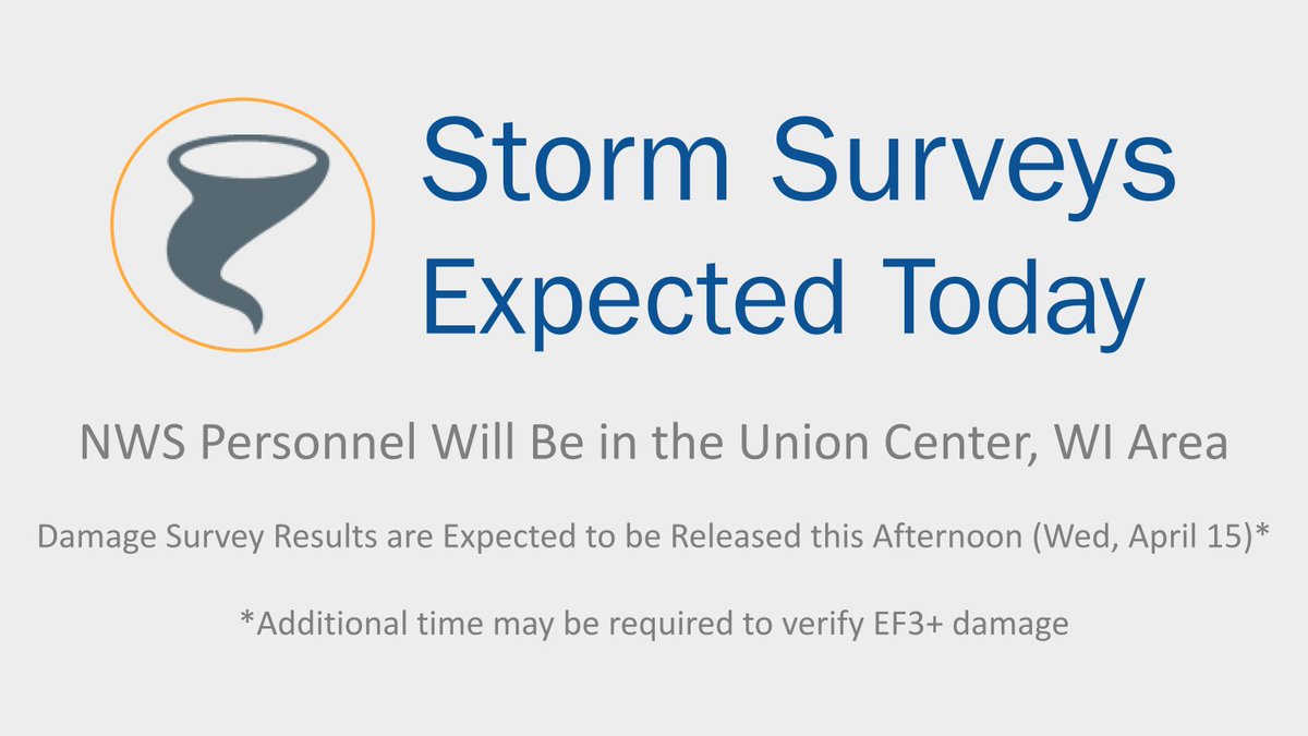
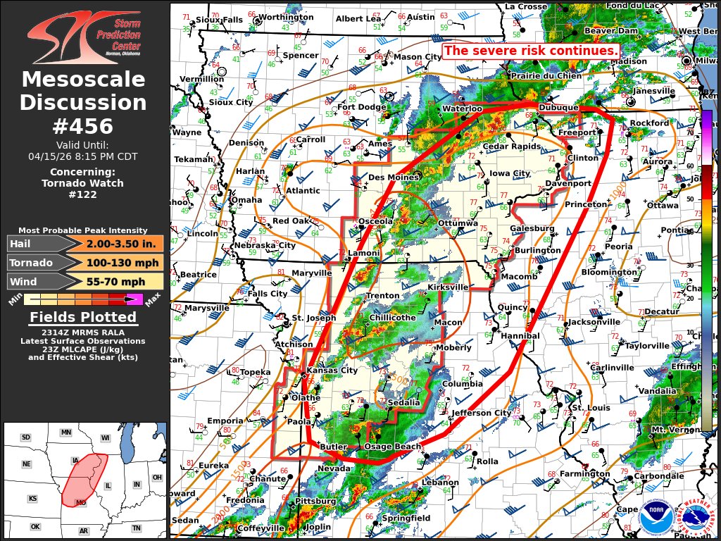
The NWS will be surveying the tornado track that occurred in the Union Center, WI area later today (Wed, April 15). Results of this survey will be released later this afternoon. Please note that any determination of an EF3+ rating may take additional time. #wiwx
Video showing street flooding in Green Bay at the corner of S Oneida and W Mason streets. There are reports of similar areas throughout Green Bay. Remain vigilant and DO NOT drive through flooded roads. #TurnAroundDontDrown View flood warnings at: water.noaa.gov/wfo/grb #wiwx

Drone footage of bridge that completely washed out in Janesville, Wis due to Fridays heavy rains and floods. #wiwx #flood
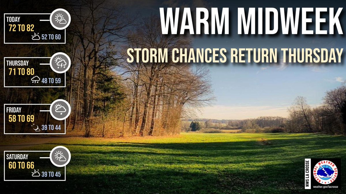
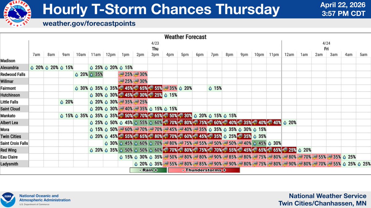
Showers and storms move into the region Thursday evening and overnight with a few storms potentially becoming severe. Damaging wind gusts and hail up to quarter sized will be the main hazards with any severe storms. Be sure to seek shelter as storms approach! #mnwx #iawx #wiwx


STANDING-BY FOR NEWS, WEATHER & HBAVO: #WIWX #HBAVO #HBAVOSTUDY #WXUNIT #NEWSUNIT x.com/i/broadcasts/1…

A cold front will move through on Thursday. This will bring another round of scattered storms Thursday afternoon & evening. Some of these storms could become strong to severe, with damaging winds & large hail the primary threat. Cooler temps return for the weekend. #mnwx #wiwx


[4/22/26] 4:00 PM CONCERNING TOMORROW (APR 23RD) The whole badger state has been placed under a marginal risk (level 1 of 5) for severe weather. Given earlier timing of the storms, there’s a brief window for strong to severe damaging winds. Heavy rain is the main threat. #wiwx
![NESEWisconsinWX's tweet image. [4/22/26] 4:00 PM
CONCERNING TOMORROW (APR 23RD)
The whole badger state has been placed under a marginal risk (level 1 of 5) for severe weather. Given earlier timing of the storms, there’s a brief window for strong to severe damaging winds. Heavy rain is the main threat. #wiwx](https://pbs.twimg.com/media/HGidtumXkAAEBI0.jpg)

A re-entry plan for the flooded downtown area of New London was implemented today. FOX 11's Tony Langfellow has this report from the city as floodwaters continued to recede. More details: fox11online.com/news/local/new… #wiwx @natwxdesk
[4/22/26] 3 PM ⛈️Expect highs to peak in the upper 70s to low 80s tomorrow, with temps around 20 degrees cooler along the lakeshore. Scattered rain and storms then arrive Thursday evening, continuing through Friday afternoon. A stronger storm or two cannot be ruled out. #wiwx
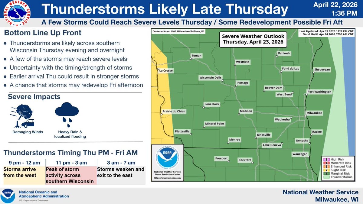
Thunderstorms are likely across southern Wisconsin Thursday evening and overnight. A few of the storms may reach severe levels, with damaging winds and locally heavy rainfall the main threats. There is a chance that storms may redevelop Friday afternoon. #wiwx
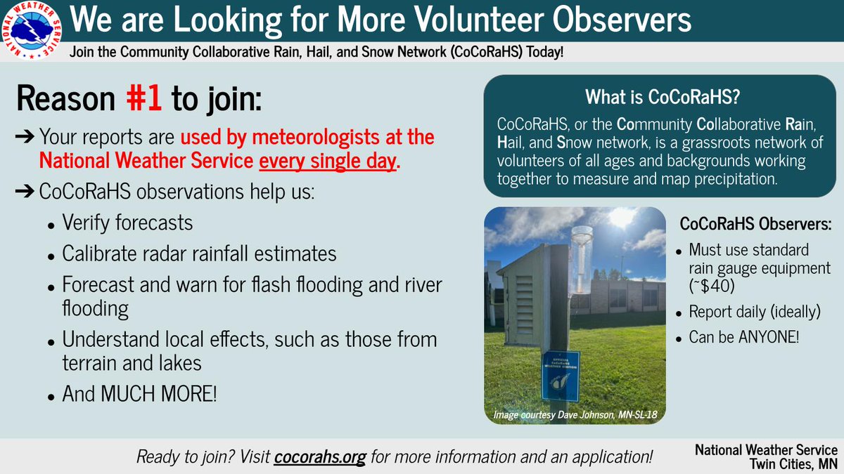
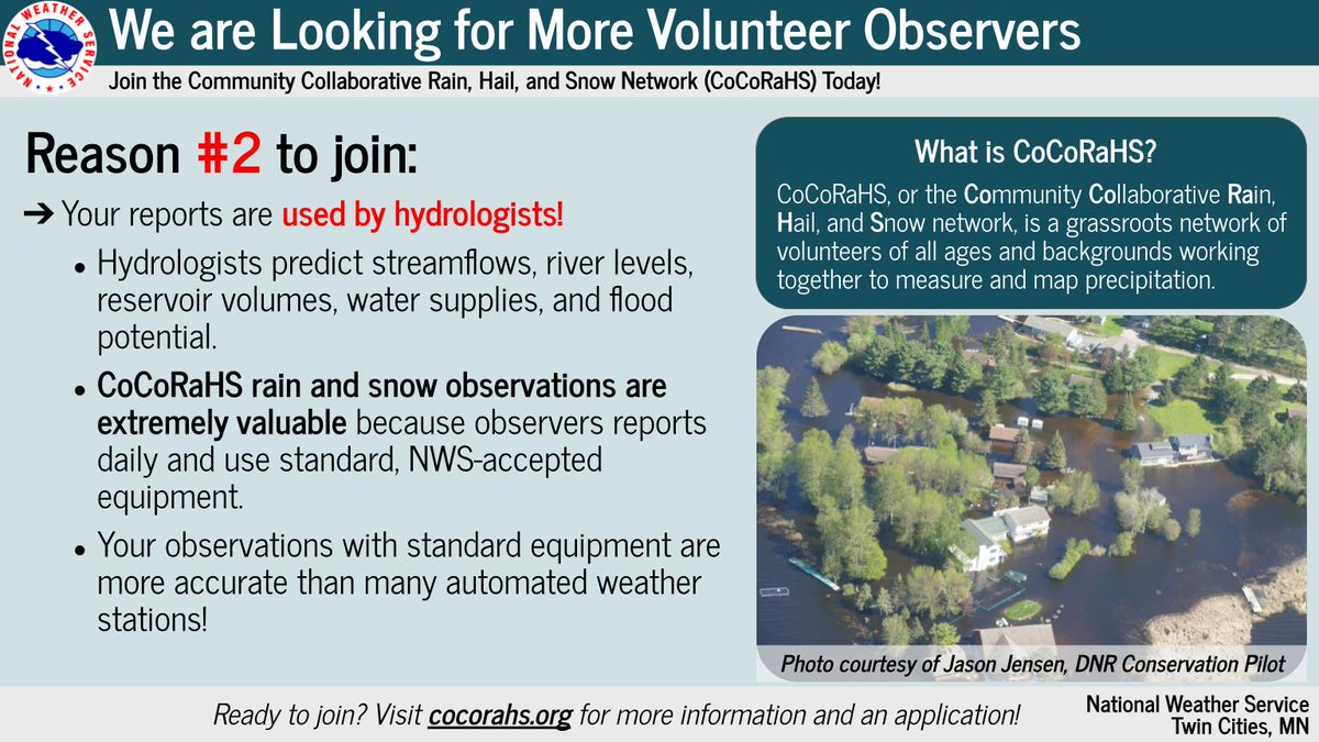
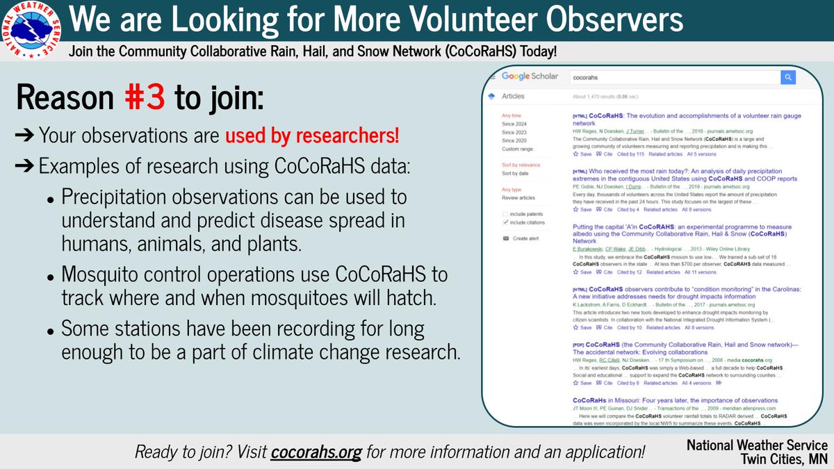
We are actively recruiting new observers for the Community Collaborative Rain, Hail, and Snow Network (CoCoRaHS). Need that extra push to join? Check out these four reasons why you should! If you're interested in joining, go to cocorahs.org today! #MNwx #WIwx


[12:20 PM Wednesday]- Relative humidity has dropped to around 30% or lower across most of north central Wisconsin. This will result in elevated fire danger. Thursday will also feature low humidity. #wiwx #wsawwx #FirstAlertWeather MORE INFO: wsaw.com/weather/
![WxSpencerFurman's tweet image. [12:20 PM Wednesday]- Relative humidity has dropped to around 30% or lower across most of north central Wisconsin. This will result in elevated fire danger. Thursday will also feature low humidity.
#wiwx #wsawwx #FirstAlertWeather
MORE INFO: wsaw.com/weather/](https://pbs.twimg.com/media/HGhqbDbWkAEuf4s.jpg)
![WxSpencerFurman's tweet image. [12:20 PM Wednesday]- Relative humidity has dropped to around 30% or lower across most of north central Wisconsin. This will result in elevated fire danger. Thursday will also feature low humidity.
#wiwx #wsawwx #FirstAlertWeather
MORE INFO: wsaw.com/weather/](https://pbs.twimg.com/media/HGhqbDnXkAIHvs8.jpg)
![WxSpencerFurman's tweet image. [12:20 PM Wednesday]- Relative humidity has dropped to around 30% or lower across most of north central Wisconsin. This will result in elevated fire danger. Thursday will also feature low humidity.
#wiwx #wsawwx #FirstAlertWeather
MORE INFO: wsaw.com/weather/](https://pbs.twimg.com/media/HGhqbDaW8AA9jVY.jpg)
![WxSpencerFurman's tweet image. [12:20 PM Wednesday]- Relative humidity has dropped to around 30% or lower across most of north central Wisconsin. This will result in elevated fire danger. Thursday will also feature low humidity.
#wiwx #wsawwx #FirstAlertWeather
MORE INFO: wsaw.com/weather/](https://pbs.twimg.com/media/HGhqbDuXUAAZL5A.jpg)
I think the 2% tor risk from the SPC, is a good call for tomorrow across MN and WI. Enough spin below 1km, plus a low LCL I think if storm interactions can stay minimal, a tornado wouldn't surprise me. #mnwx #wiwx.

In the unincorporated community of #Tichigan, homeowners are racing to protect their properties from overflow of the #FoxRiver, stacking sandbags and running pumps. #wiwx #flooding
Residents who evacuated from the flooded village of Shiocton will be able to return to their homes in a few days. Get the full story: fox11online.com/weather/weathe… #wiwx @natwxdesk

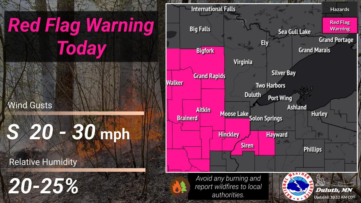
Fire weather conditions are critical today over portions of NE MN and NW WI. Wind gusts from the south at 20–30 mph paired with relative humidity as low as 20–25%. These factors mean that any fire that starts can spread rapidly. #MNwx #WIwx
New short up on my YouTube about the April 14, 2026 storm chase, which features my chase experience of the Union Center, WI EF3: youtube.com/shorts/fcTRD3C… Full chase video coming soon. #wiwx

youtube.com
YouTube
Young Weather
Enjoy time outdoors today and tomorrow, because storms return to the state Thursday evening into the overnight. A few storms may be on the strong side, mainly capable of producing heavy rainfall and gusty conditions. #WIwx


WILDFIRE DANGER: The Wisconsin DNR has upped the entire state to either a high or very high fire danger for today. Burning is highly discouraged today. Some areas may see their burn permits suspended today as a result of the risk. Please avoid burning debris today. #wiwx

[8:11 AM Wednesday]- Severe weather is still unlikely Thursday night into Friday morning, but a couple of storms do have the potential to become strong. There is also concern for heavy rainfall. #wiwx #wsawwx #FirstAlertWeather STORY: wsaw.com/2026/04/22/ano…
![WxSpencerFurman's tweet image. [8:11 AM Wednesday]- Severe weather is still unlikely Thursday night into Friday morning, but a couple of storms do have the potential to become strong.
There is also concern for heavy rainfall.
#wiwx #wsawwx #FirstAlertWeather
STORY: wsaw.com/2026/04/22/ano…](https://pbs.twimg.com/media/HGgx732XYAA5Q8-.jpg)
![WxSpencerFurman's tweet image. [8:11 AM Wednesday]- Severe weather is still unlikely Thursday night into Friday morning, but a couple of storms do have the potential to become strong.
There is also concern for heavy rainfall.
#wiwx #wsawwx #FirstAlertWeather
STORY: wsaw.com/2026/04/22/ano…](https://pbs.twimg.com/media/HGgx734WMAAs4Uh.jpg)
![WxSpencerFurman's tweet image. [8:11 AM Wednesday]- Severe weather is still unlikely Thursday night into Friday morning, but a couple of storms do have the potential to become strong.
There is also concern for heavy rainfall.
#wiwx #wsawwx #FirstAlertWeather
STORY: wsaw.com/2026/04/22/ano…](https://pbs.twimg.com/media/HGgx9DRWwAA2c1U.jpg)
We'll be seeing lots of sunshine throughout your Wednesday with highs temperatures ranging from the upper 50s along the lakefront in eastern #Wisconsin to the low 80s for parts of far western Wisconsin. #WIwx

[6:21 AM Wednesday]- We're on track for another sunny day with highs in the low to mid-70s during the afternoon. #wiwx #wsawwx #FirstAlertWeather MORE INFO: wsaw.com/weather/
![WxSpencerFurman's tweet image. [6:21 AM Wednesday]- We're on track for another sunny day with highs in the low to mid-70s during the afternoon.
#wiwx #wsawwx #FirstAlertWeather
MORE INFO: wsaw.com/weather/](https://pbs.twimg.com/media/HGgYERAWQAA1pcL.jpg)
![WxSpencerFurman's tweet image. [6:21 AM Wednesday]- We're on track for another sunny day with highs in the low to mid-70s during the afternoon.
#wiwx #wsawwx #FirstAlertWeather
MORE INFO: wsaw.com/weather/](https://pbs.twimg.com/media/HGgYEQ8XAAAGowz.jpg)
![WxSpencerFurman's tweet image. [6:21 AM Wednesday]- We're on track for another sunny day with highs in the low to mid-70s during the afternoon.
#wiwx #wsawwx #FirstAlertWeather
MORE INFO: wsaw.com/weather/](https://pbs.twimg.com/media/HGgYF6XXYAAxERp.jpg)


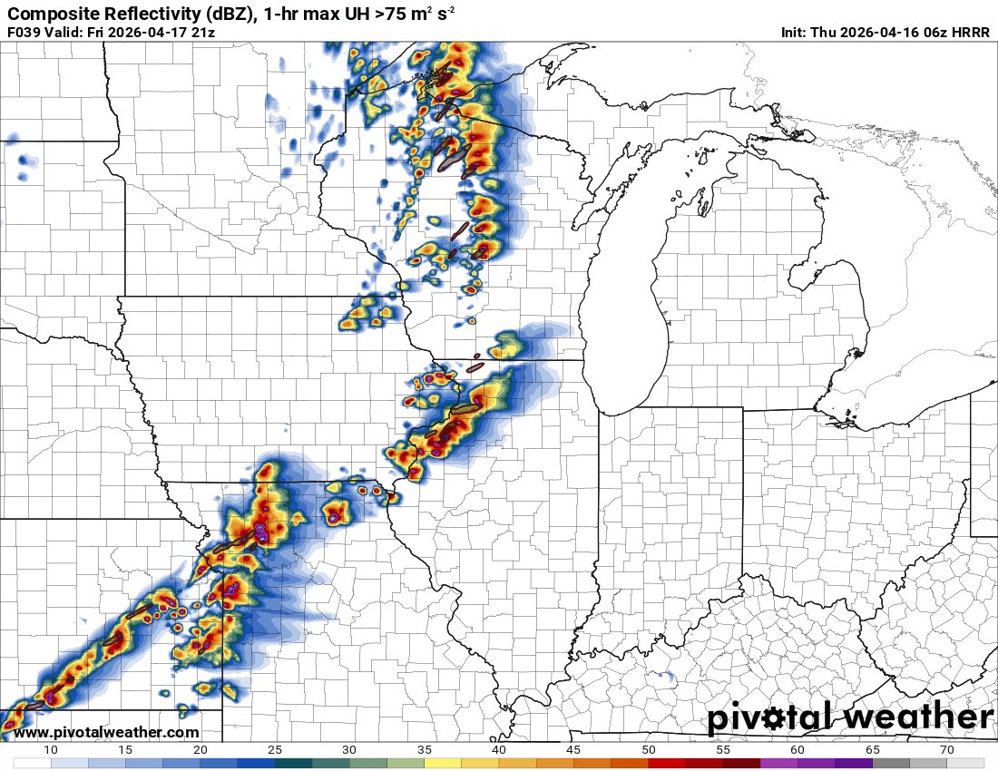
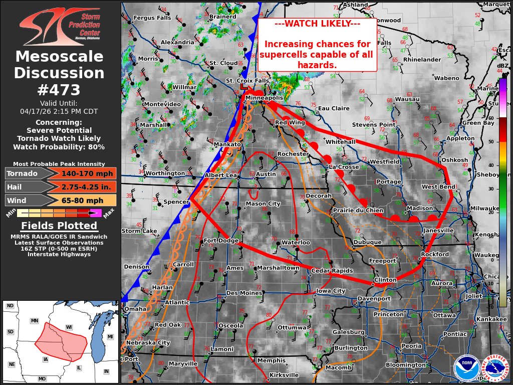
The HRRR will most definitely change, but the 0z hrrr just paints a scary supercell over southern Wisconsin tomorrow evening. 👀 #wiwx

That's a ridiculous run I have ever seen for the state of Wisconsin. However, it is still 30 plus hours out though. A lot can change. #wiwx #wx


Another day, another severe weather risk, though not as high end as Tuesday. The extent of the risk depends boundary placement. The further north the boundary moves, prepare for locally damaging wind gusts, hail to the size of quarters and perhaps a tornado. #wiwx
Thunderstorms are likely across southern Wisconsin Thursday evening and overnight. A few of the storms may reach severe levels, with damaging winds and locally heavy rainfall the main threats. There is a chance that storms may redevelop Friday afternoon. #wiwx

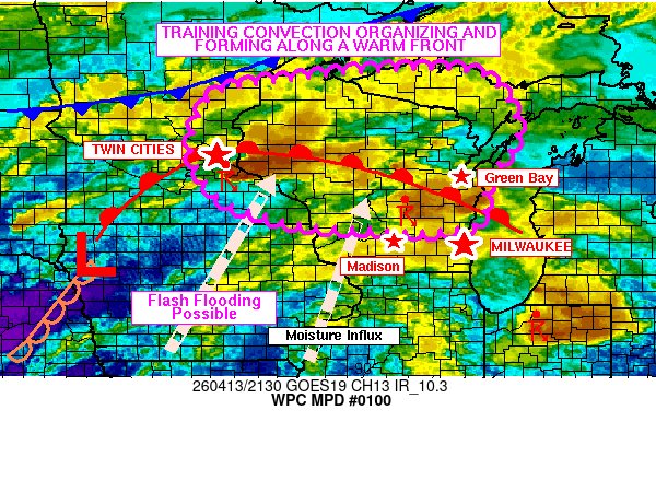
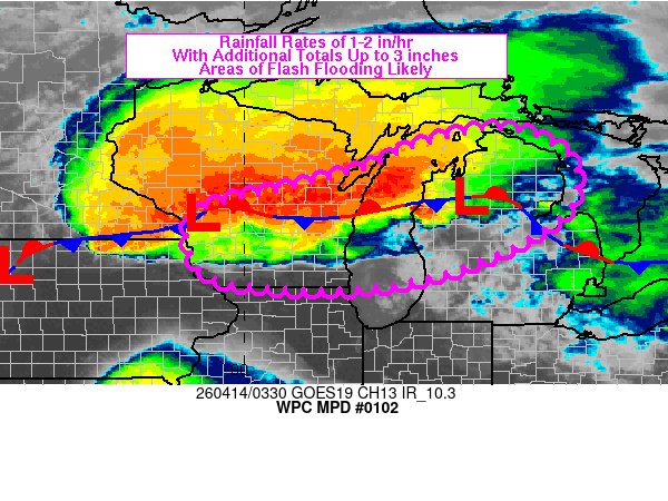
#WPC_MD 0100 affecting Much of Wisconsin, Southeastern Minnesota, and U.P. of Michigan, #miwx #wiwx #iawx #mnwx, wpc.ncep.noaa.gov/metwatch/metwa…
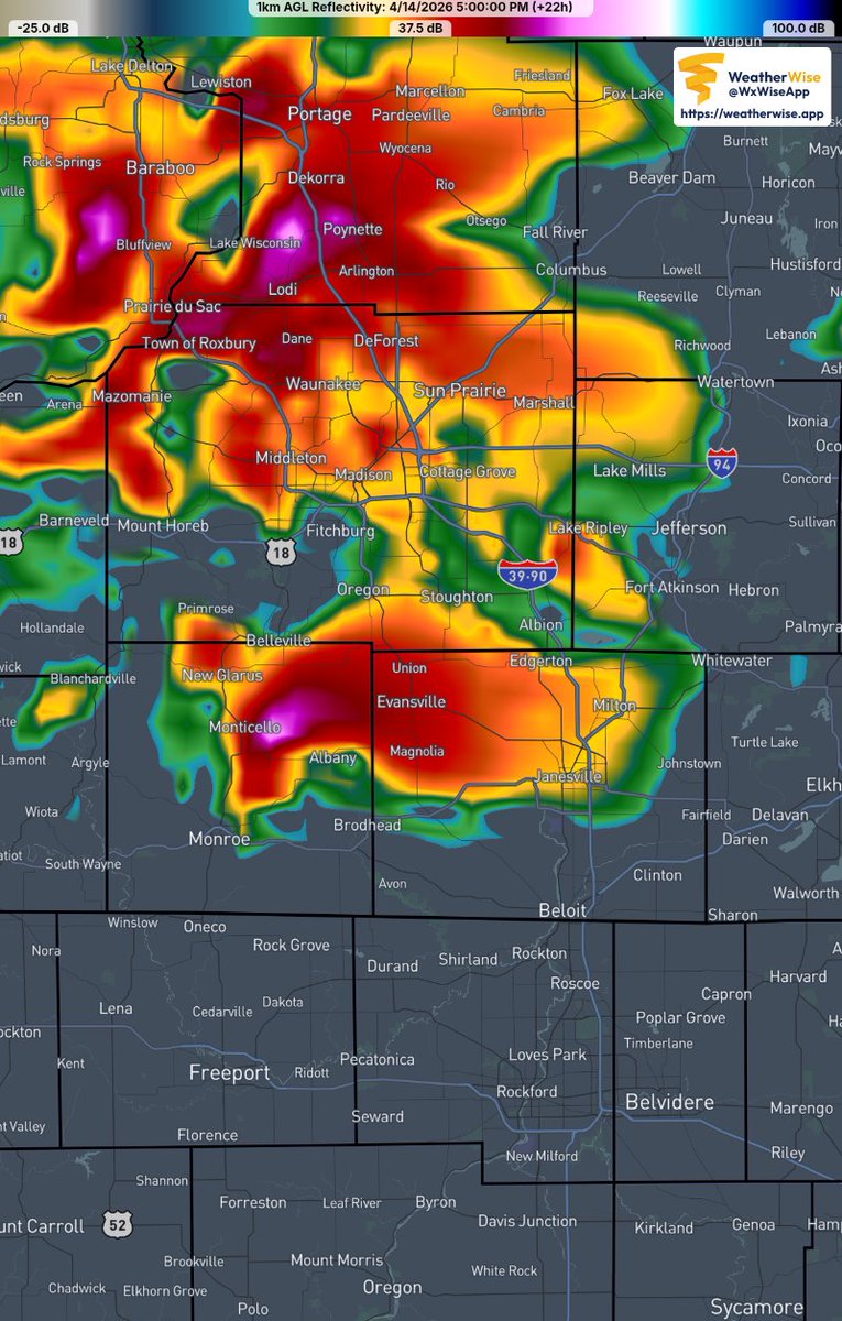
3" diameter hail reported on the west side of Madison. Via Dane County Emergency Management. #wiwx

5pm Radar Update: Very large hail to the size of baseballs has occurred with two storms in southern WI over the past hour. An increase in tornadic potential is expected over the next two hours. #wiwx


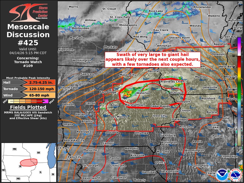
#WPC_MD 0102 affecting southern WI into central/northern Lower MI, #miwx #wiwx #iawx, wpc.ncep.noaa.gov/metwatch/metwa…
Brief break from storms Thursday during the day then another round of severe storms Friday afternoon/evening, especially for southwestern WI. Its still a few days out, but the forecast details may shift. #wiwx


With the severe weather winding down, we're collecting as many storm reports as possible. To help us focus on our storm surveys, we're looking for any potential damage reports from this afternoon/tonight's storms. Appreciate any information. Pic from Walworth Co EM. #wiwx
#WPC_MD 0105 affecting portions of Wisconsin and Michigan, #miwx #wiwx #ilwx, wpc.ncep.noaa.gov/metwatch/metwa…

#WPC_MD 0108 affecting southern Wisconsin, northern Illinois, #wiwx #ilwx #iawx, wpc.ncep.noaa.gov/metwatch/metwa…
Something went wrong.
Something went wrong.
United States Trends
- 1. #Survivor50 N/A
- 2. #AEWDynamite N/A
- 3. Rust N/A
- 4. Vientos N/A
- 5. Crosby N/A
- 6. Max Fried N/A
- 7. Mark Davis N/A
- 8. #IgniteTheOrange N/A
- 9. #AbbottElementary N/A
- 10. Jimmy Fallon N/A
- 11. Konecny N/A
- 12. Samoa Joe N/A
- 13. Grapefruit N/A
- 14. Will Ospreay N/A
- 15. Lio Rush N/A
- 16. Skinner N/A
- 17. Hung Cao N/A
- 18. #ChicagoFire N/A
- 19. Cirie N/A
- 20. Jalen Duren N/A