#eodata search results

🌎 The UK government plans to use #EOdata for academic, institutional, public & commercial services to improve their EO technologies. This will give 35 public sectors across the UK access to and pilot-test high-resolution EO data & services. tinyurl.com/y49nmcyx

🤝 The EU & Japan have strengthened their ties in space exploration by agreeing to share #EOdata with each other. As part of their agreement, Japan will give the EU's Copernicus programme access to data from its non-commercial EO satellites. tinyurl.com/ycxk8cr3

📡 #Satellitedata is now accessible to all businesses and offers incredible opportunities. From managing infrastructure risk to improving sustainability. Learn more about the power of #EOdata and seize the opportunity for your business. tinyurl.com/ycyjs48d

With the use of #EOdata, public services such as land use, environmental monitoring, and emergency response could be improved. Thirty-five public sector bodies across the UK are to have access to and pilot-test high-resolution EO data and services. bit.ly/3Mzkv52


Our second oral session at #AGU24 had some great presentations! We learned about new techniques for predicting crop yields at the scale of single fields; the use of SAR #EOdata for monitoring cropland flooding; and a lot more!


🚀 Advancing Air Quality Monitoring with Remote Sensing & GIS. Satellite-derived data + spatial analytics are transforming how we assess air pollution at scale. 📺 Full methodology & case studies: youtube.com/live/SuGfrWhMJ… #GeospatialAnalytics #AirPollution #EOData #Environmental


Hey @faricharly, look who we stumbled upon while observing Earth from space. #EOdata helps food producers monitor crops, yields, and artworks. We captured this portrait of a football idol near Los Cóndores, in the Córdoba Province, Argentina. @TraeUnBonarda @TeamMessi

🪐 Utilizing #EOdata from space allows us to gather vital information about Earth, leading to improved resource management, disaster response, infrastructure planning, environmental conservation, and climate change research. 💭 Got a question? bit.ly/43jbH9z

Ana Tárano, Ivan Zvonkov, and Hannah Kerner share how they’re strengthening food security in Maui County using #EOData, machine learning, and local knowledge. #AGU24 Learn more about their work here!👉 fooddive.com/news/nasa-ai-a…

We recently welcomed @AEM_mx executives for a tour of our Pilot Plant in Montevideo, Uruguay. This follows our LOI to develop a Constellation-as-a-Service program for multipurpose #EOdata across Mexico’s almost 2 million km².


NASA Harvest had so many presenters in different sessions this week at #AGU24! We’re happy to share some of them with you over the next few days! Gedeon Muhawenayo is studying the impact of conflict on agricultural land in Sudan using machine learning & #EOData.

Check out our September newsletter! 👉conta.cc/4dFGeCH Learn about our recent work using #EOData to map artillery craters and track unexploded ordnance in #Ukraine; how El Niño can give early warning of crop failures; and our NASA Harvest Latin America initiative!


📡 #EOdata combined with #AI & human analysis offers huge opportunities for more accurate risk modeling & faster claims management. Read here. tinyurl.com/s6fy6ma9 💭 Got a question? t.me/SpaceChainOffi… #DecentralizedTechnology #DSI #DSA


Our 2nd video features Mpho Sadiki, DE Africa EO Data Scientist, on how DE Africa makes high-quality EO data accessible to empower African nations. Using NASA’s Landsat & ESA’s Sentinel data, the DE Africa Data Cube helps track changes & support decision-making. #EOdata #GIS

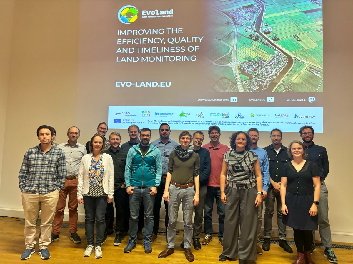
🚀 Excited to celebrate our midterm achievements & review in Munich! Presentations, workshops, and insightful visualisations that highlight the incredible work we've done so far! Stay tuned for more! #EOData #SatelliteTech #Innovation #openEO #MidtermReview @EU_HaDEA
A recent wildfire, allegedly ignited by visitors, impacted almost 100 km² (the size of Barcelona) of forests across Argentina's southernmost #TierraDelFuego province. Find out more about how #EOdata is used to prevent and respond to disasters like this: bit.ly/3WXXATU


Easier access to Sentinel data thanks to the new Copernicus Data Space Ecosystem copernicus.eu/en/news/news/e… + web portal dataspace.copernicus.eu from @CopernicusEU #earthobservation #eodata #opendata

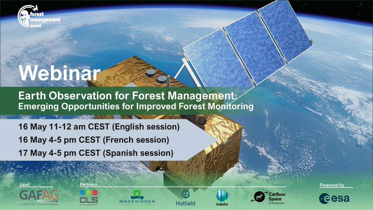
🛰️ #EOData for #ForestMonitoring and Activity Data mapping is an unprecedented value! Join us for a session exploring the latest advancements in ESA's missions and other EO data sources for your #forest management activities. Sign up: eo4sd-forest.info/webinars/ #ClimateAction
NASA Harvest teamed up with several of our partners to host a week long #EarthObservation training in Dakar, Senegal. The training provided more than a dozen participants with the skills to create and analyze #EOData products for resource management. 🔗nasaharvest.org/news/nasa-harv…


.@BeckerInbal, Director of the NASA Harvest Consortium, has been awarded NASA’s Exceptional Public Achievement Medal for her work supporting global food security & agricultural market stability through the uptake of #EOData. Congrats Inbal! 📖👉nasaharvest.org/index.php/news…

Our second oral session at #AGU24 had some great presentations! We learned about new techniques for predicting crop yields at the scale of single fields; the use of SAR #EOdata for monitoring cropland flooding; and a lot more!
🚀 Advancing Air Quality Monitoring with Remote Sensing & GIS. Satellite-derived data + spatial analytics are transforming how we assess air pollution at scale. 📺 Full methodology & case studies: youtube.com/live/SuGfrWhMJ… #GeospatialAnalytics #AirPollution #EOData #Environmental
Check out our September newsletter! 👉conta.cc/4dFGeCH Learn about our recent work using #EOData to map artillery craters and track unexploded ordnance in #Ukraine; how El Niño can give early warning of crop failures; and our NASA Harvest Latin America initiative!
Hey @faricharly, look who we stumbled upon while observing Earth from space. #EOdata helps food producers monitor crops, yields, and artworks. We captured this portrait of a football idol near Los Cóndores, in the Córdoba Province, Argentina. @TraeUnBonarda @TeamMessi
Ana Tárano, Ivan Zvonkov, and Hannah Kerner share how they’re strengthening food security in Maui County using #EOData, machine learning, and local knowledge. #AGU24 Learn more about their work here!👉 fooddive.com/news/nasa-ai-a…
🌎 The UK government plans to use #EOdata for academic, institutional, public & commercial services to improve their EO technologies. This will give 35 public sectors across the UK access to and pilot-test high-resolution EO data & services. tinyurl.com/y49nmcyx
📡 #Satellitedata is now accessible to all businesses and offers incredible opportunities. From managing infrastructure risk to improving sustainability. Learn more about the power of #EOdata and seize the opportunity for your business. tinyurl.com/ycyjs48d
Our November newsletter is out now! - El Nino forecast to impact crop yields across the globe - @MauiUnitedWay & Harvest collaborate for expedited wildfire aid - @CLNakalembe receives @AlSumaitPrize - Harvest at #AGU23 - #EOData for ag insurance 🔗conta.cc/3N4PN3w


🤝 The EU & Japan have strengthened their ties in space exploration by agreeing to share #EOdata with each other. As part of their agreement, Japan will give the EU's Copernicus programme access to data from its non-commercial EO satellites. tinyurl.com/ycxk8cr3
NASA Harvest had so many presenters in different sessions this week at #AGU24! We’re happy to share some of them with you over the next few days! Gedeon Muhawenayo is studying the impact of conflict on agricultural land in Sudan using machine learning & #EOData.
With the use of #EOdata, public services such as land use, environmental monitoring, and emergency response could be improved. Thirty-five public sector bodies across the UK are to have access to and pilot-test high-resolution EO data and services. bit.ly/3Mzkv52
NASA Harvest teamed up with several of our partners to host a week long #EarthObservation training in Dakar, Senegal. The training provided more than a dozen participants with the skills to create and analyze #EOData products for resource management. 🔗nasaharvest.org/news/nasa-harv…
🪐 Utilizing #EOdata from space allows us to gather vital information about Earth, leading to improved resource management, disaster response, infrastructure planning, environmental conservation, and climate change research. 💭 Got a question? bit.ly/43jbH9z
📡 #EOdata combined with #AI & human analysis offers huge opportunities for more accurate risk modeling & faster claims management. Read here. tinyurl.com/s6fy6ma9 💭 Got a question? t.me/SpaceChainOffi… #DecentralizedTechnology #DSI #DSA
🚀 Excited to celebrate our midterm achievements & review in Munich! Presentations, workshops, and insightful visualisations that highlight the incredible work we've done so far! Stay tuned for more! #EOData #SatelliteTech #Innovation #openEO #MidtermReview @EU_HaDEA
NASA Harvest & @agmatixhq are leveraging remote sensing to scale regenerative ag! Agmatix's RegenIQ framework uses #EOData & #AI to improve data collection; validate management practices; & guide decision-making across diverse growing regions. 👉🔗regeniq.earth/agmatix-nasa-h…

A recent wildfire, allegedly ignited by visitors, impacted almost 100 km² (the size of Barcelona) of forests across Argentina's southernmost #TierraDelFuego province. Find out more about how #EOdata is used to prevent and respond to disasters like this: bit.ly/3WXXATU
🛰️ #EOData for #ForestMonitoring and Activity Data mapping is an unprecedented value! Join us for a session exploring the latest advancements in ESA's missions and other EO data sources for your #forest management activities. Sign up: eo4sd-forest.info/webinars/ #ClimateAction
Our September newsletter is out now! - Using #EOData for disaster response with @UNDRR - 20 years of field-scale maize and soybean planting date maps - NASA Harvest receives @ArrellFoodInst 2023 Research Innovation Award and more! 🔗conta.cc/3ZD1Ni8


Something went wrong.
Something went wrong.
United States Trends
- 1. Raindotgg 1,611 posts
- 2. #TalusLabs N/A
- 3. Sam Houston 1,441 posts
- 4. Oregon State 4,809 posts
- 5. #T1WIN 23.5K posts
- 6. Boots 29.1K posts
- 7. Boots 29.1K posts
- 8. Louisville 14.4K posts
- 9. #GoAvsGo 1,527 posts
- 10. Batum N/A
- 11. UCLA 7,794 posts
- 12. Emmett Johnson 2,448 posts
- 13. #Huskers 1,088 posts
- 14. Oilers 4,977 posts
- 15. #FlyTogether 2,005 posts
- 16. Miller Moss 1,221 posts
- 17. Nuss 5,813 posts
- 18. T1 FIGHTING 3,342 posts
- 19. Bama 13.9K posts
- 20. Brohm 1,156 posts