
Md Mijanur Rahman🛰️🗺️🛰️
@GISRSStudyHacks
Geospatial Trainer🌎I teach the skills you need to become an expert geospatial professional in any industry.
You might like


For more information about registration, visit our website: studyhacksgeospatial.com/google-earth-e… #GoogleEarthEngine #RemoteSensing #GIS #GeospatialAnalysis #OnlineTraining #CodingForBeginners #PythonAPI #JavaScriptAPI #LULCMapping #ChangeDetection #AirQualityMonitoring #TimeSeriesAnalysis

🔥 Land Surface Temperature (LST) Mapping of Bangladesh – Year 2023 🛰️ 🌐 Register Info Link: studyhacksgeospatial.com/google-earth-e… #LST #GoogleEarthEngine #RemoteSensing #Bangladesh #StudyHacks #UrbanHeatIsland #ClimateChange #GIS #Research

For more information about registration, visit our website: studyhacksgeospatial.com/google-earth-e… For Registration, Contact this Email: [email protected] Or WhatsApp 24/7: +8801780942798 or wa.me/8801780942798 #googleearthegine #GIS #remotesensing

For more information about registration, visit our website: studyhacksgeospatial.com/google-earth-e… #GoogleEarthEngine #RemoteSensing #GIS #GeospatialAnalysis #OnlineTraining #JavaScript #Python #DataScience #GeospatialSkills #NonCoders #TrainingCourse #EarthObservation #SpatialAnalysis

🌿 Vegetation Analysis using Sentinel-1 SAR Data via Radar Vegetation Index (RVI) Tutorial Link: youtu.be/hJfrl-BPEw8 For more information about registration, visit our website: studyhacksgeospatial.com/google-earth-e… #Sentinel1 #SAR #VegetationAnalysis #RVI #GoogleEarthEngine #RemoteSensing

🚀 Registration Open | 35th Batch: 7-Day Live Training on Google Earth Engine (GEE) 🌎 🔗 Registration Info : studyhacksgeospatial.com/google-earth-e… @googleearthengine #remotesensing #GIS #Training

Tutorial about Hydrological Analysis in Google Earth Engine. Flow Accumulation, Stream, and Watershed Mapping Tutorial Link: youtu.be/1dGB-ZJnYP8 #HydrologicalAnalysis #GoogleEarthEngine #FlowAccumulation #StreamMapping #WatershedMapping #GeospatialAnalysis #RemoteSensing

Precision Agriculture Explained: Estimating Water Use Coefficient with Remote Sensing. Tutorial Link: youtu.be/pGf0ukESYnA?si… For more information about registration, visit our website: studyhacksgeospatial.com/google-earth-e… #googleearthengine #GIS #remotesensing

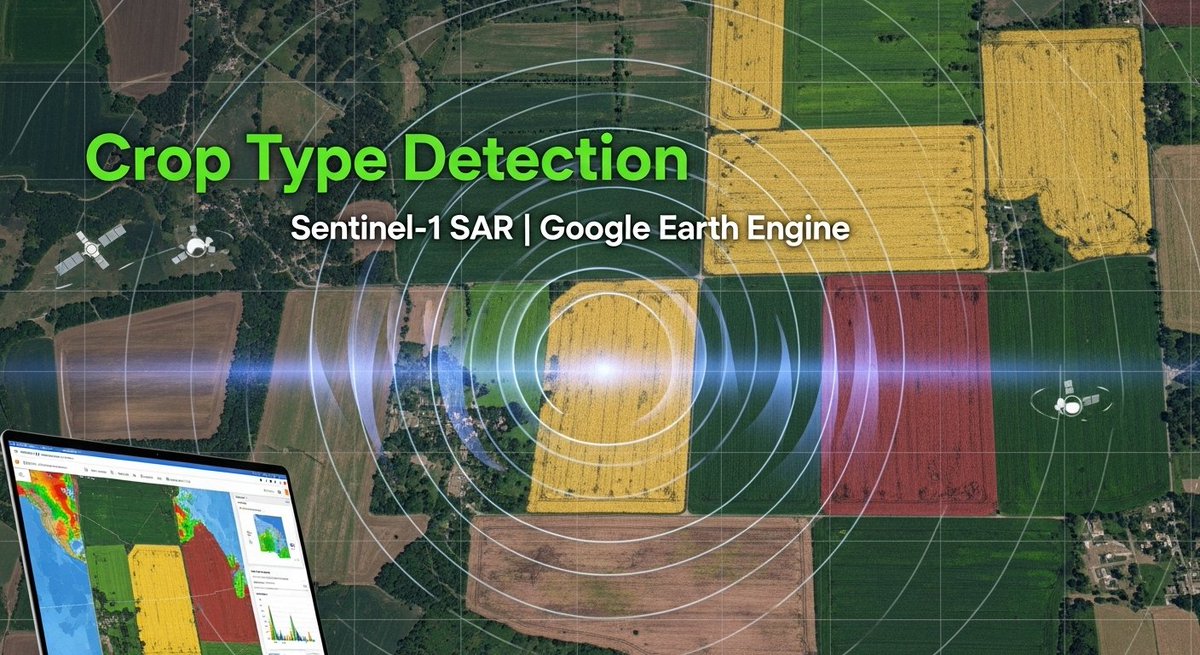
Tutorial about Crop Type Detection Using Sentinel-1 SAR Imagery in Google Earth Engine. Tutorial Link: youtu.be/b8P0d9GXsoQ?si… Registration: studyhacksgeospatial.com/google-earth-e… #GoogleEarthEngine #GEE #EarthEngine
Estimating Soil Moisture with OPTRAM Using Landsat & Sentinel 2 Data Tutorial Link: youtu.be/jREo0T_qfsQ #SoilMoisture #OPTRAM #Landsat #Sentinel2 #RemoteSensing #EarthObservation #AgricultureTech #PrecisionAgriculture #DataScience #EnvironmentalMonitoring #SustainableFarming

Remote Sensing training for Forest Management using Google Earth Engine Recorded class link: youtube.com/live/8tDdd2kNy… For more information about registration, visit our website: studyhacksgeospatial.com/google-earth-e… #RemoteSensing #ForestManagement #GoogleEarthEngine #GeospatialAnalysis

How to make a map layout using ArcMap? Map created using ArcGIS. Tutorial Link: youtu.be/gGdJzmyGasE For more information about registration, visit our website: studyhacksgeospatial.com/google-earth-e… #ArcMap #ArcGIS #MapLayout #GIS #Geospatial #Cartography #Mapping #DataVisualization
For more information about registration,visit our website: studyhacksgeospatial.com/google-earth-e… #GoogleEarthEngine #RemoteSensing #GIS #GeospatialAnalysis #OnlineTraining #JavaScript #PythonAPIs #NonCoders #GeospatialSkills #DataScience #EarthObservation #EnvironmentalScience #SpatialAnalysis

Tutorial about Land use and land cover classification using machine learning algorithms Tutorial Link:youtu.be/pif55v-9k24 Registration link: studyhacksgeospatial.com/google-earth-e… #LandUse #LandCover #MachineLearning #RemoteSensing #GeospatialAnalysis #DataScience #AI #DeepLearning #GIS

Tutorial about Air Quality Monitoring using Remote Sensing Techniques: O3, NO2, SO2, HCHO, CHOCHO and aerosols, CO Tutorial Link: youtube.com/live/4Apgk1Fbl… #AirQualityMonitoring #RemoteSensing #Ozone #NO2 #SO2 #HCHO #CHOCHO #Aerosols #CO #EnvironmentalScience #AirPollution

Tutorial Sentinel-1 InSAR processing workflow with SNAP, part: 1 Tutorial Link: youtu.be/jeK81Gn_Ugw #Sentinel1 #InSAR #SNAP #RemoteSensing #EarthObservation #SatelliteImagery #GeospatialAnalysis #DataProcessing #Tutorial #GIS #EnvironmentalMonitoring

Tutorial about Land use and Land cover Future prediction using Machine learning Tutorial Link: youtube.com/live/v9VMWkxJP… #LandUse #LandCover #MachineLearning #FuturePrediction #GeospatialAnalysis #RemoteSensing #DataScience #AIinAgriculture #SustainableDevelopment #Environment

Tutorial about Drought Monitoring using VHI, VCI, TCI in Google Earth Engine. Tutorial Link: youtube.com/live/74_EkBBu1… registration, visit our website: studyhacksgeospatial.com/google-earth-e… #googleearthengine #remotesensing #gis #geospatial


United States Trends
- 1. Daboll 36.1K posts
- 2. Pond 239K posts
- 3. Schoen 18.7K posts
- 4. Veterans Day 21.5K posts
- 5. Zendaya 9,025 posts
- 6. Giants 70.6K posts
- 7. #jimromeonx N/A
- 8. Hanoi Jane 1,186 posts
- 9. Go Birds 11.9K posts
- 10. Joe Burrow 6,021 posts
- 11. Joe Dirt N/A
- 12. Dart 22.2K posts
- 13. Bowen 9,835 posts
- 14. Marines 64.9K posts
- 15. NCAA Tournament 1,580 posts
- 16. Kim Davis 13.6K posts
- 17. Jeffries 41.6K posts
- 18. Biker 3,781 posts
- 19. Johnny Carson N/A
- 20. #ROBOGIVE 1,235 posts


Something went wrong.
Something went wrong.