#pawx search results

Friday PM Update 🌦️: Warm with mixed clouds/sun and scattered thundershowers developing over Central PA. Tonight 🌧️: Storms diminish to showers later this evening, with showers & drizzle becoming more numerous overnight as cool/moist air noses in from the Northeast. #pawx

Tonight: 🌧️ Cool/drizzly in wake of steady rain. 🆒🌡️ Lows in the upper 30s and lower 40s across Central PA. Sunday/Monday: 🌤️ Showers end Sunday AM, with clouds breaking up in the afternoon. 😎 Abundant sunshine on Monday, with chances of rain returning on Tuesday. #PAwx
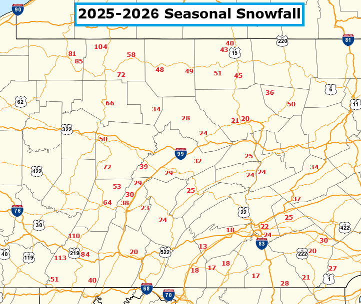
Here's how much snow has fallen across Central #PAwx through the winter of 2025-2026. Sites are NWS Co-Operative Observation Locations. Generally below normal for most of the area - especially in the south-central counties - in line with their current drought conditions.
Mild & dry today (Highs 58-65°). 🌥️ Rain arrives late tonight, continuing through Saturday. 🌧️ a little wet snow may mix in for high elevations Sat night. ☀️ Sun returns Monday! #NYWX #PAWX


Record Warmth --> Thunderstorms --> Cold Weather A strong cold front on Saturday will usher in some big changes on the horizon! Widespread frost/freeze conditions are expected on Tuesday, which could pose problems after such a warm March & early April! #PAwx


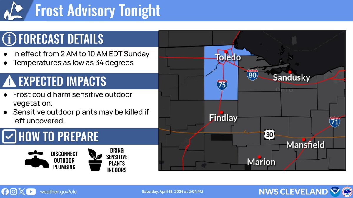
🧊🪴 Frost Advisory for east-central PA tonight: protect sensitive outdoor plants by moving them indoors or covering them. 🌡️ Temps trend well above average this week as high pressure settles offshore. 🌧️ Scattered showers mainly over NW PA throughout the week, drier SE. #PAwx

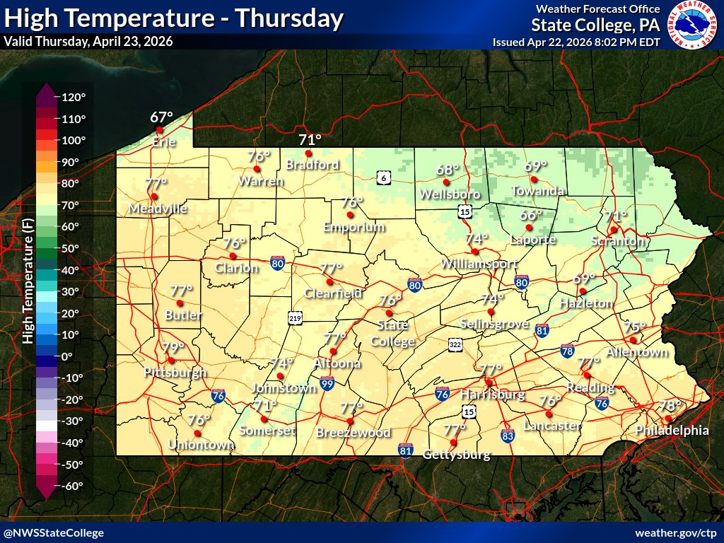
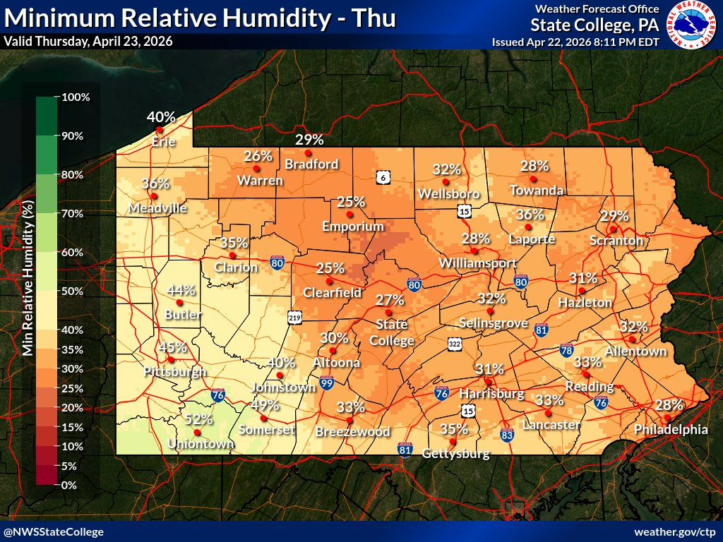
Thursday will be a gorgeous day for most of Pennsylvania: cloud-free skies, light winds, low relative humidity, and no rain! #PAwx


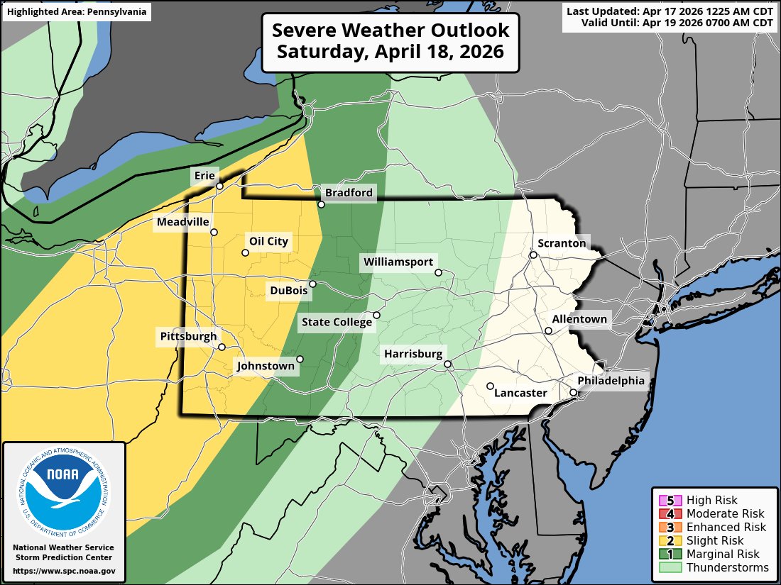
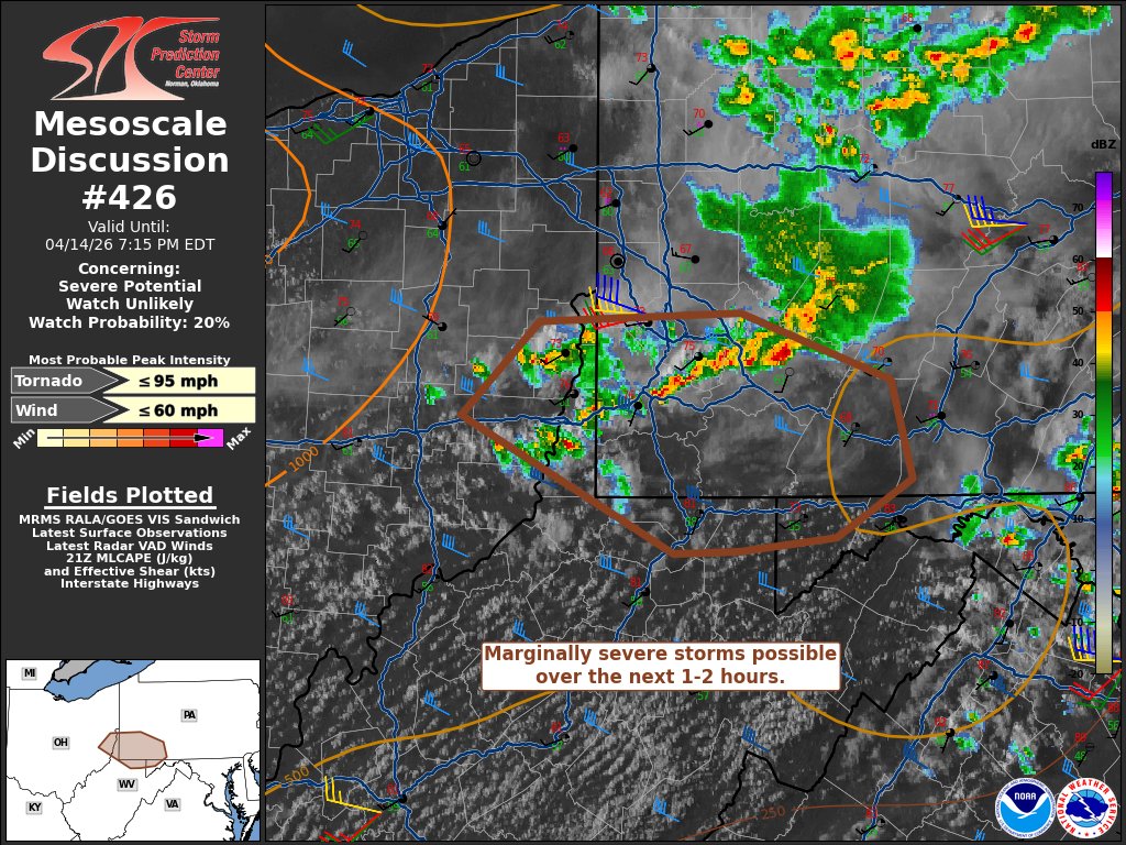
SATURDAY AM UPDATE: 🔥Be alert for elevated wildfire spread conditions this afternoon in southwest PA with gusty south winds & RH values dipping into the low 30s or upper 20s. ⛈️The latest Slight Risk of severe weather was expanded a bit farther east this forecast cycle. #PAwx

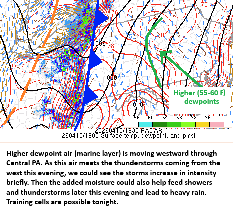
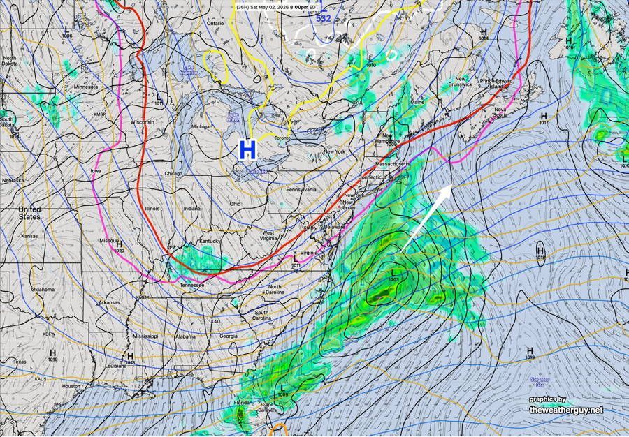
Surge of higher dewpoint air is moving toward the storms and cold front moving into PA. Rain become heavier later this evening and early tonight over central #PAwx. Some threat for flash flooding exists, mainly north of I-80.

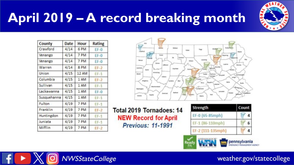
Today marks the 7 year anniversary of the April 14-15, 2019 severe weather event. There were 2 EF-2 tornadoes and 2 EF-1 tornadoes. This also kicked of an extremely active stretch of weather, where PA saw more than their annual average number of tornadoes in just 6 days. #PAwx

Early today: ☔ Scattered showers will exit eastward through this morning. This afternoon: 🌦️ A few lingering showers over east-central PA, otherwise partly sunny. 🌡️ Highs in the 60s & 70s. 🌬️ Light NW breeze (10-15 mph) over west/central PA; light winds over eastern PA. #PAwx
Following one of the WARMEST stretches over the last 3-4 weeks, confidence continues to build toward cooler end of April into early May. #PAwx
An unseasonably cold pattern is favored across most of the central and eastern US end of April into early May. Possible much below normal temperatures and near freezing low temperatures across parts of the Upper Midwest and Great Lakes region could damage early blooming crops.


The April 29, 2025 Ohio–Pennsylvania derecho will be one year old in about twenty days. It brought by far the most intense winds I have ever experienced. I set up just west of the Pittsburgh radar in Robinson Township. #wxtwitter #pawx #ohwx
Moments before 70+ mph sustained winds hit my location in west Pennsylvania. 4/29/25 #wxtwitter #pawx

Just a bit of light rain tonight, especially across the northern tier. Then we'll stay dry through Friday as temperatures continue to trend warmer each day. #PAwx
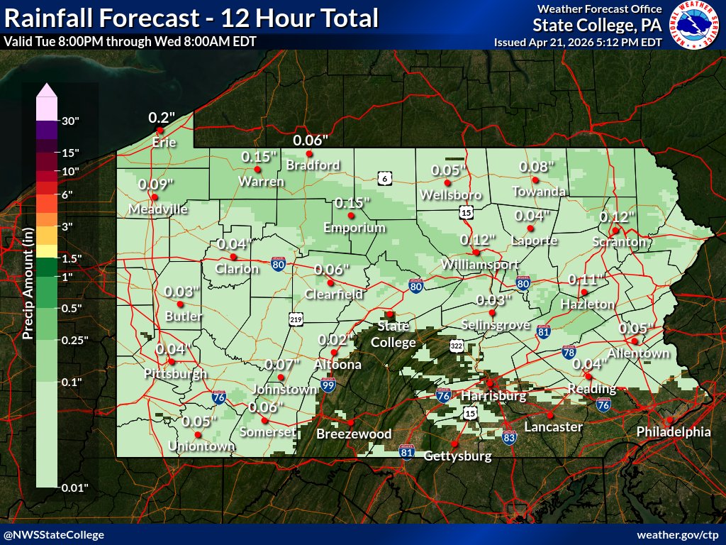
It is Sunday, April 19th. Our weather changes a lot through early this week as a much colder air mass settles in. Showers through about early this afternoon from west to east, then much colder tonight. A widespread freeze early Tuesday morning! #pawx #njwx #dewx #mdwx
Tonight: ☁️🌙 Seasonally mild with increasing clouds. Lows in the 40s & 50s. Friday: ⛅ 🌡️ Partly sunny and warm with highs ranging from the lower 60s (NE) to the upper 70s (SW). 🌦️ Spotty AM showers, then scattered PM thundershowers, primarily over west-central PA. #pawx


🍃 BREEZY THURSDAY As low pressure moves away, expect sustained NW winds at 10-20 mph. Winds will diminish tonight. #PAwx


Here's how the month of April shook out. wtrf.com/weather/the-mo… #WVWX #ohwx #pawx #WestVirginia #Ohio #april #climate #weather #friday @WTRF7News @StormTracker7


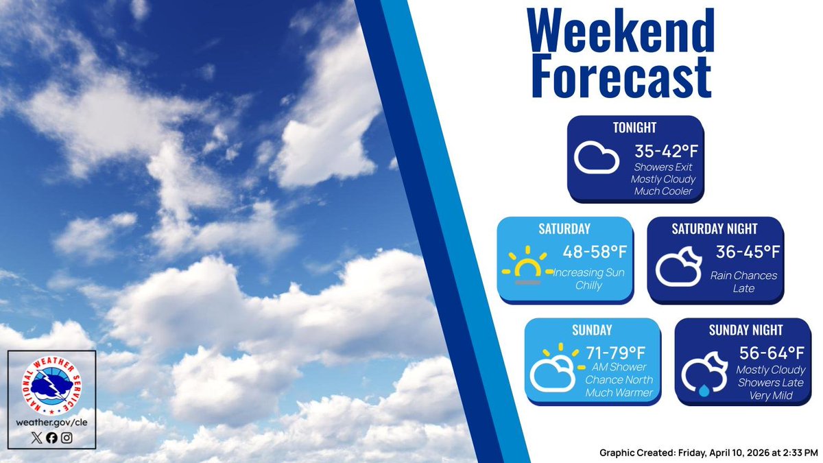
We will see a dry weekend with clouds and some sunny breaks Saturday followed by a little more sun on Sunday. But the going theme with temps continues...running a little below normal with highs near 60. Breezy Sunday. Frost/freeze conditions in the Poconos Sat. night. #PAwx #NJwx


Frost Advisory tonight. wtrf.com/weather/frost-… #WVWX #ohwx #pawx #Frost #WestVirginia #Ohio #weather #coldweather #friday @WTRF7News @StormTracker7


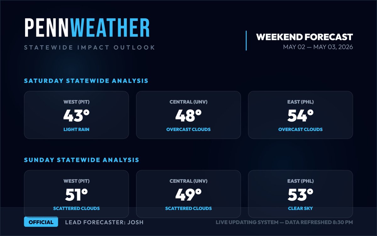
We're looking at a pretty nice weekend overall across the Commonwealth, most of the state should be dry with the exception of Western PA on Saturday with some light rain around. Highs this weekend 40s-50s across the state. #PAwx pennweather.weebly.com
WEEKEND WEATHER FORECAST — #Philadelphia #weather #PAwx #PhillyWx A weak cold front moves through after midnight tonight (Fri) with light scattered showers. Very cool high pressure builds in with a dip in the jet .. buff.ly/KiP2xIU
Get ready for some cold nights. I'm tracking when we're back into the 70s, though. wtrf.com/wheeling/wheel… #WVWX #ohwx #pawx #WestVirginia #Ohio #weather #forecast #friday #coldweather #fun @WTRF7News @StormTracker7


Frost and freeze alerts tonight 🥶🌱 Be sure to cover up plants and crops already in the ground and bring the potted plants inside. #pawx @WTAE

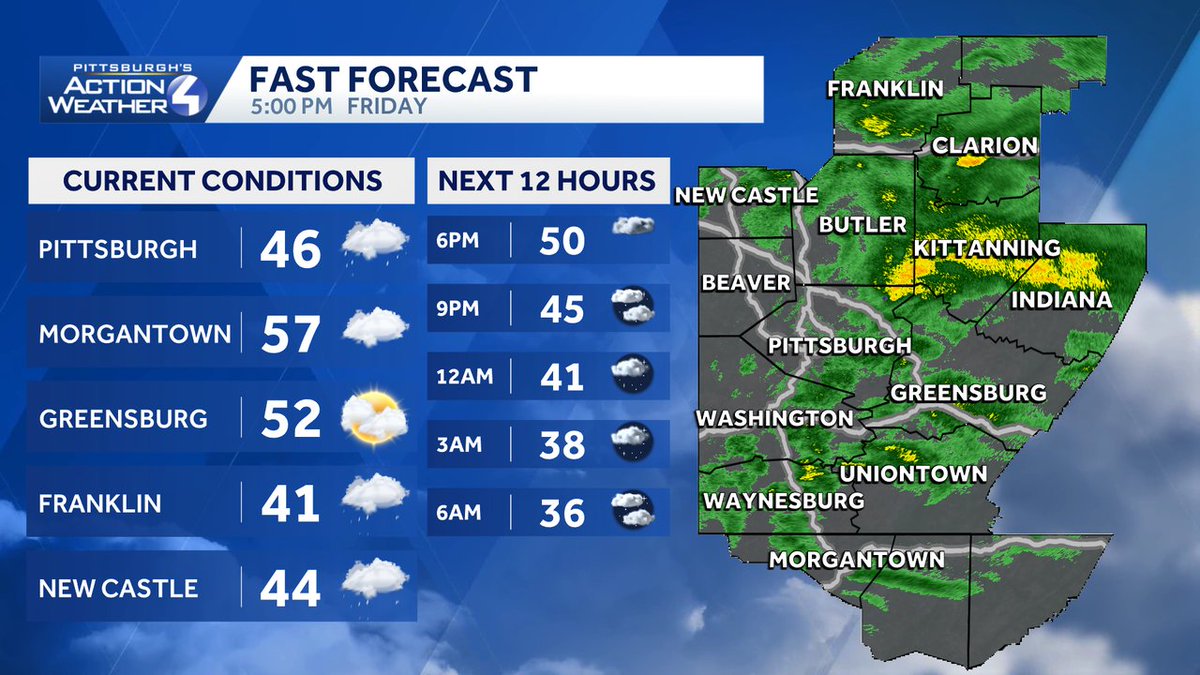
Here's a look at your evening conditions, temperatures, and radar around Western PA along with your forecast heading into tonight! #pawx
We've brought back the 7 Day Forecasts, but this time automatically updating straight from the website! For your local 7 Day Forecast visit pennweather.weebly.com/7dayforecast #PAwx

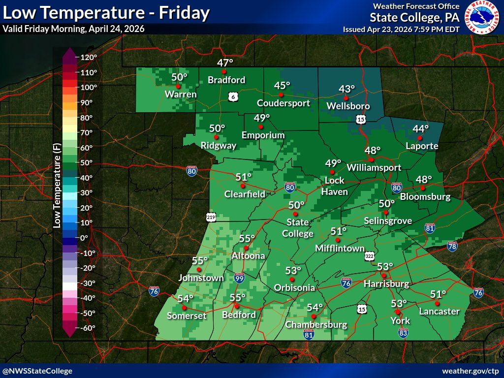
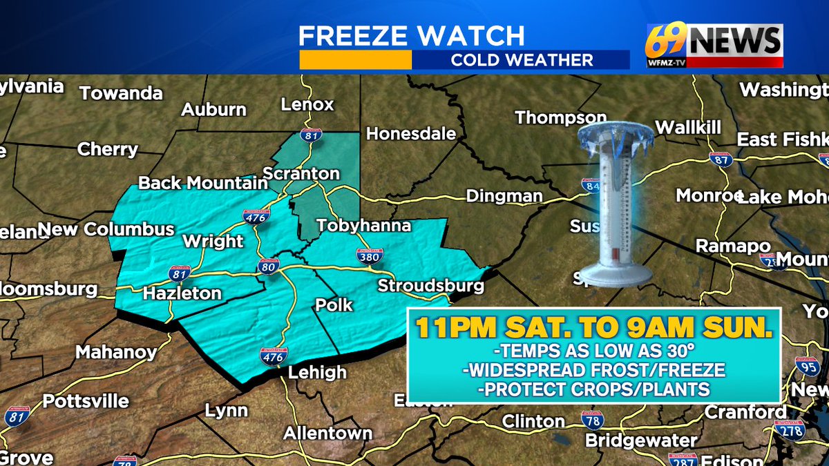
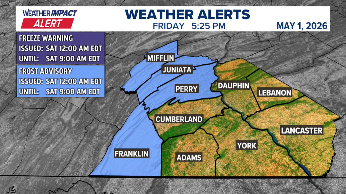
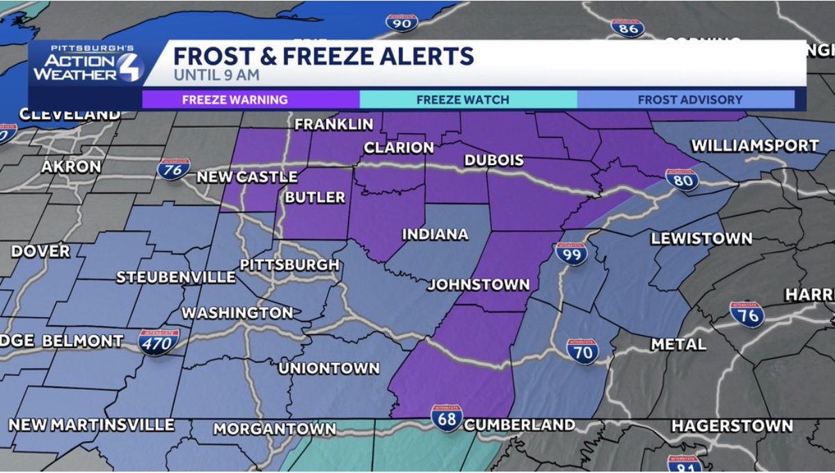
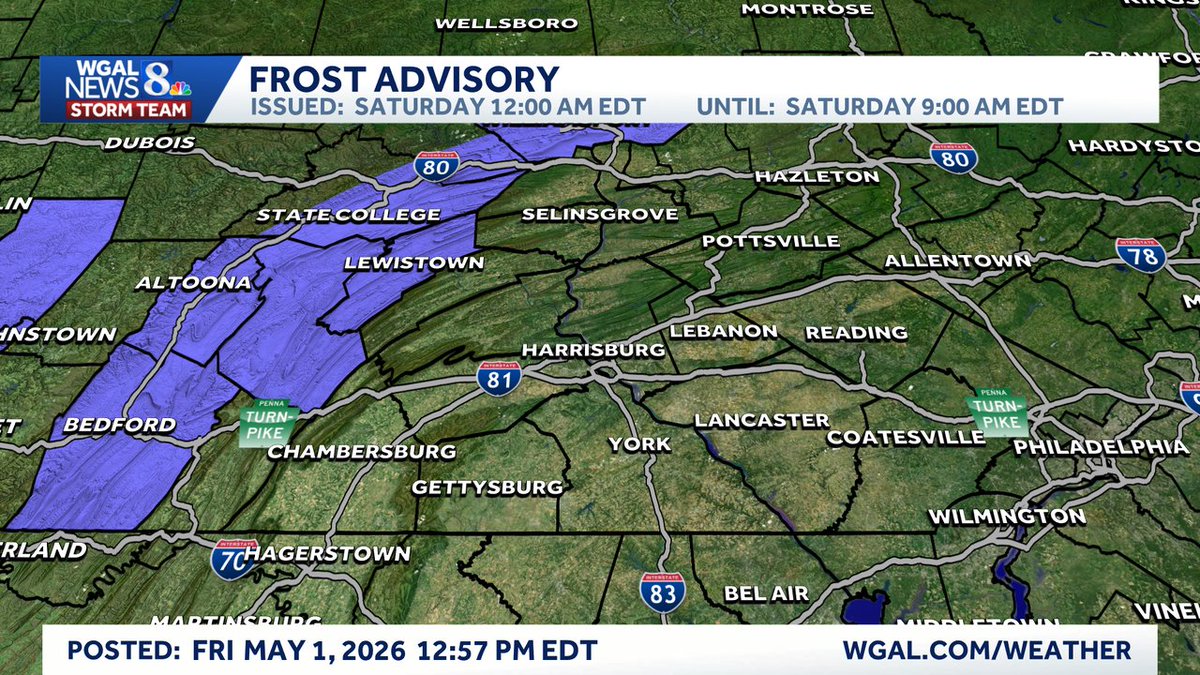
A Frost Advisory has been issued for highlighted counties until May 02 9:00AM. A widespread frost is expected in the highlighted areas. Stay tuned to WGAL and wgal.com/weather for the latest. @WGAL #PAwx #ColdWeather


A Frost Advisory has been issued for highlighted counties until May 02 9:00AM. A widespread frost is expected in the highlighted areas. Stay tuned to WGAL and wgal.com/weather for the latest. @WGAL #PAwx #ColdWeather


A Frost Advisory has been issued for highlighted counties until May 02 9:00AM. A widespread frost is expected in the highlighted areas. Stay tuned to WGAL and wgal.com/weather for the latest. @WGAL #PAwx #ColdWeather

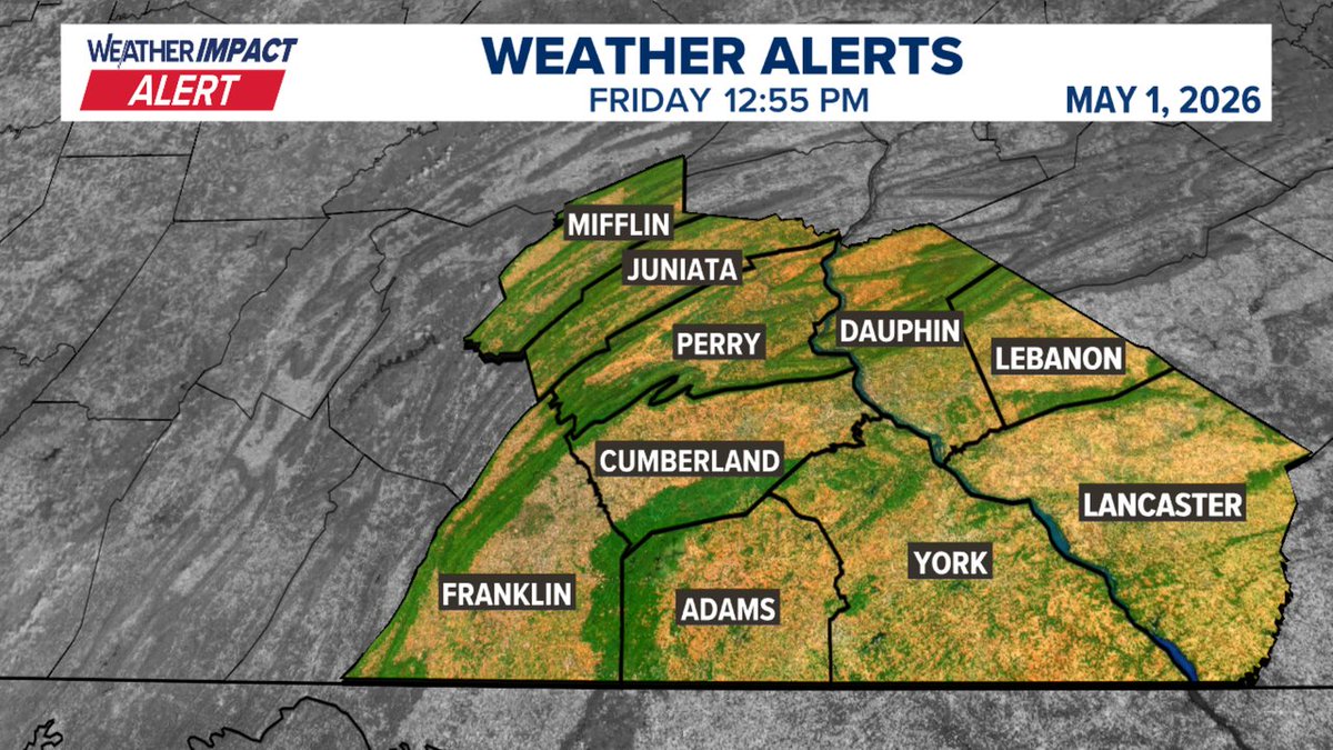
A Frost Advisory has been issued for the following areas in South Central PA. For more information, go to Fox43.com/weather #PAwx

A Frost Advisory has been issued for highlighted counties until May 02 9:00AM. A widespread frost is expected in the highlighted areas. Stay tuned to WGAL and wgal.com/weather for the latest. @WGAL #PAwx #ColdWeather


A Frost Advisory has been issued for highlighted counties until May 02 9:00AM. A widespread frost is expected in the highlighted areas. Stay tuned to WGAL and wgal.com/weather for the latest. @WGAL #PAwx #ColdWeather


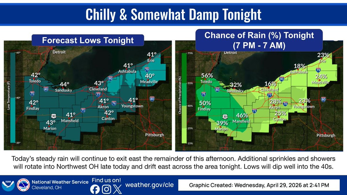
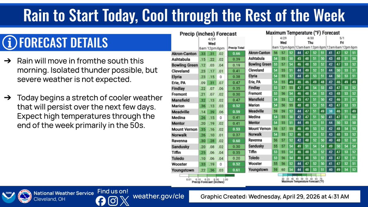
Today's rain will continue exiting east this afternoon, with scattered showers moving into Northwest OH and then drifting east across the area tonight. Lows will dip into the low to mid 40s. #OHwx #PAwx
Damp start to the day, and beginning a cool trend. 50s for the next few days, and possible frost/freeze issues for the end of the week and into the weekend! #ohwx #pawx
Warm and unsettled weather expected through this week. Breezy with showers, and maybe a stray thunderstorm, today. There's an increased risk of thunderstorms and severe weather on Tuesday. Showers persist Wednesday and Thursday before clearing out on Friday. #ohwx #pawx

Friday PM Update 🌦️: Warm with mixed clouds/sun and scattered thundershowers developing over Central PA. Tonight 🌧️: Storms diminish to showers later this evening, with showers & drizzle becoming more numerous overnight as cool/moist air noses in from the Northeast. #pawx
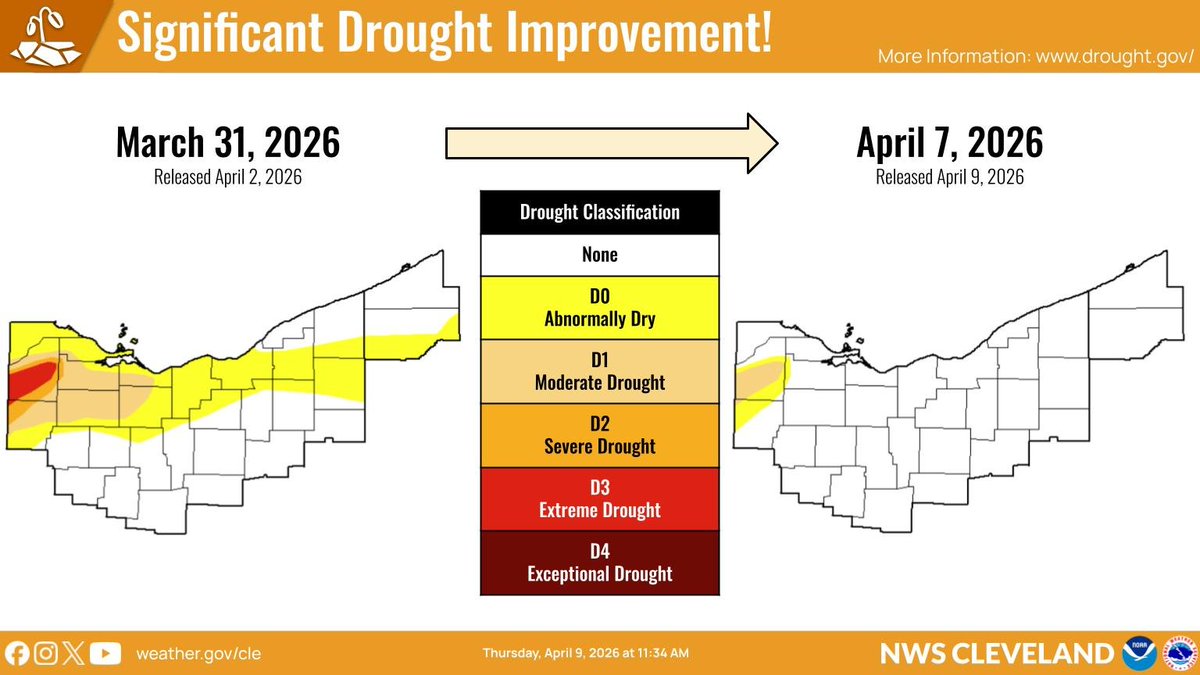
At the end of March, most of Northwest OH remained in drought ranging from moderate to extreme severity, with abnormally dry conditions extending east across parts of the area. After all of the rain we've seen since then, most of the area is no longer in a drought. #OHwx #PAwx
Below average temperatures to start the week with periodic precipitation chances into Tuesday. Lingering rain/snow showers likely across NE OH & NW PA tonight through Tuesday morning. Warmer temperatures starting Wednesday with another chance for rain on Friday. #OHwx #PAwx

Tonight: ☁️🌙 Seasonally mild with increasing clouds. Lows in the 40s & 50s. Friday: ⛅ 🌡️ Partly sunny and warm with highs ranging from the lower 60s (NE) to the upper 70s (SW). 🌦️ Spotty AM showers, then scattered PM thundershowers, primarily over west-central PA. #pawx
We will see a dry weekend with clouds and some sunny breaks Saturday followed by a little more sun on Sunday. But the going theme with temps continues...running a little below normal with highs near 60. Breezy Sunday. Frost/freeze conditions in the Poconos Sat. night. #PAwx #NJwx
Much cooler but drier weather arrives overnight tonight into Saturday before warm weather quickly returns on Sunday. A few showers are possible late Saturday night into early Sunday morning, and again late Sunday night into Monday morning. #OHwx #PAwx

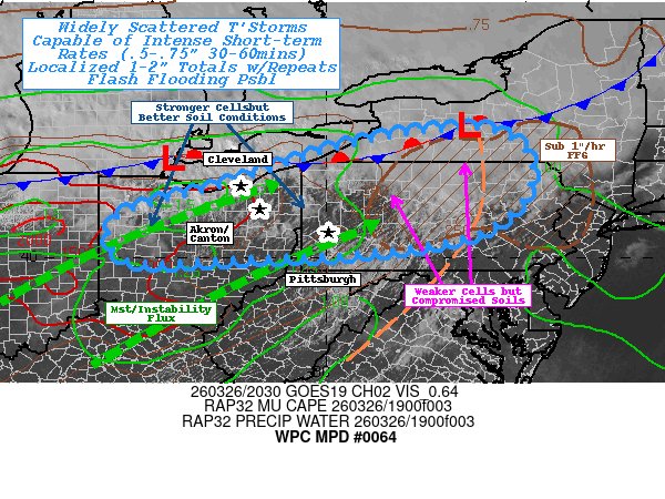
#WPC_MD 0064 affecting Northern Ohio...Western & Central PA... Southwest NY..., #nywx #pawx #wvwx #ohwx, wpc.ncep.noaa.gov/metwatch/metwa…
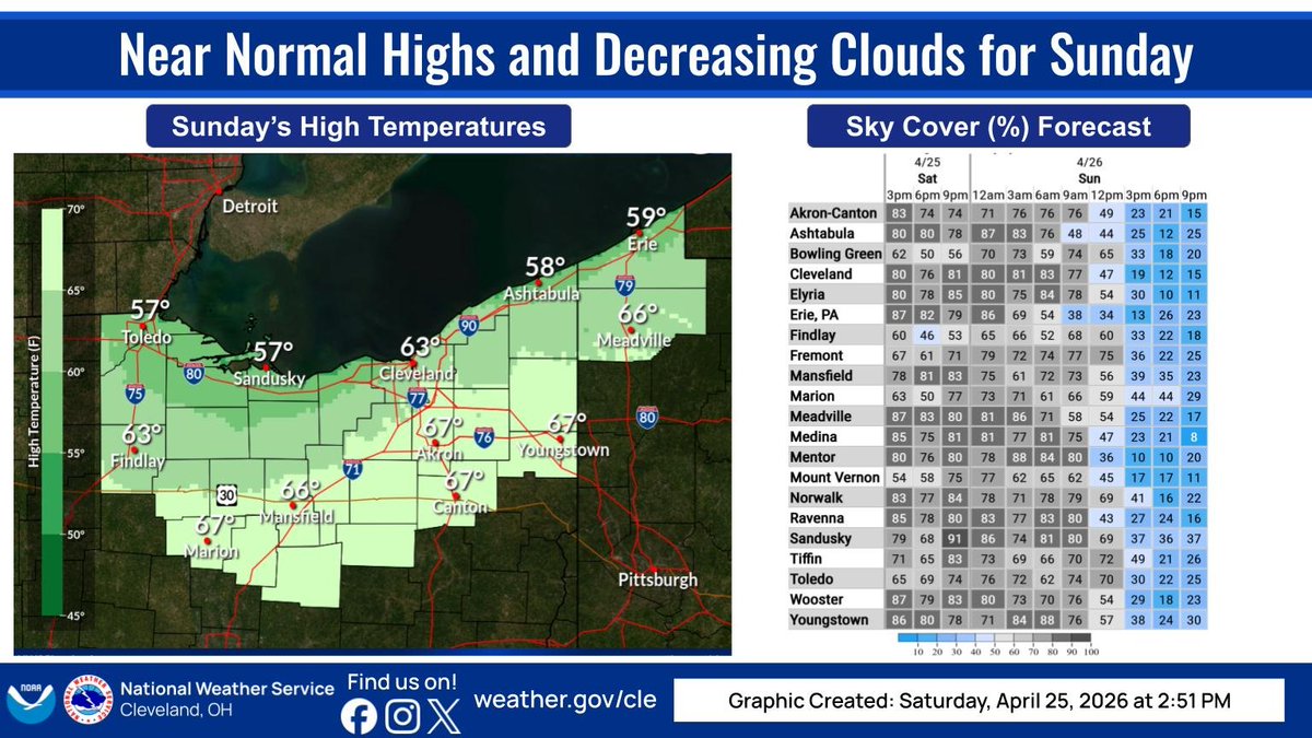
Temperatures on Sunday will reach near normal values for most areas except a northeast wind will keep readings a little cooler near Lake Erie. Persistent cloud cover will start to thin by midday on Sunday. #ohwx #pawx
Lingering showers and storms are exiting to the east. Did you see hail, wind damage, or flooding in your area with the storms that moved through this afternoon and evening? Let us know below! #OHwx #PAwx


A cold front will push through today and then stall just to our southeast into Wednesday as a wave of low pressure tracks along it. Scattered showers accompany the front today with another round of rain late tonight into Wednesday, followed by a cool down. #OHwx #PAwx

Chilly nights ahead! Take proactive steps now to cover sensitive plants, as freeze headlines are active tonight and tomorrow night. #ohwx #pawx

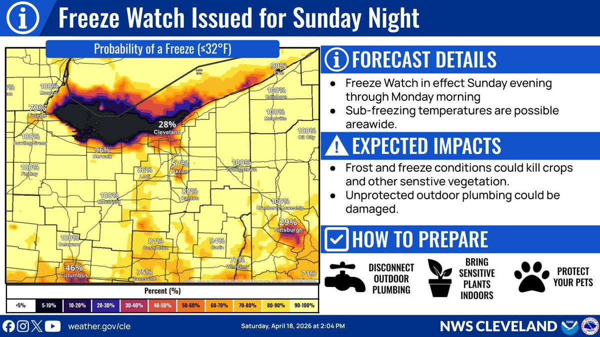
A Frost Advisory is in effect tonight into Sunday AM for portions of Northwest Ohio. A Freeze Watch has also been issued for the entire forecast area Sunday PM into Monday AM. Protect sensitive plants! #ohwx #pawx
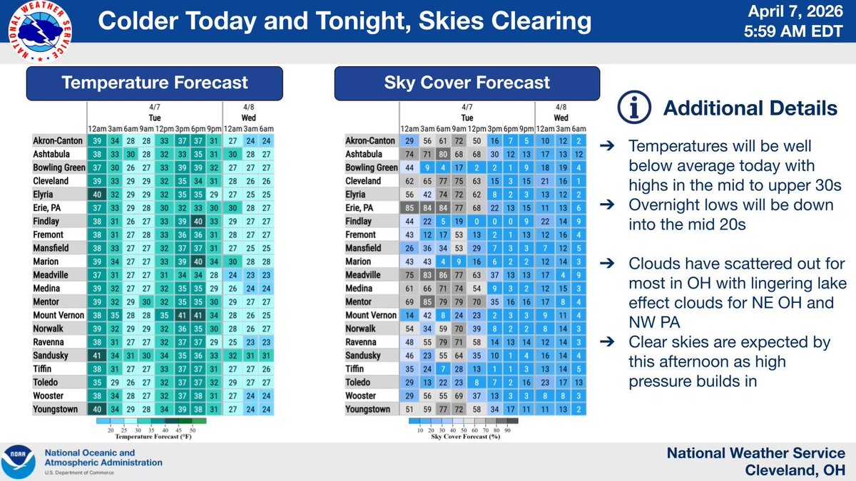
Temperatures will be well below average today behind a cold front that moved through early this morning. High will only be in the mid to upper 30s with lows tonight down in the mid 20s. Clouds will continue to clear out throughout the day as high pressure builds in. #OHwx #PAwx
🧊🪴 Frost Advisory for east-central PA tonight: protect sensitive outdoor plants by moving them indoors or covering them. 🌡️ Temps trend well above average this week as high pressure settles offshore. 🌧️ Scattered showers mainly over NW PA throughout the week, drier SE. #PAwx
Something went wrong.
Something went wrong.
United States Trends
- 1. #SmackDown N/A
- 2. RJ Barrett N/A
- 3. Magic N/A
- 4. Toronto N/A
- 5. Cavs N/A
- 6. McAvoy N/A
- 7. Game 7 N/A
- 8. Pistons N/A
- 9. #OPLive N/A
- 10. Mobley N/A
- 11. Bruins N/A
- 12. #LetsGoBuffalo N/A
- 13. Benson N/A
- 14. #BostonBlue N/A
- 15. #LetEmKnow N/A
- 16. Donovan Mitchell N/A
- 17. Money Mike N/A
- 18. Sami N/A
- 19. Kawhi N/A
- 20. Scottie Barnes N/A