#3dmapping search results

Coming in July! 📘 𝘔𝘢𝘱𝘱𝘪𝘯𝘨 𝘸𝘪𝘵𝘩 𝘈𝘭𝘵𝘪𝘵𝘶𝘥𝘦: 𝘋𝘦𝘴𝘪𝘨𝘯𝘪𝘯𝘨 3𝘋 𝘔𝘢𝘱𝘴 by @NathanCShephard explores concepts, challenges, and opportunities in 3D cartography using easy-to-follow workflows. esri.social/aXuA50S95Fb #3DMapping #Cartography


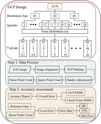
2100+ views 🔥 UAV 3D mapping accuracy secret cracked! GCP reliability sets accuracy ceiling—high RMSE (0.1m)? Prioritize quantity 📏; low (5m+)? Edge+center distribution 🌍. Errors spike in rough terrain! #UAVPhotogrammetry #GCPHacks #3DMapping #GISTrends #DroneTech

Every dataset hides a landscape. Give it height & light, and it speaks. I packed that magic into 30 video tutorials on 3D rendering: one project per video ⤵️ youtube.com/playlist?list=… Dive in, share your dream map below! 👇 #GIS #3DMapping #DataViz #Cartography #OpenSource

Check out our latest blog post on "Efficient and Distributed Large-Scale 3D Map Registration using Tomographic Features" proposing a robust, resource-efficient, and distributed 3D map matching algorithm. Learn more at: bit.ly/4eJyod6 #3Dmapping #efficiency

Excited about 3D mapping? 🌍Check out this LIDAR PointCloud project! Integrate a LIDAR sensor & stepper motor to scan & visualize spatial data. Perfect for robotics & more! 🤖For more details: instructables.com/LIDAR-PointClo… #DIY #3DMapping #LiDAR


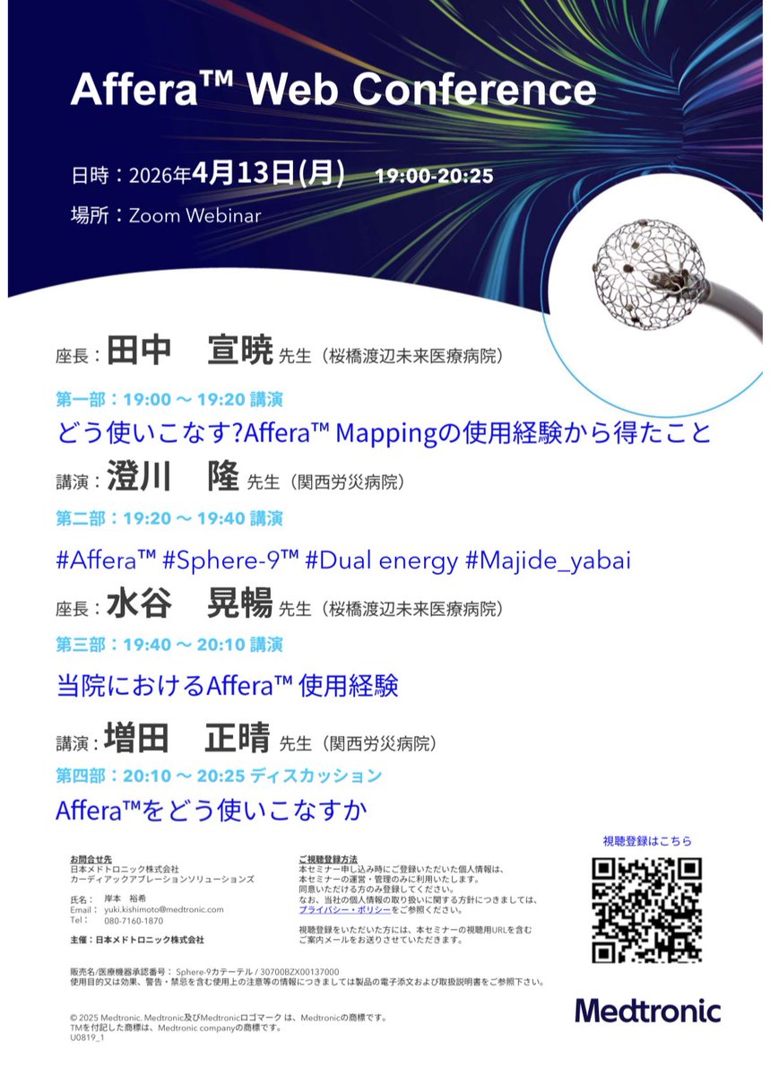
Affera Webinar 4/13 月曜日 19:00〜 たくさんの事前登録をいただいており、ありがとうございます🌈 ✅対極板4枚って干渉しないの? ✅どんなmapが描けるの? ✅落とし穴やそれに対するTipsは? あとは率直に使ってみた感想など、関労チームとともにディスカッションします⭐ #Affera #3Dmapping
✅桜橋渡辺未来医療病院 ✅Affera初回使用 ✅PVI-FPI:100% ✅Linear Ablation:100% 3D mappingの腕が試される、夢のある機械!? #Affera #Sphere9 #DualEnergy #Majide_yabai (ウェビナーやります👀) (Afferaのお話です) (ご興味ある方はぜひ)


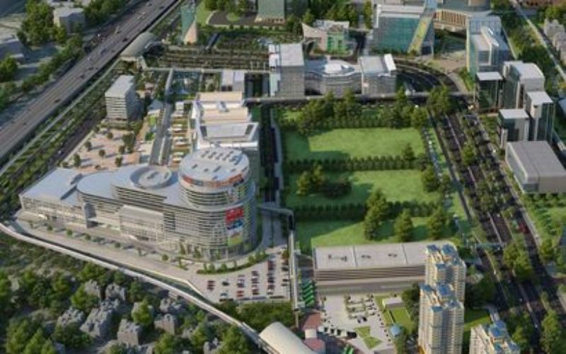
Virtualinfocom’s aerial 3D mapping helps architects visualise entire cities before construction begins. #3dmapping #urbanplanning #virtualinfocom

2024 brought major upgrades to #PIX4Dmatic, & we’re excited for what’s coming in 2025! ✨ In case you missed the 2024 highlights, now’s the time to catch up 🔍 — & stay tuned for what’s next ⏳👀 To the highlights: pix4d.com/blog/pix4dmati… #Photogrammetry #3Dmapping #geospatial


DJI Matrice 4E helps preserve cultural heritage through precision 3D modeling, capturing every detail of a historic Drum Tower for future generations. #djienterprise #djimatrice4e #3dmapping #culturalheritage
久々、AT mapping解析しきれなくて凹んでます。 最近ATなんて楽勝って天狗になってました👺 また精進します。 デバ研行きたかったな #3Dmapping #最近ATなめてました

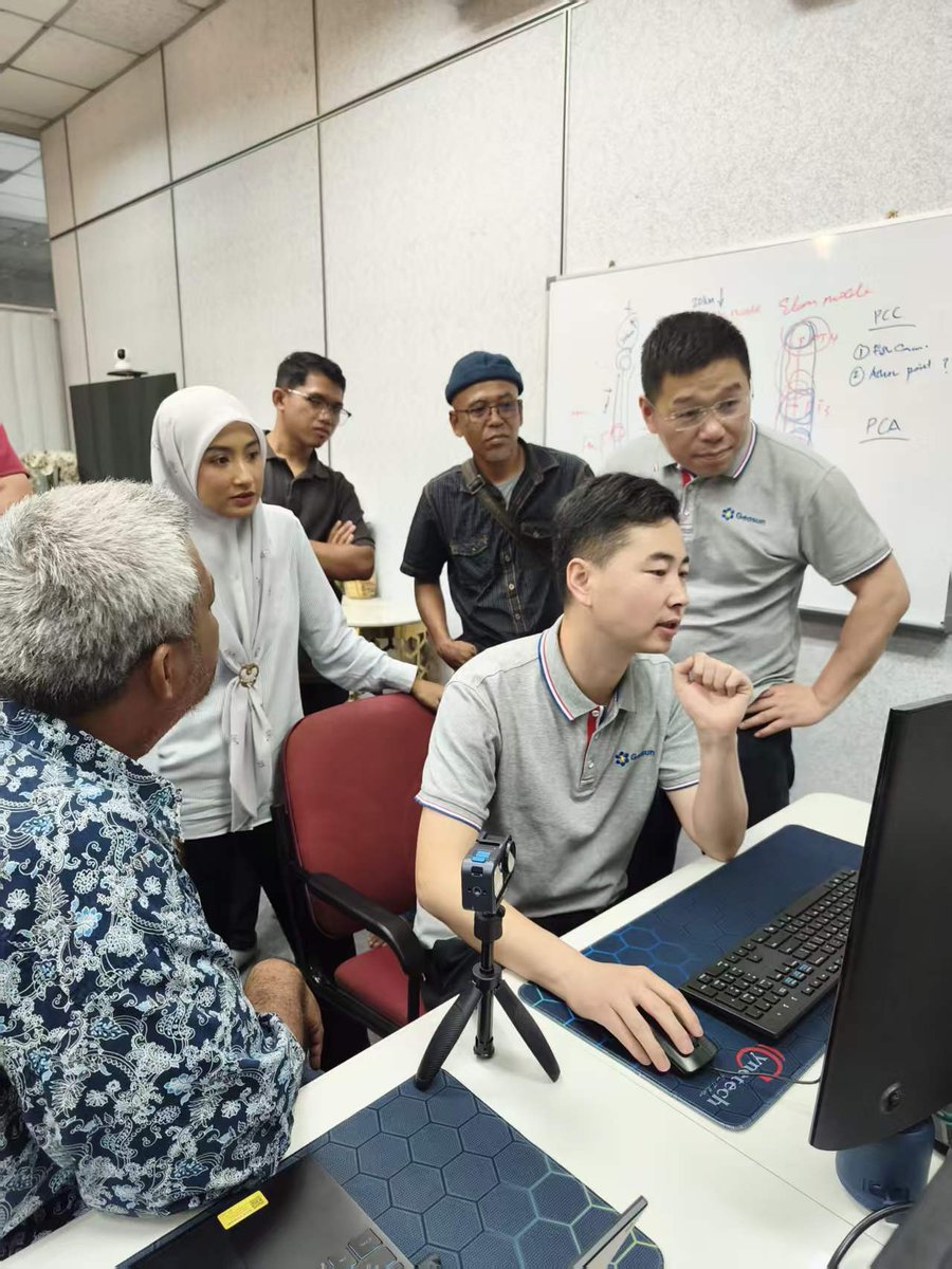
Not just traveling — we’re on-site. Singapore, Indonesia, Malaysia. Real clients. Real projects. Real LiDAR workflows. We don’t just deliver products. We make sure they work — in your project. #LiDAR #GeosunLiDAR #3DMapping #FieldWork #Surveying


Exciting news for 3D artists! 🎉 RizomUV 2024 has arrived with game-changing features like robust trimsheets, enhanced UI, and improved transform tools. Dive into a new world of possibilities with this upgrade! #RizomUV #3Dmapping #GameChanger #Innovation #Upgrade

@InertialLabs boosts geospatial workflows with PCMasterPro 1.16, delivering improved performance, accuracy, and efficiency in 3D terrain modeling. #3DMapping #LiDAR #Geospatial #powerelectronics #powermanagement #powersemiconductor @ViaviSolutions electronicsbuzz.in/inertial-labs-…


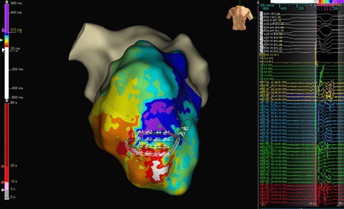
How does #3Dmapping system improve outcomes? Prof. @Phiso_de shares how FARAVIEW™ enables more accurate #PFA visualisation, supporting greater precision in clinical decision-making. #MedEd #MedTwitter

Where imagination meets technology: 3D mapping transforms spaces into breathtaking works of art, bringing creativity to life in every dimension! #Creativity #entourage #3dmapping #
In this interview, Dr @Mel_Gunawardene discusses the clinical benefits of using a #3Dmapping system and how FARAVIEW™ enhances the ability to visualise pulsed field ablations. Watch Now: bostonsci.co/gu5VMPEgqVb #Epeeps #MedEd

#WeekendRead 📚 Researchers at @oxfordrobots developed lightweight, handheld techniques capable of #3Dmapping entire buildings - in a matter of hours 🪄 Fundamental challenges in #robotics & autonomous technologies were tested in the @SheldonianOxUni 🎓 bit.ly/3CQ10jp
ox.ac.uk
Mapping the old with the new: handheld 3D scanning of Oxford's Sheldonian Theatre
A collaborative project involving the Oxford Robotics Institute, the Sheldonian theatre, and multinational construction equipment company Hilti is bringing forward the next generation of digital...

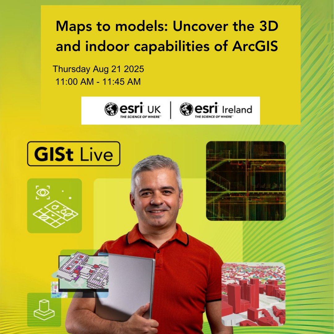
Join our webinar and discover how to transform 2D features into #3DMapping. Explore ArcGIS's indoor capabilities for operational efficiency. #SceneViewer #IndoorGIS Take your GIS skills to the next level! 📅 Thursday 21st August 2025 ⏰11:00 – 11:45 am ow.ly/piqZ50WHozC

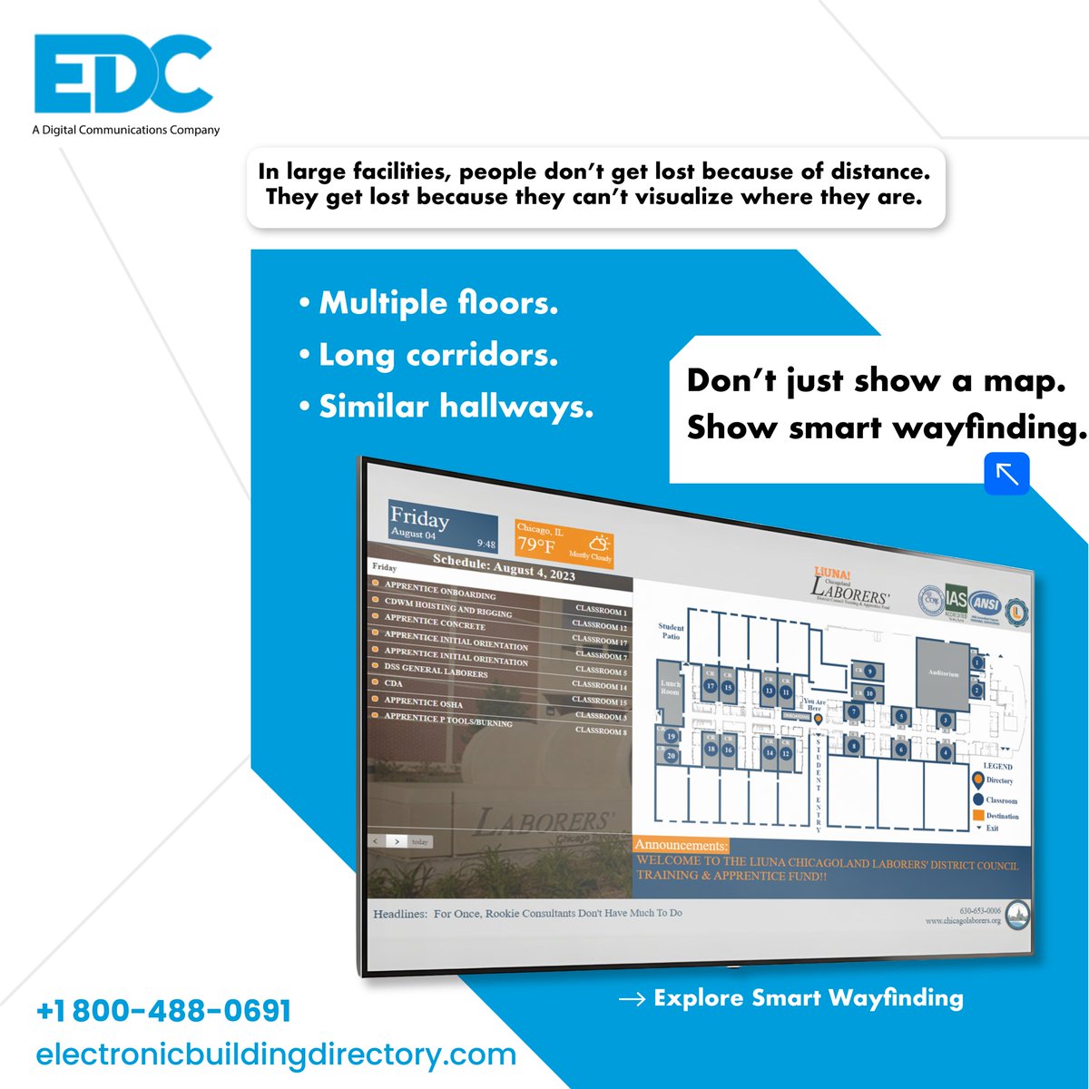
Getting lost isn’t about distance it’s about unclear spaces. digital wayfinding make navigation simple with interactive maps & smart directories. 👉Link in bio. #DigitalWayfinding #3DMapping #SmartBuildings #WayfindingSolutio
@InertialLabs boosts geospatial workflows with PCMasterPro 1.16, delivering improved performance, accuracy, and efficiency in 3D terrain modeling. #3DMapping #LiDAR #Geospatial #powerelectronics #powermanagement #powersemiconductor @ViaviSolutions electronicsbuzz.in/inertial-labs-…

@InertialLabs is taking 3D terrain modeling to the next level with the latest update of PCMasterPro 1.16, delivering enhanced accuracy and efficiency in LiDAR data processing. #LiDAR #3DMapping #Geospatial #Engineering #electronicsnews #technologynews timestech.in/inertial-labs-…

Not just traveling — we’re on-site. Singapore, Indonesia, Malaysia. Real clients. Real projects. Real LiDAR workflows. We don’t just deliver products. We make sure they work — in your project. #LiDAR #GeosunLiDAR #3DMapping #FieldWork #Surveying
Affera Webinar 4/13 月曜日 19:00〜 たくさんの事前登録をいただいており、ありがとうございます🌈 ✅対極板4枚って干渉しないの? ✅どんなmapが描けるの? ✅落とし穴やそれに対するTipsは? あとは率直に使ってみた感想など、関労チームとともにディスカッションします⭐ #Affera #3Dmapping
✅桜橋渡辺未来医療病院 ✅Affera初回使用 ✅PVI-FPI:100% ✅Linear Ablation:100% 3D mappingの腕が試される、夢のある機械!? #Affera #Sphere9 #DualEnergy #Majide_yabai (ウェビナーやります👀) (Afferaのお話です) (ご興味ある方はぜひ)

Artec 3D has launched Artec Jet, a new SLAM‑based LiDAR system designed to deliver high‑precision 3D mapping technology at scale. eurekamagazine.co.uk/content/news/a… #3DMapping #LiDARTechnology #Artec3D

Artec 3D Launches Artec Jet SLAM-based Mobile LiDAR Scanner dailycadcam.com/artec-3d-launc… via @dailycadcam @Artec3DScanners #ArtecJet #3DLiDARScanner #3DMapping #Drones #Photogrammetry #ProjectionMapping #SpatialData #Surveying #Geosystems #GIS


KV-Tracker reconstructs 3D scenes in real-time at 30 FPS using a single RGB camera—no depth sensors or retraining required. 🤖📍 #Robotics #ComputerVision #3DMapping
Everyone sells handheld LiDAR Everyone talks airborne mapping. What if one system could do BOTH? ✈️ Compact enough for your suitcase, powerful enough for 300m mapping — no switching devices, no workflow breaks. Curious? We’ll bring the demo to your site. #3DMapping #Surveying


Confined. Hazardous. Inaccessible. Now fully measurable. GEOSUN brings high-precision 3D mapping to where humans can’t go. #LiDAR #3DMapping #SLAM #Geospatial #Robotics #QuadrupedRobot #DigitalTwin #Surveying #SmartMapping #Inspection #GeoSpatialIntelligence #PointCloud

Late potentials and Iscohronal Crowding are predictive of VT isthmus sites – but in this case, they were not part of the VT isthmus site. Is ILAM mapping really the future? Read more 👉 lttr.ai/ApTJv #epeeps #3dMapping #ecg
Just landed in Singapore — and straight to work. Started our first on-site demo right away, and as always, impressed by how clean and well-organized the city is. Looking forward to more demos and great conversations ahead. #GeosunLiDAR #LiDAR #3DMapping #Surveying


Y hasta aquí el macizo bético. 🏔️ Si os mola ver cómo transformamos datos topográficos en arte, seguidnos también por Instagram y TikTok (links abajo) 📱. Si quieres tu montaña o ruta favorita en 3D, ¡tíranos un MD! 📩 ¿Cuál debería ser la siguiente cumbre? Os leemos 👇#3DMapping

रास्ता ढूंढना अब होगा और भी आसान! गूगल ने मैप्स में जोड़ा 3D विजुअल अपडेट। अब फ्लाईओवर से लेकर बिल्डिंग तक, सब कुछ दिखेगा एकदम रियल। टाइप करने की जरूरत नहीं, बस मैप खोलो और दुनिया को नए नज़रिए से देखो। देखिए यह टेक अपडेट। #GoogleMaps #TechUpdate #3DMapping #GoogleNews

Learn how network storage solutions and NAS systems support high-resolution archaeological mapping and 3D terrain reconstruction with scalable, secure, and high-performance data storage. #NASSystems #ArchaeologyTech #3DMapping #GeospatialData nasstorage.webador.co.uk/blog/3061951_n…

Visiting different client sites and collecting real project data with our LiDAR systems. Always great to see the technology working directly in the field. #LiDAR #GeosunLiDAR #3DMapping #Surveying #Vietnam #Hanoi #FieldWork #PointCloud


✨ Last day at #INTERGEO2025 — what an amazing experience! Still time to drop by and discover our latest 3D mapping innovations 🚀 📍 Booth D135 | Hall 12.0 #Gexcel #3DMapping #GeospatialInnovation #DigitalTwins


The ultimate coaching tool: Camera Events re-created on a 3D map.📍#AI #Geospatial #3DMapping #Innovation #DigitalTwin #TechForGood #LiveStream #TrendingNow #ReelsRevolution #DriverSafety

See the world in 3D with SLAM100 🌍 360° capture, panoramic vision, and vibrant point cloud results — all in the palm of your hand ✨ From streets to structures, mapping has never been this effortless. #SLAM100 #3DMapping #LiDAR #PointCloud #3DScanning #TechInnovation

🚀 LiDAR Professional Training – Master 3D Mapping & Surveying Skills! 🌍 👉 Enroll now: lctss.in/lidar-professi… #LiDAR #Surveying #3DMapping #Lctss #SurveyTraining #GIS #LandSurvey #ProfessionalSkills ✨


#highlycitedpaper Proposing UGV and UAV Systems for 3D Mapping of Orchard Environments mdpi.com/1424-8220/22/4… @unito #SmartAgriculture #3DMapping #PointClouds

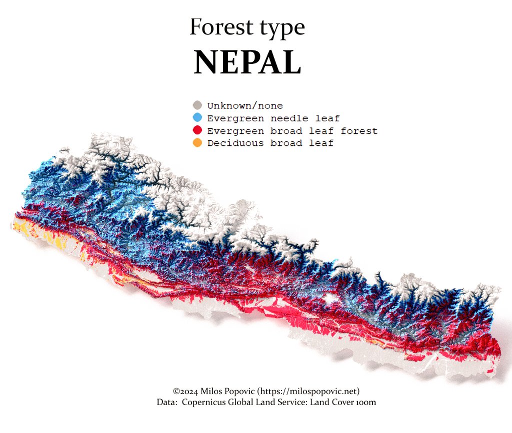
Take a look at Nepal's🇳🇵 forest types from a new perspective with my 3D map. For those interested in GIS and environmental science, I've put together a tutorial on how to create these maps. Access it here: youtu.be/MFbJrjpf_2M #3DMapping #GIS #Nepal #Forest #Environment

🇩🇪🔥 Germany like you’ve NEVER seen it before! This 3D forest map is a literal texture party for the eyes 🌲🎉....Needleleaf, broadleaf, and pure MAGIC... Ready to dive into this surreal adventure? #RArt #3DMapping #GermanyForests #Dataviz #30DayMapChallenge


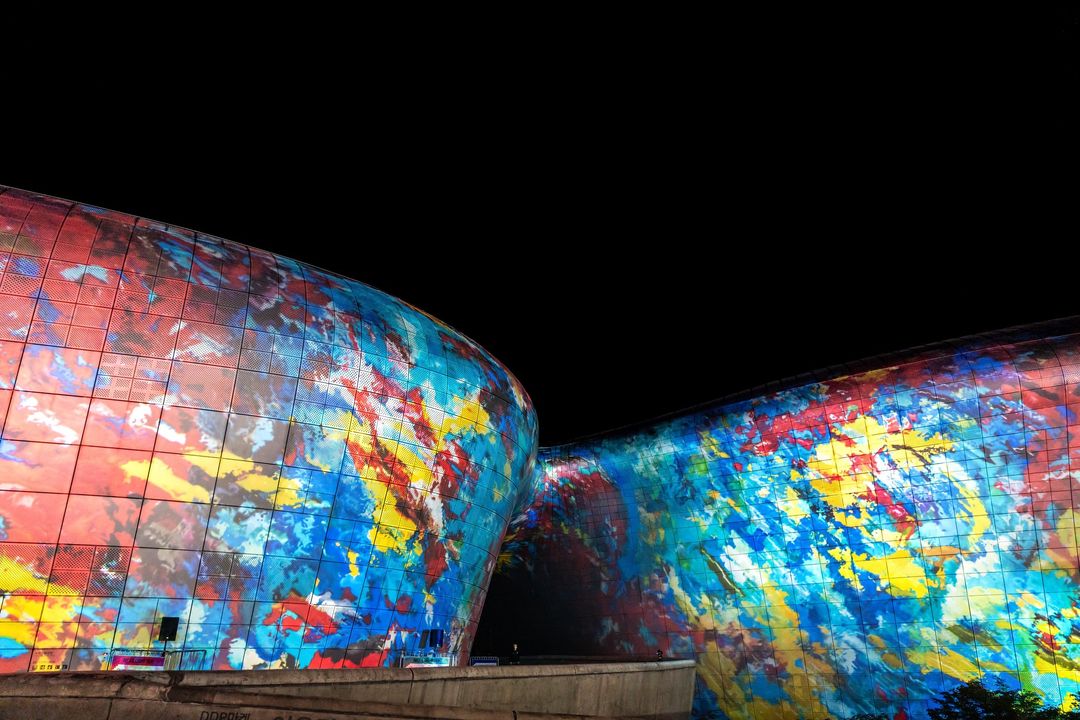
Check out Screenberry in action at the Seoul Light DDP 2024 Autumn Festival. Our media server runs and aligns 26 @Barco projectors to create a projection mapping show on the Dongdaemun Design Plaza building in downtown Seoul. Photos: @Seoul_DDP #3DMapping #ProjectionMapping


Excited about 3D mapping? 🌍Check out this LIDAR PointCloud project! Integrate a LIDAR sensor & stepper motor to scan & visualize spatial data. Perfect for robotics & more! 🤖For more details: instructables.com/LIDAR-PointClo… #DIY #3DMapping #LiDAR
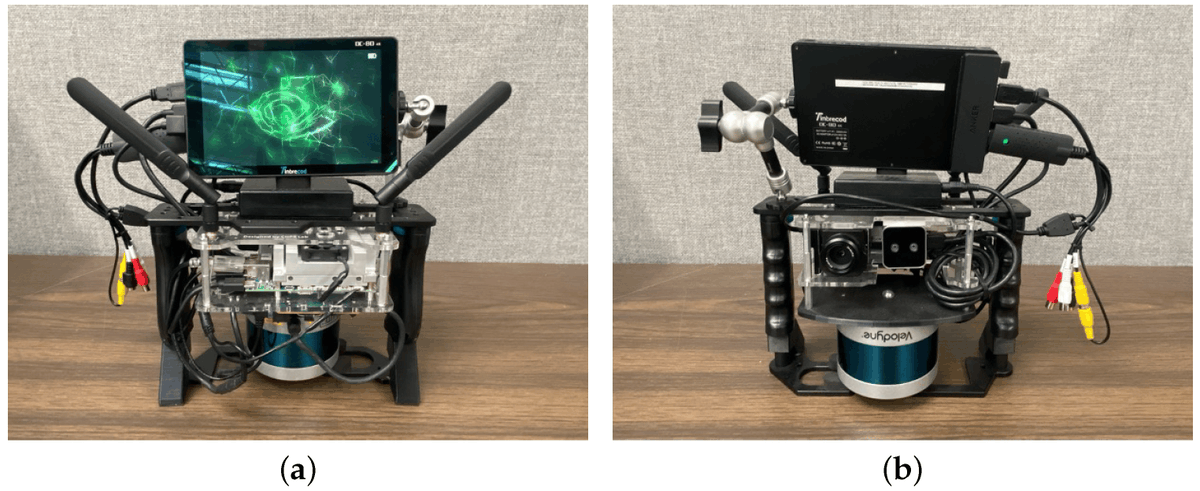
A Compact Handheld Sensor Package with Sensor Fusion for Comprehensive and Robust 3D Mapping mdpi.com/1424-8220/24/8… @UofCalifornia #3Dmapping; #sensorfusion; #SLAM
Join our webinar and discover how to transform 2D features into #3DMapping. Explore ArcGIS's indoor capabilities for operational efficiency. #SceneViewer #IndoorGIS Take your GIS skills to the next level! 📅 Thursday 21st August 2025 ⏰11:00 – 11:45 am ow.ly/piqZ50WHozC
Every dataset hides a landscape. Give it height & light, and it speaks. I packed that magic into 30 video tutorials on 3D rendering: one project per video ⤵️ youtube.com/playlist?list=… Dive in, share your dream map below! 👇 #GIS #3DMapping #DataViz #Cartography #OpenSource

🚀 @Genesysmaps secures ₹15 Cr to supercharge its #3Dmapping expansion around #Pune! This strategic boost strengthens India's #geospatial infrastructure and supports smarter #urbanplanning through advanced #digitalmapping. #GIS #GeoNews #UrbanInnovation bit.ly/3GwK6Lm

🚀 Esri + Pix4D: nuovo workflow per mappatura terrestre in tempo reale. Con PIX4Dcatch i dati raccolti sul campo diventano modelli 3D e AR integrati subito in ArcGIS Online. #Esri #GIS #3DMapping #Geospatial #ArcGIS @pix4d

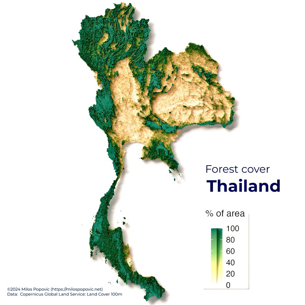
Happy to share my 3D map of Thailand’s forest cover from 2019. Over 16 million hectares of forest, covering 30% of the land! Want to create your own? Check out my tutorial: lnkd.in/eAUfHjbw #DataViz #3DMapping #Rstats #GIS #SpatialAnalysis #Geospatial #DataScience
Coming in July! 📘 𝘔𝘢𝘱𝘱𝘪𝘯𝘨 𝘸𝘪𝘵𝘩 𝘈𝘭𝘵𝘪𝘵𝘶𝘥𝘦: 𝘋𝘦𝘴𝘪𝘨𝘯𝘪𝘯𝘨 3𝘋 𝘔𝘢𝘱𝘴 by @NathanCShephard explores concepts, challenges, and opportunities in 3D cartography using easy-to-follow workflows. esri.social/aXuA50S95Fb #3DMapping #Cartography

🌐 Research report from @theAREAorg: "#3Dmapping of Enterprise and Industrial Environments for #AugmentedReality." 🌐 This executive summary provides an overview of 3D mapping principles, and defines parameters for choosing a #3Dscanner. Download: bit.ly/43LwvG5

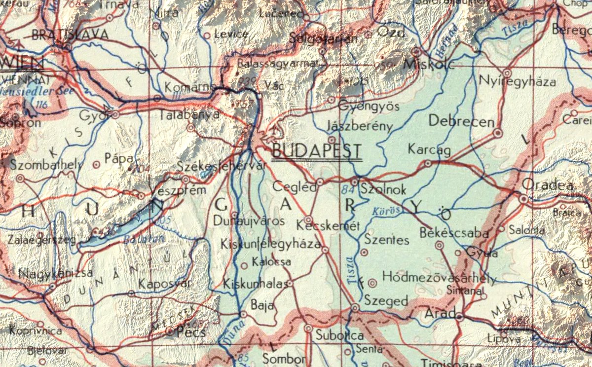
🗺️✨ Turning history into art! I transformed vintage 1967 maps of Switzerland 🇨🇭 & Hungary 🇭🇺 into stunning 3D visualizations. Topography meets technology bringing the past to life in a whole new dimension! 🌍 #RGeek #3DMapping #Cartography #VintageMaps

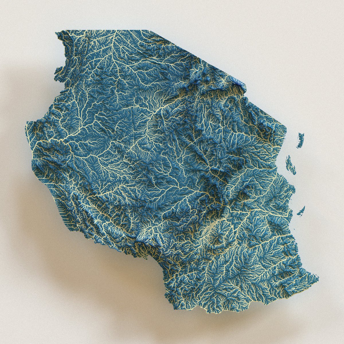
✨ Just dropped: Tanzania's 🇹🇿 veins of life in 3D! 🌊 Rivers flowing like circuits, carved in a stunning digital landscape. 🏞️ Zoom in, soak it up, and feel the hydrological vibe! 🛠️ Made with mad map love! 🗺️🔥👇 #Tanzania #Rivers #3DMapping #GIS #Africa #R #Dataviz #Hydro
2100+ views 🔥 UAV 3D mapping accuracy secret cracked! GCP reliability sets accuracy ceiling—high RMSE (0.1m)? Prioritize quantity 📏; low (5m+)? Edge+center distribution 🌍. Errors spike in rough terrain! #UAVPhotogrammetry #GCPHacks #3DMapping #GISTrends #DroneTech

🚨 Master Catheter Ablation Success 3D mapping systems are transforming catheter ablation with improved precision and success rates. 🔎 Explore the insights: touchcardio.com/your-free-10-m… #CatheterAblation #3DMapping #MedicalInnovation


As a architect, I've always been passionate about pushing boundaries and exploring new horizons within my field. However, recently, I've found myself venturing into uncharted territory - the world of drones and their applications in surveying. #DronesInConstruction #3DMapping


One of my favorite activities when working with communities is to help them map their ecosystem. It brings clarity and insights as they look at their maps from different cardinal points and perspectives. It is also fun! #3Dmapping #theoryu #community #facilitation #OppidHum
Something went wrong.
Something went wrong.
United States Trends
- 1. #WrestleMania N/A
- 2. Luke Kennard N/A
- 3. Bengals N/A
- 4. Lakers N/A
- 5. #LakeShow N/A
- 6. Rockets N/A
- 7. Porter Martone N/A
- 8. Sengun N/A
- 9. Giants N/A
- 10. Dexter Lawrence N/A
- 11. #IgniteTheOrange N/A
- 12. Orton N/A
- 13. Pat McAfee N/A
- 14. Bianca N/A
- 15. Flyers N/A
- 16. #UFCWinnipeg N/A
- 17. Paige N/A
- 18. Ayton N/A
- 19. Crosby N/A
- 20. #TAEMCHELLA N/A