Joint Polar Satellite System (JPSS)
@JPSSProgram
Official account of the Joint Polar Satellite System (JPSS). A collaborative @NOAA and @NASA program for latest generation of polar-orbiting weather satellites.
คุณอาจชื่นชอบ


Find out what it would be like to see @NOAA's JPSS or GOES satellites in your living room, or at the @NASA Goddard Visitor Center, with NOAA & @NASA's newest AR app! 📱 🛰️ Download here: bit.ly/3JrTRt4
As the Atlantic hurricane season wraps up, this #NOAA21 view from Oct. 28, 2025, shows Hurricane #Melissa over Jamaica in brightness-temperature imagery revealing its structure and intensity. Read more and watch the latest #EarthFromOrbit video: noaa.gov/news-release/2…


.@NOAA has released its initial review of the 2025 Atlantic #HurricaneSeason! Check out the season from NOAA’s #satellite perspective with our #EarthFromOrbit WATCH HERE: youtu.be/1uWNZH8vzHg
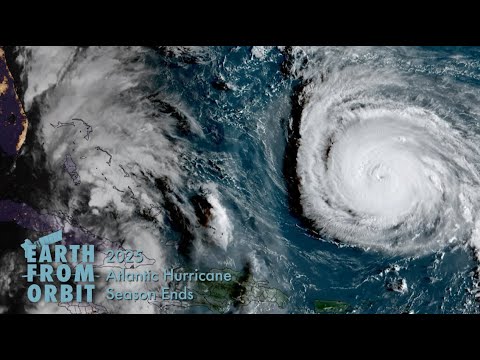
youtube.com
YouTube
2025 Atlantic Hurricane Season Wrap Up

JUST IN: The 2025 Atlantic #HurricaneSeason ends on Nov. 30 with 13 named storms, including 5 hurricanes, of which 4 intensified to be major hurricanes. Find our news release, images and wrapup video at: noaa.gov/news-release/2… @NWS

On Nov. 19, 2025, @NOAA’s JPSS satellites observed streaks of lake-effect snow, shown in cyan through color-enhanced imagery, on both sides of Lake Erie slowly melting over the course of the day. ❄️ Credit: NOAA/@CIRA_CSU
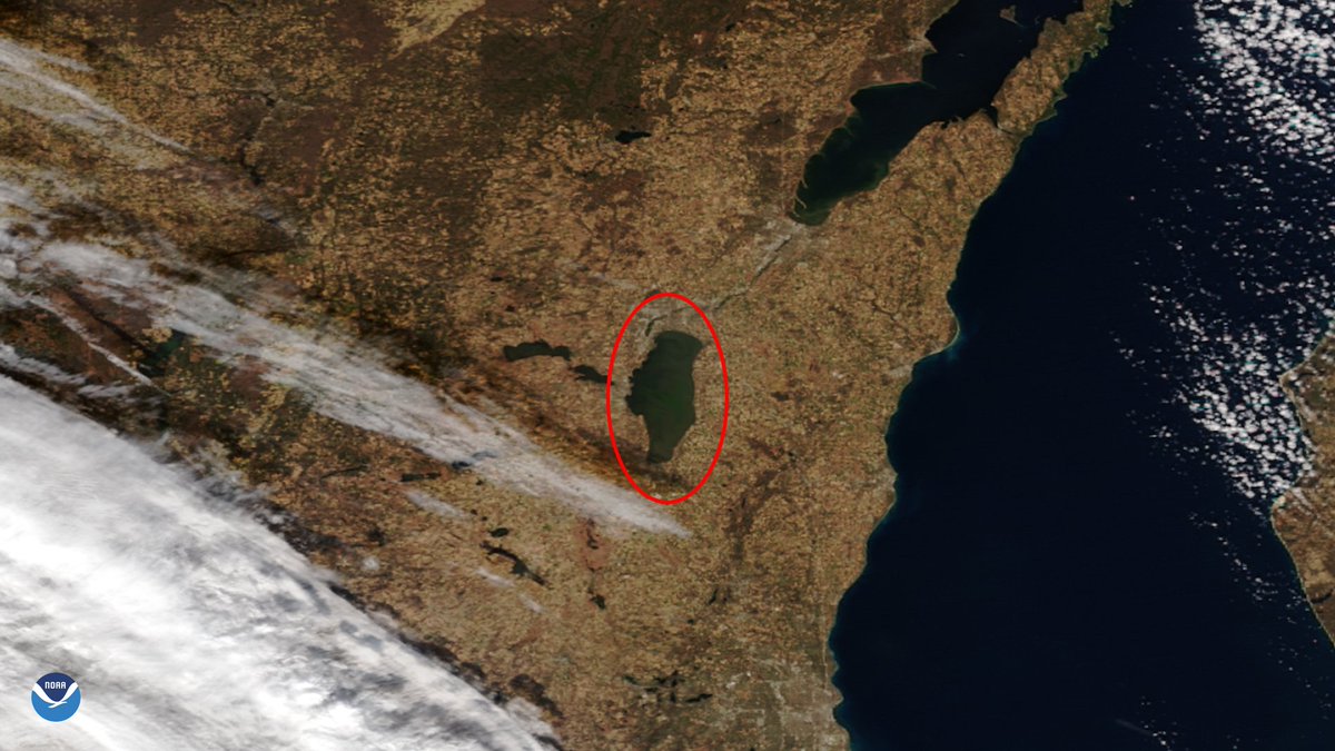
It's #WhereInTheWorld Wednesday! 🎉 Today we are featuring this lake that was captured by our #NOAA21 🛰️ as it passed overhead on Nov. 17, 2025. It is the remnants of an ancient glacial lake and the largest lake located entirely in Wisconsin. It is also a popular fishing spot…

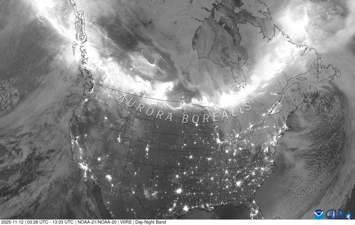
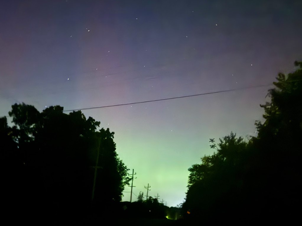
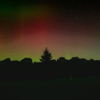
We're back, and so are the #NorthernLights! 🌌 @NOAA's @JPSSprogram polar-orbiting satellites captured this dazzling #aurora composite imagery of North America from Nov. 11-12. Did you see them from the ground? If so, we'd love to see your photos! 📸
The U.S. Government is closed & this account will not be updated. @NOAA websites & social media necessary to protect lives & property WILL be maintained. For critical weather information from NOAA's @NWS, please visit weather.gov. Learn more:…

From the fastest-forming Category-5 to the most intense #hurricane ever recorded, @NOAA #satellites have seen it all. 🌀 As this year’s #HurricaneSeason continues, discover how our eyes in the sky track record-breaking storms to provide critical data and help communities…

Smoke from ongoing wildfires in the Pacific NW pushed daily-average PM2.5 air quality above the US health standard on 28 Sep in northern ID, southwestern OR & central-northern WA, per @AIRNow regulatory monitors & estimated by VIIRS on @JPSSProgram satellites. @NOAASatellites

Thick smoke (purple shading) from wildfires in Washington State blew northward into British Columbia, Canada yesterday 23 Sep, observed by the @JPSSProgram VIIRS sensor on @NOAASatellites NOAA-21.

Yesterday marked the #AutumnEquinox. See how greenery across the United States changed from June through mid-September 2025, as the seasons shift from summer to fall. 🌳🍂
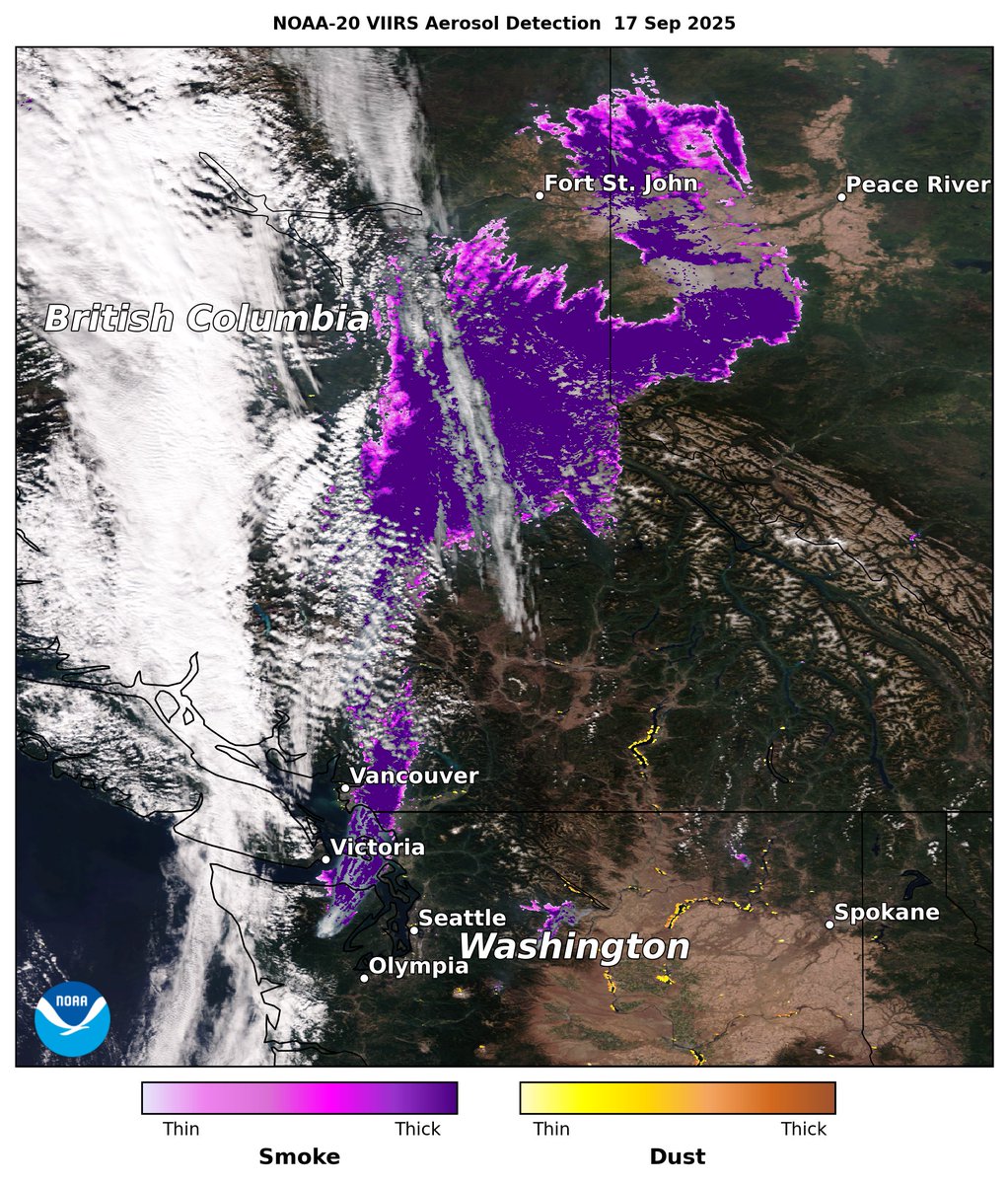
Wildfire smoke from British Columbia, Canada, is seen in this observation from the #VIIRS instrument onboard the #NOAA20 satellite on Sept. 17, 2025. Several fires are highlighted as red dots, with smoke drifting northeast across the northwestern U.S. and southwestern Canada.

Wildfires in northwestern Washington State and southern British Columbia emitted thick smoke (purple shading) that reached into western Alberta yesterday 17 Sep, detected by the @JPSSProgram VIIRS sensor on @NOAASatellites NOAA-20. @Karma_lobsang12
As they passed over North America, @NOAA's @JPSSProgram satellites captured the brilliance of the #NorthernLights on Sept. 14-15. Learn more: bit.ly/46sWZQd #AuroraBorealis


The @JPSSProgram VIIRS sensor on @NOAASatellites NOAA-21 detected a plume of thick Saharan dust (brown shading) blowing off the coast of West Africa & over the Atlantic Ocean yesterday 16 Sep. @Karma_lobsang12

It's #WhereInTheWorld Wednesday! 🎉 Yesterday, the #NOAA21 🛰️ captured a clear view of a broad, tan-colored river basin in the Pacific Northwest.

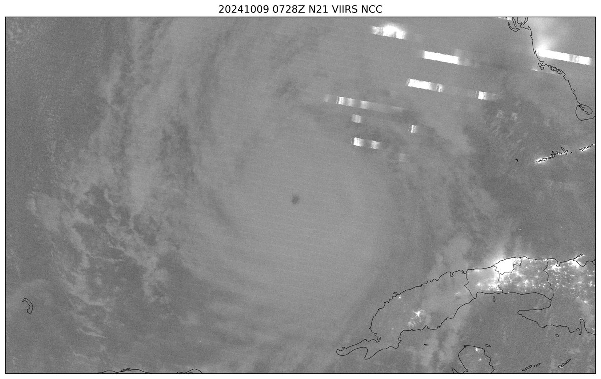
This #NOAA21 satellite view from Oct. 9, 2024 shows Hurricane Milton near Cuba. Twenty years after Hurricane Katrina, JPSS instruments represent significant advancements, providing forecasters with critical data to track and predict storms. More in this #EarthFromOrbit video:…
Twenty years ago, @NOAA satellites helped monitor and track one of the deadliest hurricanes in U.S. history—#HurricaneKatrina—as it devastated New Orleans and the Mississippi coast. Today, NOAA's latest generation of satellites provide faster and more accurate forecasts and…
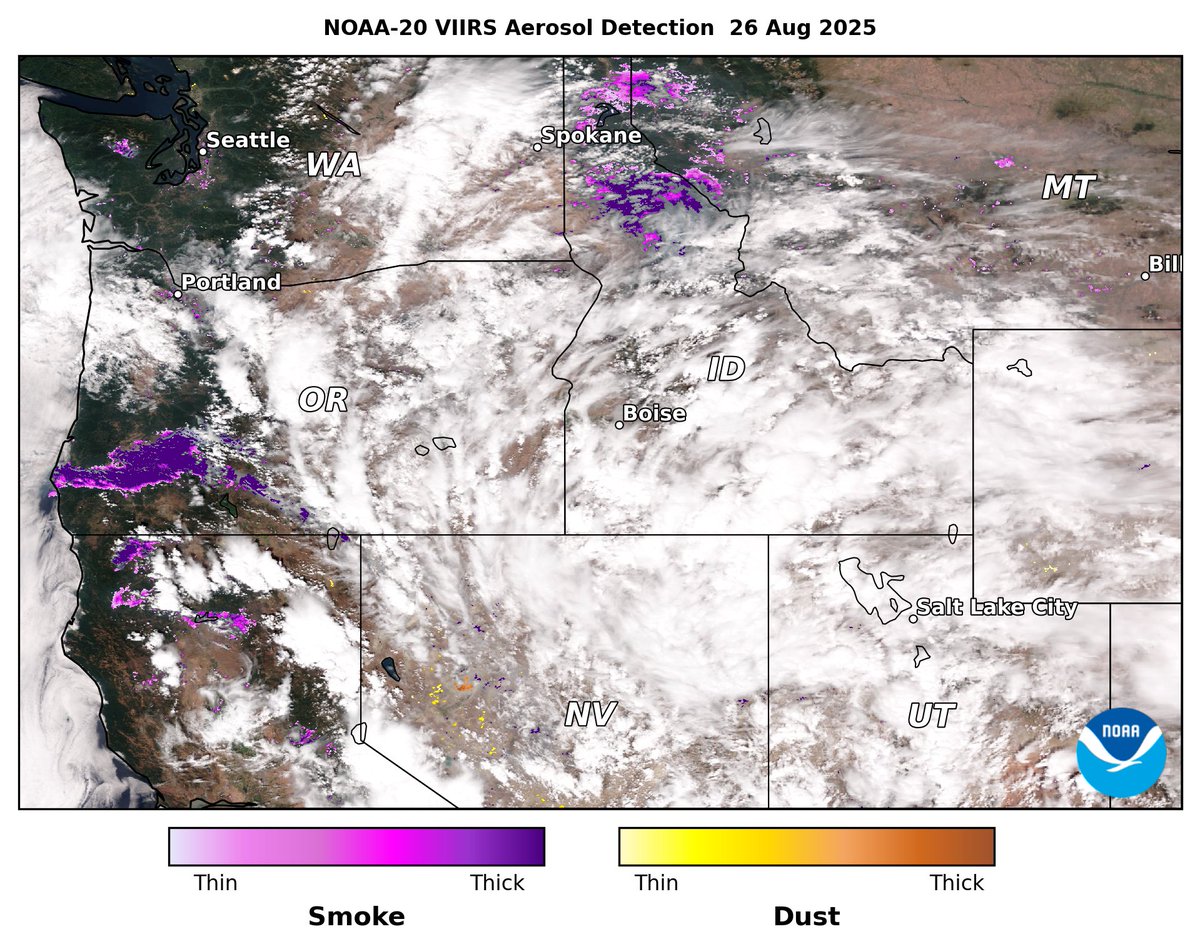
Numerous wildfires in the western US continued burning on 26 Aug, observed by @JPSSProgram VIIRS on @NOAASatellites NOAA-20. Fire radiative power (FRP, Left) shows the fires' location & intensity, and aerosol detection (Right) indicates the fires released thick smoke (purple).

It's #WhereInTheWorld Wednesday! On August 11, 2025, #NOAA21 captured this sapphire of a freshwater lake, known as the "Caribbean of the Rockies" due to its unique color caused by limestone deposits. It's over 250,000 years old and formed by tectonic activity.


United States เทรนด์
- 1. Penn State 20K posts
- 2. #twitchrecap 13K posts
- 3. #TADCFriend 1,755 posts
- 4. Paul Dano 1,415 posts
- 5. Slay 20.4K posts
- 6. Pat Kraft 2,364 posts
- 7. Romero 23.6K posts
- 8. Zion 10.1K posts
- 9. Tarantino 8,262 posts
- 10. #LightningStrikes N/A
- 11. #GivingTuesday 32.3K posts
- 12. Bernie 25.7K posts
- 13. Somali 175K posts
- 14. Fulham 46.2K posts
- 15. Sleepy Don 6,408 posts
- 16. Franklin 68.9K posts
- 17. Larry 64.2K posts
- 18. Sabrina Carpenter 44.6K posts
- 19. Cody Ponce N/A
- 20. Trump Accounts 31.5K posts


Something went wrong.
Something went wrong.