NWS Climate Prediction Center
@NWSCPC
Official X account for the National Weather Service Climate Prediction Center. Details: http://weather.gov/nws_x
Vous pourriez aimer


La Niña conditions are present and favored to persist through December 2025-February 2026, with a transition to #ENSO-neutral most likely in January-March 2026 (55% chance). A #LaNina Advisory is now in effect. cpc.ncep.noaa.gov/products/analy…

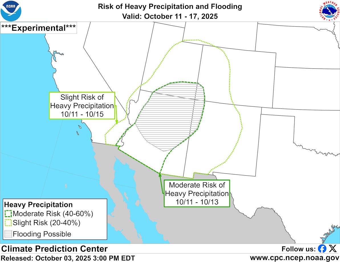
Heavy precipitation is forecast for the Southwest late next week, as moisture from one or two potential tropical cyclones moves into the region from the Eastern Pacific. In areas of recent burn scars or in elevated terrain, flash flooding may result. cpc.ncep.noaa.gov
The start of the wet season across the Pacific Northwest is predicted to begin by next week. Chances of 50-60% above-normal precipitation are predicted for the region during week-2, with 60-70% across coastal Washington and Oregon.

A transition from #ENSO-neutral to La Niña is likely in the next couple of months, with a 71% chance of La Niña during Oct-Dec 2025. Thereafter, La Niña is favored but chances decrease to 54% in Dec 2025-Feb 2026. A #LaNina Watch remains in effect. cpc.ncep.noaa.gov/products/analy…

Rapid onset drought possible across much of the OH, TN, and MS Valleys during mid-late Sep. Less than 25% of normal rainfall has fallen during the past 30 days for much of the region. Below normal precipitation and above normal temperatures are favored for much of the area.

A pattern change to warmer than normal temperatures is predicted for the central U.S. during week-2.

ENSO-neutral is most likely through late Northern Hemisphere summer 2025 (56% chance in Aug-Oct). Thereafter, a brief period of La Niña conditions is favored in fall and early winter 2025-26 before reverting to #ENSO-neutral. A #LaNina Watch is in effect. cpc.ncep.noaa.gov/products/analy…


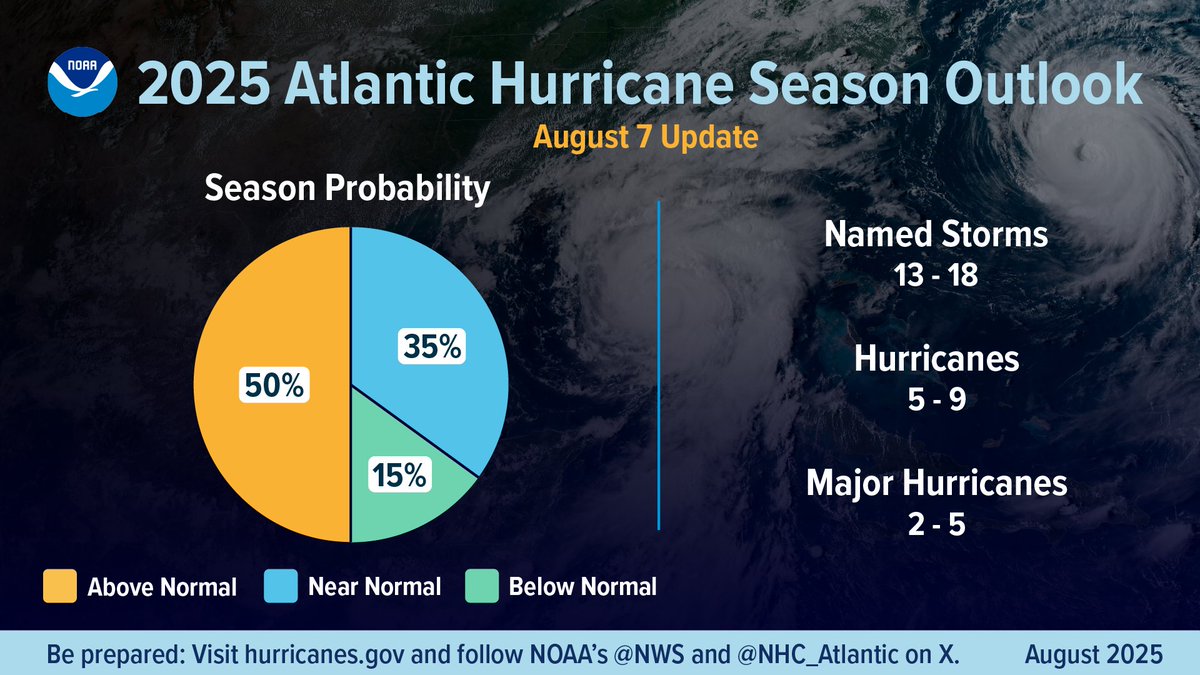
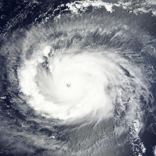
NOAA urges both coastal and inland communities to prepare for severe weather as we approach the historical peak of #HurricaneSeason Our August 7 update: bit.ly/AtlanticHurric… @NWS @NWSCPC

The August 7 update to NOAA's 2025 Atlantic Hurricane Season Outlook calls for: 13-18 named storms, 5-9 hurricanes & 2-5 major hurricanes. Our prediction for an 'above-normal' season remains on track. PREPARE NOW. --> See our news release + downloadable infographics at:…

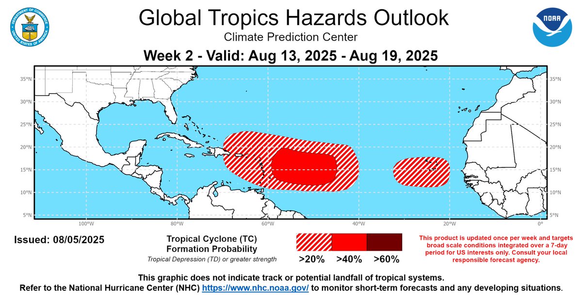
Chances for Atlantic tropical cyclone formation normally rise in August, and this year is no different! Formation chances are currently forecast to increase for the Central Atlantic through mid-August. Get the latest on any tropical development at hurricanes.gov.
After a mild start to August across the Northeast, temperatures are forecast to warm to above-normal by the second week of the month. From August 12 to 18, there is a 70 to 80 percent chance of above-normal temperatures with daily highs in the mid 80s to around 90 F.

🌡️ Here are the latest key messages regarding the heat building across the Southwest later next week into the following week.

Risk of extreme heat for much of the central and southwestern United States, visit cpc.ncep.noaa.gov for more information.

Hot weather possible in the Southern Plains and Southwest late next week. A moderate risk of extreme heat is posted in the Sonoran Desert, where highs may exceed 115 degrees F. The risk declines after August 9, but a slight risk persists until August 13 in the Southwest.

After dangerous late July extreme heat, significant relief is likely in early August across much of the Southeast due to a strong cold front. Heavy rains and localized flooding are possible along this cold front next weekend. wpc.ncep.noaa.gov/key_messages/L… cpc.ncep.noaa.gov/products/predi…


Over 90 million people are under heat alerts currently (Extreme Heat Warnings, Watches, and Heat Advisories). The heat is expected to persist the longest over the Mid-MS Valley and Mid-South regions this week. Here are the latest Key Messages.
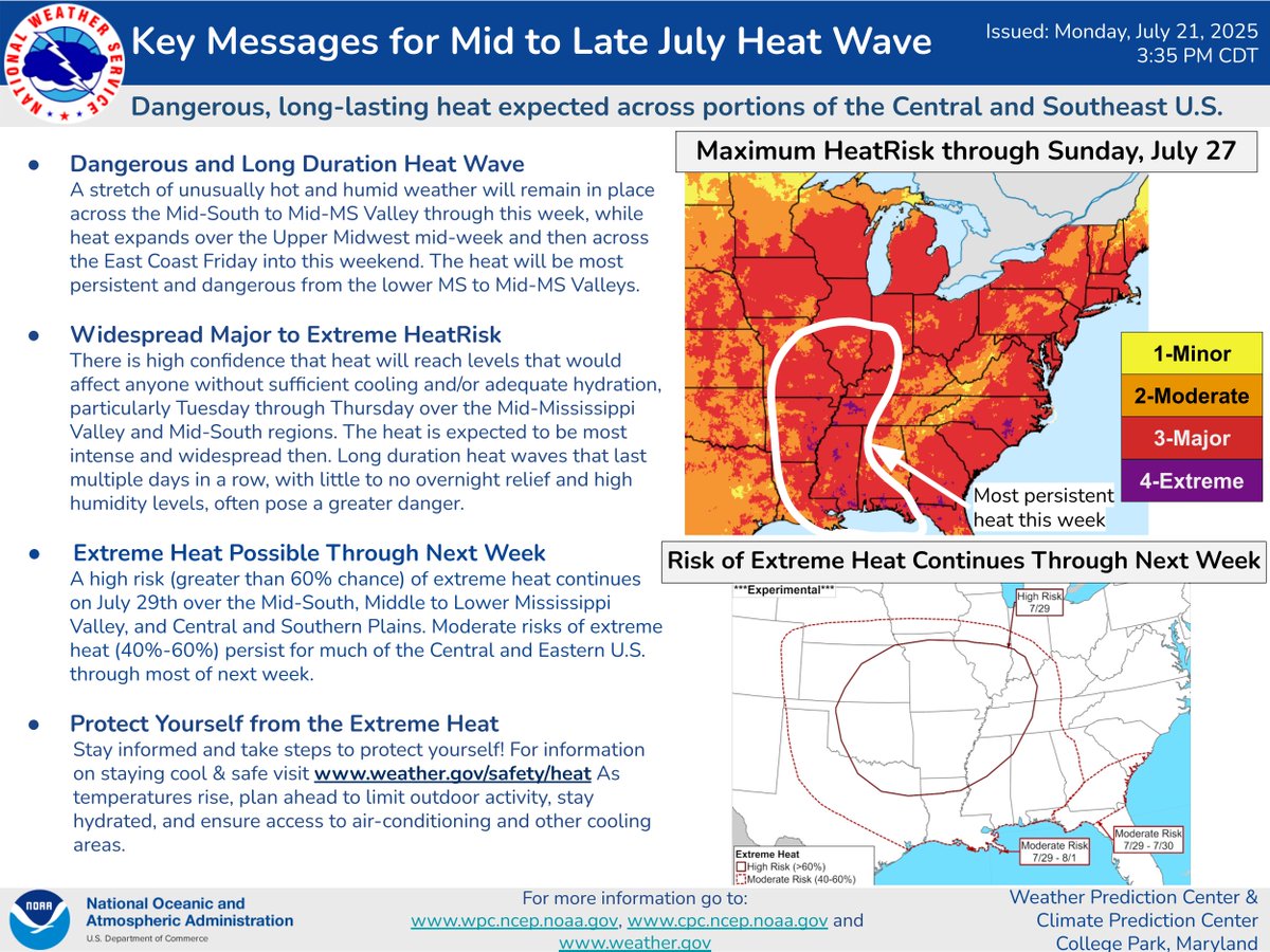
Heat is forecast to build and spread across parts of the central U.S. and Southeast from this weekend into next week. Below are the WPC/CPC Key Messages highlighting the upcoming heat wave.

ENSO-neutral is most likely through the late Northern Hemisphere summer 2025 (56% chance in August-October). Thereafter, chances of #LaNina conditions increase into the fall and winter 2025-26, but remain comparable to #ENSO-neutral. cpc.ncep.noaa.gov/products/analy…

Hotter temperatures possible for the Western U.S. late next week, with highs potentially reaching over 110 degrees F for the Desert Southwest, and over 100 degrees F for the Central Valley of CA. Highs between 90 and the low 100’s are possible for areas within the Slight Risk.

Increased risk of heavy rainfall for much of the Desert Southwest with localized flooding possible. Visit cpc.ncep.noaa.gov for more information.


United States Tendances
- 1. Good Sunday 53.8K posts
- 2. #AskBetr N/A
- 3. #sundayvibes 4,724 posts
- 4. Discussing Web3 N/A
- 5. #HealingFromMozambique 20.4K posts
- 6. Miary Zo 1,171 posts
- 7. Trump's FBI 12.1K posts
- 8. Wordle 1,576 X N/A
- 9. KenPom N/A
- 10. Coco 48.5K posts
- 11. Biden FBI 18.7K posts
- 12. Blessed Sunday 17.6K posts
- 13. #ChicagoMarathon N/A
- 14. Mason Taylor N/A
- 15. The CDC 32.8K posts
- 16. Gilligan 7,175 posts
- 17. Lord's Day 1,674 posts
- 18. Macrohard 9,799 posts
- 19. Go Broncos 1,318 posts
- 20. AM READY 16.4K posts
Vous pourriez aimer
-
 NWS Weather Prediction Center
@NWSWPC -
 NOAA Aircraft Operations Center
@NOAA_HurrHunter -
 NWS Storm Prediction Center
@NWSSPC -
 NOAA National Severe Storms Laboratory
@NOAANSSL -
 National Hurricane Center
@NWSNHC -
 NWS Southern Region
@NWSSouthern -
 NWS LMRFC
@NWSLMRFC -
 NOAA Communications
@NOAAComms -
 NWS Severe Tstorm
@NWSSevereTstorm -
 NWS OHRFC
@NWSOHRFC -
 NOAA Research
@NOAAResearch -
 NWS Eastern Region
@NWSEastern -
 American Meteorological Society
@ametsoc -
 National Weather Association
@nwas -
 NOAA NCEI
@NOAANCEI
Something went wrong.
Something went wrong.