
你可能會喜歡


Good morning, #FloridaKeys! A Coastal Flood Advisory remains in effect for the Upper Keys through early Monday morning. For the Lower and Middle Keys, a Coastal Flood Statement is now in effect through early Monday morning. #FlKeys #Flwx #KeyLargo #MarathonFL #KeyWest

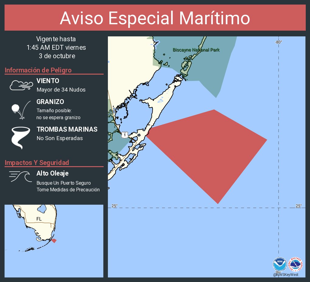
Aviso Especial Marítimo incluye Aguas del Golfo desde el Este de Cabo Sable a Chokoloskee 20 a 60 MN hacia afuera y pasando 5 Fathoms hasta las 3:30 AM EDT

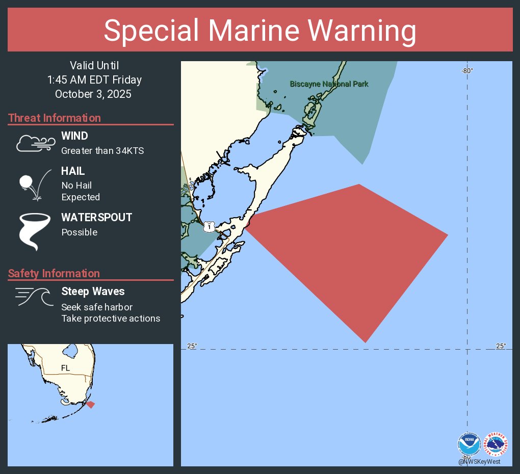
Special Marine Warning including the Gulf of America from East Cape Sable to Chokoloskee 20 to 60 NM out and beyond 5 fathoms until 3:30 AM EDT

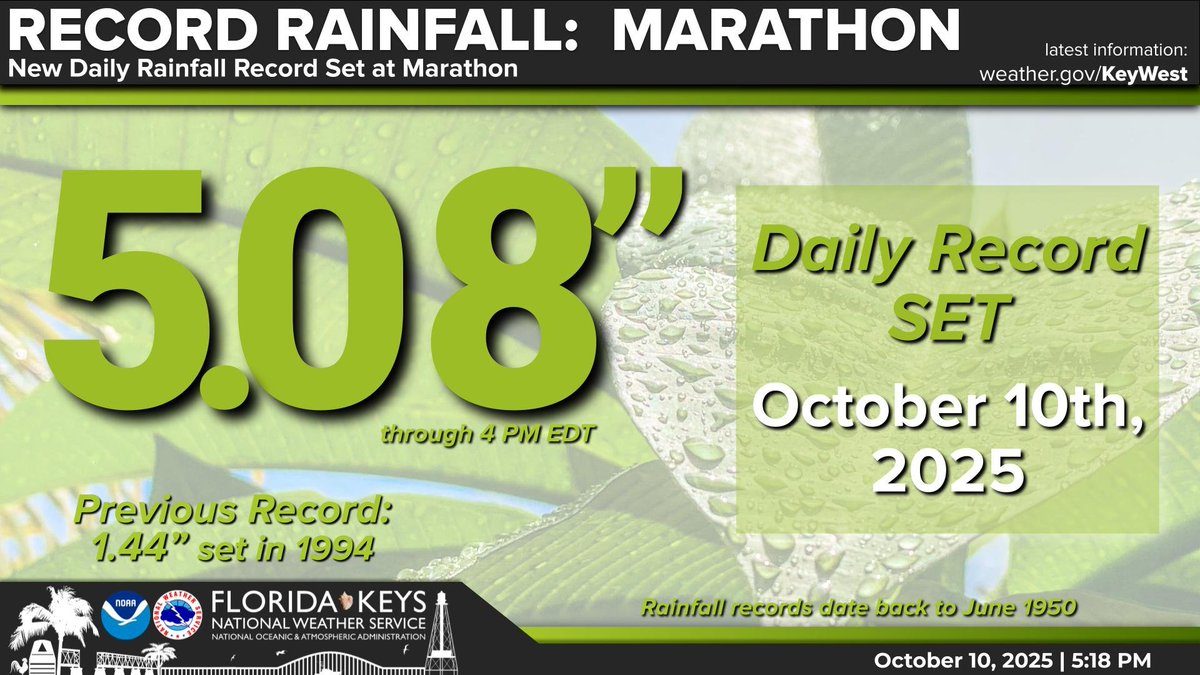
Not surprising for folks in the Middle Keys, Marathon set a new daily rainfall record of 5.08" (through 4 PM) today. The previous record was 1.44" from 1994.\n\nToday now ranks as the 4th wettest October day on record for the Marathon area.\n\n#flwx #FLKeys #MarathonFL
#FloridaKeys. A Marginal Risk for Excessive Rainfall or Level 1/4 has been issued for the #FLKeys. The Marginal Risk remains in effect until 8 AM EDT Sat morning. Shower chances decrease tomorrow morning. Please keep coastal flooding in mind and take caution near flooded roads.

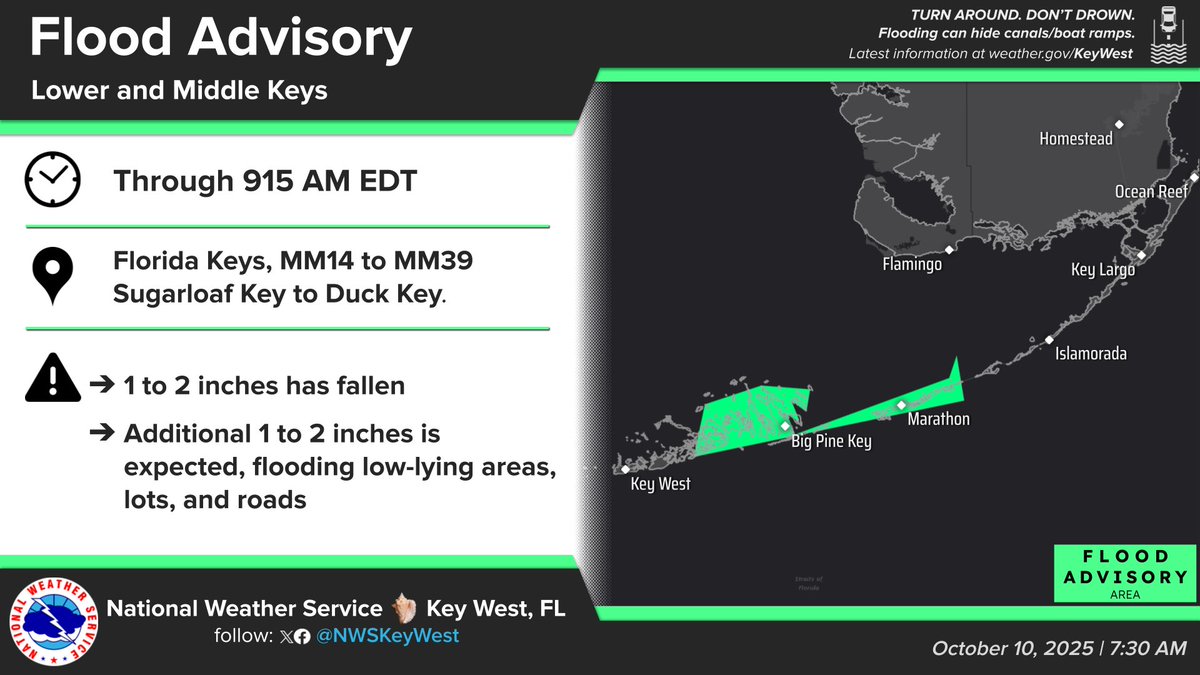
A Flood Advisory is in effect for a portion of the Lower & Middle Keys (MM14-MM39; Sugarloaf Key to Duck Key). The advisory is in effect until 915 AM EDT. 1 to 2" of rain has already fallen with an additional 1 to 2" expected. Flooding of low-lying areas, lots, & roads. #flwx
Happy Friday, #FloridaKeys! A Coastal Flood Advisory continues for all Florida Keys through early Sat. Rain chances peak near 90% today before falling through the weekend. Locally heavy rain is possible, potentially exacerbating the coastal flooding issues. #flwx #FLKeys


#FloridaKeys! A Coastal Flood Advisory remains in effect for ALL Florida Keys thru early Fri morning. In addition, elevated rain chances continue thru Fri night. A combination of King tides & rainfall can create brackish water (combination of salt & fresh water). #flwx


#FloridaKeys! A Coastal Flood Advisory remains in effect for ALL Florida Keys thru early Thu morning. In addition, elevated rain chances continue thru the end of the week. A combination of King tides & rainfall can create brackish water (combination of salt & fresh water). #flwx


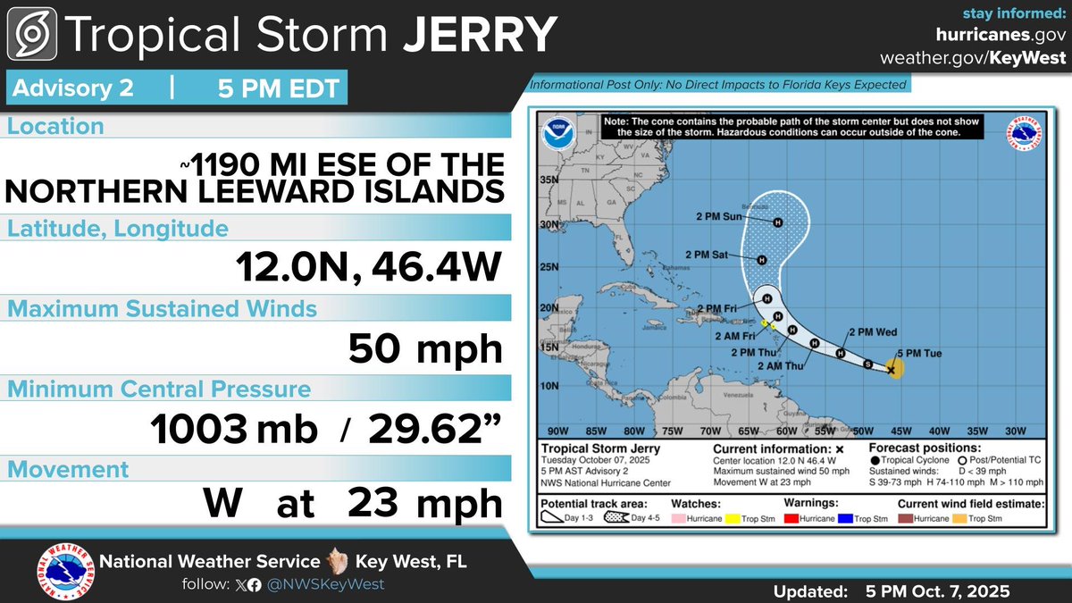
Oct 7 5 PM Update: The National Hurricane Center is issuing forecasts for Tropical Storm Jerry in the central Atlantic. Jerry is forecast to recurve into the northern Atlantic, and no threats to the Florida Keys are expected.
#FloridaKeys! A Coastal Flood Advisory remains in effect for ALL Florida Keys thru early Wed morning. In addition, elevated rain chances are anticipated thru end of the week. A combination of King tides & rainfall can create brackish water (combination of salt & fresh water).


A Coastal Flood Advisory remains in effect for all #FLKeys. Use caution when driving along flooded roads. Boaters will see less clearance under fixed bridges, especially during high tide. Please visit weather.gov/KeyWest for more info. #FloridaKeys #FLwx
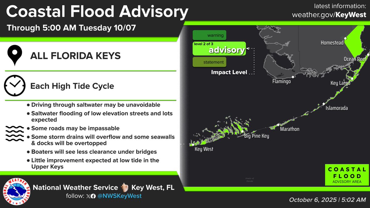
A COASTAL FLOOD ADVISORY is in effect for all Florida Keys. High tides approximately 1.5 ft above normal will lead to saltwater flooding. Driving thru saltwater may be unavoidable. Boaters will see less clearance under fixed bridges, especially at times of high tide.

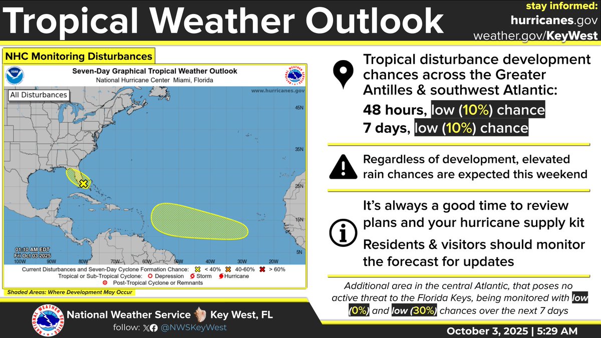
#FloridaKeys A Coastal Flood Advisory remains in effect for the Upper Keys; A Coastal Flood Statement remains Middle & Lower Keys. Meanwhile, a tropical disturbance ~the Bahamas has a 10% development chance over 7 days; C Atlantic medium 50% chance development in 7 days. #flwx
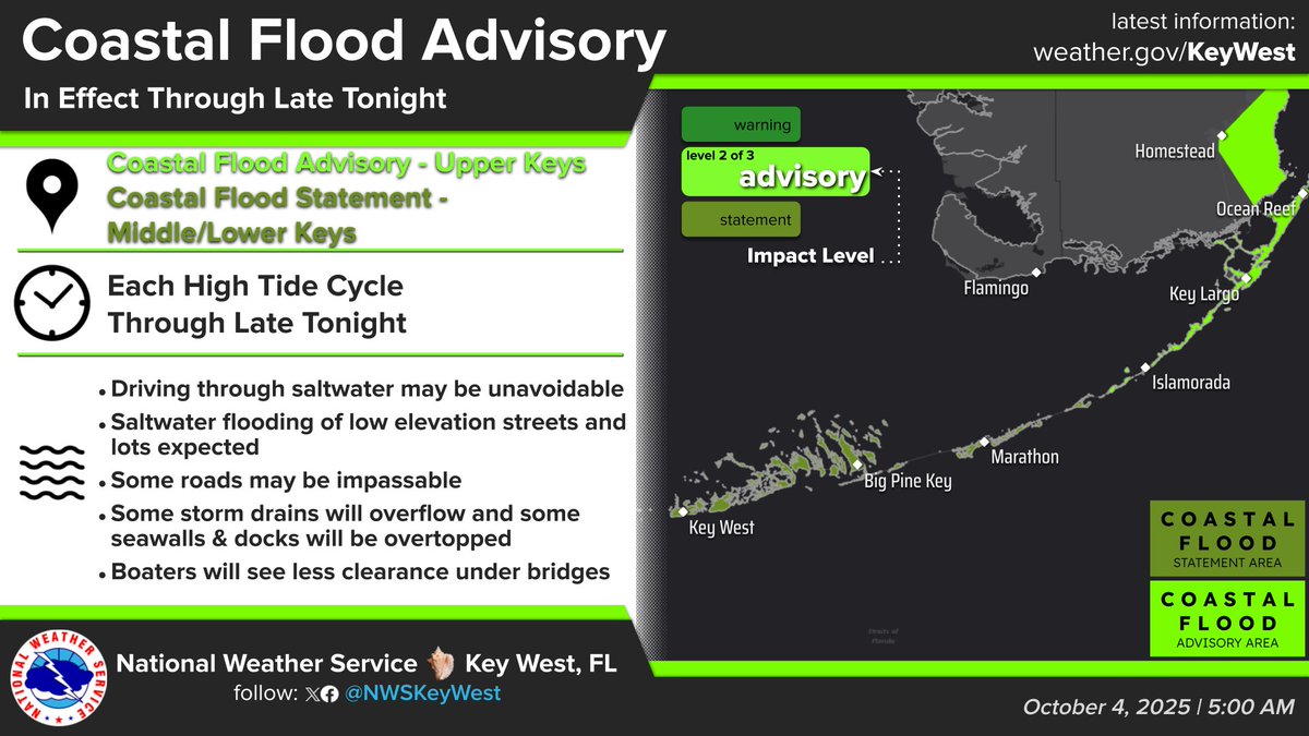

#FloridaKeys A Coastal Flood Advisory is now in effect for the Upper Keys; A Coastal Flood Statement remains Middle Keys. Meanwhile, a tropical disturbance near the Bahamas has a 10% development chance over the next week. As a result, elevated rain chances this weekend. #flwx

Aviso Especial Marítimo continúa Estrecho de Florida desde Ocean Reef a Craig Key hacia afuera 20 MN y Canal Hawk desde Ocean Reef hasta Craig Key hacia afuera del arrecife hasta la 1:45 AM EDT

Special Marine Warning continues for the Straits of Florida from Ocean Reef to Craig Key out 20 NM and Hawk Channel from Ocean Reef to Craig Key out to the reef until 1:45 AM EDT
Aviso Especial Marítimo incluye Estrecho de Florida desde Ocean Reef a Craig Key hacia afuera 20 MN y Canal Hawk desde Ocean Reef hasta Craig Key hacia afuera del arrecife hasta la 1:45 AM EDT


United States 趨勢
- 1. Discussing Web3 N/A
- 2. Good Sunday 41.5K posts
- 3. Auburn 46.5K posts
- 4. At GiveRep N/A
- 5. MACROHARD 6,812 posts
- 6. Brewers 66.2K posts
- 7. #SEVENTEEN_NEW_IN_TACOMA 36.7K posts
- 8. Gilligan's Island 5,019 posts
- 9. Wordle 1,576 X N/A
- 10. Georgia 67.8K posts
- 11. Utah 25.3K posts
- 12. #MakeOffer 19.4K posts
- 13. Cubs 56.9K posts
- 14. #SVT_TOUR_NEW_ 28.9K posts
- 15. Kirby 24.3K posts
- 16. #HawaiiFB N/A
- 17. QUICK TRADE 2,335 posts
- 18. #BYUFOOTBALL 1,027 posts
- 19. mingyu 103K posts
- 20. Holy War 2,083 posts
你可能會喜歡
-
 NOAA Aircraft Operations Center
@NOAA_HurrHunter -
 National Hurricane Center
@NHC_Atlantic -
 NWS Miami
@NWSMiami -
 City of Key West
@City_of_KeyWest -
 NWS LMRFC
@NWSLMRFC -
 NWS Climate Prediction Center
@NWSCPC -
 Key West Police Dept
@KWPOLICE -
 NWS Tampa Bay
@NWSTampaBay -
 NWS Southern Region
@NWSSouthern -
 Florida Keys Sheriff
@keyssheriff -
 NWS Lubbock
@NWSLubbock -
 NOAA Communications
@NOAAComms -
 Key West Seaport
@HistoricSeaport -
 Key West - Party in Key West
@PartyInKeyWest -
 National Hurricane Center
@NWSNHC
Something went wrong.
Something went wrong.