
NWS Corpus Christi
@NWSCorpus
Official X account for the National Weather Service Forecast Office Corpus Christi, TX. Details: http://weather.gov/nws_x
You might like


With summer heat now now in place across South Texas. Make sure to know the signs of heat-related illness. Take steps to reduce the threat and keep an eye out on the most vulnerable (children, elderly, pets, etc).

A Coastal Flood Advisory including the Middle Texas Coast and barrier islands remains in effect through Sunday morning. Conditions will be hazardous, especially during times of high tide. A MODERATE risk of rip currents will also be present. Please use caution at the beach!

There is a MODERATE risk of rip currents along Gulf-facing beaches today. In addition, coastal flooding poses a risk early this morning then again heading into the evening when high tide occurs. Please use caution if you plan to go to the beach. Beach roads may be impassable.

Dry, calm, and mostly clear tonight with lows dropping into the low to mid 60s inland! There is also a very low chance of patchy fog over the inland Coastal Plains and Brush Country.

A Coastal Flood Advisory including the bays and Gulf-facing beaches along the Middle Texas Coast remains in effect through this morning. Additional advisories may be needed. Beach roads will be inundated at times. There is also a MODERATE risk of rip currents.

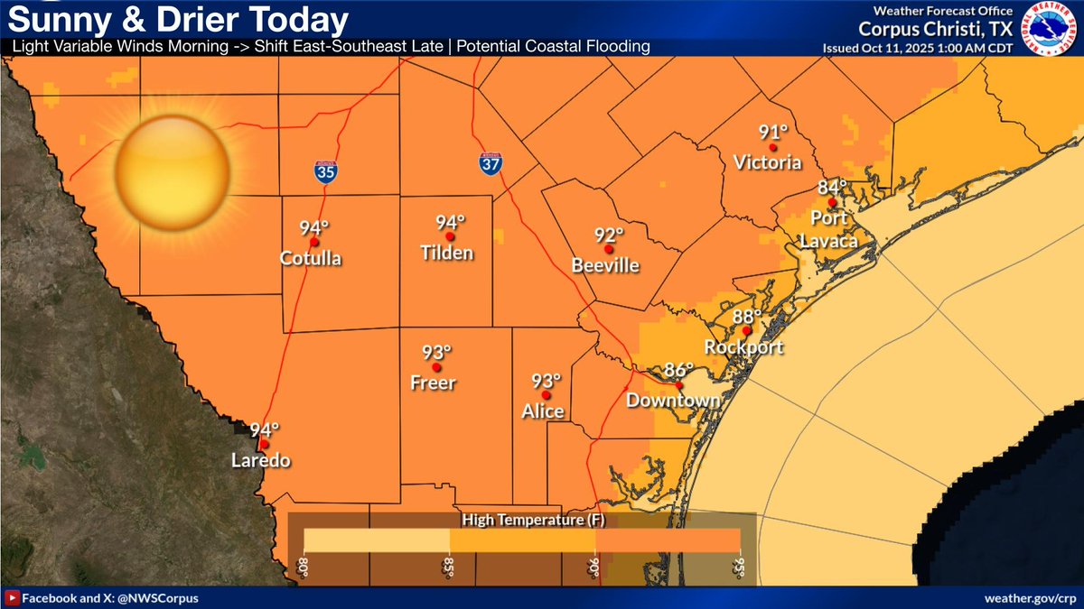
Sunny and dry today with light variable winds shifting southeasterly late. Highs will generally range from the mid 80s along the coast to the mid 90s over the Brush Country. Relative humidity can drop as low as 25-40% inland.
Dry and steady temperature conditions continue through the middle of next week, little to no rain chances. High temperatures will continue to range from the mid 80s to the mid 90s inland. Lows drop into the low-mid 60s inland but remain in the low-mid 70s near the coast.

Drier and persistent conditions take over this weekend with little to no rain chances going into the middle of next week. High temperatures will continue to range from the mid 80s along the coast to the mid 90s inland. Lows will range from the low-mid 60s inland to mid 70s coast.

A Coastal Flood Advisory now includes the bays in addition to Gulf-facing beaches along the Middle Texas Coast. Conditions will be hazardous, especially during times of high tide. Beach roads will be inundated at times. There is also a MODERATE risk of rip currents.

A Coastal Flood Advisory remains in effect through 7 AM this morning for barrier islands along the Middle Texas Coast. Additional advisories will likely be needed later this afternoon/evening and through the weekend during high tide. There is also a MODERATE risk of rip currents.

There is a MODERATE risk of rip currents along Gulf-facing beaches today. In addition, coastal flooding will likely occur during high tide late this afternoon/evening. Please use caution! Beach roads may be impassable, especially around high tide.

Drier, calm, and mostly clear tonight with lows dropping into the low to mid 60s inland! Not as much of a drop in temperatures along the coast but there will be some sort of relief from the typical lows in the upper 70s.

A Small Craft Advisory remains in effect for the open waters through 10 AM this morning. Northeasterly winds around 20 knots with gusts up to 25 knots and seas 5-7 ft are expected. Mariners, please use caution!

Drier and persistent conditions take over this weekend with little to no rain chances going into the middle of next week. High temperatures will continue to range from the mid 80s along the coast to the mid 90s inland. Lows will range from the low-mid 60s inland to mid 70s coast.

Drier conditions and mostly sunny today with east-northeasterly winds 10-15 mph. Heat indices will likely stay below 100°F as dewpoints fall into the 50s-60s. Highs will stay generally range from the mid 80s along the coast to the mid 90s over the Brush Country.

Drier conditions take over this weekend with little to no rain chances going into early next week. High temperatures will range from the mid 80s along the coast to the mid 90s inland. Lows will be able to drop down into the mid 60s inland but stay in the mid 70s along the coast.

Temperatures across area beaches today will be in the mid 80s with mostly sunny conditions. The rip current risk is low, but this does not mean no risk. Please use caution in the water!

Northeast winds will strengthen today over the open waters, with sustained around 20 knots and gusts around 25 knots, resulting in 5-7 ft seas. Therefore a Small Craft Advisory has been issued for the open waters through Friday morning.

Muggy and warm conditions tonight with lows ranging from the upper 60s to mid 70s under partly cloudy skies becoming mostly clear. A Small Craft Advisory remains in effect over the open waters through the night.

NE winds are forecast to increase on Thursday and persist thru Fri (near 20 kt sustained gusting as high as 25 kt), resulting in 5-7 ft seas. A Small Craft Advisory has been issued for the open waters (out to 60 nm) from Baffin Bay to Matagorda Bay from Thu AM to Fri AM.

Another warm day with low rain chances and muggy conditions. Starting tomorrow drier conditions take hold with not much change to daytime highs into next week. Cooler lows this weekend.


United States Trends
- 1. Auburn 45.2K posts
- 2. Brewers 64K posts
- 3. Georgia 67.9K posts
- 4. Cubs 55.7K posts
- 5. Kirby 24K posts
- 6. Arizona 42.1K posts
- 7. Utah 24.7K posts
- 8. Gilligan 5,878 posts
- 9. #AcexRedbull 3,760 posts
- 10. Michigan 63K posts
- 11. Hugh Freeze 3,218 posts
- 12. #BYUFootball N/A
- 13. #Toonami 2,586 posts
- 14. Boots 50.8K posts
- 15. Amy Poehler 4,387 posts
- 16. #GoDawgs 5,566 posts
- 17. #byucpl N/A
- 18. Kyle Tucker 3,176 posts
- 19. Dissidia 5,642 posts
- 20. Tina Fey 3,370 posts
You might like
-
 NWS Lubbock
@NWSLubbock -
 NWS LMRFC
@NWSLMRFC -
 NWS Brownsville
@NWSBrownsville -
 NWS Lake Charles
@NWSLakeCharles -
 KIII 3 News
@kiii3news -
 Corpus Christi Office of Emergency Management
@ReadyCC -
 KRIS 6 News
@KRIS6News -
 City of Corpus Christi
@cityofcc -
 Corpus Christi PD
@CorpusChristiPD -
 NWS Southern Region
@NWSSouthern -
 Corpus Christi Caller-Times
@callerdotcom -
 NWSSanAngelo
@NWSSanAngelo -
 NWS Austin/San Antonio
@NWSSanAntonio -
 NWS Midland
@NWSMidland -
 Corpus Christi International Airport (CCIA)
@flyccia
Something went wrong.
Something went wrong.