


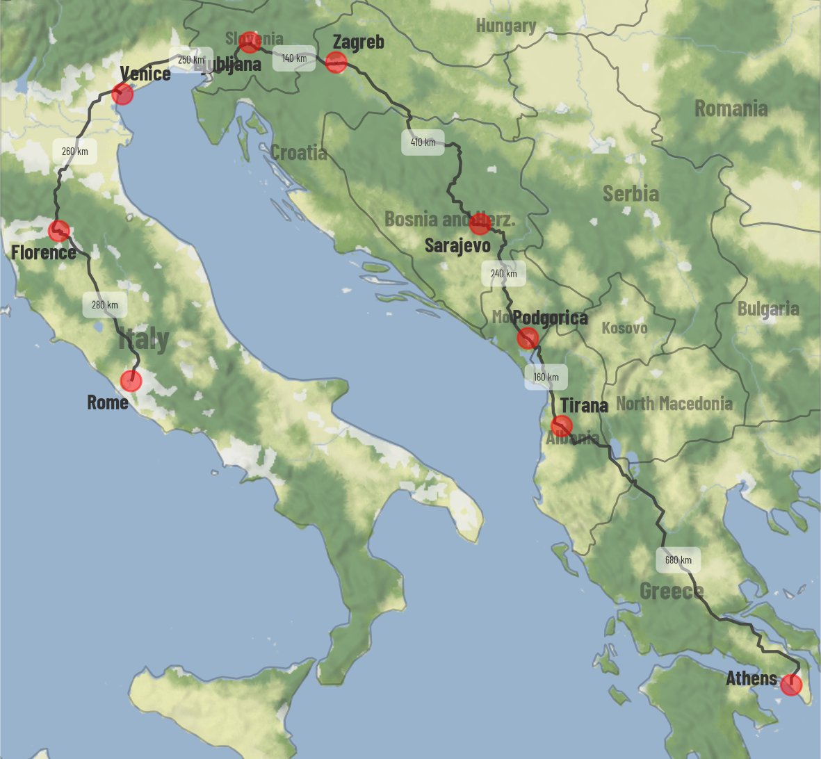
The largest road network TSP instance with 81,998 locations solved optimally was crafted using OSRM! A groundbreaking milestone in computational mathematics. Check out the details here: math.uwaterloo.ca/tsp/korea/inde… #TSP #Optimization #OSRM
🎉 Big news! OSRM v6.0.0 is live! 🚀 This release boasts 100+ changes, contributions from 170+ developers, and welcomes dozens of first-time contributors! 🌍 Huge thanks to our amazing community! 💪❤️ github.com/Project-OSRM/o… #OpenStreetMap #OSRM #RoutingEngine #OSM

OSRM v6.0.0-rc2 is here, packed with performance enhancements, improved algorithm efficiency, and a host of new features designed to take your navigation solutions to the next level. github.com/Project-OSRM/o…
github.com
Release v6.0.0-RC.2 · Project-OSRM/osrm-backend
What's Changed Fix Docker build by @DennisOSRM in #7134 Fix compiltion on arm64/Linux docker build by @DennisOSRM in #7136 Bring back to installing header files and lib by @jcoupey in #7140 os...
OSRM v6.0-rc1 is here, packed with performance enhancements, improved algorithm efficiency, and a host of new features designed to take your navigation solutions to the next level. github.com/Project-OSRM/o…


#dataviz How to plot Driving Directions using Open Street Maps Routing Service in R Data: @openstreetmap @ors_news Code 🔗 tinyurl.com/open-drive-maps Tools #rstats #ggplot2 #sf, {tidygeocoder} by @JesseCambon @dhernangomez, {osrm}, {ggmap} by @davidjkahle

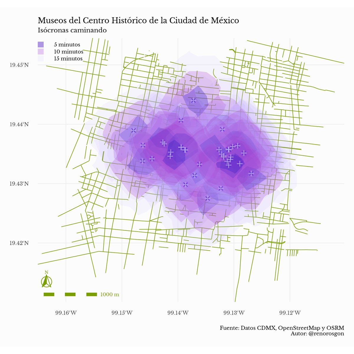
#30DayMapChallenge Día 12 - Tiempo y espacio Pasó de ser algo analítico a algo que evoca a las jacarandas de la CDMX. Aquí muestro la distancia que puedes recorrer a pie desde cada uno de los museos del Centro Histórico usando data de @openstreetmapmx y @ProjectOSRM #rstats
Multiplatform Maps Built As Layers on Rust (with Ian Wagner) youtu.be/WL0jY51PQR8?si… via @YouTube
youtube.com
YouTube
Multiplatform Maps Built As Layers on Rust (with Ian Wagner)
We are entertaining the idea of introducing Rust to our C++ code base. 🦀


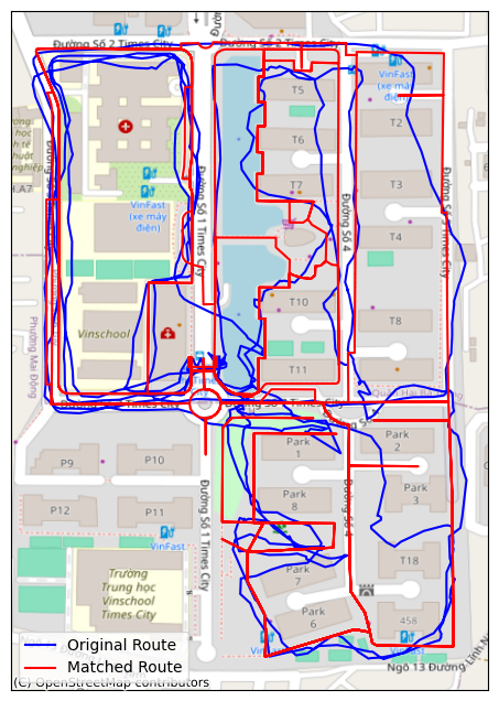
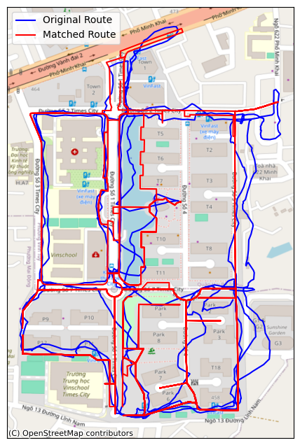
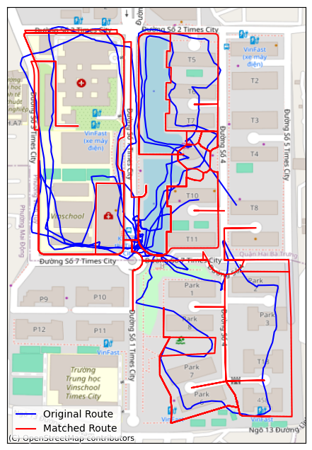
If I drop non pedestrian ways from OSM and use OSRM route service right after OSRM match service, I get precise fit to streets. This works really well
Navigating India with OSRM‘s leading technology and custom models. tech.olakrutrim.com/navigating-ind…
tech.olakrutrim.com
Navigating India - The Journey of Ola Maps
Mapping is a core pillar for mobility. They're not just about getting from point A to point B; they're about understanding the intricate web of streets, traffic patterns, and urban landscapes that...
The Socioeconomic Profile of Commuters Likely Affected by Bridge Collapse — an analysis by @uscensusbureau using OSRM. census.gov/library/storie…


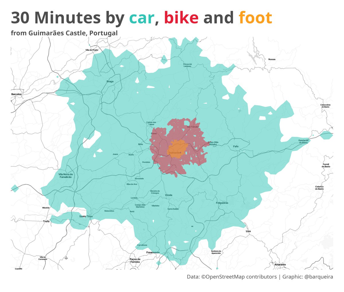
How far can one drive, cycle, and walk from the Castle of Guimarães ("Portugal Was Born Here") in 30 minutes? Credits to @VictimOfMaths Data: @ProjectOSRM via {osrm} #rstats #Portugal #dataviz #rspatial

Hey @ProjectOSRM I am working on a Cython wrapper for osrm-backend. Check it out github.com/enricodvn/pyos…

Hey @Mapbox, could you help us free OSRM‘s NodeJS package. You folks are listed as the only collaborators, and we‘d like to push new releases. Thanks! npmjs.com/package/osrm
OSRM is back with a new release! v5.27.0 contains a year's worth of bug fixes, routing improvements, and code modernization. github.com/Project-OSRM/o…


United States 趨勢
- 1. Ohtani 223K posts
- 2. Dodgers 267K posts
- 3. Emiru 8,502 posts
- 4. World Series 62.8K posts
- 5. Carson Beck 16.7K posts
- 6. Miami 101K posts
- 7. Louisville 28.6K posts
- 8. Brewers 57.1K posts
- 9. Babe Ruth 3,576 posts
- 10. Nebraska 17.8K posts
- 11. Massie 32K posts
- 12. NOCHE IS BACK 31.5K posts
- 13. #HeartofTaehyung 29.4K posts
- 14. NLCS 63.8K posts
- 15. TwitchCon 24.4K posts
- 16. #SEVENTEEN_NEW_IN_LA 64.9K posts
- 17. George Santos 87.1K posts
- 18. Sam Harris 1,109 posts
- 19. #OnTheRoadAgainLA 1,335 posts
- 20. 10 Ks 4,943 posts


Something went wrong.
Something went wrong.