#arcgissolutions search results

The list of #ArcGISSolutions compatible with #ArcGISEnterprise is getting longer! Explore the eight solutions newly ready to deploy on Enterprise 11.1 Check it out: esri.social/SUbe50NQZvL


The #ArcGISSolutions November 2023 release is here! Did you know that ArcGIS Solutions is included with your #ArcGISOnline subscription? Explore the seven newly released solutions and learn more here ➡️ esri.social/CTVh50Q5Xrr
The #ArcGISSolutions June 2023 release is here! Explore 12 new solutions included with your #ArcGISOnline subscription at no additional cost. Learn more -> esri.social/q3Bt50OTR50


Discover the latest in #ArcGISSolutions! The June 2024 release is packed with new tools for governments, utilities, and more. Dive into this blog for all the details on how these updates can enhance your operations. Learn more: esri.social/6vm850SuQA5

Did you know that #ArcGISSolutions are included with your #ArcGISOnline subscription? Learn about the Parks and Grounds Management solution ➡️ esri.social/oqu650PJmzT

#ArcGISSolutions has released an Election Results solution to help organizations share clear election result maps. Learn more about this solution, included with your #ArcGISOnline subscription. esri.social/3OLQ50QuE8k

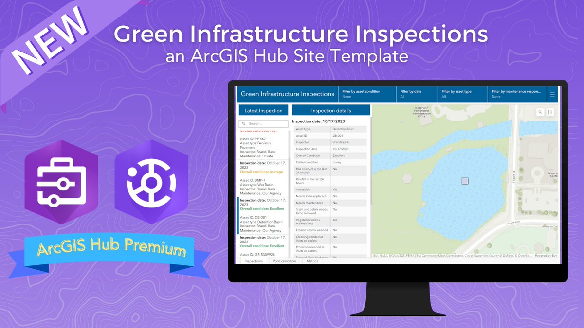
The #ArcGISSolutions November 2023 release includes a new #ArcGISHub -site template: Green Infrastructure Inspections. This solution is used to streamline inspections to ensure stormwater runoff is being managed effectively. Learn more ➡️ esri.social/Ueon50Q7CBk

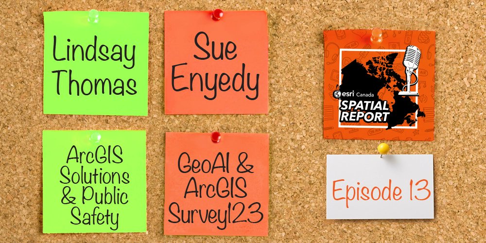
Tune in to the final episode of the #SpatialReport #podcast to hear from our guest, Janis Lapointe on how #ArcGISSolutions provides a collection of industry-specific configurations of ArcGIS that align with your organization's needs: ow.ly/2xAF50V5BkL

The #ArcGISSolutions June 2023 release includes four new #ArcGISHub Initiative Templates: Adopt-A-Hydrant, Adopt-A-Stop, Adopt-A-Tree, and Water Utility Service Interruptions. Explore the blog to learn more -> ow.ly/JBR350P3AAG

The #ArcGISSolutions June 2023 release includes four new #ArcGISHub Initiative Templates: Adopt-A-Hydrant, Adopt-A-Stop, Adopt-A-Tree, and Water Utility Service Interruptions. Explore the blog to learn more -> esri.social/QG1L50OTi6m

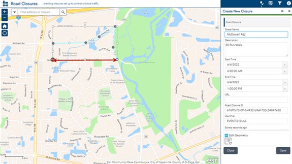
When you embed the Road Closures map in your public works website, community members have immediate access to current road-closure and detour information. ow.ly/vAFm104M7Jq #ArcGISSolutions
With the help of the #ArcGISSolutions Citizen Problem Reporter solution and #ArcGISHub site, the City of Haysville, Kansas, has transformed the way they address citizen nonemergency concerns. Read the story here ➡️ esri.social/An5Z50R7Tej

The #ArcGISSolutions November 2023 release includes an enhancement to the #ArcGISHub site template: Emergency Management Operations. This solution is used to share essential information during an emergency. Learn more ➡️ esri.social/agzA50Q7CEG

The #ArcGISHub team is excited to partner with #ArcGISSolutions to invite you to our webinar, coming February 21st, 2024: Improve Infrastructure Projects with Community Input Using ArcGIS. Registration is now live! Secure your spot here ➡️ esri.social/96aj50QrSMp

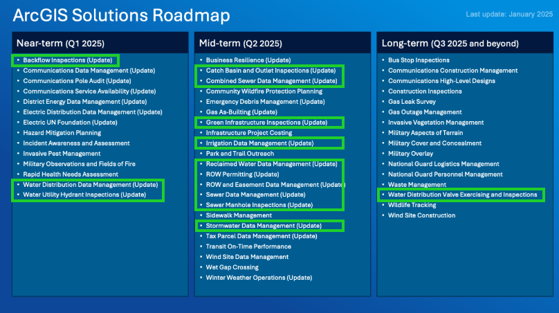
The ArcGIS Solutions 2024 Product Roadmap is here! It provides a sneak peek at the major capabilities planned for #ArcGISSolutions for the remainder of 2024 and beyond. ow.ly/uuym50SwBFj


The ArcGIS Solutions 2024 Product Roadmap is here! It provides a sneak peek at the major capabilities planned for #ArcGISSolutions for the remainder of 2024 and beyond. ow.ly/UayU50SvQ6Z
If you manage, inspect, or maintain stormwater assets, #ArcGISSolutions has been working hard to make your workflow easier! Learn about the four stormwater solutions, included with your #ArcGISOnline subscription: esri.social/PKwo50Qq1pE

Discover the latest in #ArcGISSolutions! The June 2024 release is packed with new tools for governments, utilities, and more. Dive into this blog for all the details on how these updates can enhance your operations. Learn more: ow.ly/qBeE50Tcq7o

The March 2024 ArcGIS Solutions release is here with new and enhanced solutions for state and local governments, utilities, defense, and public safety agencies. Visit the release blog to learn whats new in #ArcGISSolutions ➡️ esri.social/twhH50QQvj0

Tune in to the final episode of the #SpatialReport #podcast to hear from our guest, Janis Lapointe on how #ArcGISSolutions provides a collection of industry-specific configurations of ArcGIS that align with your organization's needs: ow.ly/2xAF50V5BkL

Have you seen the ArcGIS Solutions roadmap? There are a lot of solutions being updated! If you're not familiar with #ArcGISSolutions check them out. #EsriWater ow.ly/UK2250URe6y
Esri's #ArcGISSolutions has created a step-by-step data migration tutorial for the sewer industry (more industries to follow). Check out this #ArcGISBlog to learn more. #EsriWater #Wastewater esri.social/Scs150UsGIF
Discover the latest in #ArcGISSolutions! The June 2024 release is packed with new tools for governments, utilities, and more. Dive into this blog for all the details on how these updates can enhance your operations. Learn more: ow.ly/qBeE50Tcq7o
📢 Calling all GIS program managers! 🌍 Check out how ArcGIS Solutions' new GIS Request Management solution can help you streamline your program and promote the value of GIS to your stakeholders. ow.ly/5RIn30sFFNl #esri #ArcGISSolutions #GIS


📢 Calling all GIS program managers! 🌍 Check out how ArcGIS Solutions' new GIS Request Management solution can help you streamline your program and promote the value of GIS to your stakeholders. ow.ly/ap5N30sFwra #esri #ArcGISSolutions #GIS

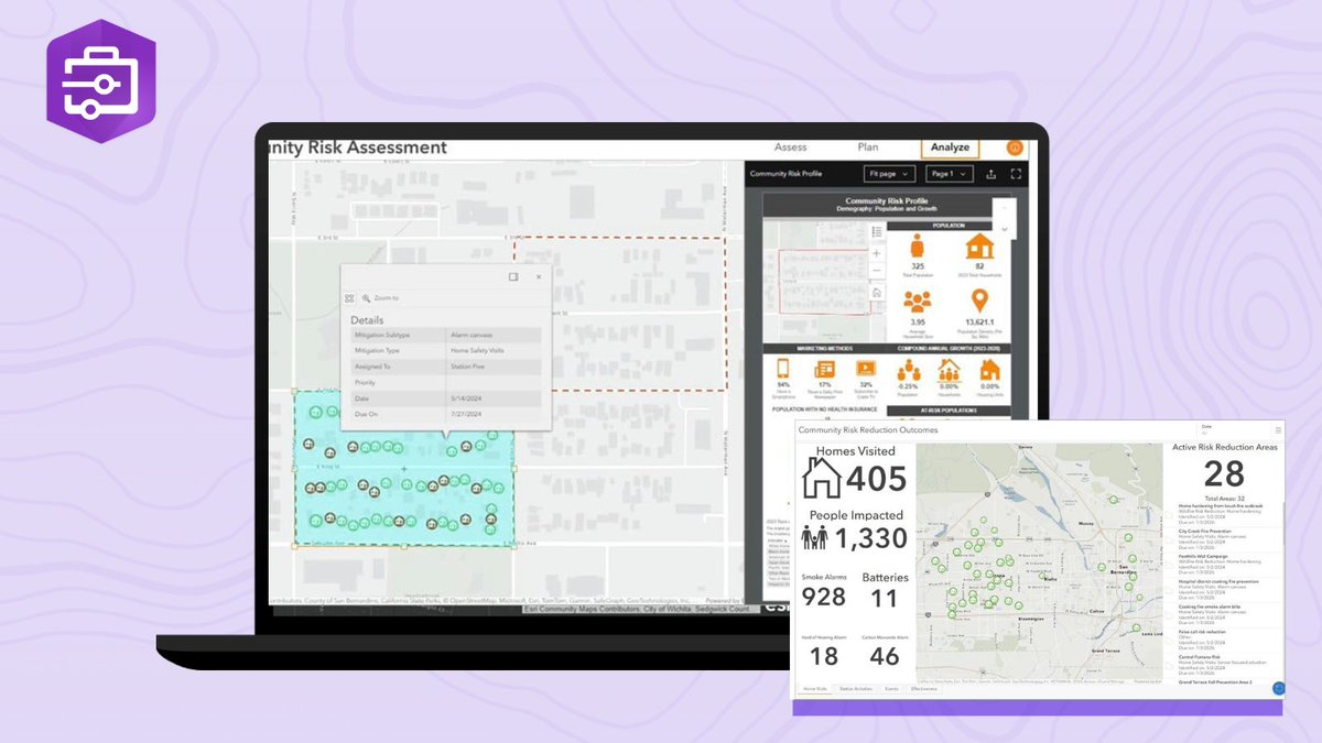
Empower your community with safety! The new #ArcGISSolutions Community Risk Reduction solution features a Hub site where you can access vital risk reduction education and submit non-emergency requests. Get involved and stay safe! Learn More ➡️ esri.social/Guil50SABtL
Discover the new #ArcGISSolutions Street Sweeping Operations solution. Monitor real-time activity, and access sweeping schedules and statuses publicly through our innovative Hub site. Stay updated effortlessly! Learn More ➡️ esri.social/JPfA50SABsU

The ArcGIS Solutions 2024 Product Roadmap is here! It provides a sneak peek at the major capabilities planned for #ArcGISSolutions for the remainder of 2024 and beyond. ow.ly/uuym50SwBFj
Discover the latest in #ArcGISSolutions! The June 2024 release is packed with new tools for governments, utilities, and more. Dive into this blog for all the details on how these updates can enhance your operations. Learn more: esri.social/6vm850SuQA5

The #ArcGIS Solutions 2024 Product Roadmap is here! It provides a sneak peek at the major capabilities planned for #ArcGISSolutions for the remainder of 2024 & beyond. ow.ly/u6G350SvUaL #GIS #Esri #URISA #NSGIC
esri.com
ArcGIS Solutions 2024 Product Roadmap
ArcGIS Solutions 2024 Product Roadmap
The ArcGIS Solutions 2024 Product Roadmap is here! It provides a sneak peek at the major capabilities planned for #ArcGISSolutions for the remainder of 2024 and beyond. ow.ly/UayU50SvQ6Z

FYI: @esricanada podcast - #Spatial Report: All Problems Have Solutions shorturl.at/n2pnI #ArcGISSolutions #PublicSafety #ArcGISSurvey123 #GeoAI #GIS #esriCanada #esri #mapping #TheScienceOfWhere @Esri @EsriFederalGovt @EsriSLGov @GISPublicSafety @ArcGISSurvey123
April 24th kicks off #WorldImmunizationWeek 💉 Discover how the #ArcGISSolutions Immunization Outreach solution, in collaboration with ArcGIS Hub, empowers communities with an interactive dashboard for enhanced involvement and education. #HubHints esri.social/ez4l50RntY3
With the help of the #ArcGISSolutions Citizen Problem Reporter solution and #ArcGISHub site, the City of Haysville, Kansas, has transformed the way they address citizen nonemergency concerns. Read the story here ➡️ esri.social/An5Z50R7Tej
Did you know that #ArcGISSolutions is included in your #ArcGISOnline subscription? Explore the new and enhanced solutions included in the March 2024 #ArcGISSolutions release ➡️ esri.social/g9j850QSe3G
esri.com
What’s new in ArcGIS Solutions March 2024 Release
New and updated ArcGIS Solutions released in March 2024
The March 2024 ArcGIS Solutions release is here with new and enhanced solutions for state and local governments, utilities, defense, and public safety agencies. Visit the release blog to learn whats new in #ArcGISSolutions ➡️ esri.social/twhH50QQvj0
#ArcGISSolutions has released an Election Results solution to help organizations share clear election result maps. Learn more about this solution, included with your #ArcGISOnline subscription. esri.social/3OLQ50QuE8k
Hey @EsriSLGov followers, join us for a webinar to see how #ArcGISSolutions and #ArcGISHub can be used together to make infrastructure improvements in your community. Use focused maps & apps to inform the public, enlist their feedback & engage volunteers in maintenance activities
The #ArcGISHub team is excited to partner with #ArcGISSolutions to invite you to our webinar, coming February 21st, 2024: Improve Infrastructure Projects with Community Input Using ArcGIS. Registration is now live! Secure your spot here ➡️ esri.social/96aj50QrSMp
If you manage, inspect, or maintain stormwater assets, #ArcGISSolutions has been working hard to make your workflow easier! Learn about the four stormwater solutions, included with your #ArcGISOnline subscription: esri.social/PKwo50Qq1pE


How Madison County, Kentucky solved their issue of locating snowplow trucks using #SnowCOP . p.ctx.ly/r/4zcc #ArcGISSolutions


The #ArcGISsolutions site has a new product experience! Come check out the site and see the new format. esri.com/arcgis-blog/pr… #esripublicsafety Solutions include: 🔹 Police transparency 🔹 Emergency management 🔹 Fusion center 🔹 Community health assessment
The #ArcGISSolutions June 2023 release is here! Explore 12 new solutions included with your #ArcGISOnline subscription at no additional cost. Learn more -> esri.social/q3Bt50OTR50
The #ArcGISSolutions November 2023 release is here! Did you know that ArcGIS Solutions is included with your #ArcGISOnline subscription? Explore the seven newly released solutions and learn more here ➡️ esri.social/CTVh50Q5Xrr

The list of #ArcGISSolutions compatible with #ArcGISEnterprise is getting longer! Explore the eight solutions newly ready to deploy on Enterprise 11.1 Check it out: esri.social/SUbe50NQZvL
New #Coronavirus recovery solutions are available, from testing sites locater maps to recovery dashboards ow.ly/mL4050zEE7V #ArcGISSolutions


Leverage #ArcGIS Solutions to jumpstart and streamline your #GIS workflows. Read the latest blog for more on installing and implementing #ArcGISSolutions - bit.ly/35a2cdV @ArcGISLocalGov @ArcGISStateGov @ArcGISforEM @ArcGISOnline @ArcGISPro @esriSurvey123 #OpsDashboard

Need an out-of-the-box solution to save time and effort? 😅⏱️ These focused maps and apps directly address challenges in a myriad of industries - and are now available in #ArcGISEnterprise. Check out #ArcGISSolutions today: ow.ly/WyjP50EXfVw

Did you know that #ArcGISSolutions are included with your #ArcGISOnline subscription? Learn about the Parks and Grounds Management solution ➡️ esri.social/oqu650PJmzT
ArcGIS Solutions has a whole new experience! Head on over to the new #ArcGISSolutions homepage to learn how the solutions align with your business needs and transform your use of ArcGIS. esri.com/en-us/arcgis/p… #arcgis #ArcgisOnline

The #ArcGISSolutions March 2023 release includes three new #ArcGISHub Initiative Templates: Adopt-A-Road, Immunization Outreach, and Roadway Management. Explore the templates: esri.social/zexO50Nxztu

Discover the latest in #ArcGISSolutions! The June 2024 release is packed with new tools for governments, utilities, and more. Dive into this blog for all the details on how these updates can enhance your operations. Learn more: esri.social/6vm850SuQA5
#ArcGISSolutions has released an Election Results solution to help organizations share clear election result maps. Learn more about this solution, included with your #ArcGISOnline subscription. esri.social/3OLQ50QuE8k
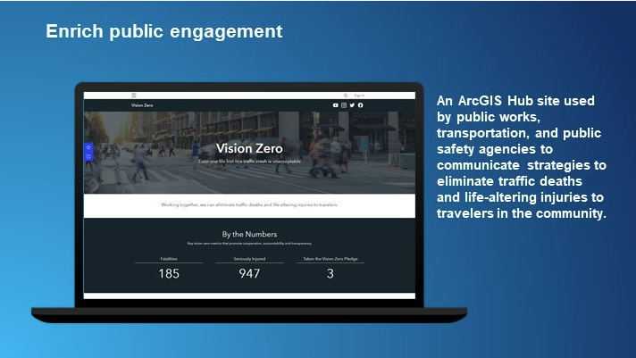
The #ArcGISSolutions Vision Zero solution includes a website template to build your #ArcGISHub site and other information products, survey forms, and dashboard apps that can enrich public engagement & enhance transportation planning processes See it here esri.social/Ju1550MVXKZ
Several new #ArcGISSolutions are now available that can help state and local governments, utilities, and public safety agencies accomplish their workflows. Some of the solutions have #ArcGISHub sites included. Check it out in this 2 minute article ow.ly/ZtKa50Fsol1
New and enhanced ArcGIS Solutions - There are three brand new #ArcGISSolutions, now available in the #ArcGISHub Template Gallery: 👍Broadband Outreach 👍Election Management 👍My Trash Services Learn more esri.social/j6eo50IZMVw


Learn about the new Community Health Outreach solution from Esri, and how you can quickly deploy it to serve your community. ow.ly/HKfq50DL7c2 #ArcGISSolutions

Something went wrong.
Something went wrong.
United States Trends
- 1. Sonny Gray 5,205 posts
- 2. Dick Fitts N/A
- 3. #yummymeets N/A
- 4. Red Sox 5,753 posts
- 5. #GMMTV2026 4.11M posts
- 6. Clarke 5,723 posts
- 7. Giolito N/A
- 8. National Treasure 4,298 posts
- 9. Thankful 50.5K posts
- 10. Gone in 60 1,442 posts
- 11. Happy Thanksgiving 19.7K posts
- 12. Breslow N/A
- 13. Joe Ryan N/A
- 14. #csm221 4,321 posts
- 15. Chaim 1,034 posts
- 16. Mark Kelly 249K posts
- 17. #OurCosmicClue_Wooyoung 27.3K posts
- 18. Academic All-District N/A
- 19. Raising Arizona N/A
- 20. Ghost Rider 1,755 posts