#arcgis search results

With the ReportAll Feature Service, GIS teams can access nationwide parcel data directly inside ArcGIS® products. As an Esri Gold Partner, ReportAll is built to support enterprise GIS teams at scale. Try it free for 30 days: reportallusa.com/products/featu… #GIS #ArcGIS #ParcelData


売上データを月別にピボットしたい 2つのフィーチャクラスをキーで突合して差分を出したい note.com/irr_gis/n/nc4c… #GIS #ArcGIS


How do diseases spread? 📍🦠 This #ArcGIS StoryMap uses spatial data to track outbreaks—from AC airflow in restaurants to city-wide density. Fascinating look at how geography shapes public health. 🗺️🚑 Explore here: ow.ly/Ap5o50YA05r

Ready to make an impact with geo apps? Join Esri's upcoming MOOC and learn to create powerful web, mobile, and desktop apps with #ArcGIS—no coding skills needed! The course starts April 8. Register now: ow.ly/Vbuo30sUprj

Add getting Esri-certified to your 2026 goals🌏! Whether you are a young professional or seasoned #ArcGIS user, there is a certification for everyone. Explore exams: ow.ly/pOGu30sSHoi


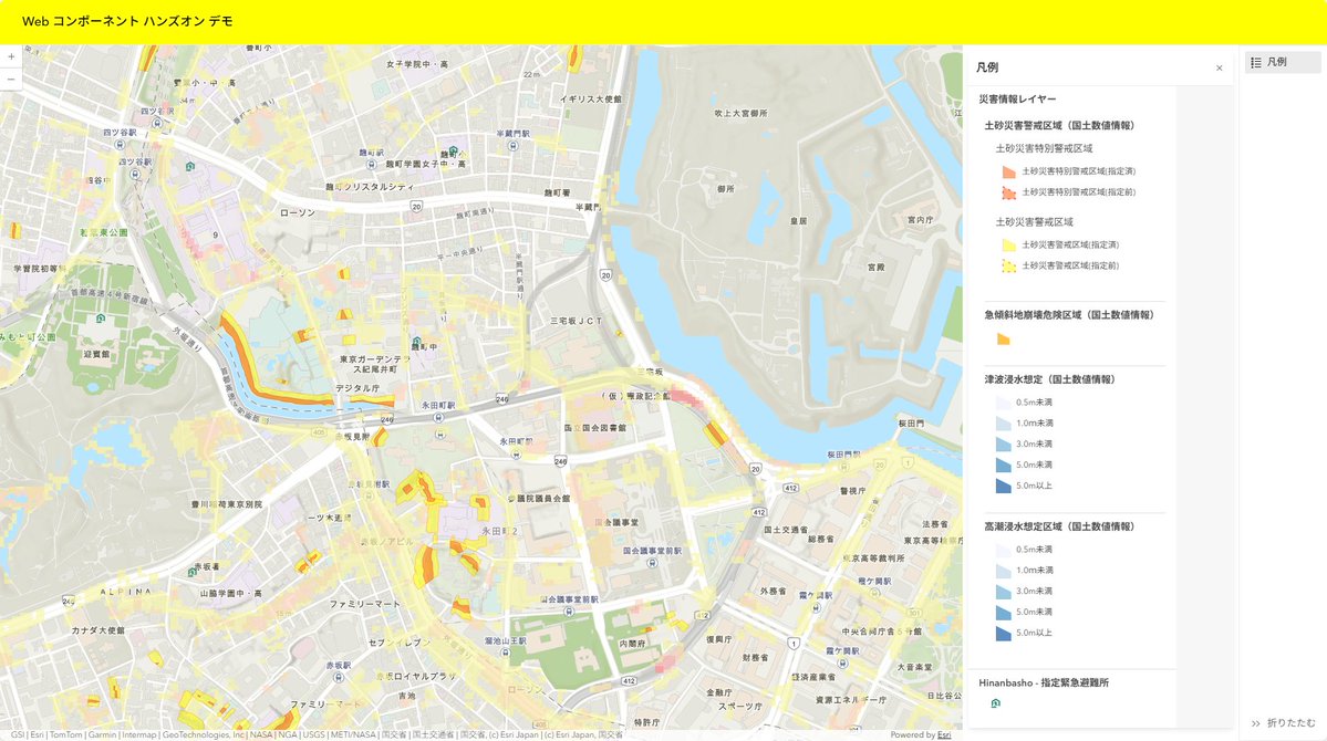
4/24 に Web コンポーネントでモダンな地図 Web アプリを作る入門ハンズオンを開催します! ArcGIS で Web コンポーネントを使用した開発の基礎について紹介します! #arcgis #javascript #Webアプリ
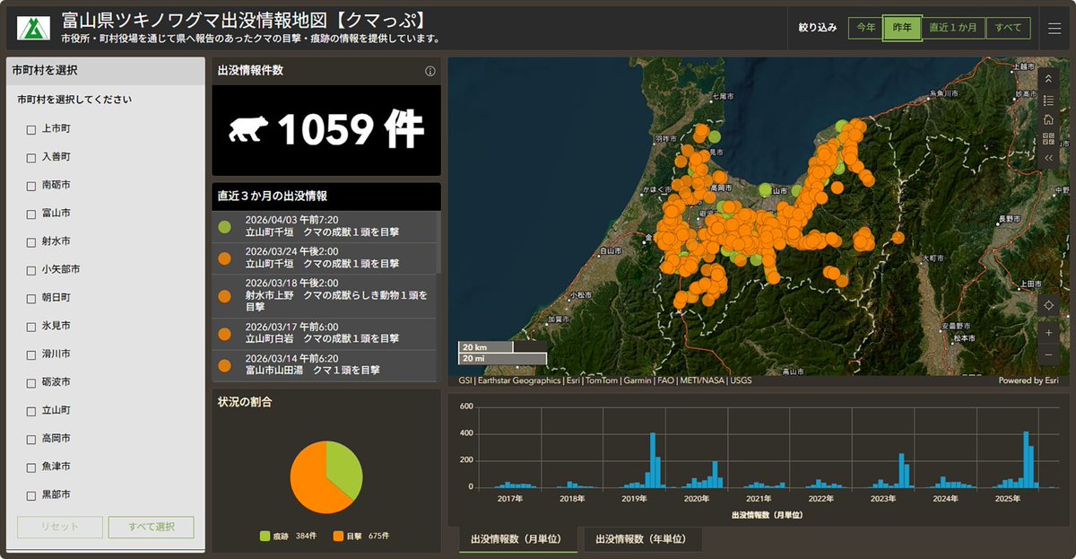
🐻🌸 先日、Esriジャパンのクマ出没情報ページに富山県の【クマっぷ】 が追加されました。 春になって暖かくなってきたから、冬眠していたクマが動き始めた…のかも?🤔 地図で最新の出没状況をチェックできます。 buff.ly/p7xHgXn #クマ出没情報 #GIS #ArcGIS #防災

Want to improve your #GIS data quality and reduce data management cost? #ArcGIS Data Reviewer is an extension for #ArcGISPro that automates, simplifies, and improves data quality management workflows. Try 21-day free trial: ow.ly/BQAP50YxPpa

Tutorial about How to generate NDVI Map of Sentinel satellite imagery with Python ? Tutorial Link: youtu.be/05rh4O4UGcQ?si… For more information about registration, visit our website: studyhacksgeospatial.com/google-earth-e… #googleearthengine #QGIS #ArcGIS #remotesensing #GIS #Training #GeoAI

世界で進むモバイル GIS 最新事例をご紹介します!~事例紹介:「フィールドで使える GIS」を実現する ArcGIS Maps SDK for Flutter~ |Esri Community Blog|[ community.esri.com/t5/a/a/ta-p/16… ] #ArcGIS #地図 #開発 #GIS #Flutter
![ESRIJapan's tweet image. 世界で進むモバイル GIS 最新事例をご紹介します!~事例紹介:「フィールドで使える GIS」を実現する ArcGIS Maps SDK for Flutter~
|Esri Community Blog|[ community.esri.com/t5/a/a/ta-p/16… ]
#ArcGIS #地図 #開発 #GIS #Flutter](https://pbs.twimg.com/media/HE3RhDQagAAm-z1.jpg)
ArcGIS Enterprise のコンポーネントの 1 つである ArcGIS Data Store について、各データ ストア タイプを分かりやすく解説しています。 ArcGIS Enterprise の利活用に、ぜひお役立てください。 |Esri Community Blog|[ community.esri.com/t5/a/a/ta-p/16… ] #ArcGIS #地図 #GIS #サーバー
![ESRIJapan's tweet image. ArcGIS Enterprise のコンポーネントの 1 つである ArcGIS Data Store について、各データ ストア タイプを分かりやすく解説しています。
ArcGIS Enterprise の利活用に、ぜひお役立てください。
|Esri Community Blog|[ community.esri.com/t5/a/a/ta-p/16… ]
#ArcGIS #地図 #GIS #サーバー](https://pbs.twimg.com/media/HDG4YEkaMAE4Frn.jpg)


📰 #ArcGIS Blog: Create a flow with ArcGIS Connectors for Microsoft Power Automate esri.com/arcgis-blog/pr… _ #Esri #GIS #Geospatial #MetaMapping
esri.com
Create a flow with ArcGIS Connectors for Microsoft Power Automate
Learn how to create your first flow with ArcGIS Connectors for Microsoft Power Automate, the tool for automating your spatial workflows.


How can cities use #AI to fight urban heat? 🌳🏠 See how Chattanooga mapped 5.3 million trees with @USDA data and created a heat index to plant 5000 trees where they matter the most. ow.ly/I0EW50YOMWC #ArborDay #StoryMaps #Forests250

Python is for EVERYONE—especially when you take this web course 🐍: ow.ly/SEj850YhpaO Save time by learning how to automate ArcGIS workflows 🌎. #GIS #ArcGIS #Python

Cómo conectar ArcMap y #ArcGIS Pro con #PostGIS rviv.ly/rA9h4T #ArcGISPro

Using charts in #ArcGIS Pro can give you a better understanding of your data. 📊🌎 This ✨new web course✨ will help get you started with various chart types in Pro! Get started: ow.ly/AwCV50YCAnW


Google Earth ya trae una capa de curvas de nivel y mucho más arcgeek.com #googleearth #sig #arcgis #qgis
Get product updates, expert tips, and curated resources delivered to your inbox. Sign Up for the #ArcGIS Pro Newsletter: ow.ly/ZGaG50YHi6A

With the ReportAll Feature Service, GIS teams can access nationwide parcel data directly inside ArcGIS® products. As an Esri Gold Partner, ReportAll is built to support enterprise GIS teams at scale. Try it free for 30 days: reportallusa.com/products/featu… #GIS #ArcGIS #ParcelData
売上データを月別にピボットしたい 2つのフィーチャクラスをキーで突合して差分を出したい note.com/irr_gis/n/nc4c… #GIS #ArcGIS

Going to #EGU26? If yes, stop by Esri booth 68/69 to see how #ArcGIS brings open science workflows, multidimensional analytics, and location intelligence together in one enterprise-ready geospatial platform. 🔬 Learn more: ow.ly/AgfP50YNcli

避難計画って地図化するとどこに穴があるかすぐ見える。逆に表だけ見てるとどんなに精緻に作っても抜けに気づきにくい。 note.com/irr_gis/n/n4ac… #arcpy #ArcGIS


NDVIや傾斜みたいなDEM・衛星派生のデータって、計算自体は数行で書けるけど閾値の落とし所で結局ノウハウが要る。ここは地域や対象によってかなり感覚的になる。 note.com/irr_gis/n/nc4d… #ArcGIS


Bring your CRM data to life with ESRI ArcGIS 🌍 See how advanced mapping elevates Dynamics 365 🚀 🔗 maplytics.com/blog/esri-arcg… #Dynamics365 #ArcGIS #LocationIntelligence #CRM #DataVisualization #FieldOps

📰 #ArcGIS Blog: Primary Design Principles for Cartography esri.com/arcgis-blog/pr… _ #Esri #GIS #Geospatial #MetaMapping
esri.com
Primary Design Principles for Cartography
Primary Design Principles for Cartography
How can cities use #AI to fight urban heat? 🌳🏠 See how Chattanooga mapped 5.3 million trees with @USDA data and created a heat index to plant 5000 trees where they matter the most. ow.ly/I0EW50YOMWC #ArborDay #StoryMaps #Forests250
📰 #ArcGIS Blog: Create a flow with ArcGIS Connectors for Microsoft Power Automate esri.com/arcgis-blog/pr… _ #Esri #GIS #Geospatial #MetaMapping
esri.com
Create a flow with ArcGIS Connectors for Microsoft Power Automate
Learn how to create your first flow with ArcGIS Connectors for Microsoft Power Automate, the tool for automating your spatial workflows.

⚠️No deje que las lluvias detengan su operación ⛈️ Con inteligencia geoespacial, puede predecir zonas vulnerables y optimizar rutas logísticas antes de que el clima se vuelva un problema. Conozca más ⬇️ geosis.com.sv #ArcGIS #GIS #Geosis


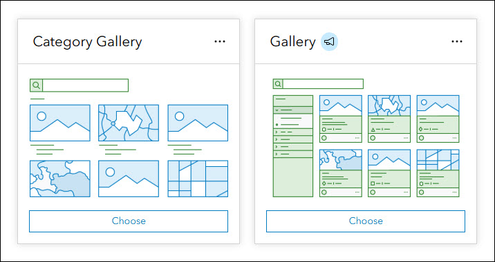
#ArcGIS Instant #Apps: Introducing Gallery tinyurl.com/49c9ueju #sharing #GIS #esri #maps #GISchat #geospatial @Esri @EsriFederalGovt @EsriSLGov @ArcGISOnline @URISA
📰 #ArcGIS Blog: Making Sense of Workload Separation in ArcGIS esri.com/arcgis-blog/pr… _ #Esri #GIS #Geospatial #MetaMapping
esri.com
Making Sense of Workload Separation in ArcGIS
Making Sense of Workload Separation in ArcGIS
NDVIや傾斜みたいなDEM・衛星派生のデータって、計算自体は数行で書けるけど閾値の落とし所で結局ノウハウが要る。ここは地域や対象によってかなり感覚的になる。 note.com/irr_gis/n/n377… #GIS #ArcGIS

このデータ、またダウンロードページからポチポチ落とすの? これ、自動化できるはずだ note.com/irr_gis/n/n5b5… #arcpy #ArcGIS

📰 #ArcGIS Blog: Prepare your data for the National Spatial Reference System modernization of 2022 in the U.S. esri.com/arcgis-blog/pr… _ #Esri #GIS #Geospatial #MetaMapping

UniqueValueRendererをarcpyで動的に設定する note.com/irr_gis/n/n0af… #ArcGIS

📰 #ArcGIS Blog: Modernizing ArcGIS Pro with VDI: Why Hyper-V Is Back in the Conversation esri.com/arcgis-blog/pr… _ #Esri #GIS #Geospatial #MetaMapping
esri.com
Modernizing ArcGIS Pro with VDI: Why Hyper-V Is Back in the Conversation
Modernize ArcGIS Pro with VDI using Hyper-V. Learn why it’s gaining momentum, how it fits hybrid strategies, and where it delivers real performance benefits.
📰 #ArcGIS Blog: Miniature Mapping esri.com/arcgis-blog/pr… _ #Esri #GIS #Geospatial #MetaMapping
esri.com
Miniature Mapping
Have you ever considered adding miniatures to a map?

In #ArcGIS #Survey123 you can share surveys publicly, with your org, or specific groups. Control who can add, edit and delete records. Use links, QR codes or embed in websites, perfect for field teams and stakeholders. 🔗📲 ow.ly/1mJJ50YNaAo


Something went wrong.
Something went wrong.
United States Trends
- 1. Klay N/A
- 2. #WeWantKairi N/A
- 3. UDFA N/A
- 4. #UFCVegas116 N/A
- 5. Ottawa N/A
- 6. Lu Dort N/A
- 7. Corey Day N/A
- 8. Uar Bernard N/A
- 9. Garrett Nussmeier N/A
- 10. Devin Booker N/A
- 11. Sens N/A
- 12. Jordan Leasure N/A
- 13. Brady Tkachuk N/A
- 14. Eli Heidenreich N/A
- 15. Durden N/A
- 16. #OlandriaCoachellaVlog N/A
- 17. Tory N/A
- 18. Trey Smack N/A
- 19. Deion Burks N/A
- 20. Harold Perkins N/A