#arcgisvelocity نتائج البحث

ArcGIS Velocity から Microsoft Teams への通知方法をご紹介! #ArcGIS #ArcgisVelocity #MicrosoftTeams #AdaptiveCard blog.esrij.com/?p=68000

Tracking firefighters in rugged, disconnected areas is challenging. See how GPS and #ArcGISVelocity—a SaaS IoT app for #ArcGISOnline—enable real-time location tracking, enhancing safety in wildland firefighting. Read more: esri.social/gvo350TVXbY

From public disorder to weather threats, real-time risk detection is critical. #ArcGISVelocity integrates #EsriPartner Dataminr alerts into live dashboards—giving teams the insight they need to act fast and stay ahead. Read the article 👇 ow.ly/JyYu50X12W3
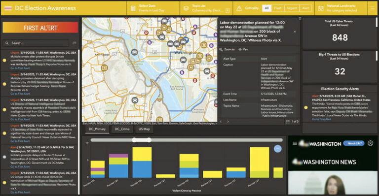
From public disorder to weather threats, real-time risk detection is critical. #ArcGISVelocity integrates Dataminr alerts into live dashboards—giving teams the insight they need to act fast and stay ahead. Read the article for details: ow.ly/28fe50WZIIN


📅 Heading to #EsriUC2025 in San Diego, July 14-18? Visit the #ArcGISVelocity and ArcGIS GeoEvent Server kiosks or join a session to get the latest on real-time #GIS. For details on each session and what to expect, check out this blog ➡️ ow.ly/Lcqr30sNZw2

Interested in real-time data monitoring? Discover how to utilize Arcade Track Functions in #ArcGISVelocity, a real-time app for #ArcGISOnline, for effective stream flow monitoring. Dive into our latest blog to learn more: esri.social/56vs50TqkJ7

Heading to #EsriUC2025 in San Diego, July 14-18? Visit the #ArcGISVelocity and #ArcGISGeoEvent kiosks or join a session to get the latest on real-time GIS. For details on each session and what to expect, check out our blog! Read more ➡️ ow.ly/HZWk50WfCRE

Join us at #FedGIS2025 to learn about advancements in #ArcGISVelocity, an extension for #ArcGISOnline, that brings powerful real-time capabilities for ingesting, analyzing, and disseminating critical information. Check out the real-time GIS sessions: ow.ly/pLKF50UST3q


Find out what’s new in #ArcGISVelocity. We have several exciting new capabilities and enhancements in this release! ☑️New output types (Amazon SNS, Amazon SQS, AWS IoT) ☑️New Create Range Fans tool ☑️And more! Explore blog: esri.social/eTst50OQXjW

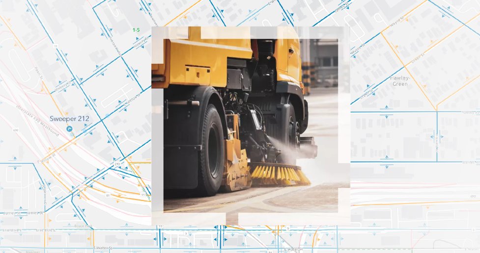
Clean streets are more than just beautiful—they're essential for safety and sustainability! Discover Esri’s Street Sweeping Operations solution to improve your community's appeal & safety. Learn about #ArcGISVelocity, a real-time app for #ArcGISOnline: esri.social/TwEw50Trp1A

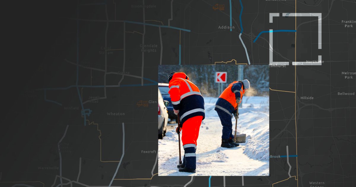
City of Syracuse is tracking snowplows during winter events with a GIS-powered solution called Winter Weather Operations. Using #ArcGISVelocity on #ArcGISOnline, it improves road safety, reduces costs, and provides real-time snow removal info: ow.ly/w0Ut50UICwW

Enhance street-sweeping operations with #ArcGIS Solutions and #ArcGISVelocity, an app for #ArcGISOnline! Streamline planning of sweeping schedules, centralize sweeper info, monitor real-time activity, and share schedules with the public. Learn more: esri.social/RIwl50SSsyc
The new @Samsara feed type in #ArcGISVelocity streamlines connecting to your vehicle telematics into #ArcGISOnline. This powerful integration helps enhance public services, boost driver operational efficiency, and improve community safety. Read the story: esri.social/zT5T50TzlO8

Check out #ArcGISVelocity, the SaaS IoT app for #ArcGISOnline! Explore our top 3 insights in real-time GIS from the Esri UC. From seamless Esri partner data integration to innovative solution templates, dive into our key highlights. Learn more: esri.social/weMB50T87qv

Organizations implementing real-time solutions face an increasing challenge in collecting, analyzing, and storing growing amounts of real-time and historical data. Explore data retention in #ArcGISVelocity, an extension for #ArcGISOnline. Learn more: ow.ly/lcj750UY1pp


Clean streets are more than just beautiful—they're essential for safety and sustainability! Discover Esri’s Street Sweeping Operations solution to improve your community's appeal & safety. Learn about #ArcGISVelocity, a real-time app for #ArcGISOnline: ow.ly/lnSB50Tufj5

Organizations implementing real-time solutions face an increasing challenge in collecting, analyzing, and storing growing amounts of real-time and historical data. Explore data retention in #ArcGISVelocity, an extension for #ArcGISOnline. Learn more: ow.ly/kAzM50UZxWw

Discover the top three takeaways in real-time GIS from the 2024 #Esri UC! From Esri partner data integration to new solution templates, dive into our biggest takeaways from an amazing conference. Learn more ➡️ esri.social/QbhK50T8VX2 #ArcGIS #ArcGISVelocity

Detect and manage threats in real-time with #Esri's Watch Center. Improve incident response and info sharing using #ArcGISVelocity, an #ArcGISOnline app. Get started quickly with a pre-configured solution: esri.social/gRTJ50TG0vO
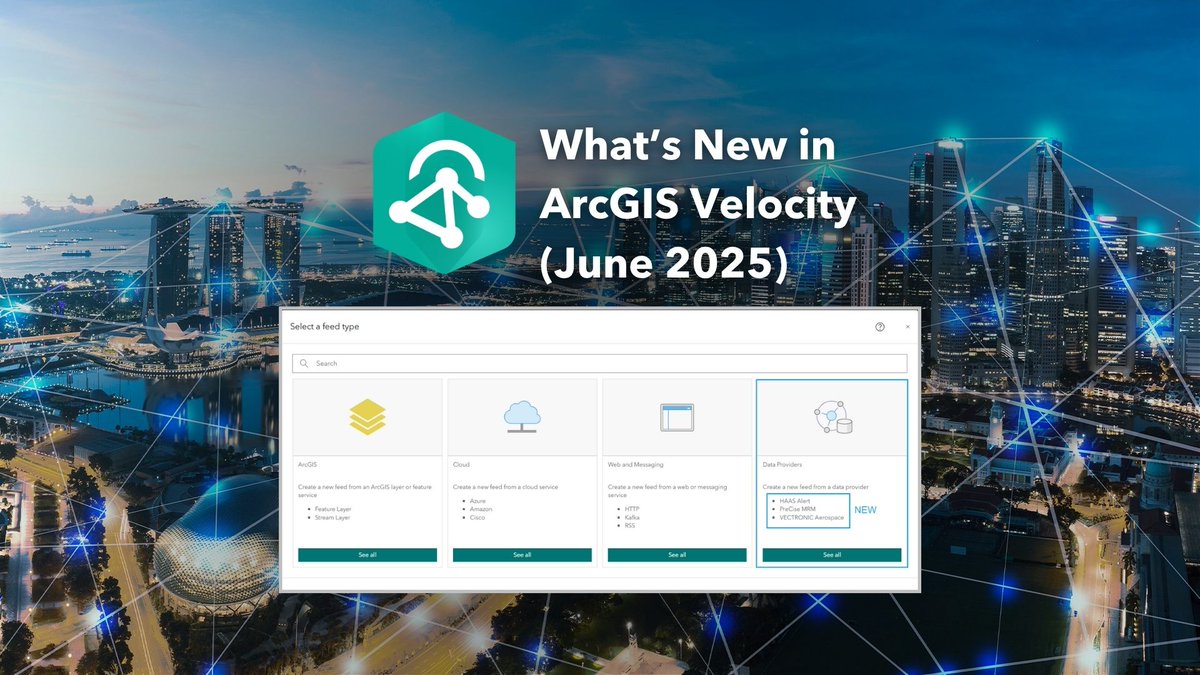
June 2025 update of #ArcGISVelocity introduces exciting new features and enhancements! A new integration with @trimble for data-driven work order automation, several new data provider feeds, and analytic tools. Get more details: ow.ly/18AS50WkuhJ
ArcGIS Velocity から Microsoft Teams への通知方法をご紹介! #ArcGIS #ArcgisVelocity #MicrosoftTeams #AdaptiveCard blog.esrij.com/?p=68000

ArcGIS Velocity から Microsoft Teams への通知方法をご紹介! |Esri Community Blog|[ community.esri.com/t5/a/a/ta-p/16… ] #ArcGIS #ArcgisVelocity #MicrosoftTeams #AdaptiveCard #地図 #GIS #サーバー
![ESRIJapan's tweet image. ArcGIS Velocity から Microsoft Teams への通知方法をご紹介!
|Esri Community Blog|[ community.esri.com/t5/a/a/ta-p/16… ]
#ArcGIS #ArcgisVelocity #MicrosoftTeams #AdaptiveCard
#地図 #GIS #サーバー](https://pbs.twimg.com/media/G6vD08vbEAAnFrj.jpg)
From public disorder to weather threats, real-time risk detection is critical. #ArcGISVelocity integrates #EsriPartner Dataminr alerts into live dashboards—giving teams the insight they need to act fast and stay ahead. Read the article 👇 ow.ly/JyYu50X12W3
From public disorder to weather threats, real-time risk detection is critical. #ArcGISVelocity integrates Dataminr alerts into live dashboards—giving teams the insight they need to act fast and stay ahead. Read the article for details: ow.ly/28fe50WZIIN

Organizations can now seamlessly stream AVL data from PreCise MRM directly into the #ArcGIS system with #ArcGISVelocity —unlocking real-time dashboards, alerts, and analytics for smarter, faster decisions. See how this integration transforms operations: ow.ly/ew4O50WVoPa
Stay ahead of winter weather with #ArcGIS! The Winter Weather Operations solution, powered by #ArcGISVelocity, helps develop response plans, monitor operations in real-time, share status updates, and track vehicle locations. Explore more: ow.ly/Ztmm50WPPwI
Real-time GIS took center stage at #EsriUC2025! Highlights include San Francisco Airport's use of #ArcGISVelocity to streamline runway ops, the new Transit On-Time Performance Solution, and Velocity announced a Beta for #ArcGISEnterprise. Learn more ➡️ ow.ly/qFyn50WCkwj
June 2025 update of #ArcGISVelocity introduces exciting new features and enhancements! A new integration with @trimble for data-driven work order automation, several new data provider feeds, and analytic tools. Get more details: ow.ly/18AS50WkuhJ
📅 Heading to #EsriUC2025 in San Diego, July 14-18? Visit the #ArcGISVelocity and ArcGIS GeoEvent Server kiosks or join a session to get the latest on real-time #GIS. For details on each session and what to expect, check out this blog ➡️ ow.ly/Lcqr30sNZw2
📅 Heading to #EsriUC2025 in San Diego, July 14-18? Visit the #ArcGISVelocity and #ArcGISGeoEventServer kiosks or join a session to get the latest on real-time GIS. For details on each session and what to expect, check out this blog ➡️ ow.ly/mNTz50WhLls

Heading to #EsriUC2025 in San Diego, July 14-18? Visit the #ArcGISVelocity and #ArcGISGeoEvent kiosks or join a session to get the latest on real-time GIS. For details on each session and what to expect, check out our blog! Read more ➡️ ow.ly/HZWk50WfCRE
The Search and Rescue Common Operating Platform (SARCOP) enhanced hurricane safety during Hurricanes Milton and Helene. #ArcGISVelocity was critical to providing a shared operational view for multiple agencies, improving coordination & resource allocation. ow.ly/Nr5Y30sL2nb

Last week at the Esri Developer & Technology Summit, Baron Weather delivered an impressive keynote presentation. They showcased a demo using #ArcGISVelocity to connect to real-time wind gust data, filter high winds, and send alerts. Learn more: ow.ly/FqG750VnBFS


The Search and Rescue Common Operating Platform (SARCOP) enhanced hurricane safety during Hurricanes Milton and Helene. #ArcGISVelocity was critical to providing a shared operational view for multiple agencies, improving coordination & resource allocation. ow.ly/YOVW30sKUgG

Last week at the Esri Developer & Technology Summit, Baron Weather delivered an impressive keynote presentation. They showcased a demo using #ArcGISVelocity to connect to real-time wind gust data, filter high winds, and send alerts. Learn more: ow.ly/9xGK50VkORt


At the #Esri Developer & Technology Summit, Baron #Weather delivered an impressive keynote presentation. They showcased a demo using #ArcGISVelocity to connect to #RealTime #wind gust data, filter high winds, & send alerts ow.ly/h6BZ50Vlo95 #GIS #ArcGIS #GPN #APWA
mediaspace.esri.com
Reimagining Your Weather Data for GIS Business Applications
The February 2025 update of #ArcGISVelocity will introduce new features and enhancements! Explore new real-time flight tracking with @FlightAware, hyperlocal weather data from @BaronWeather, and Microsoft Teams & Slack outputs for alerts. Learn more: ow.ly/iLta30sKJly

The February 2025 update of #ArcGISVelocity will introduce new features and enhancements! Explore new real-time flight tracking with @FlightAware, hyperlocal weather data from @BaronWeather, and Microsoft Teams & Slack outputs for alerts. Learn more: ow.ly/z5u150Vc0sa
esri.com
What's new in ArcGIS Velocity (February 2025)
The February 2025 release delivers access more feed types, output types, and analysis tools. Read this article to learn more about what's new.

🐑 From real-time data to real-time action: Discover how @NebraskaDOT is using #ArcGISVelocity and @Vectronics animal collars to transform Bighorn Sheep conservation. Read the case study here: ow.ly/qfAb50V5IUZ

From public disorder to weather threats, real-time risk detection is critical. #ArcGISVelocity integrates #EsriPartner Dataminr alerts into live dashboards—giving teams the insight they need to act fast and stay ahead. Read the article 👇 ow.ly/JyYu50X12W3
Interested in real-time data monitoring? Discover how to utilize Arcade Track Functions in #ArcGISVelocity, a real-time app for #ArcGISOnline, for effective stream flow monitoring. Dive into our latest blog to learn more: esri.social/56vs50TqkJ7
Heading to #EsriUC2025 in San Diego, July 14-18? Visit the #ArcGISVelocity and #ArcGISGeoEvent kiosks or join a session to get the latest on real-time GIS. For details on each session and what to expect, check out our blog! Read more ➡️ ow.ly/HZWk50WfCRE
The new @Samsara feed type in #ArcGISVelocity streamlines connecting to your vehicle telematics into #ArcGISOnline. This powerful integration helps enhance public services, boost driver operational efficiency, and improve community safety. Read the story: esri.social/zT5T50TzlO8
Join us at #FedGIS2025 to learn about advancements in #ArcGISVelocity, an extension for #ArcGISOnline, that brings powerful real-time capabilities for ingesting, analyzing, and disseminating critical information. Check out the real-time GIS sessions: ow.ly/pLKF50UST3q
#ArcGISVelocity, a SaaS IoT app for #ArcGISOnline, supports real-time data from trusted Esri partners or your own systems. Sensor data, weather feeds, incidents, social media streams—Velocity handles it all. Explore partners and data providers: esri.social/uoTK50Sis0H

Clean streets are more than just beautiful—they're essential for safety and sustainability! Discover Esri’s Street Sweeping Operations solution to improve your community's appeal & safety. Learn about #ArcGISVelocity, a real-time app for #ArcGISOnline: esri.social/TwEw50Trp1A
Enhance street-sweeping operations with #ArcGIS Solutions and #ArcGISVelocity, an app for #ArcGISOnline! Streamline planning of sweeping schedules, centralize sweeper info, monitor real-time activity, and share schedules with the public. Learn more: esri.social/RIwl50SSsyc
City of Syracuse is tracking snowplows during winter events with a GIS-powered solution called Winter Weather Operations. Using #ArcGISVelocity on #ArcGISOnline, it improves road safety, reduces costs, and provides real-time snow removal info: ow.ly/w0Ut50UICwW
From public disorder to weather threats, real-time risk detection is critical. #ArcGISVelocity integrates Dataminr alerts into live dashboards—giving teams the insight they need to act fast and stay ahead. Read the article for details: ow.ly/28fe50WZIIN
Check out #ArcGISVelocity, the SaaS IoT app for #ArcGISOnline! Explore our top 3 insights in real-time GIS from the Esri UC. From seamless Esri partner data integration to innovative solution templates, dive into our key highlights. Learn more: esri.social/weMB50T87qv
June 2025 update of #ArcGISVelocity introduces exciting new features and enhancements! A new integration with @trimble for data-driven work order automation, several new data provider feeds, and analytic tools. Get more details: ow.ly/18AS50WkuhJ
#Python でリアルタイム解析を監視!開発者必見の #ArcGISVelocity × #ArcGISNotebooks 活用術🔍 |Esri Community Blog| [community.esri.com/t5/documents/A…] #開発 #ArcGIS #リアルタイム解析
![ESRIJapan's tweet image. #Python でリアルタイム解析を監視!開発者必見の #ArcGISVelocity × #ArcGISNotebooks 活用術🔍
|Esri Community Blog| [community.esri.com/t5/documents/A…]
#開発 #ArcGIS #リアルタイム解析](https://pbs.twimg.com/media/F12x8PbagAAM7XT.png)
Find out what’s new in #ArcGISVelocity. We have several exciting new capabilities and enhancements in this release! ☑️New output types (Amazon SNS, Amazon SQS, AWS IoT) ☑️New Create Range Fans tool ☑️And more! Explore blog: esri.social/eTst50OQXjW
Get ready for #EsriUC2024! Explore a focused agenda highlighting real-time visualization and analytics activities. Stop by the expo to learn about #ArcGISVelocity, a cloud-native add-on for #ArcGIS Online. View the agenda: esri.social/zJN650Sxilw

Organizations implementing real-time solutions face an increasing challenge in collecting, analyzing, and storing growing amounts of real-time and historical data. Explore data retention in #ArcGISVelocity, an extension for #ArcGISOnline. Learn more: ow.ly/lcj750UY1pp
Detect and manage threats in real-time with #Esri's Watch Center. Improve incident response and info sharing using #ArcGISVelocity, an #ArcGISOnline app. Get started quickly with a pre-configured solution: esri.social/gRTJ50TG0vO
🐑 From real-time data to real-time action: Discover how @NebraskaDOT is using #ArcGISVelocity, an extension for #ArcGISOnline, and @Vectronics animal collars to transform Bighorn Sheep conservation. Read the case study here: ow.ly/2Fep50UY1qc

Strengthen your organization's safety and security with #real-time, all-hazard monitoring. Watch Center, powered by #ArcGISVelocity, a real-time app for #ArcGISOnline, consolidates diverse threat and hazard feeds, providing timely alerts. Learn more: esri.social/oKa550T8SpV

Discover the top three takeaways in real-time GIS from the 2024 #Esri UC! From Esri partner data integration to new solution templates, dive into our biggest takeaways from an amazing conference. Learn more ➡️ esri.social/QbhK50T8VX2 #ArcGIS #ArcGISVelocity
Something went wrong.
Something went wrong.
United States Trends
- 1. Treylon Burks 7,998 posts
- 2. Bo Nix 6,163 posts
- 3. #BaddiesUSA 13.5K posts
- 4. Mariota 4,365 posts
- 5. Broncos 21.5K posts
- 6. #RaiseHail 3,393 posts
- 7. #RHOP 8,516 posts
- 8. Chicharito 15.8K posts
- 9. Tomlin 23.4K posts
- 10. #Married2Med 2,490 posts
- 11. Steelers 62.4K posts
- 12. Riley Moss 1,165 posts
- 13. #ITWelcomeToDerry 10.3K posts
- 14. Bobby Wagner N/A
- 15. Mark Stoops 5,156 posts
- 16. Collinsworth 1,118 posts
- 17. Vikings 36.7K posts
- 18. Chrisean 6,081 posts
- 19. Sean Payton N/A
- 20. Maxey 3,903 posts