#climper search results
Awesome.. My #Valdosta post was next. That 5.47 shows up nice on our #CLIMPER map.. sercc.oasis.unc.edu/Map.php?date=2…

30°'s(39°) all the way down to @PuntaGordaAir yesterday. Here are the maps of some of the Max T, Min T, & Mean T. ranks from #CLIMPER. sercc.oasis.unc.edu/Map.php?date=2… @NWSKeyWest @NWSMiami @NWSMelbourne @NWSTampaBay @NWSJacksonville @NWSTallahassee @NWSMobile @FLClimateCenter

#WinterIsComing kinda chill headed for the #southeast. Check out our #CLIMPER(Climate(Forecast) Perspective tool) that shows the potential morning lows on Tuesday. sercc.oasis.unc.edu/Map.php?date=2… @NWSSouthern @NWSEastern #southeastwx #cold

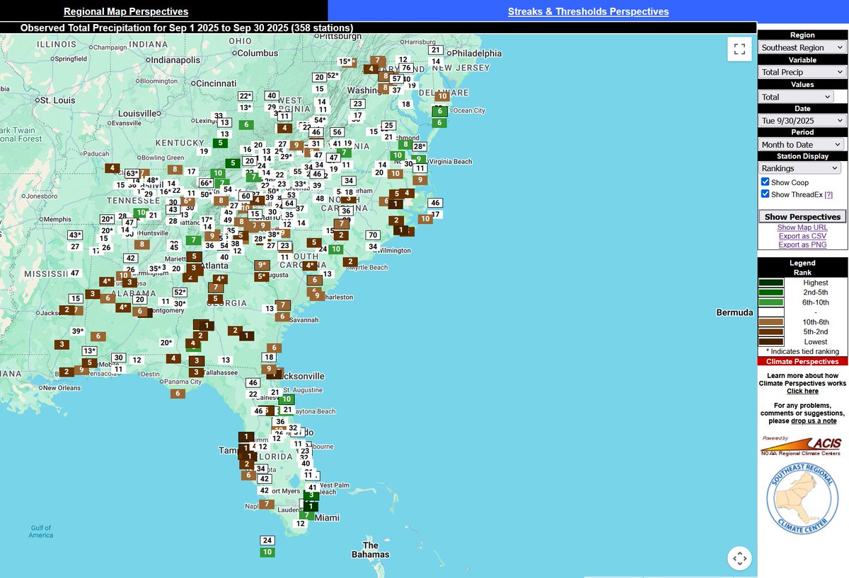
September #Rain ranks across the region from #CLIMPER.. sercc.oasis.unc.edu/Map.php?date=2… Our #MPE for the month can also be found here: sercc.com/precip-summary/ @FLClimateCenter @gaclimateoffice @NCSCO @mlgriffinWX1 @VirginiaClimate @NWSEastern @NWSSouthern @NOAADrought


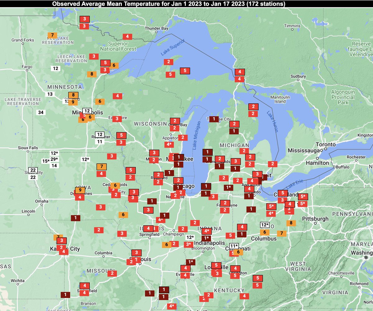
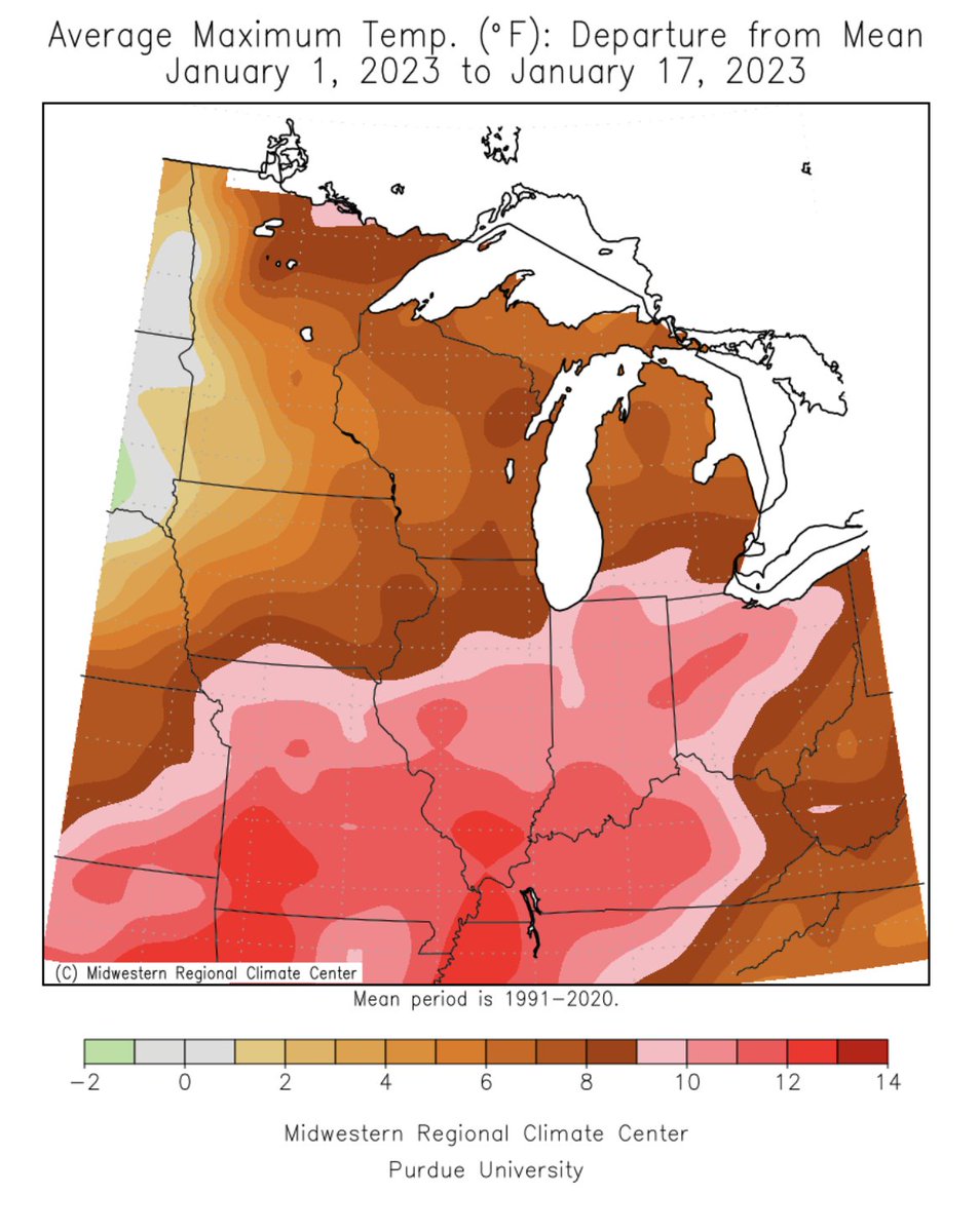
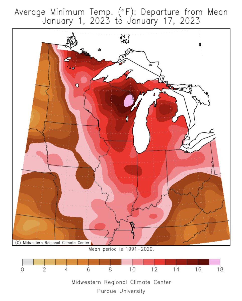
Record & near-record month-to-date temperatures have blanketed the Midwest to kick off January. Maps show Avg T ranks for Jan 1-17 (via #CLIMPER @SERCC) and MaxT & MinT departures for Jan 1-17 (via cli-MATE @MRCC). @NOAANCEI
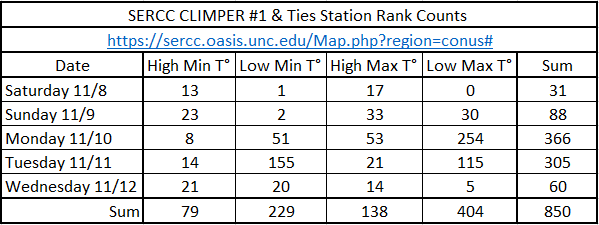
Using our #CLIMPER(Climate Perspective Tool) I counted up all the #1s and Ties for the #CONUS for the past 5 days. sercc.oasis.unc.edu/Map.php?region… @wxjerdman @NOAANCEI @NWSSouthern @NWSEastern @WeatherMatrix @capitalweather @FLClimateCenter @gaclimateoffice @VirginiaClimate @NCSCO
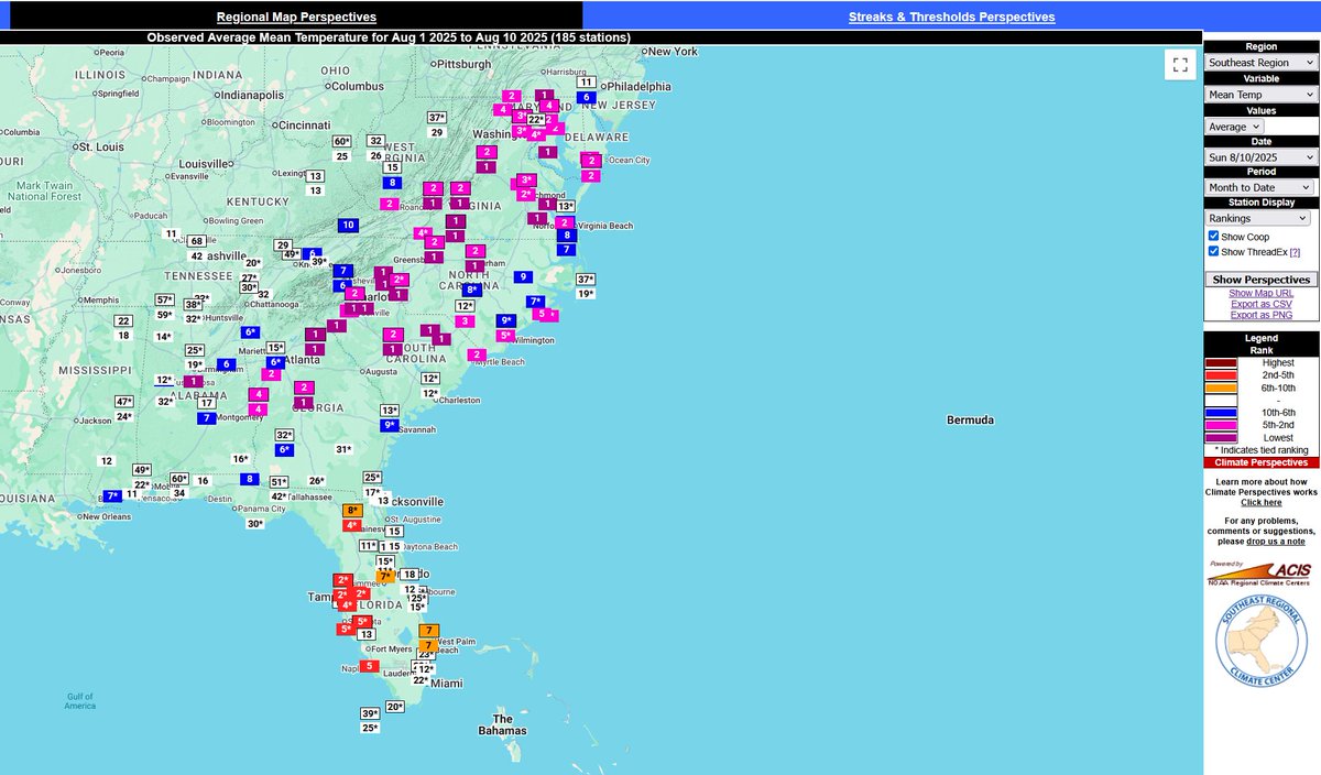
The First 10 days of August have been the coolest starts to the Month for many locations across our region. Except in parts of FL. @NWSEastern @NWSSouthern @NOAANCEI @gaclimateoffice @NCSCO @mlgriffinWX1 @FLClimateCenter sercc.oasis.unc.edu/Map.php?date=2… #CLIMPER
Love the Table @NWSEastern. Check out our #CLIMPER tool showing the same data in Map View for the #CONUS. sercc.oasis.unc.edu/Map.php?date=2… @NWSWestern @NWSSouthern @NWSCentral
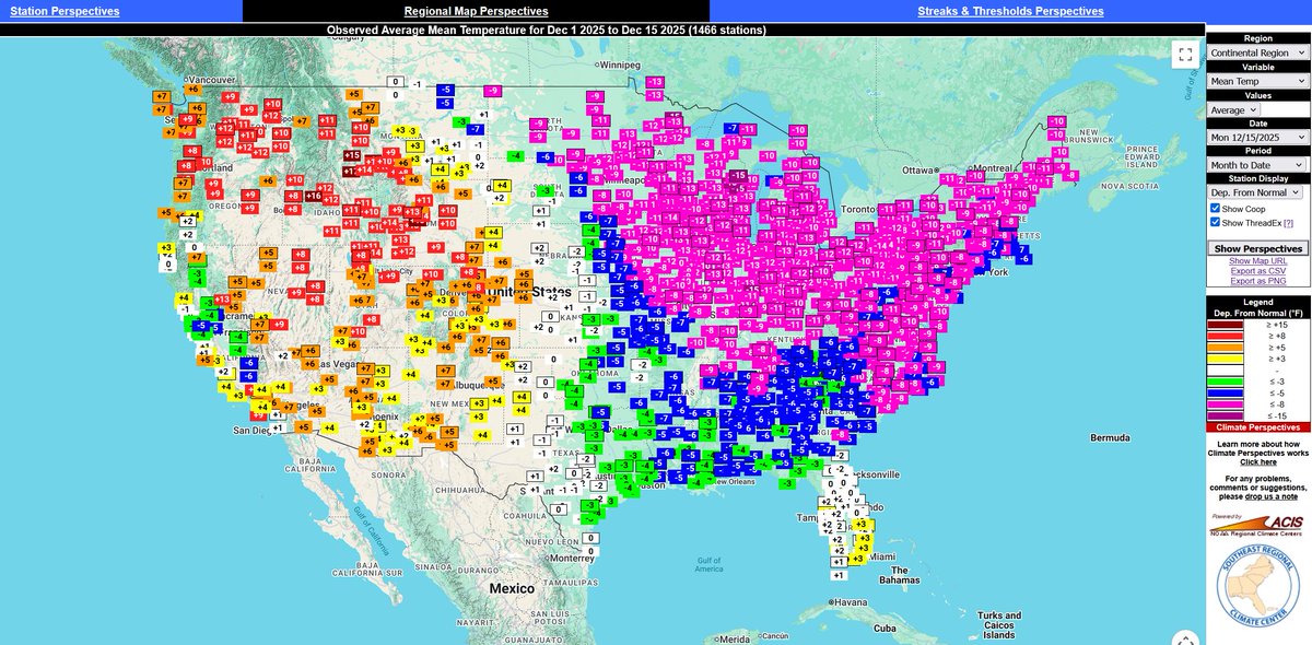
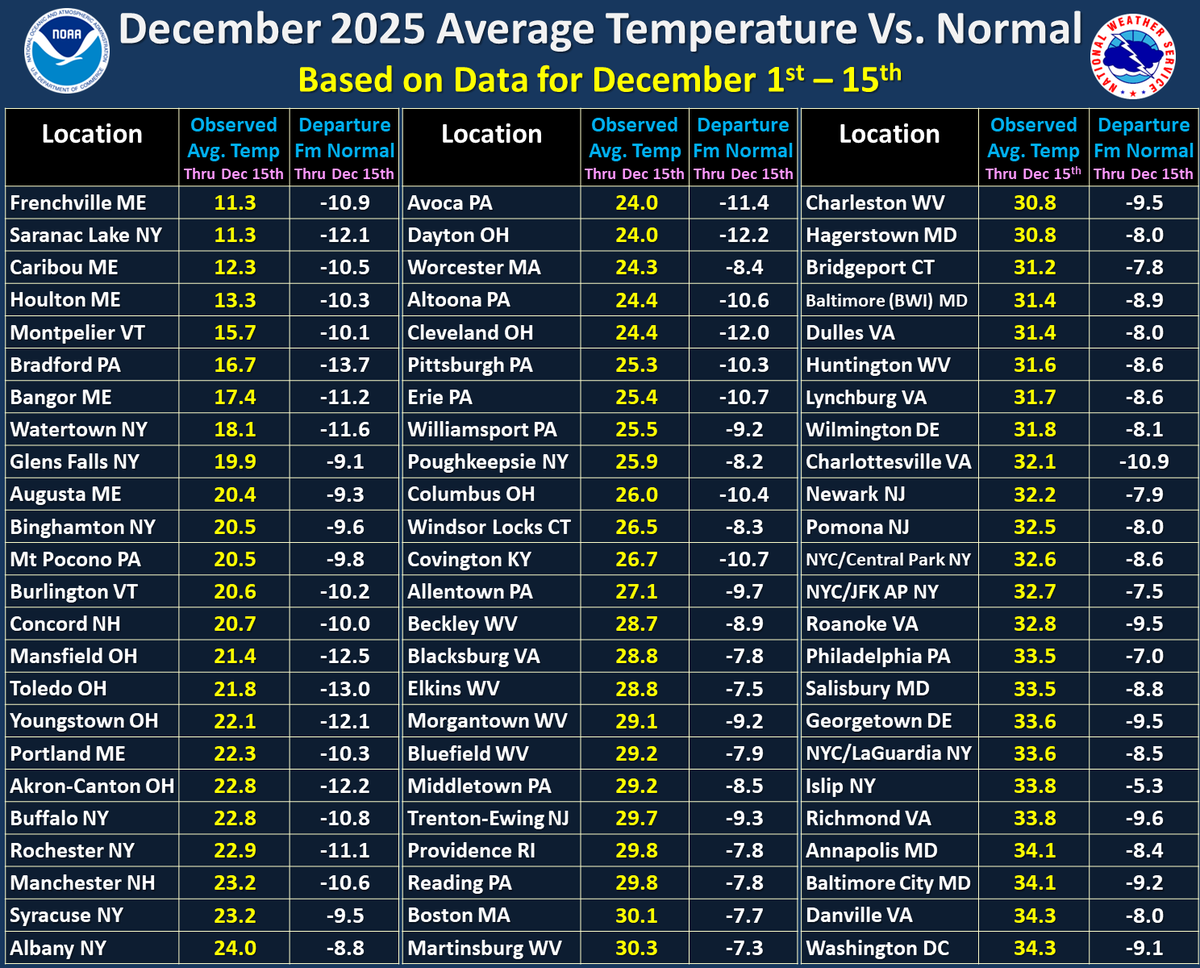
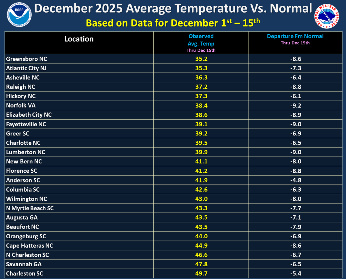
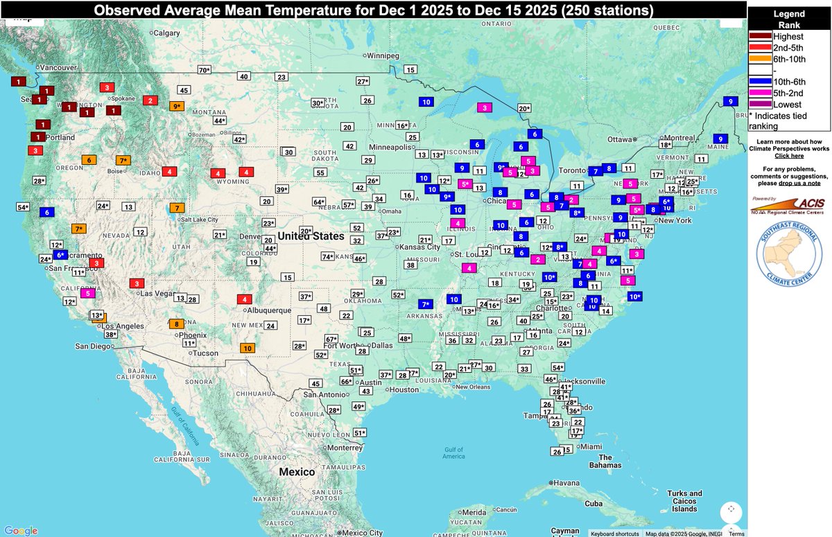
With the first 15 days of December over, here is a look at average temperatures so far for the month and how far they are below normal. We have seen below normal readings across the entire region, with many locations over 10 degrees below normal this month so far.
Very Impressive and look at this #Heat triangle between @NWSGSP @NWSAtlanta @NWSColumbia from our #CLIMPER map should Max Streak of 90°. sercc.oasis.unc.edu/Map.php?date=2… @mlgriffinWX1 @gaclimateoffice

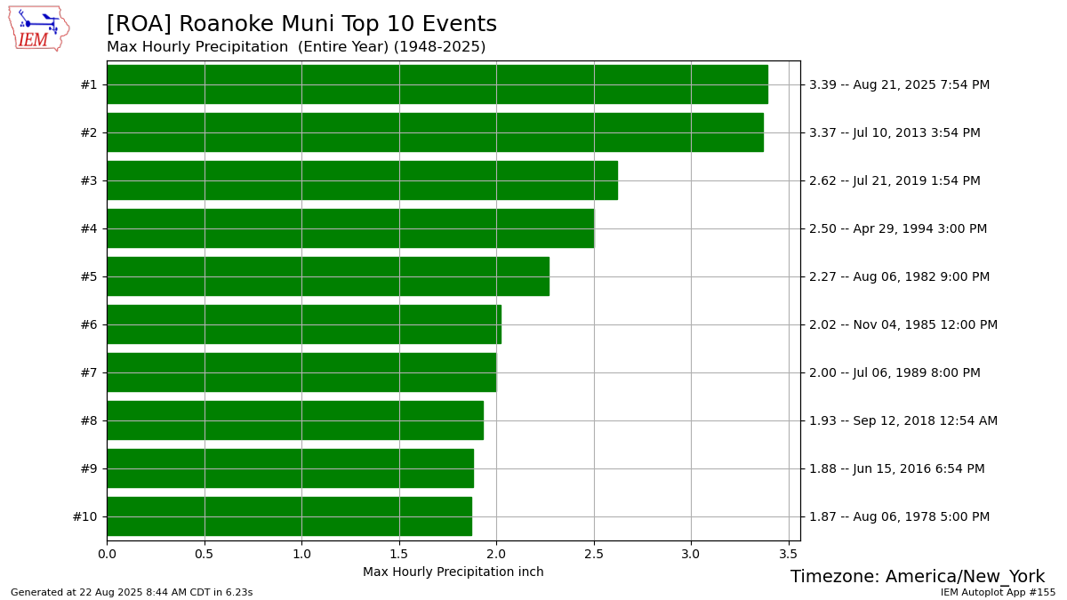
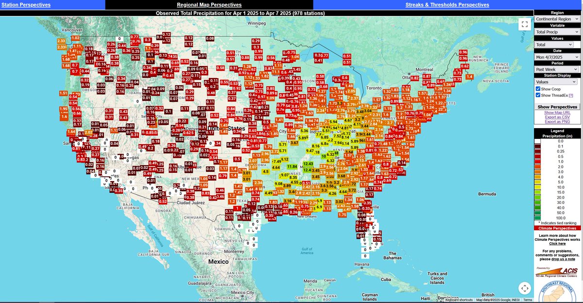
Noticed an impressive rain total on our #CLIMPER map this morning. 4.27 in. for @flyROA and 3.39 in. of that was recorded at the 7:54pm ob for the past hour and the wettest 1hr. total on record. @NWSBlacksburg #vawx @NOAANCEI

A few days remain in August but if you use our #ForecastPerspective feature in #CLIMPER you can see several top 5 values for coldest and warmest(In Florida) sercc.oasis.unc.edu/Map.php?date=2… @NWSSouthern @NWSEastern @NOAANCEI @FLClimateCenter @NCSCO @mlgriffinWX1 @gaclimateoffice

Awesome Perspective @WRAL_Michaels ... Here is what it looks like in #CLIMPER: sercc.oasis.unc.edu/Perspectives.p…

FUN FACT: Our past week has been comparable to late August/early September in Portland, OR. (According to @SERCC) A 2020 study shows that 49% of people in Oregon use central A/C. That number in NC is 84%.


EXP. N° 01901-2023-PHC/TC 10/5/2024 En el #CasoCocteles, la defensa de @KeikoFujimori y otros solicitaron a la Sala aplicar los efectos extensivos de la sentencia #Climper, FJ 7: «(...)b) efectos inter partes respecto de los fallos q se pronuncian sobre los procesos de HC(...)»
@wxjerdman did you use #CLIMPER(sercc.oasis.unc.edu/Map.php?date=2…) or something else.. The @NOAANCEI tool is runs a 10 day lag: ncdc.noaa.gov/cdo-web/datato…?
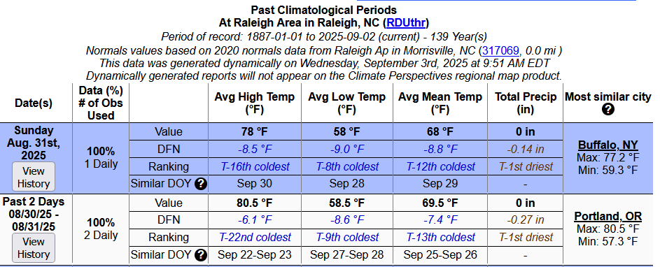
Our #CLIMPER(Climate Perspective Tool) has a feature called Similar DOY(Day of Year) and yesterday Halloween came early to @ATLairport. sercc.oasis.unc.edu/Perspectives.p… @GregPostel @JenCarfagno @gaclimateoffice @NWSAtlanta @NWSSouthern
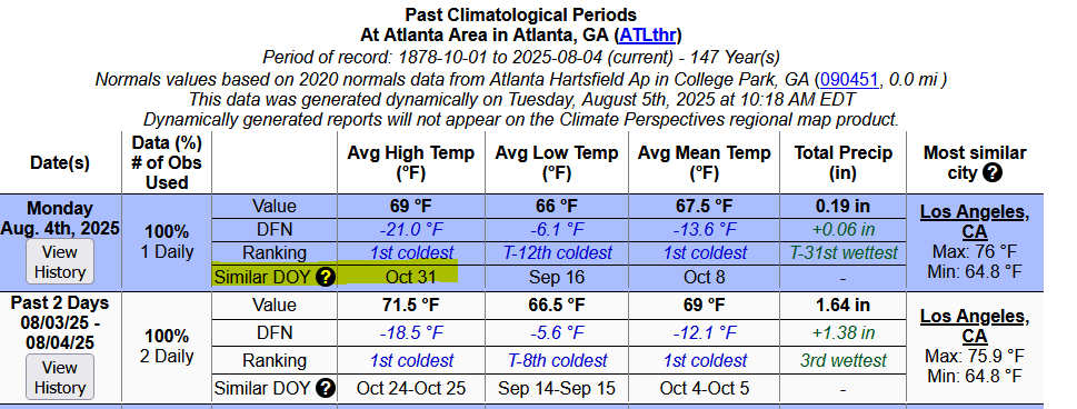
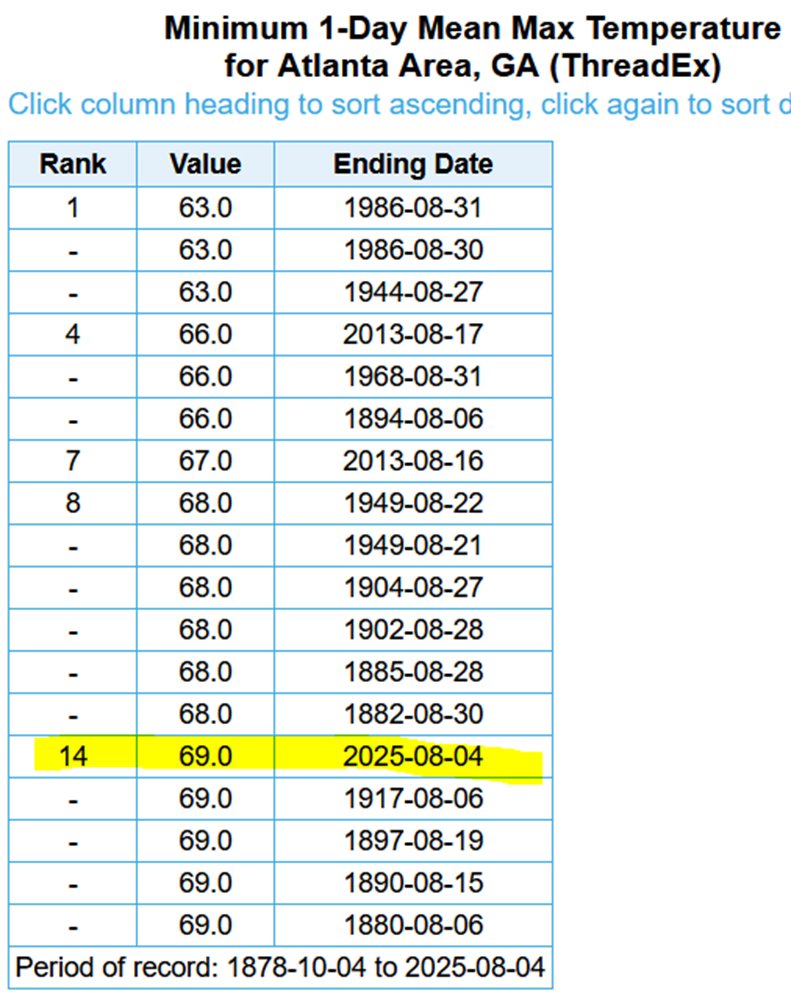
Check out those low highs in #Atlanta & #Athens ,#Georgia . Prior to 2013 & 2025 you have to go back to 1986 to find an August Max T. in the 60's. @NWSAtlanta @gaclimateoffice @NWSSouthern @NWSGSP @NWSColumbia @StephanieAbrams @JimCantore


Thanks @wxjerdman for the #CLIMPER plug.. Here is the URL for all your followers/viewers.. sercc.oasis.unc.edu/Map.php?date=2…


El @TC_Peru se volvió mesa de parte de sus jefes en el @congresoperu Libera a @VLADIMIR_CERRON Acepta recurso de #Climper Retorna a Benavides
Here is our #CLIMPER showing the #CONUS ranks. Check out @FLClimateCenter sercc.oasis.unc.edu/Map.php?date=2…
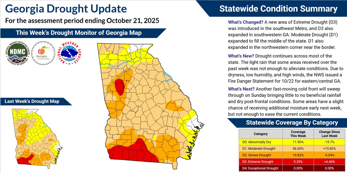
Check out the rain total so far this #fall(.29 in.)at @ATLairport. Only 1954(.28 in.) has recorded less through 10/22.. sercc.oasis.unc.edu/ClimPerList.ph… #CLIMPER @NWSAtlanta @gaclimateoffice @weatherchannel @NOAADrought @DroughtCenter

RT @f0urse4sons: อันนี้จะบ้านะ55555555 ทาร์ซานท้าว่าถ้าไลฟ์ได้ 5 แสนไลค์ จะโทรหาแอนนี่ (ที่นิวยอร์ก 7 โมงเช้า) แล้วอูชานบอก “ผมกลัวครับ ขอถ…

Perfect weekend for @Coventry_City Middlesbrough draw, Hull, Ipswich, Millwall all lost. Fantastic result at West Brom.


RT @mugheesali81: پاکستان کے ذمہ قرض اور واجبات کا حجم 138 ارب ڈالر سے بڑھ گیا، دستاویز میں کہا گیا ہے کہ 2022 کےمقابلے گزشتہ سال سود کی ا…


RT @WimdenOudsten: 𝗗𝗘 𝗚𝗥𝗢𝗢𝗧𝗦𝗧𝗘 𝗚𝗘𝗘𝗦𝗧𝗘𝗟𝗜𝗝𝗞𝗘 𝗠𝗔𝗡𝗜𝗣𝗨𝗟𝗔𝗧𝗜𝗘 𝗢𝗢𝗜𝗧: 𝗗𝗜𝗧 𝗜𝗦 𝗚𝗘𝗘𝗡 𝗧𝗢𝗘𝗩𝗔𝗟 Er gebeurt vandaag iets dat nog nooit eerder in de geschied…


RT @38divan: SON DAKİKA 🇨🇳 Çin, ABD'ye sert bir uyarıda bulundu 🇺🇸 "İran, Çin'in kırmızı çizgisidir. Herhangi bir ihlalin sonuçları olaca…

RT @avin585: 🚨 فوری : حکم اعدام #آرمین_اسدزاده اومده و میخوان بکشنش. خواهش میکنم رسانهای کنین. @POTUS #KingRezaPahlavi #IranMassac…


#Rain totals across the #CONUS using our #CLIMPER tool to start the month: sercc.oasis.unc.edu/Map.php?date=2… @MidwestClimate @NortheastRCC @srclimatecenter @HPClimateCenter @WRCCclimate @NOAANCEI @NWSSouthern @NWSEastern @NWSCentral @NOAADrought
Awesome.. My #Valdosta post was next. That 5.47 shows up nice on our #CLIMPER map.. sercc.oasis.unc.edu/Map.php?date=2…
Nice stat. @DonSuth89069583 @NWSTampaBay @FLClimateCenter sercc.oasis.unc.edu/Perspectives.p… #CLIMPER #ACIS


September #Rain ranks across the region from #CLIMPER.. sercc.oasis.unc.edu/Map.php?date=2… Our #MPE for the month can also be found here: sercc.com/precip-summary/ @FLClimateCenter @gaclimateoffice @NCSCO @mlgriffinWX1 @VirginiaClimate @NWSEastern @NWSSouthern @NOAADrought
@NbergWX using our #CLIMPER tool here are the MTD mean temp. Ranks across the U.S. sercc.oasis.unc.edu/Map.php?date=2…


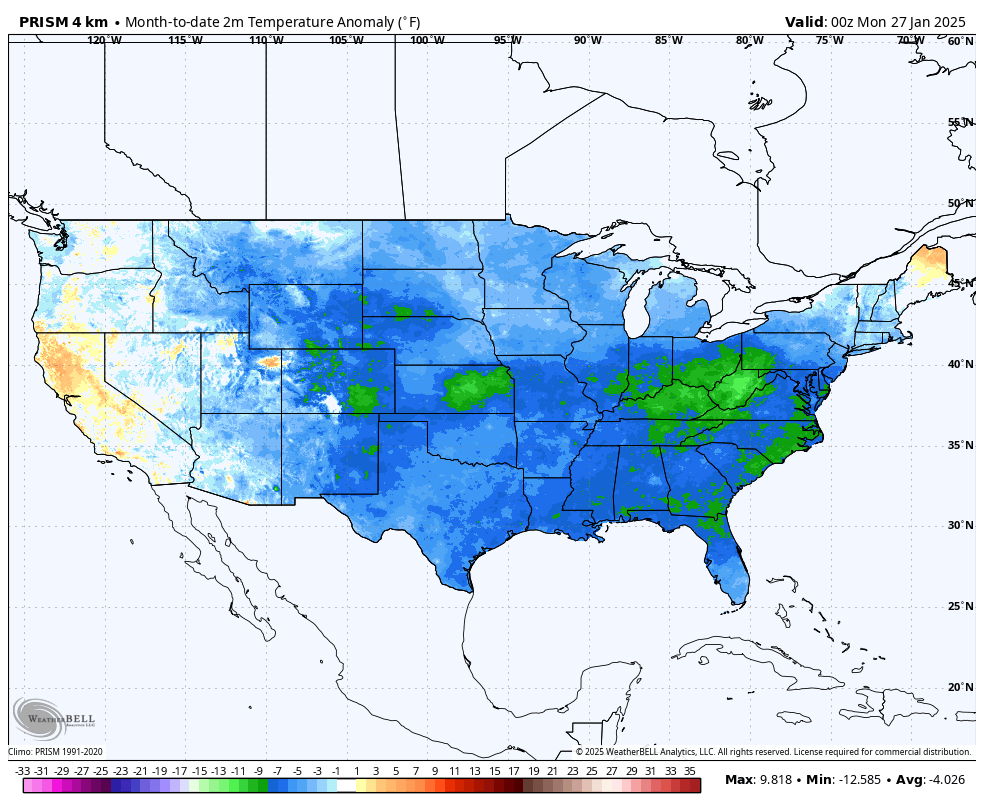
January 2025 currently the coldest January since 1988 averaged across all of America. Greatest cold anomaly below average.... West Virginia and Kentucky.
Very Impressive and look at this #Heat triangle between @NWSGSP @NWSAtlanta @NWSColumbia from our #CLIMPER map should Max Streak of 90°. sercc.oasis.unc.edu/Map.php?date=2… @mlgriffinWX1 @gaclimateoffice
#WinterIsComing kinda chill headed for the #southeast. Check out our #CLIMPER(Climate(Forecast) Perspective tool) that shows the potential morning lows on Tuesday. sercc.oasis.unc.edu/Map.php?date=2… @NWSSouthern @NWSEastern #southeastwx #cold
Record & near-record month-to-date temperatures have blanketed the Midwest to kick off January. Maps show Avg T ranks for Jan 1-17 (via #CLIMPER @SERCC) and MaxT & MinT departures for Jan 1-17 (via cli-MATE @MRCC). @NOAANCEI
Using our #ForecastPerspective page within #CLIMPER it looks like today is most Similar to @NWSEureka than @NWSRaleigh for @flyfrompti Although that 62° forecast high might be too high for today.. @NCSCO @NOAANCEI @katcampbellwx sercc.oasis.unc.edu/Perspectives.p…

Using our #CLIMPER(Climate Perspective Tool) I counted up all the #1s and Ties for the #CONUS for the past 5 days. sercc.oasis.unc.edu/Map.php?region… @wxjerdman @NOAANCEI @NWSSouthern @NWSEastern @WeatherMatrix @capitalweather @FLClimateCenter @gaclimateoffice @VirginiaClimate @NCSCO
30°'s(39°) all the way down to @PuntaGordaAir yesterday. Here are the maps of some of the Max T, Min T, & Mean T. ranks from #CLIMPER. sercc.oasis.unc.edu/Map.php?date=2… @NWSKeyWest @NWSMiami @NWSMelbourne @NWSTampaBay @NWSJacksonville @NWSTallahassee @NWSMobile @FLClimateCenter
The First 10 days of August have been the coolest starts to the Month for many locations across our region. Except in parts of FL. @NWSEastern @NWSSouthern @NOAANCEI @gaclimateoffice @NCSCO @mlgriffinWX1 @FLClimateCenter sercc.oasis.unc.edu/Map.php?date=2… #CLIMPER
Love the Table @NWSEastern. Check out our #CLIMPER tool showing the same data in Map View for the #CONUS. sercc.oasis.unc.edu/Map.php?date=2… @NWSWestern @NWSSouthern @NWSCentral
With the first 15 days of December over, here is a look at average temperatures so far for the month and how far they are below normal. We have seen below normal readings across the entire region, with many locations over 10 degrees below normal this month so far.
A few days remain in August but if you use our #ForecastPerspective feature in #CLIMPER you can see several top 5 values for coldest and warmest(In Florida) sercc.oasis.unc.edu/Map.php?date=2… @NWSSouthern @NWSEastern @NOAANCEI @FLClimateCenter @NCSCO @mlgriffinWX1 @gaclimateoffice
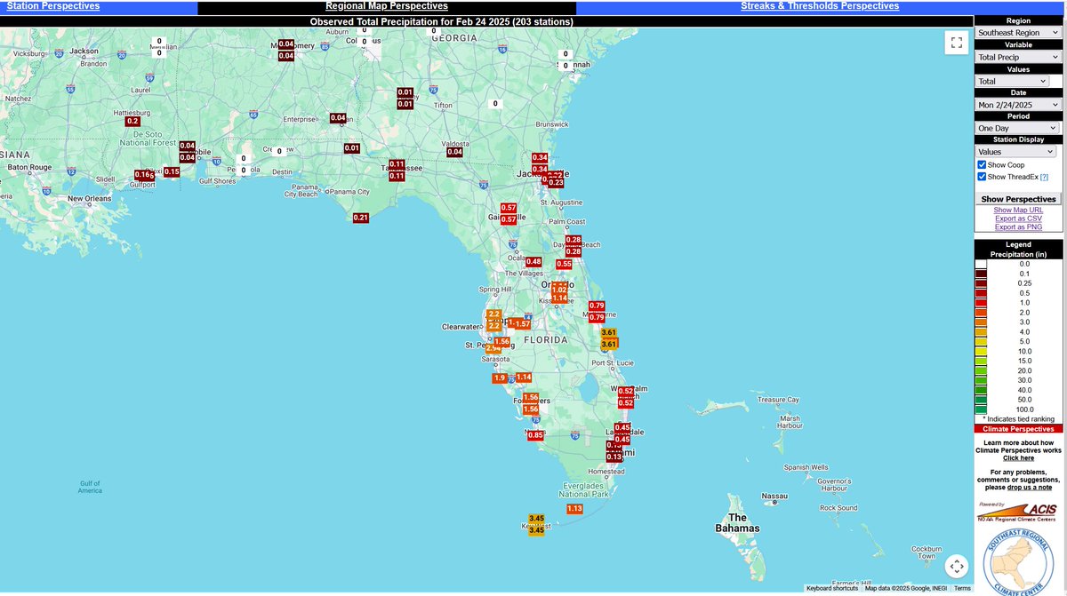
After another wet day for the @CityofSarasota & @SRQAirport their YTD deficit is now only -1.72 in. and on 5/31 it was at -5.21 in. Check out our #CLIMPER tool: sercc.oasis.unc.edu/Perspectives.p… @NWSTampaBay @FLClimateCenter @NWSSouthern @NOAANCEI

Noticed an impressive rain total on our #CLIMPER map this morning. 4.27 in. for @flyROA and 3.39 in. of that was recorded at the 7:54pm ob for the past hour and the wettest 1hr. total on record. @NWSBlacksburg #vawx @NOAANCEI
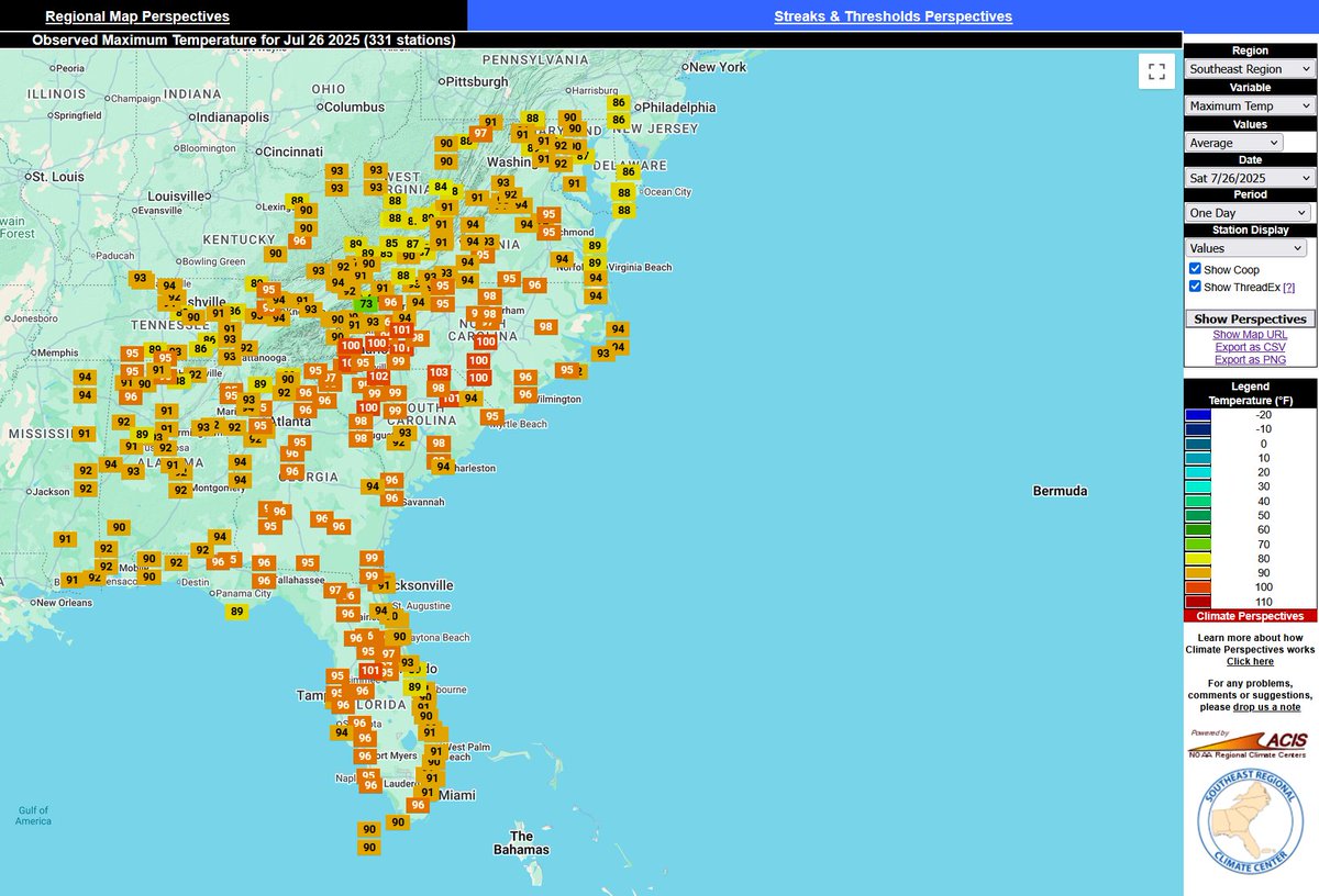
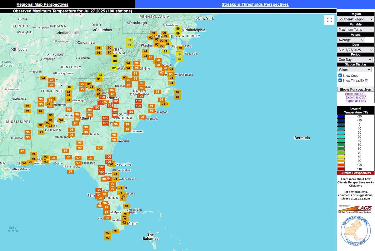
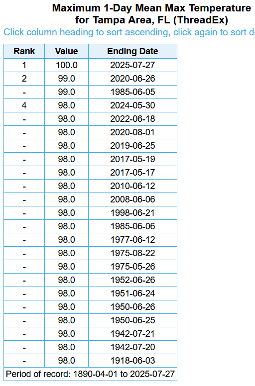
Like a broken record we will join in on welcoming @FlyTPA to the Century(100°) Club.. Also here are a few Max T. Maps from #CLIMPER from the weekend.. @NWSTampaBay @FLClimateCenter @NWSSouthern @NOAANCEI sercc.oasis.unc.edu/Map.php
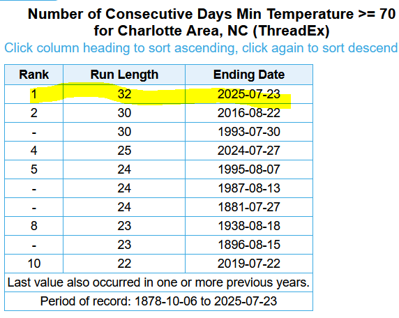
Well after a deeper look at Streaks in #CLIMPER it looks like @CLTAirport is now #1 for Days with Min. T.≥70°. sercc.oasis.unc.edu/Map.php?date=2… @wxbrad @NCSCO @NWSGSP @TimBuckleyWX @NOAANCEI @NWSEastern
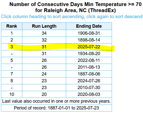
Yesterday's low of 68° at @RDUAirport ended a streak of 31 days with the low≥70°.. This is T-3 for longest streaks... @NWSRaleigh @NCSCO @NOAANCEI @TimBuckleyWX @WeatherWes @WRAL_Michaels @katcampbellwx @wralweather @NWSEastern
Impressive Rain Maker/Gulf Low across #Florida yesterday.. #CLIMPER @FLClimateCenter @NWSKeyWest @NWSMiami @NWSMelbourne @NWSTampaBay @wxmanvic sercc.oasis.unc.edu/Map.php?date=2…
Our #CLIMPER(Climate Perspective Tool) has a feature called Similar DOY(Day of Year) and yesterday Halloween came early to @ATLairport. sercc.oasis.unc.edu/Perspectives.p… @GregPostel @JenCarfagno @gaclimateoffice @NWSAtlanta @NWSSouthern
Check out those low highs in #Atlanta & #Athens ,#Georgia . Prior to 2013 & 2025 you have to go back to 1986 to find an August Max T. in the 60's. @NWSAtlanta @gaclimateoffice @NWSSouthern @NWSGSP @NWSColumbia @StephanieAbrams @JimCantore
Something went wrong.
Something went wrong.
United States Trends
- 1. Iran N/A
- 2. Israel N/A
- 3. Middle East N/A
- 4. Dubai N/A
- 5. Iraq N/A
- 6. Islamic N/A
- 7. IRGC N/A
- 8. Lamine N/A
- 9. Operation Epic Fury N/A
- 10. Ayatollah N/A
- 11. Death to America N/A
- 12. America First N/A
- 13. Netanyahu N/A
- 14. Burnley N/A
- 15. Strait of Hormuz N/A
- 16. War Powers Act N/A
- 17. Saudi Arabia N/A
- 18. Khamenei N/A
- 19. Bahrain N/A
- 20. Persian N/A