#isgappliedtechnology نتائج البحث

Preventing a rocky situation at a Wisconsin project site, #ISGAppliedTechnology installed a Robotic Total Station that takes measurements every 30 minutes to keep the project team informed of any rock movement. Check out how close the wall is to this building!😳#IngenuityAtWork

Our Des Moines office hosted ISG's annual Applied Technology Summit this week. The team spent two days digging into working group sessions and demonstrations to share new ideas and advance ISG's value-added technology services. Check it out! #ISGAllIn #ISGAppliedTechnology


Less time, less effort, and more data. Our 3D scanning technology allows our team to identify structural deficiencies and start designing a solution faster. Discover our advanced 3D scanning capabilities! #ISGAppliedTechnology #3DScanning
Enabling less risk, safer conditions, and high performing results, #ISGAppliedTechnology utilizes LiDAR technology to collect large amounts of highly accurate data in a short time frame. #IngenuityAtWork #Technology #LiDAR #AppliedTechnology

Capture. Document. Deliver. #ISGAppliedTechnology experts recently finished a project that captured 4.6 miles of modeled piping, using our High Density 3D Scanner! #IngenuityAtWork #3DScanning #Revit #PointCloudModeling #TrimbleX7


Using renderings to help stakeholders visualize the design and gain community support. #ISGAppliedTechnology experts used visualization technology to help give the community and District staff an idea of what the school would look like. #Visualization #ISGIowa #ISGEducation

Utilizing technology for even the most unique projects. Learn about how ISG recently partnered with the City of Clarion, Iowa to organize cemetery archives in this week's blog! #ISGAppliedTechnology #GIS #Technology #Archives #Blog blog.isginc.com/2021/12/08/whe…

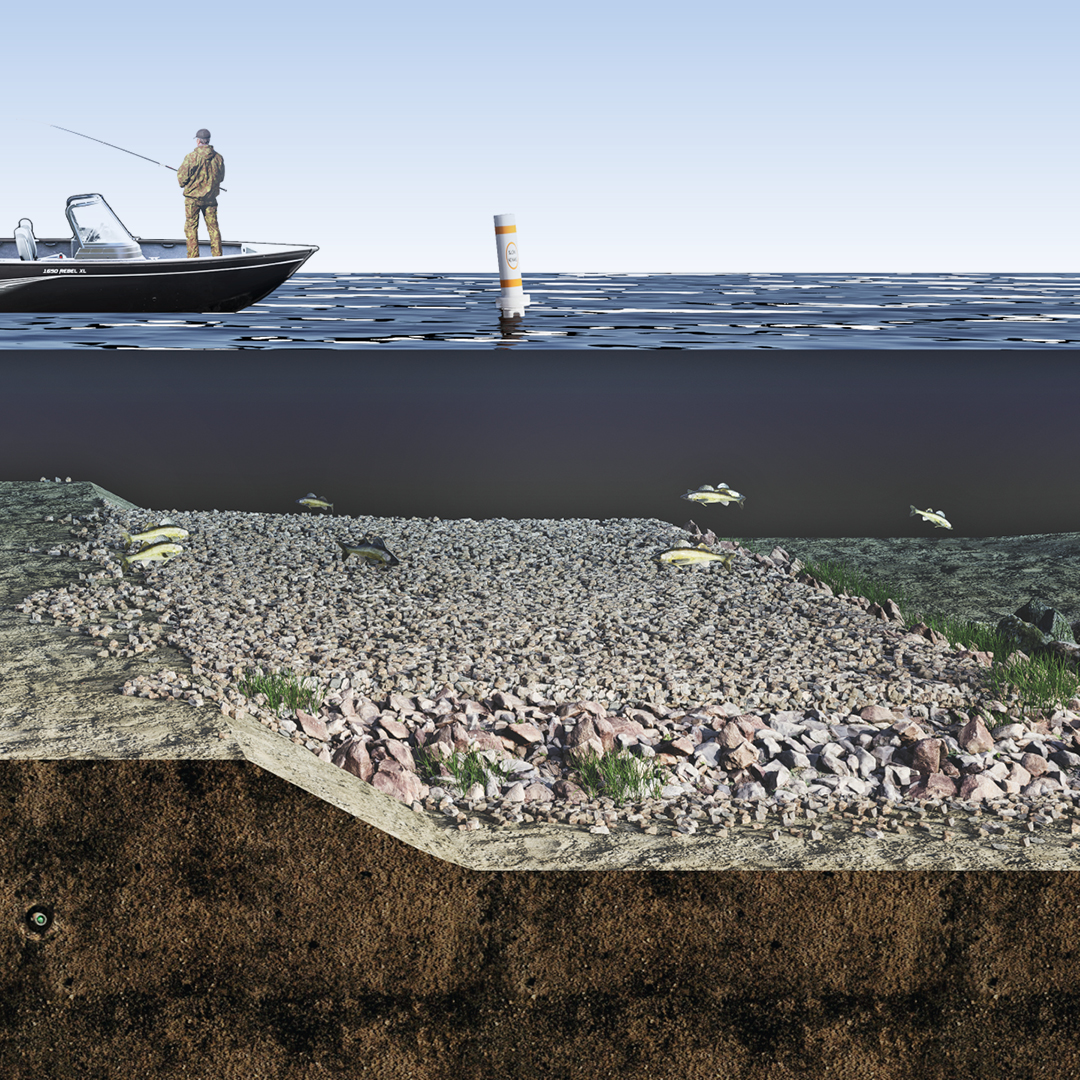
Visualizations for underwater environments? Yes, ISG can do that! Check out these unique visualization renderings for the Fountain Lake Habitat Restoration effort. #ISGAppliedTechnology #ISGWater #Visualizations #FountainLake brnw.ch/21wClff

Not all drones are alike. At ISG, our 20+ certified drone pilots capture everything from aerial project progress photography to water depth and thermal deficiencies. Read on to learn more about the technology and possibilities. #ISGAppliedTechnology fal.cn/3wdlj


ISG’s Transportation team uses LiDAR, thermal, photo, and other sensors to gather aerial and terrestrial images and detailed 3D maps of roadway and bridge assets, allowing for precise roadway design and fewer changes in the field. #ISGAppliedTechnology #LIDAR #ISGTransportation


Providing industry-leading technology, #ISGAppliedTechnology recently added the HyDrone to our technology fleet! Learn more about how this remote-controlled survey boat allows project teams to reach new depths! #ISGAppliedTechnology #HyDrone #Boat #Survey blog.isginc.com/2021/12/15/rea…

From critical wetlands, to essential utilities, we capture it all. ISG employs @Esri Field Maps and ArcGIS Pro for spot-on feature documentation. #ISGAppliedTechnology #GIS #FieldMaps #ArcGIS

Today we celebrate the high-tech application that routes us in the right direction–GIS! Discover how ISG leverages this industry leading tool. #GISDay #ISGAppliedTechnology #GIS #Applications brnw.ch/21wEtOK


How are you celebrating GIS Day?🤔At ISG, we celebrate every day by using the industry-leading Esri GIS software system to help our clients collect, analyze, and showcase geospatial data. Read more below! #NationalGISDay #GIS #ISGAppliedTechnology blog.isginc.com/2022/11/16/cel…

Identifying and measuring critical project elements not accessible with the human hand. Utilizing pipe crawling survey capabilities, ISG can provide in-depth and accurate investigative services for clients. #ISGAppliedTechnology #IngenuityAtWork youtu.be/4Y-WncUAm74
25 Minutes! That's all the time it took our applied technology team to capture the City of Winthrop, MN utility and street details for an improvement project. Take a quick tour to see the valuable 360-degree imagery. #ISGAppliedTechnology fal.cn/3zZzZ
Using ISG-generated geologic and topographic data, #ISGAppliedTechnology worked with Pilgrim’s Pride in Arcadia, WI on reducing the risk of rock falls at their facility. Check out the timelapse below that continually tracks the wall’s movement! #3DScanning youtu.be/d-2yXAAsPG0
Allowing for safe, non-intrusive analysis of existing structures, ISG’s 3D scanning technology can take assessment capabilities to a whole new level. #ISGAppliedTechnology #3DScanning #Technology #Innovative youtu.be/--8xUd94sXk
youtube.com
YouTube
3D Scanning Overview
A one-man portable catamaran designed for stability and ruggedness. ISG is excited to add the HyDrone to our Applied Technology services. Check it out! #ISGAppliedTechnology #IngenuityAtWork #Hydrographic #Survey youtu.be/iK62E4hYc2E
youtube.com
YouTube
HyDrone Boat Overview
Using a thermal-imaging camera, #ISGAppliedTechnology experts were able to use a drone to obtain images of overhead power lines in a safe and close manner. Check out the video below! #ThermalImaging #Drone #ISGWisconsin youtu.be/vV_tSEqXf4g
From critical wetlands, to essential utilities, we capture it all. ISG employs @Esri Field Maps and ArcGIS Pro for spot-on feature documentation. #ISGAppliedTechnology #GIS #FieldMaps #ArcGIS
Less time, less effort, and more data. Our 3D scanning technology allows our team to identify structural deficiencies and start designing a solution faster. Discover our advanced 3D scanning capabilities! #ISGAppliedTechnology #3DScanning
Today we celebrate the high-tech application that routes us in the right direction–GIS! Discover how ISG leverages this industry leading tool. #GISDay #ISGAppliedTechnology #GIS #Applications brnw.ch/21wEtOK
Visualizations for underwater environments? Yes, ISG can do that! Check out these unique visualization renderings for the Fountain Lake Habitat Restoration effort. #ISGAppliedTechnology #ISGWater #Visualizations #FountainLake brnw.ch/21wClff
25 Minutes! That's all the time it took our applied technology team to capture the City of Winthrop, MN utility and street details for an improvement project. Take a quick tour to see the valuable 360-degree imagery. #ISGAppliedTechnology fal.cn/3zZzZ
ISG’s Transportation team uses LiDAR, thermal, photo, and other sensors to gather aerial and terrestrial images and detailed 3D maps of roadway and bridge assets, allowing for precise roadway design and fewer changes in the field. #ISGAppliedTechnology #LIDAR #ISGTransportation
Not all drones are alike. At ISG, our 20+ certified drone pilots capture everything from aerial project progress photography to water depth and thermal deficiencies. Read on to learn more about the technology and possibilities. #ISGAppliedTechnology fal.cn/3wdlj
See this community's vision become a reality by taking a stroll through the newest animated visualization of @cityofappleton's Lundgaard Park! #ISGAppliedTechnology #Visualization #Animation #ISGSportsAndRecreation youtu.be/UQQkqePWvX0
youtube.com
YouTube
Lundgaard Park Fundraising Campaign Animation
Our Des Moines office hosted ISG's annual Applied Technology Summit this week. The team spent two days digging into working group sessions and demonstrations to share new ideas and advance ISG's value-added technology services. Check it out! #ISGAllIn #ISGAppliedTechnology
Bringing designs to life with cutting-edge 3D visualizations! Utilizing a new 3D Mesh product, #ISGAppliedTechnology experts are able to stitch images together to create more refined and impactful imagery. #ISGAppliedTechnology #Drone #Visualization #3D youtu.be/w_3vXMCLmaE
youtube.com
YouTube
Drone Services | 3D Mesh
How are you celebrating GIS Day?🤔At ISG, we celebrate every day by using the industry-leading Esri GIS software system to help our clients collect, analyze, and showcase geospatial data. Read more below! #NationalGISDay #GIS #ISGAppliedTechnology blog.isginc.com/2022/11/16/cel…
Preventing a rocky situation at a Wisconsin project site, #ISGAppliedTechnology installed a Robotic Total Station that takes measurements every 30 minutes to keep the project team informed of any rock movement. Check out how close the wall is to this building!😳#IngenuityAtWork
Using ISG-generated geologic and topographic data, #ISGAppliedTechnology worked with Pilgrim’s Pride in Arcadia, WI on reducing the risk of rock falls at their facility. Check out the timelapse below that continually tracks the wall’s movement! #3DScanning youtu.be/d-2yXAAsPG0
From identifying hot spots and performing energy audits to isolating leaks that reduce inspection time and labor, ISG utilizes thermal drone technology to provide clients with real-time results, fast. Learn more below! #ISGAppliedTechnology #Drone #Thermal youtu.be/m8mJlM9DNrY
Providing industry-leading technology, #ISGAppliedTechnology recently added the HyDrone to our technology fleet! Learn more about how this remote-controlled survey boat allows project teams to reach new depths! #ISGAppliedTechnology #HyDrone #Boat #Survey blog.isginc.com/2021/12/15/rea…
Utilizing technology for even the most unique projects. Learn about how ISG recently partnered with the City of Clarion, Iowa to organize cemetery archives in this week's blog! #ISGAppliedTechnology #GIS #Technology #Archives #Blog blog.isginc.com/2021/12/08/whe…
Enabling less risk, safer conditions, and high performing results, #ISGAppliedTechnology utilizes LiDAR technology to collect large amounts of highly accurate data in a short time frame. #IngenuityAtWork #Technology #LiDAR #AppliedTechnology
Allowing for safe, non-intrusive analysis of existing structures, ISG’s 3D scanning technology can take assessment capabilities to a whole new level. #ISGAppliedTechnology #3DScanning #Technology #Innovative youtu.be/--8xUd94sXk
youtube.com
YouTube
3D Scanning Overview
With the ability to observe complex angles and model surfaces safely, #ISGAppliedTechnolgy provides a game-changing view of the future with our drone services. Learn more below! #ISGAppliedTechnology #Drone #Visualization #ThermalImaging youtu.be/InUFfCKKncs
A one-man portable catamaran designed for stability and ruggedness. ISG is excited to add the HyDrone to our Applied Technology services. Check it out! #ISGAppliedTechnology #IngenuityAtWork #Hydrographic #Survey youtu.be/iK62E4hYc2E
youtube.com
YouTube
HyDrone Boat Overview
Something went wrong.
Something went wrong.
United States Trends
- 1. Good Thursday 25.8K posts
- 2. Happy Halloween Eve 1,559 posts
- 3. #PitDark N/A
- 4. Talus Labs 21.3K posts
- 5. #AskSRK 27.9K posts
- 6. Happy Friday Eve N/A
- 7. #thursdayvibes 2,734 posts
- 8. #thursdaymotivation 3,005 posts
- 9. Super Sentai 1,310 posts
- 10. #ThursdayThoughts 2,509 posts
- 11. Happy Birthday Kat 1,274 posts
- 12. Tomorrow is Halloween 2,222 posts
- 13. ARC Raiders 18.9K posts
- 14. Austin Reaves 70.6K posts
- 15. President Xi 98K posts
- 16. Thune 34.9K posts
- 17. $KITKAT 22.3K posts
- 18. Xi Jinping 67.5K posts
- 19. Chipotle 6,712 posts
- 20. Sudan 860K posts