#pix4dcloud ผลการค้นหา


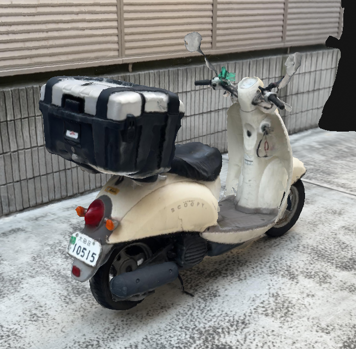
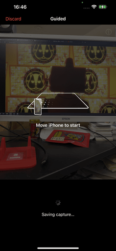
鍵をつけっぱで駐輪したんで戒めにモデリングしたけど、LumaAiだと狭くてうまくいかんかったな。撮影でまごまごしたら延々とSavingしとる。。 壁が近すぎ。 cloud.pix4d.com/dataset/139483… #Pix4Dcatch #Pix4Dcloud #LumaAi #GIVI #Honda んで、さっきまた会社で鍵つけっぱだった。。アホだな。
Pix4Dcloudのプロジェクト管理がマップベースにならんのが不思議でしょうがない。 #Pix4Dcloud

The Monument to the Partygoer in Malaga is a tribute to the Verdiales culture. 🕺 🇪🇸 1085 images captured with #PIX4Dcatch, processed on #PIX4Dcloud with #GaussianSplatting output. Digitally preserving cultural heritage! 🏛️ #3DMonday Try PIX4Dcatch: pix4d.com/product/pix4dc…

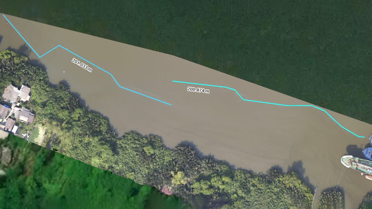
In this use case, coastal asset surveys are scanned with #PIX4Dcatch. Data goes to #PIX4Dcloud for tracking erosion & precise damage measurement from rising sea levels. This information empowers coastal authorities to make informed decisions. Read more: pix4d.com/blog/tracking-…

Upcoming workshop this May for #PIX4Dcatch & #PIX4Dcloud! 📱 ☁️ Learn best practices for RTK data capture & 3D reconstruction. Through hands-on exercises, you’ll explore everything from volume calculations to AR visualization. 🌐 📐 Spaces are limited: training.pix4d.com/courses/pix4dc…


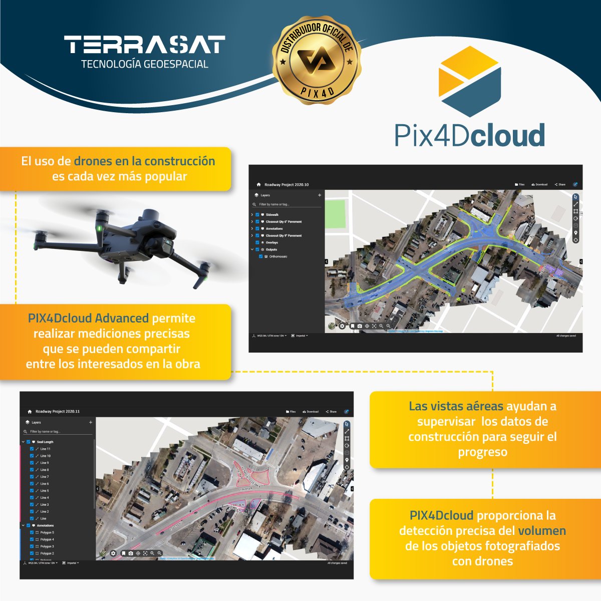
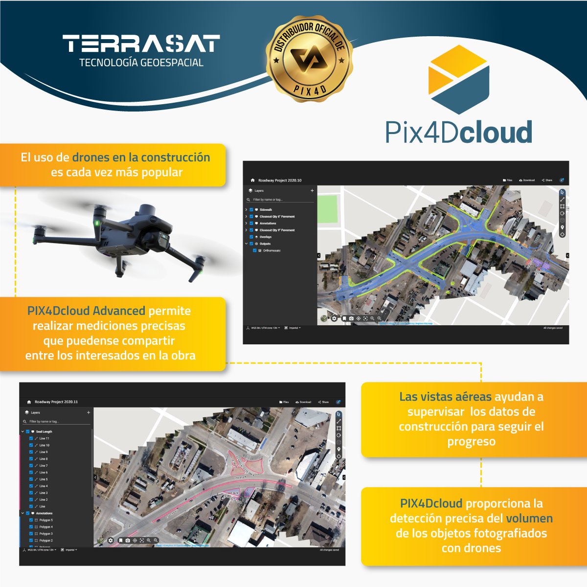
#pix4dcloud: El mapeo con #drone puede proporcionar datos sobre una obra sin detener o interrumpir las operaciones, ahorrando dinero y tiempo. Software de venta en #Terrasat #Pix4D #mapping #obracivil #Ingeniería #construcción #seguimientodeobra #videoaereo #fotografiaaerea


#PIX4Dmatic 1.64.0 #PIX4Dmapper 4.9 #PIX4Dcloud #PIX4Dfields 2.7 #PIX4Dreact 1.5.1 #PIX4Dsurvey 1.64.0 #PIX4DcapturePro 1.4.0 #PIX4Dcatch #SurveyDronesIreland

でっけぇなぁ。 これでも一部。半分いってねぇんでねぇかな?(適当) cloud.pix4d.com/site/230344/da… #阿蘇ドローン手形BIZ #Pix4Dcloud #VTOL
It's #3DMonday, and we're sharing a flythrough of the University of Bern captured by Pixmap. The 3D model was generated directly in #PIX4Dcloud without exchanging files, making the overall solution both lightweight and cost-effective! 💫 Try PIX4Dcloud: pix4d.com/product/pix4dc…
This #3DMonday, our submission shows the Old Iwabuchi Sluice Gate (Tokyo, Japan) using Gaussian Splatting on #PIX4Dcloud! 📷 Drone capture and 3D modeling by: Yachiyo Engineering Co., Ltd. Property management by: Ministry of Land, Infrastructure, Transport and Tourism (MLIT)
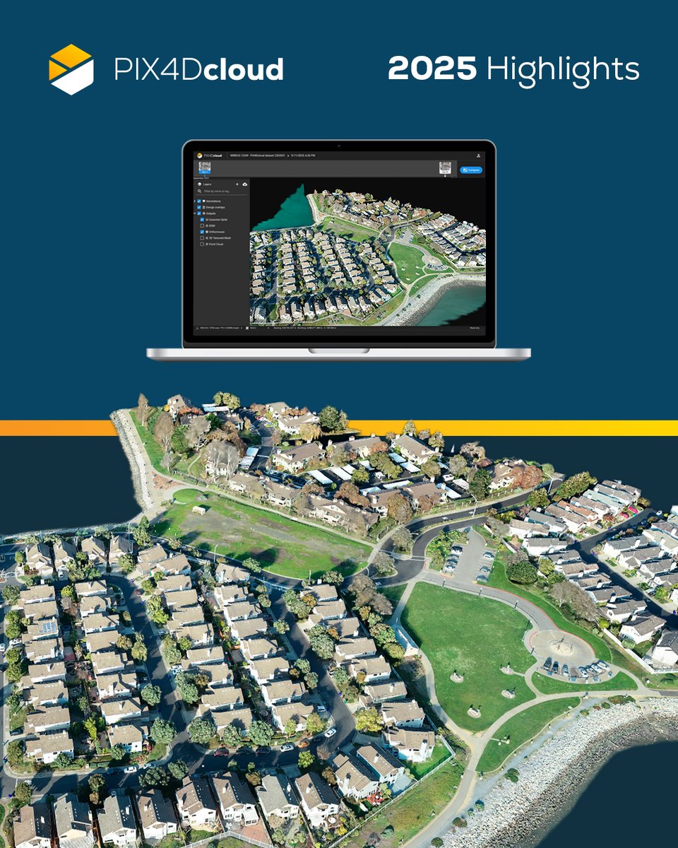
A landmark year for #PIX4Dcloud! 🎊 We scaled #georeferenced #GaussianSplatting from phone to drone projects in just one year, delivering measurable photorealism. 💫 Plus, Organization Management, enhanced #BIM/#GIS exports, & more! Full highlights: pix4d.com/blog/PIX4Dclou…
Upcoming workshop this May for #PIX4Dcatch & #PIX4Dcloud! 📱 ☁️ Learn best practices for RTK data capture & 3D reconstruction. Through hands-on exercises, you’ll explore everything from volume calculations to AR visualization. 🌐 📐 Spaces are limited: training.pix4d.com/courses/pix4dc…
In this use case, coastal asset surveys are scanned with #PIX4Dcatch. Data goes to #PIX4Dcloud for tracking erosion & precise damage measurement from rising sea levels. This information empowers coastal authorities to make informed decisions. Read more: pix4d.com/blog/tracking-…
This #3DMonday, we're taking a closer look at the details! 🔎 Mobile scanning app #PIX4Dcatch and cloud processing on #PIX4Dcloud let you turn everyday objects like this boat into precise, shareable 3D models. 🚤 Try PIX4Dcatch for yourself: pix4d.com/product/pix4dc…
The Monument to the Partygoer in Malaga is a tribute to the Verdiales culture. 🕺 🇪🇸 1085 images captured with #PIX4Dcatch, processed on #PIX4Dcloud with #GaussianSplatting output. Digitally preserving cultural heritage! 🏛️ #3DMonday Try PIX4Dcatch: pix4d.com/product/pix4dc…
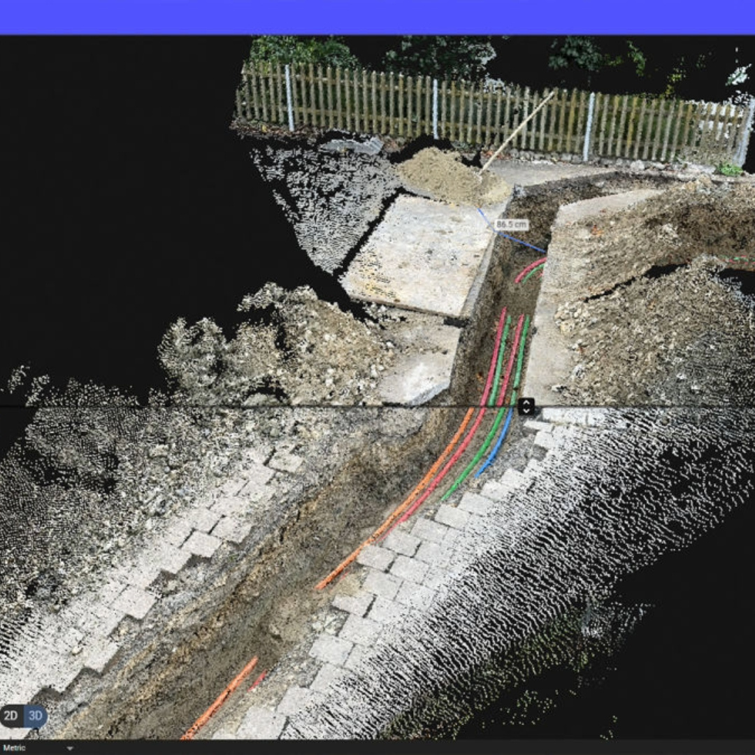
Did you know? 💡 You can now add high-resolution images directly from the field to points of interest placed by someone in the office! Enabling seamless collaboration via a mobile-to-cloud workflow. Watch our video to find out more! #PIX4Dcatch #PIX4Dcloud #construction #SUE

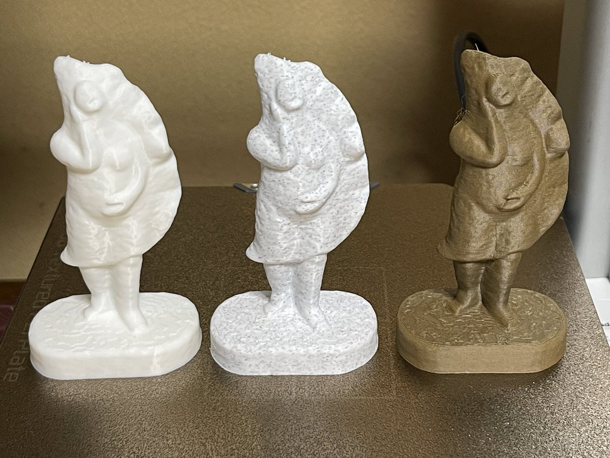
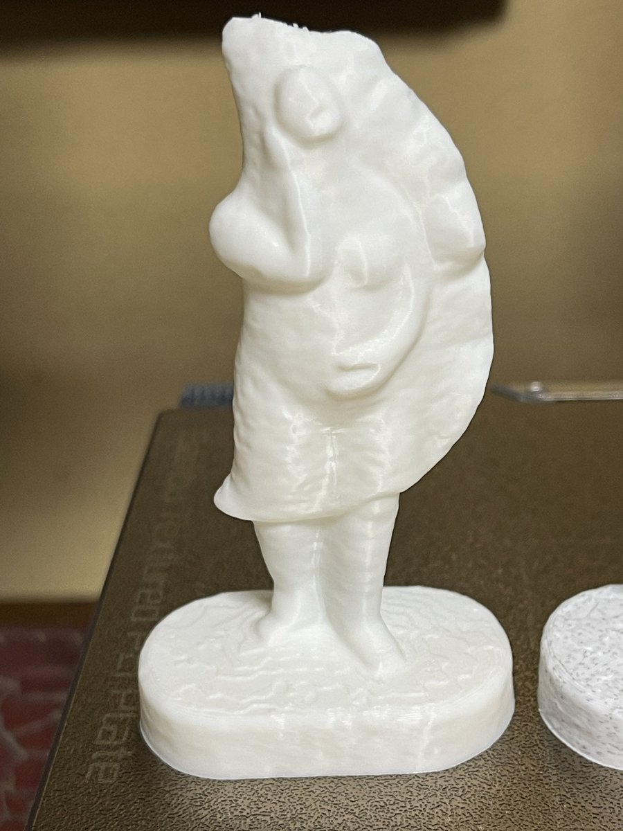
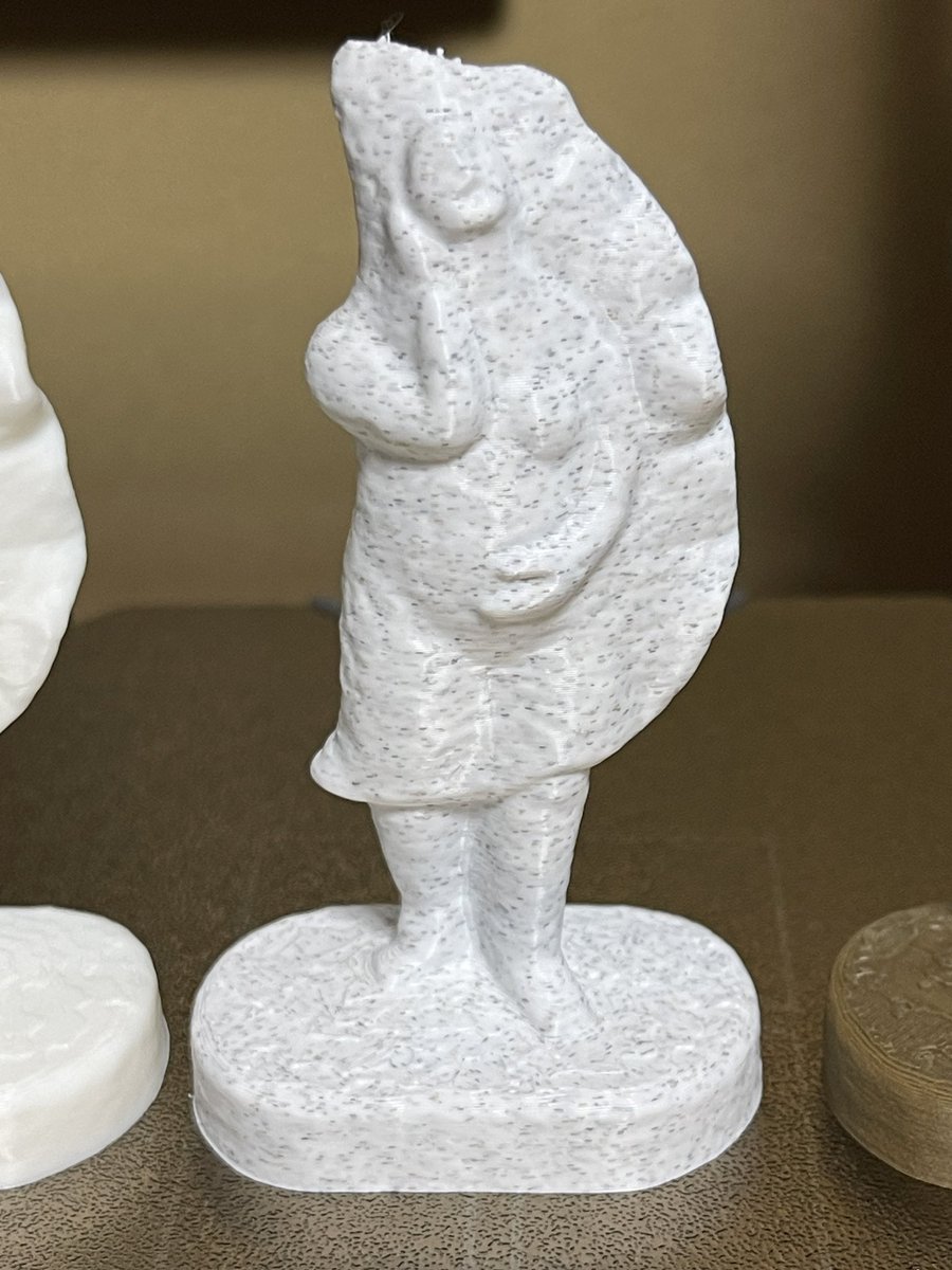
先日の出張で、出雲大社の入口近くに奉納されていた「親子ウサギ」像、3Dプリンティングまでしてみました。単色でプリントしたので、今度大学の講義の時にでも、若い学生の感性で「3D塗り絵」してもらおうかな、と思います。 #3DScanist #PIX4Dcatch #PIX4Dcloud #BambuStudio #A1mini #PLAmarble


📸わずか123枚の画像から高品質な3Dモデルを生成✨スペインのマラガ市にある「手相の鳥」像を #PIX4Dcatch で撮影、#PIX4Dcloud で処理、ガウススプラッティングで表示。見事な完成度です🐦 #Pix4D #GaussianSplatting
While on location in Malaga, our team stumbled across this unique statue—the Ave Quiromántica. With PIX4Dcatch, they generated this high-quality reconstruction, processed on #PIX4Dcloud from 123 images. 📸 The video showcases our #GaussianSplatting output. ✨ #3DMonday
Disputes are a common part of construction that many professionals aim to prevent. Discover how drone mapping, specifically with #PIX4Dcloud's timeline tool, helped save €80,000 (almost $100,000)! 💰 Read more here: pix4d.com/blog/solving-c… #digitalconstruction #bim

While on location in Malaga, our team stumbled across this unique statue—the Ave Quiromántica. With PIX4Dcatch, they generated this high-quality reconstruction, processed on #PIX4Dcloud from 123 images. 📸 The video showcases our #GaussianSplatting output. ✨ #3DMonday
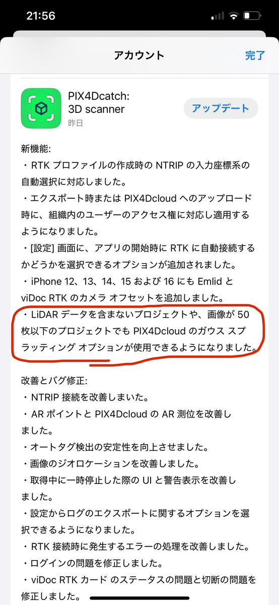
最新のアップデートでLiDAR非搭載端末でも処理できるようになってました! サーバ側もアップデートしてるのだと思います、多分。 3DGS、どんどん加速してますね! 要チェックですよー! #PIX4Dcatch #PIX4Dcloud #3Dガウシアンスプラッティング #3DGS
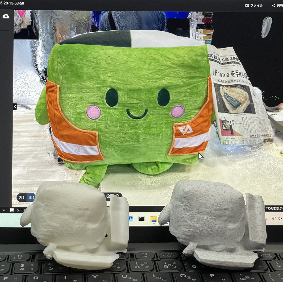
フィラメントの素材を変えるだけで、こんなにも印象が変わるのですね。 左から、「PLA Basic」「PLA Marble (石像っぽくなる?!)」「PLA Wood (木像っぽくなる?!)」 #餃子像 #PIX4Dcloud #BambuLab #A1mini


In this use case, nighttime #drone imagery was used to analyze light pollution, with a clear #orthomosaic processed in #PIX4Dcloud. 👏 Thanks to the Pix4D Support team for helping overcome the challenges of low-light data: pix4d.com/blog/drone-map…

📢 What’s new in #PIX4Dcatch, #PIX4Dmatic, and #PIX4Dcloud? 🆕 Highlights: • On-site annotations with PIX4Dcatch • Expanded #RTK support • Higher quality #mesh • New region-of-interest feature And more!! 🔗 Explore all the new features: pix4d.com/blog/improveme…
In a large-scale coastal cleanup effort, #dronemapping & #PIX4Dcloud were used to support the removal of over 10,000 kg of plastic waste from the ocean. Using drone imagery and volume calculations, they measured changes over time. Read more: pix4d.com/blog/ocean-cle…
After a major landslide in Colorado, Chinook Landscape Architecture used drone imagery and #PIX4Dcloud to generate accurate, shareable 3D models for geotechnical analysis: pix4d.com/blog/geohazard… #PIX4Dcloud #DroneMapping #Geohazards #3DModeling #Photogrammetry #GIS


PIX4Dcatchで撮影した、以前のデータを処理し直して、ガウススプラッティングで表示してみました。質感が良くなり滑らかになりました。 比較してみてください。 #pix4d #pix4dcatch #pix4dcloud #ガウススプラッティング #3dgs #ntgeotecs #エヴァンゲリオン #点群マニア
有明のSmall Worlds入口のエヴァンゲリオンを撮影してみました。オブジェをとるのが初めてで、上手くいっていない所があるのが反省的です。 #点群マニア #エヴァンゲリオン #smalkworlds

Curb heaves impact drainage, safety, and compliance. Accurate data creates maintainability. See how #PIX4Dcatch + Bad Elf Flex create a 3D curb profile in #PIX4Dcloud for better maintenance & #ADA planning. 📍 Learn more: [zurl.co/NE1IT ] #SmartCities @pix4d
In this use case, coastal asset surveys are scanned with #PIX4Dcatch. Data goes to #PIX4Dcloud for tracking erosion & precise damage measurement from rising sea levels. This information empowers coastal authorities to make informed decisions. Read more: pix4d.com/blog/tracking-…
Disputes are a common part of construction that many professionals aim to prevent. Discover how drone mapping, specifically with #PIX4Dcloud's timeline tool, helped save €80,000 (almost $100,000)! 💰 Read more here: pix4d.com/blog/solving-c… #digitalconstruction #bim
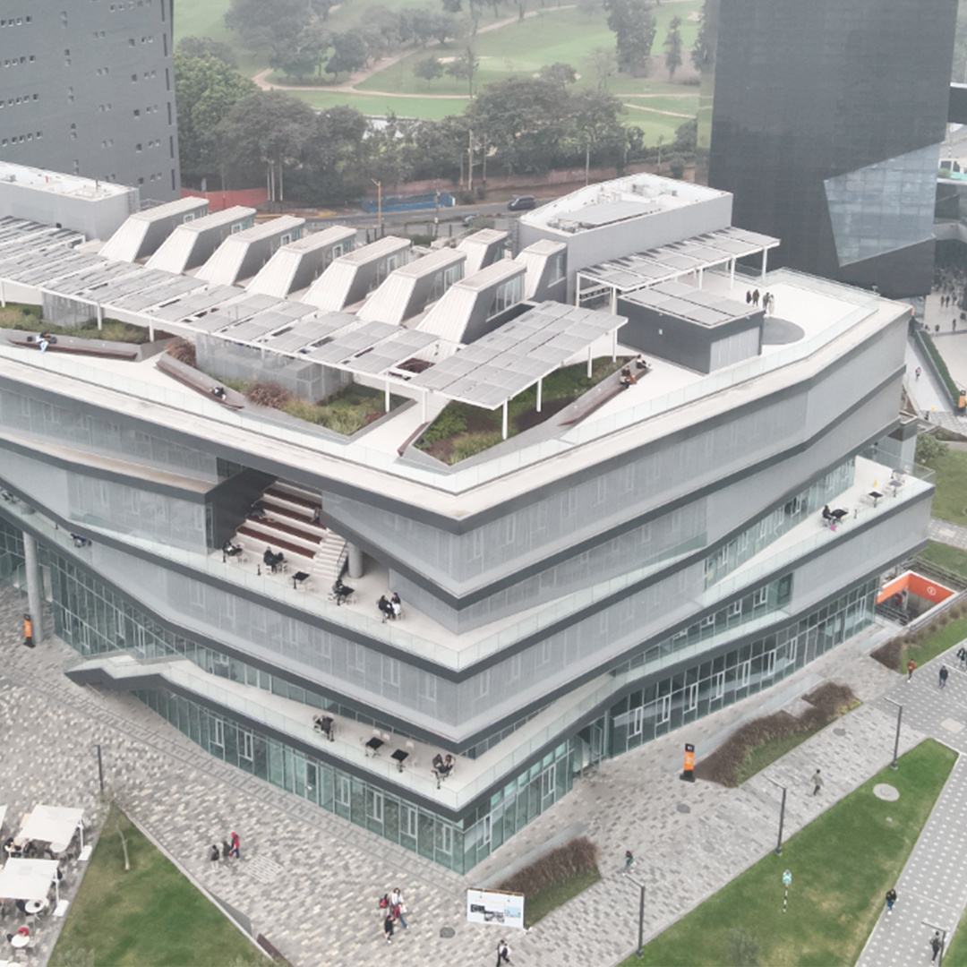
Exciting developments in Peru! 🎉 The University of Lima (@udelima) used #PIX4Dcloud for #DigitalConstruction. Using the software to monitor and accurately track the #construction of a renowned building on campus. Learn more here: hubs.li/Q02H3mcx0
鍵をつけっぱで駐輪したんで戒めにモデリングしたけど、LumaAiだと狭くてうまくいかんかったな。撮影でまごまごしたら延々とSavingしとる。。 壁が近すぎ。 cloud.pix4d.com/dataset/139483… #Pix4Dcatch #Pix4Dcloud #LumaAi #GIVI #Honda んで、さっきまた会社で鍵つけっぱだった。。アホだな。
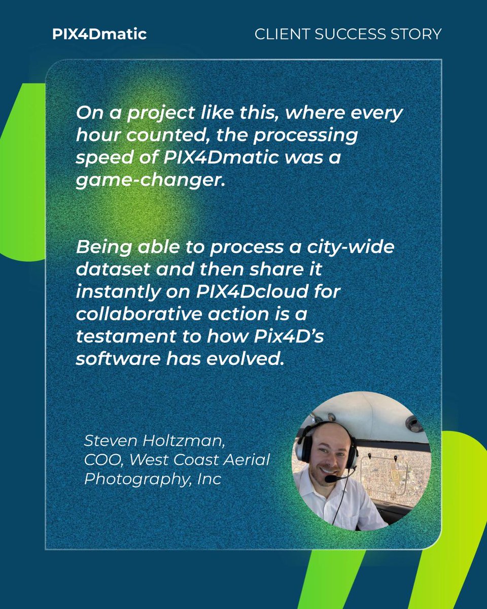
Do you have a large surveying project with a tight deadline? @westcoastaerial used #PIX4Dmatic to process an entire city-wide dataset, achieving a full 37 sq mi #survey and collaborative delivery via #PIX4Dcloud in under 24 hours. 🗺️ ✨ The full story: pix4d.com/blog/fighting-…
In this use case, a #construction company used #PIX4Dcloud to resolve a costly dispute. By documenting their site and utilizing the Timeline tool, they proved the issue wasn't their fault, saving up to €20,000 in repairs and securing new work: hubs.li/Q02RR1r60

A landmark year for #PIX4Dcloud! 🎊 We scaled #georeferenced #GaussianSplatting from phone to drone projects in just one year, delivering measurable photorealism. 💫 Plus, Organization Management, enhanced #BIM/#GIS exports, & more! Full highlights: pix4d.com/blog/PIX4Dclou…
The future of construction is digital! 💻 🌐 PIX4Dcloud is helping improve construction monitoring. With the digital timeline tool, track progress & ensure projects stay on schedule: pix4d.com/blog/PIX4Dclou… #pix4dcloud #pix4d #digitalconstruction

#pix4dcloud: El mapeo con #drone puede proporcionar datos sobre una obra sin detener o interrumpir las operaciones, ahorrando dinero y tiempo. Software de venta en #Terrasat #Pix4D #mapping #obracivil #Ingeniería #construcción #seguimientodeobra #videoaereo #fotografiaaerea
In a large-scale coastal cleanup effort, #dronemapping & #PIX4Dcloud were used to support the removal of over 10,000 kg of plastic waste from the ocean. Using drone imagery and volume calculations, they measured changes over time. Read more: pix4d.com/blog/ocean-cle…
📢 Online workshop alert! Master the full end-to-end Pix4D reality capture workflow! Three days of hands-on learning to guarantee accurate 2D maps and 3D models with the Pix4D ecosystem. 💫 Register now: training.pix4d.com/courses/pix4d-… #PIX4Dcatch #PIX4Dmatic #PIX4Dcloud #Pix4D

El mapeo con drones puede proporcionar datos sobre una obra sin detener o interrumpir las operaciones, ahorrando dinero y tiempo. Software de venta en #Terrasat #Pix4D #pix4dcloud #obras #obracivil #drone #Ingeniería #construcción #seguimientodeobra #videoaereo #fotografiaaerea
After a major landslide in Colorado, Chinook Landscape Architecture used drone imagery and #PIX4Dcloud to generate accurate, shareable 3D models for geotechnical analysis: pix4d.com/blog/geohazard… #PIX4Dcloud #DroneMapping #Geohazards #3DModeling #Photogrammetry #GIS
📽️ Check out our new #PIX4Dmatic video tutorials! 🌟 Learn how to: ➡️ Work with CRS ➡️ Add a region of interest ➡️ Process aerial data + terrestrial data ➡️ Merge aerial + terrestrial datasets and process with #PIX4Dcloud Watch here: hubs.li/Q02F_5jd0

In this use case, nighttime #drone imagery was used to analyze light pollution, with a clear #orthomosaic processed in #PIX4Dcloud. 👏 Thanks to the Pix4D Support team for helping overcome the challenges of low-light data: pix4d.com/blog/drone-map…
Capture data on-site with the #3DMobileScanning solution #PIX4Dcatch, and upload it to #PIX4Dcloud for processing. With PIX4Dcloud’s "compare mode," easily view before and after project images. Read more about this project here: hubs.li/Q02M3mjc0
Something went wrong.
Something went wrong.
United States Trends
- 1. Wyatt Sicks N/A
- 2. Invited Users N/A
- 3. Gen V N/A
- 4. Bo Dallas N/A
- 5. Nikki Cross N/A
- 6. Joe Gacy N/A
- 7. Zoey Stark N/A
- 8. Uncle Howdy N/A
- 9. Kay Lee Ray N/A
- 10. Chase U N/A
- 11. Alba Fyre N/A
- 12. The Boys N/A
- 13. #LightningStrikes N/A
- 14. Andre Chase N/A
- 15. Custom N/A
- 16. Jayden Reed N/A
- 17. FFXIV N/A
- 18. Betis N/A
- 19. Ray J N/A
- 20. Lucha Underground N/A