#pythongis search results

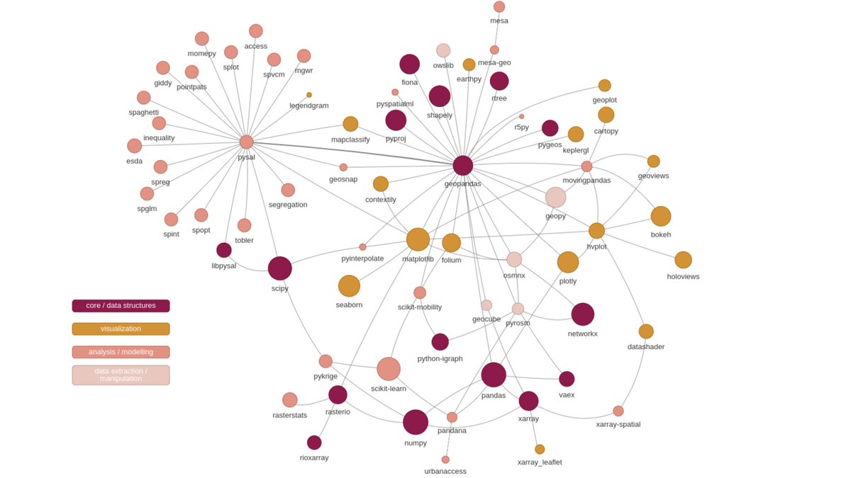
My first attempt to map the #GeoPython #PythonGIS ecosystem (currently n=69) for our @pythongis project (vector+raster) 🤓 𝐇𝐞𝐥𝐩 𝐧𝐞𝐞𝐝𝐞𝐝: What packages do I miss? I'm sure there are plenty of interesting libraries escaping my radar 🧐 @geopandas @pysal_devs @xarray_dev

Day 24: 📈 Time to trend with spatiotemporal data! Learn how Python libraries like SpacePy and PySAL analyze trends over time and space. Uncover patterns and insights in dynamic datasets. ⏰🌍 #SpatiotemporalAnalysis #PythonGIS

Day 28: 📡 Unleash the power of RADAR data in Python! Learn how libraries like Py-ART process and analyze RADAR data for weather, environmental, and geospatial applications. Decode the mysteries hidden in radio waves. 🌧️🌍 #RADARData #PythonGIS

Day 27: 🌐 Global reach with OGC standards! Learn how Python libraries like OWSLib enable seamless communication with geospatial web services adhering to Open Geospatial Consortium (OGC) standards. Foster interoperability in your GIS projects. 🤝🗺️ #OGCStandards #PythonGIS

Day 25: 🛰️ Space and Ground Unite! Dive into the fusion of satellite and ground-based data in Python. Leverage libraries like Skyfield to bridge the gap between celestial observations and geospatial analyses. 🌌🌍 Github Link: github.com/skyfielders/py… #SpaceData #PythonGIS


Tingkatkan keahlian Geospatial Analysis Anda! 🛰️ Dapatkan E-certificate, modul pelatihan, dan Zoom Live Session. Investasi hanya Rp125.000. JOIN US sekarang! Klik link di bawah! 🚀 s.id/PemetaanMangro… #PythonGIS #PemetaanLahan #MachineLearning #GeospatialAnalysis


#2 attempt to map the #GeoPython #PythonGIS ecosystem for our @pythongis project. Currently 123 libraries covering a broader spectrum of pkgs. Thanks a lot for everyone who answered the call and helped! 🙏😎 Will produce separate for vector+raster & interactive ones to play with.

My first attempt to map the #GeoPython #PythonGIS ecosystem (currently n=69) for our @pythongis project (vector+raster) 🤓 𝐇𝐞𝐥𝐩 𝐧𝐞𝐞𝐝𝐞𝐝: What packages do I miss? I'm sure there are plenty of interesting libraries escaping my radar 🧐 @geopandas @pysal_devs @xarray_dev

Diving into #GIS training it's clear: mastering Python is like unlocking a superpower! Python is the key to transforming raw geographic data into insightful, actionable information, from automating data analysis to creating dynamic maps. #PythonGIS #GeoSpatial"


🎯 Whether you're mapping cities, tracking climate, or managing resources — these tools power it all. 👉 Learn. Build. Solve. Explore more at sdssn.org #PythonGIS #SpatialAnalysis #GeoPython #SDSSN #GISCommunity
Day 3: 🌍 Mastering precision in GIS! Uncover the art of seamless coordinate transformations with the Pyproj library. Learn how to effortlessly convert between various coordinate reference systems for accurate geospatial analysis. 🌐 #GeoCoding #PythonGIS

6/6 There you have it—the top 5 Python GIS powerhouses of 2024! These tools democratize spatial data work. Which one's your fave, or did I miss one? Drop comments, RT for fellow coders, and follow for more threads! Let's discuss projects. 👇 #TechTips #PythonGIS
Top 5 Most Used Python Packages for GIS in 2024! If you're diving into geospatial analysis, mapping, or data viz, these libraries are game-changers. Based on community usage and mentions across sources, here's my rundown. Let's boost your skills! 🧵

Il nuovo Geobreak vi sta aspettando! Siamo pronti per voi, iniziamo tra qualche minuto al solito link : zurl.co/9Ive #Python #PythonGIS #GIS #Vettori #GeoBreak @Gter @pyconit


Here is an amazing course to learn using Python for GIS! Really helpful for those interested in GIS programming. #pythonGIS #GIS #programming udemy.com/learn-to-use-p…

Putting those python 🐍 scripting skills to good use lately. Py script 6 hot off the press. #NothingTooFancy #PythonGIS
#2 version of the #PythonGIS universe is available here:
#2 attempt to map the #GeoPython #PythonGIS ecosystem for our @pythongis project. Currently 123 libraries covering a broader spectrum of pkgs. Thanks a lot for everyone who answered the call and helped! 🙏😎 Will produce separate for vector+raster & interactive ones to play with.
Something went wrong.
Something went wrong.
United States Trends
- 1. Bears 140K posts
- 2. Bears 140K posts
- 3. Good Sunday 51.5K posts
- 4. Caleb Williams 38.9K posts
- 5. DJ Moore 28.8K posts
- 6. Malik Willis 15.5K posts
- 7. #BearDown 4,705 posts
- 8. And Mary 27.9K posts
- 9. Oregon 36.5K posts
- 10. Doubs 9,079 posts
- 11. Ben Johnson 10.2K posts
- 12. WE LOVE YOU BTS 15.8K posts
- 13. Nixon 12.7K posts
- 14. Bowen 13.9K posts
- 15. Winter Solstice 20.9K posts
- 16. #BlackClover 8,639 posts
- 17. Jordan Love 13.2K posts
- 18. #Toonami 2,499 posts
- 19. #GoPackGo 7,885 posts
- 20. TOP CALL 7,319 posts