#realitymapping search results


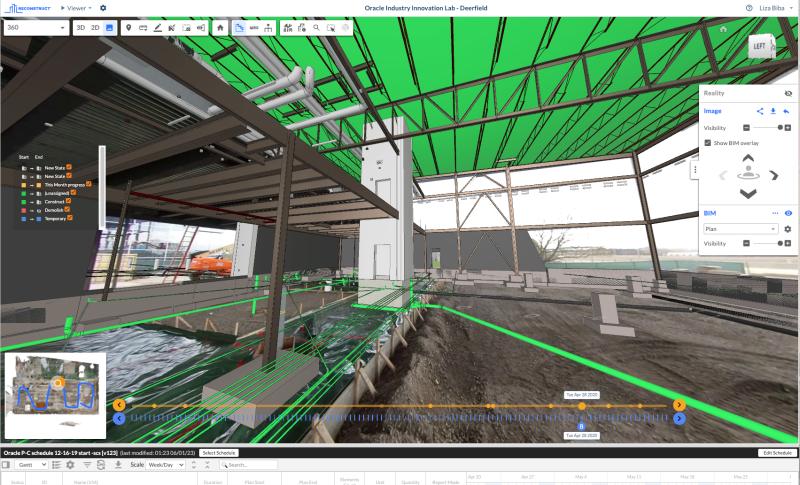
#realitymapping and #qualityassurance of foundations and slab-on-grade prior to concrete placement using @reconstructinc measurable street-view walkthrough, produced with a 360-degree video from @insta360.


Educators, bring the real world into your classroom with these #realitymapping resources: 🔸 Intro to ArcGIS Reality 🔸Teach reality mapping 🔸 ArcGIS Reality mesh gallery . Start here 👉 ow.ly/KgOc50V1gfk


Teaching #realitymapping just got more exciting! Bring 3D, photogrammetry, and drones into the classroom with these ArcGIS Reality teaching tools 🚁 ow.ly/wzOA50VAuLC

Ready to bring #drone data to the classroom? Check out these #realitymapping resources: ➡️ Introducing ArcGIS Reality ➡️ Teach reality mapping with ArcGIS Reality ➡️ ArcGIS Reality mesh gallery 🔗 ow.ly/YjIK50Wy11G


Thank you to all who joined @reconstructinc's @builtworlds session today. Amazing session with @mgolpar2, both online and onsite. We still have our booth up and running onsite! We encourage you to stop by and see a live #realitymapping demo before the day ends! #ConTech #AEC


NeRF: The Future of Reality Mapping? hubs.la/Q01WNHsw0 #RealityCapture #RealityMapping #photogrammetry #Construction #ProjectMonitoring #ArtificialIntelligence #NeRF @reconstructinc
Empower remote #qualitycontrol teams to rapidly identify quality concerns on a #construction site using #realitymapping technology.

Educators, bring the real world into your classroom with these #realitymapping resources: 🔸 Intro to ArcGIS Reality 🔸Teach reality mapping 🔸 ArcGIS Reality mesh gallery . Start here 🔗 ow.ly/w7Ky50UXSg6

Learning Resource Spotlight: Bring Your Imagery to Life with ArcGIS Reality Seminar 🛰️🌍 esri.social/a5nC50QxtY9 💡 Basic intro to #photogrammetry concepts 💡 Understand ArcGIS Reality capabilities 💡 Explore uses of #realitymapping data products across the #ArcGIS system

Jacqueline Nova 🌌 #novalikethebasemap Imagery Expert @esri presenting an out of this world demo utilizing ArcGIS Reality, Scene Viewer & 360 VR Experience #esrimuc #realitymapping #digitaltwins


Discover #ArcGISReality, @Esri’s suite of photogrammetry software that helps users create accurate digital renderings of objects and scenes at multiple scales and extents. esri.social/Ja6Q50OZHFJ #GIS #RealityMapping


¡Brutal las novedades que trajo #ArcGISPro y #RealityMapping para crear y analizar #GemelosDigitales del territorio! ¡Grandes Celia y Catalina! 👏🏻 #CEsri24 🌍


Reconstruct’s #realitymapping engine transforms 360 and smartphone videos into 2D reality plans and 3D point cloud models of your job site without uploading any floor plans. Click the link below to learn more. hubs.la/Q01Ng9wD0


It's not about the drone, it's about the data! 💡 In this article, we take a deep dive into the DJI P1 camera, it's benefits and how choosing the right drone camera can make your operations safe and deliver high quality results: buff.ly/3CZdy7O #drones #realitymapping


This #robot is built for #autonomous #realitymapping and can be programmed with waypoints to travel to. Set a schedule and let your Groundhog handle the rest!


Saremo presenti come Silver Sponsor alla Conferenza EsriI talia2024! Un'opportunità imperdibile per tutti gli appassionati ed esperti del settore di immergersi nelle nuove frontiere della #ScienceofWhere, tra #IntelligenzaArtificiale, #RealityMapping e #SostenibilitàAmbientale.


✅ Workshop Tecnologici 💡Parleremo di: #IntelligenzaArtificiale, #GeoAI, #RealityMapping, #ArcGIS System e #ArcGIS Data Pipelines; #ArcGIS App su Device; Integrazione GIS e BIM e di ArcGIS e Microsoft #RealtàVirtuale, #3DMapping 👉 bit.ly/3t3hfbu #Esri #GIS

Ready to bring #drone data to the classroom? Check out these #realitymapping resources: ➡️ Introducing ArcGIS Reality ➡️ Teach reality mapping with ArcGIS Reality ➡️ ArcGIS Reality mesh gallery 🔗 ow.ly/YjIK50Wy11G
Teaching #realitymapping just got more exciting! Bring 3D, photogrammetry, and drones into the classroom with these ArcGIS Reality teaching tools 🚁 ow.ly/wzOA50VAuLC
Educators, bring the real world into your classroom with these #realitymapping resources: 🔸 Intro to ArcGIS Reality 🔸Teach reality mapping 🔸 ArcGIS Reality mesh gallery . Start here 👉 ow.ly/KgOc50V1gfk
Educators, bring the real world into your classroom with these #realitymapping resources: 🔸 Intro to ArcGIS Reality 🔸Teach reality mapping 🔸 ArcGIS Reality mesh gallery . Start here 🔗 ow.ly/w7Ky50UXSg6
¡Brutal las novedades que trajo #ArcGISPro y #RealityMapping para crear y analizar #GemelosDigitales del territorio! ¡Grandes Celia y Catalina! 👏🏻 #CEsri24 🌍
How 360 capture helps airport stakeholders improve efficiencies throughout the #construction process. #digitaltwin #realitymapping Learn more: hubs.la/Q02zW-wl0
This #robot is built for #autonomous #realitymapping and can be programmed with waypoints to travel to. Set a schedule and let your Groundhog handle the rest!

✅ Workshop Tecnologici 💡Parleremo di: #IntelligenzaArtificiale, #GeoAI, #RealityMapping, #ArcGIS System e #ArcGIS Data Pipelines; #ArcGIS App su Device; Integrazione GIS e BIM e di ArcGIS e Microsoft #RealtàVirtuale, #3DMapping 👉 bit.ly/3t3hfbu #Esri #GIS
How 360 cameras make #realitymapping that much easier and affordable. Learn more: hubs.la/Q02tf4_W0
blog.reconstructinc.com
9 Reasons 360 Capture for Reality Mapping is Easier Than Ever
360 capture makes reality mapping easier than ever because 360 cameras are inexpensive, virtually anyone on site can use them, and so much more.
How to measure a job site without laser scanning. #digitaltwin #realitymapping Learn more: hubs.la/Q02rM0HV0
blog.reconstructinc.com
Measurability and Construction Reality Mapping
Reality mapping now allows construction stakeholders to measure digital twins generated from 360 capture, no laser scanning or BIM required.
Saremo presenti come Silver Sponsor alla Conferenza EsriI talia2024! Un'opportunità imperdibile per tutti gli appassionati ed esperti del settore di immergersi nelle nuove frontiere della #ScienceofWhere, tra #IntelligenzaArtificiale, #RealityMapping e #SostenibilitàAmbientale.
This #robot is built for #autonomous #realitymapping and can be programmed with waypoints to travel to. Set a schedule and let your Groundhog handle the rest!

Learning Resource Spotlight: Bring Your Imagery to Life with ArcGIS Reality Seminar 🛰️🌍 esri.social/a5nC50QxtY9 💡 Basic intro to #photogrammetry concepts 💡 Understand ArcGIS Reality capabilities 💡 Explore uses of #realitymapping data products across the #ArcGIS system
Jacqueline Nova 🌌 #novalikethebasemap Imagery Expert @esri presenting an out of this world demo utilizing ArcGIS Reality, Scene Viewer & 360 VR Experience #esrimuc #realitymapping #digitaltwins

NeRF: The Future of Reality Mapping? hubs.la/Q01WNHsw0 #RealityCapture #RealityMapping #photogrammetry #Construction #ProjectMonitoring #ArtificialIntelligence #NeRF @reconstructinc
#realitymapping and #qualityassurance of foundations and slab-on-grade prior to concrete placement using @reconstructinc measurable street-view walkthrough, produced with a 360-degree video from @insta360.
Learning Resource Spotlight: Bring Your Imagery to Life with ArcGIS Reality Seminar 🛰️🌍 esri.social/a5nC50QxtY9 💡 Basic intro to #photogrammetry concepts 💡 Understand ArcGIS Reality capabilities 💡 Explore uses of #realitymapping data products across the #ArcGIS system
Ready to bring #drone data to the classroom? Check out these #realitymapping resources: ➡️ Introducing ArcGIS Reality ➡️ Teach reality mapping with ArcGIS Reality ➡️ ArcGIS Reality mesh gallery 🔗 ow.ly/YjIK50Wy11G
Teaching #realitymapping just got more exciting! Bring 3D, photogrammetry, and drones into the classroom with these ArcGIS Reality teaching tools 🚁 ow.ly/wzOA50VAuLC
Discover #ArcGISReality, @Esri’s suite of photogrammetry software that helps users create accurate digital renderings of objects and scenes at multiple scales and extents. esri.social/Ja6Q50OZHFJ #GIS #RealityMapping
Educators, bring the real world into your classroom with these #realitymapping resources: 🔸 Intro to ArcGIS Reality 🔸Teach reality mapping 🔸 ArcGIS Reality mesh gallery . Start here 👉 ow.ly/KgOc50V1gfk
Thank you to all who joined @reconstructinc's @builtworlds session today. Amazing session with @mgolpar2, both online and onsite. We still have our booth up and running onsite! We encourage you to stop by and see a live #realitymapping demo before the day ends! #ConTech #AEC
Educators, bring the real world into your classroom with these #realitymapping resources: 🔸 Intro to ArcGIS Reality 🔸Teach reality mapping 🔸 ArcGIS Reality mesh gallery . Start here 🔗 ow.ly/w7Ky50UXSg6
Empower remote #qualitycontrol teams to rapidly identify quality concerns on a #construction site using #realitymapping technology.
Reconstruct’s #realitymapping engine transforms 360 and smartphone videos into 2D reality plans and 3D point cloud models of your job site without uploading any floor plans. Click the link below to learn more. hubs.la/Q01Ng9wD0
✅ Workshop Tecnologici 💡Parleremo di: #IntelligenzaArtificiale, #GeoAI, #RealityMapping, #ArcGIS System e #ArcGIS Data Pipelines; #ArcGIS App su Device; Integrazione GIS e BIM e di ArcGIS e Microsoft #RealtàVirtuale, #3DMapping 👉 bit.ly/3t3hfbu #Esri #GIS
Jacqueline Nova 🌌 #novalikethebasemap Imagery Expert @esri presenting an out of this world demo utilizing ArcGIS Reality, Scene Viewer & 360 VR Experience #esrimuc #realitymapping #digitaltwins
It's not about the drone, it's about the data! 💡 In this article, we take a deep dive into the DJI P1 camera, it's benefits and how choosing the right drone camera can make your operations safe and deliver high quality results: buff.ly/3CZdy7O #drones #realitymapping
¡Brutal las novedades que trajo #ArcGISPro y #RealityMapping para crear y analizar #GemelosDigitales del territorio! ¡Grandes Celia y Catalina! 👏🏻 #CEsri24 🌍
Saremo presenti come Silver Sponsor alla Conferenza EsriI talia2024! Un'opportunità imperdibile per tutti gli appassionati ed esperti del settore di immergersi nelle nuove frontiere della #ScienceofWhere, tra #IntelligenzaArtificiale, #RealityMapping e #SostenibilitàAmbientale.
This #robot is built for #autonomous #realitymapping and can be programmed with waypoints to travel to. Set a schedule and let your Groundhog handle the rest!
Something went wrong.
Something went wrong.
United States Trends
- 1. Steph 50.4K posts
- 2. Wemby 23.7K posts
- 3. Spurs 26.4K posts
- 4. Draymond 8,807 posts
- 5. Clemson 10.8K posts
- 6. Louisville 10.6K posts
- 7. #SmackDown 47.8K posts
- 8. Zack Ryder 14.6K posts
- 9. Aaron Fox 1,668 posts
- 10. #DubNation 1,770 posts
- 11. Dabo 1,926 posts
- 12. Harden 11.7K posts
- 13. Brohm 1,533 posts
- 14. Landry Shamet 5,442 posts
- 15. #OPLive 2,434 posts
- 16. Matt Cardona 2,686 posts
- 17. Marjorie Taylor Greene 39.4K posts
- 18. Miller Moss N/A
- 19. UCLA 7,962 posts
- 20. #CLAWMARK3D 37.3K posts