#remotesensingtutorial search results

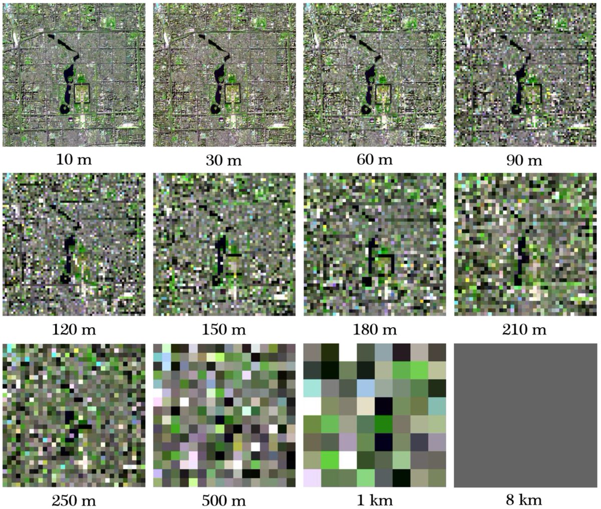
What is Spatial resolution in remote sensing? Remote Sensing tutorial Tutorial Link: youtu.be/5Y41s3GnYjM #SpatialResolution #RemoteSensing #RemoteSensingTutorial #Geospatial #EarthObservation #SatelliteImagery #DataAnalysis

Geometric Correction Envisat ASAR Data Using ESA SNAP youtu.be/W9uuGfQ_NDM via @YouTube #radartutorial #remotesensingtutorial #gistutorial #esasnap #envisat #asar
Automatic Masking of Sentinel 2 Imagery Using ESA SNAP youtu.be/G7-YfrLrfjA lewat @YouTube #remotesensingtutorial #esasnap #sentinel2
Extract Water Surface Features From Sentinel 1 Data Using ESA SNAP youtu.be/Y1sPPFTIBrE lewat @YouTube #remotesensingtutorial #esasnap #sentinel1
How to Extract Urban Built Up Area/Footprint from SAR Data (Part 1. Spec... youtu.be/bEcF92WGLsE via @YouTube #sartutorial #esasnaptutorial #remotesensingtutorial
Radarsat 1 Terrain Correction Using ESA SNAP youtu.be/zEfFlGeGo3g via @YouTube #remotesensing #sar #remotesensingtutorial #gis #gistutorial #esasnap
What is Spatial resolution in remote sensing? Remote Sensing tutorial Tutorial Link: youtu.be/5Y41s3GnYjM #SpatialResolution #RemoteSensing #RemoteSensingTutorial #Geospatial #EarthObservation #SatelliteImagery #DataAnalysis
Geometric Correction Envisat ASAR Data Using ESA SNAP youtu.be/W9uuGfQ_NDM via @YouTube #radartutorial #remotesensingtutorial #gistutorial #esasnap #envisat #asar
How to Extract Urban Built Up Area/Footprint from SAR Data (Part 1. Spec... youtu.be/bEcF92WGLsE via @YouTube #sartutorial #esasnaptutorial #remotesensingtutorial
Automatic Masking of Sentinel 2 Imagery Using ESA SNAP youtu.be/G7-YfrLrfjA lewat @YouTube #remotesensingtutorial #esasnap #sentinel2
Radarsat 1 Terrain Correction Using ESA SNAP youtu.be/zEfFlGeGo3g via @YouTube #remotesensing #sar #remotesensingtutorial #gis #gistutorial #esasnap
Extract Water Surface Features From Sentinel 1 Data Using ESA SNAP youtu.be/Y1sPPFTIBrE lewat @YouTube #remotesensingtutorial #esasnap #sentinel1
What is Spatial resolution in remote sensing? Remote Sensing tutorial Tutorial Link: youtu.be/5Y41s3GnYjM #SpatialResolution #RemoteSensing #RemoteSensingTutorial #Geospatial #EarthObservation #SatelliteImagery #DataAnalysis
Something went wrong.
Something went wrong.
United States Trends
- 1. Daboll 41.9K posts
- 2. Pond 237K posts
- 3. Schoen 19.5K posts
- 4. Schoen 19.5K posts
- 5. Giants 83.3K posts
- 6. Joe Burrow 5,290 posts
- 7. Veterans Day 21.6K posts
- 8. Kim Davis 12K posts
- 9. Go Birds 11.1K posts
- 10. Dart 27.6K posts
- 11. #ROBOGIVE N/A
- 12. Marines 58.1K posts
- 13. Johnny Carson N/A
- 14. #jimromeonx N/A
- 15. Jeffries 39.9K posts
- 16. Joe Dirt N/A
- 17. Semper Fi 11.3K posts
- 18. Kafka 9,878 posts
- 19. Hanoi Jane N/A
- 20. Edmund Fitzgerald 9,871 posts