#riskmapping search results

Epidemiologists don't just find solutions; they provide the evidence that guides those solutions. @mstevenson888 making sure the maps are visually compelling #Indonesia #AnimalHealth #RiskMapping #Training #CapacityBuilding #FAO


#riskmapping is an essential part of #NVZ and #soilandwater regs. Remember this needs updating with no spread zones when you have done any #subsoil #cultivations


First time @CHCymru Board meets for 2019 discussing key strategic issues facing sector & how CHC should respond @jvhuish @KathPalmerHafod @andrew_vye @AndrewBowden7 @KathPalmerHafod @pjk68 @Tregolwyn @SianTho56785492 @matt_brown85 @debbiegcoastal #riskmapping


Fascinated to co-deliver with Philippe Noirot and John Ludlow two workshops on #riskmapping CSR risks to 75 of the attendees @FERMARISK 2019 seminar #riskmanagement #modernslavery


Teaching alongside Professor @mstevenson888 at the Cross-Sectoral Risk Mapping Workshop for Priority Zoonotic Diseases in Indonesia! Looking forward to a fruitful collaboration and sharing our expertise. #ZoonoticDiseases #Indonesia #RiskMapping #Workshop #Teaching


Explore article to learn how to use ArcGIS Pro for fire risk mapping. #riskmapping #ArcGISPro bit.ly/3u1DDQv


If you’d like to participate in the next #AnnualConference of #AIMCOST now is your chance! Apply with your abstract before Oct 28th #RiskMapping #InsecticideResistance #Guidelines #Aedes #Invasive #Mosquitos aedescost.eu/lisbon2020 Let’s meet in February 2020 #Lisbon


Mapping has become increasingly important in assessing the spatial distribution of #animaldisease risk. The @EuFMD and @Cirad developed the online regional workshop #RiskMapping for improved FAST diseases surveillance & early detection. 👉 Read more: bit.ly/35DIpXx


A new #riskmapping publication from @EP_ThinkTank: After Covid, how do we get to a more resilient Europe? @FlorenceGaub @jpolchar @ricbdc @matburrows 1/2 europarl.europa.eu/RegData/etudes…


GDPR solution company @GDPRTech is ready for RIGA COMM 2019 exhibition. #GDPR #DataAnalyzing #RiskMapping #Trainings #SoftwareSolutions #gdprtech #dataprotection #personaldata #rc19exhibitor #rigacomm2019 #rigacomm


Presenting results from our study: Development of a Risk Scoring System to Support Maternal & Child Health Planning in Chad. #KML_MNHQoC #Riskmapping #MCH #HealthSystemPrioritisation #Chad #Tchad @acameh @LSTMnews @GlobalFund @TakedaPharma


iRAP latest metrics show work across 101 countries, European #riskmapping growth, 770 #schoolassessments in 38 countries, great #trainingactivity & an additional USD$11.3 billion in #saferroads #investment in the last 12 months. #workingtogether #UNgoals irap.org/2020/06/latest…


#ThrowbackMonday to our previous #OneHealth #RiskMapping training @FAOIndonesia training in Jakarta a few weeks ago... and we're back again already! This time with @simon_firestone to teach #SocialNetworkAnalysis to our enthusiastic Indonesian trainees.


Join us Tue 11 Oct to find out from @Tesco how we helped streamline its #riskmanagement processes through an integrated safety #riskmapping system; guest speakers Matt Doughty Group Risk Systems Mgr & Paul Bordoni Head of Group Safety at Tesco Register: ow.ly/ywIq50KY3nw

Our Indonesian #RiskMapping trainees off their computers for a change, getting to grips with #CausalDiagrams for #EmergingInfectiousDisease and #Zoonoses. Great #CapacityBuilding work togehtet with @mstevenson888 from @ApcahUnimelb @FVASunimelb


At an AAFA webinar, Kara Brennion of BSI Consulting explained the benefits of enhanced transparency for risk mapping are that it allows you to have early warning signs for disruption and to detect them before they escalate. just-style.com/news/risk-mapp… #riskmapping #supplychain

How many samples are needed to prepare for a robust #spatialmodel? Join the first 2022 #VECMAP webinar with MOOD partner @AviaGIS on Fri 25.2 at 12 PM CET to discuss the importance of this step! Info®istration: bit.ly/3BaThKE #riskmapping @GuyHendrickx3


Understand exposure to risk. Learn how to protect your business better. Discover new business development opportunities businessrisktv.com/risk-insight-b… #BusinessRiskTV #RiskMap #RiskMapping #RiskReports #RiskReview


Larisa Lee Cruz : cartographie des zones à risque de transmission du virus #Ebola en Guinée forestières par la méthode d'évaluation multi-critère spatialisée #MCDA #riskmapping @Cirad @AgroParisTech

At an AAFA webinar, Kara Brennion of BSI Consulting explained the benefits of enhanced transparency for risk mapping are that it allows you to have early warning signs for disruption and to detect them before they escalate. just-style.com/news/risk-mapp… #riskmapping #supplychain

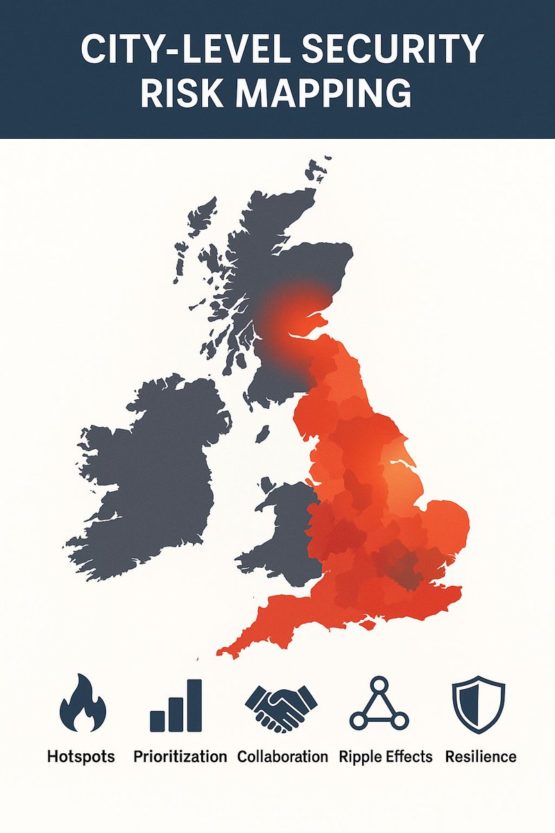
🗺️ Security isn’t the same everywhere. City-level risk mapping shows: 🔥 Hotspots 📊 Resource needs 🤝 Local collaboration 🌐 Ripple effects 🛡️ Resilience You can’t protect what you don’t see. Mapping turns blind spots into foresight. #riskmapping #dynamicreactions #securitytips

Climate risk mapping uses satellite data to identify hotspots for land degradation, guiding land-use planning and reforestation efforts .#RiskMapping #SahelResilience

Cyclones strike Wallis and Futuna on average once every five years; risk maps integrate historical cyclone tracks and population density to guide emergency planning .#CycloneRisk #RiskMapping

Community participatory mapping in Chitwan used GIS to identify 25 k flood-prone zones and designate safe-sites for shelters, enhancing local disaster plans. #RiskMapping #CommunityDRR

Insurers set zone‐based premiums and alert communities to mitigation measures before events. #AIDisasters #RiskMapping Parametric wildfire insurance covers pastoral lands.

Join AAFA & @BSI_UK to explores practical methods for strengthening your organization’s resilience! Discover how to safeguard your supply chain against today’s unpredictable challenges: bit.ly/3IYWVPT #RiskMapping

The National Emergency Management Office publishes a hazard map identifying high-risk zones for floods, storm surges, and landslides—guiding infrastructure planning and community drills. #RiskMapping #Preparedness
A risk-assessment GIS platform maps hazard zones—floodplains, erosion hotspots, and shelter locations—guiding planners and first responders in evacuation routing. #GIS #RiskMapping
Remote sensing technology maps landslide-prone areas overlapping mineral reserves, guiding safe mine placement and infrastructure planning. #RemoteSensing #RiskMapping

Community-based risk maps co-created with villages identify evacuation routes and safe havens for earthquakes and landslides, improving local preparedness. #CommunityDRR #RiskMapping
Geo‐spatial risk maps highlight communities at highest exposure to landslides and floods, guiding land‐use planning and relocation strategies. #RiskMapping #LandUse

Multi-hazard risk maps combine seismic, flood, and landslide data in GIS dashboards, guiding municipal zoning and emergency resource staging. #RiskMapping #GIS

A climate-vulnerability index scores £100 M of real-estate portfolios on site-specific sea-level and storm surge risk, guiding capital reallocation. #RiskMapping #RealEstate

AI-driven “fire risk index” overlays on municipal planning maps guide zoning regulations, preventing new developments in high-hazard buffer zones. #RiskMapping #UrbanPlanning
The government is working to improve disaster risk mapping by using technology to assess vulnerability and create detailed maps that guide disaster prevention efforts. #RiskMapping #TechInDisaster

📘 Machine Learning for Zoonotic Outbreaks in Southern India Predict anthrax & enterotoxaemia risks using ML, GIS & spatial stats. For vets, researchers, & data scientists. ISBN: 9789370205406 🔗 IIP Store: shorturl.at/uBsue #Zoonotic #Epidemiology #RiskMapping #IIPBooks


From slope stability to corridor planning, precise elevation data drives decisions.Mapex makes it possible with advanced DSM, DTM & DEM solutions. #DigitalElevation #3DModeling #RiskMapping #GeospatialTech #MapexAi #UrbanPlanning #LiDARSolutions #Mapex

Honduras is promoting the use of geospatial technology, including GIS (Geographic Information Systems), to map disaster risks, plan emergency responses, and monitor damage in real-time. #GeospatialTech #RiskMapping


Participatory #riskmapping workshop @RNLI future leaders programme in #Zanzibar. @nileswimmers @stevetraveller

@RNLI are working with partners in Tanzania on #watersafety education, survival skills and rescue training - opportunity for #collaboration? We also love community #riskmapping!

Mapping has become increasingly important in assessing the spatial distribution of #animaldisease risk. The @EuFMD and @Cirad developed the online regional workshop #RiskMapping for improved FAST diseases surveillance & early detection. 👉 Read more: bit.ly/35DIpXx
Epidemiologists don't just find solutions; they provide the evidence that guides those solutions. @mstevenson888 making sure the maps are visually compelling #Indonesia #AnimalHealth #RiskMapping #Training #CapacityBuilding #FAO
Fun morning with #GIscientist's of the future! #RiskMapping #Tectonics #GeoHazards #STEM #GIS @MCBGeology #WeMap @QueensUBelfast @esriuk


#riskmapping is an essential part of #NVZ and #soilandwater regs. Remember this needs updating with no spread zones when you have done any #subsoil #cultivations
Prioritise your risk actions with the help of a Risk Mapping Process positiveriskmanagement.com/Pages/Risk_Map… #RiskMapping

First time @CHCymru Board meets for 2019 discussing key strategic issues facing sector & how CHC should respond @jvhuish @KathPalmerHafod @andrew_vye @AndrewBowden7 @KathPalmerHafod @pjk68 @Tregolwyn @SianTho56785492 @matt_brown85 @debbiegcoastal #riskmapping
Teaching alongside Professor @mstevenson888 at the Cross-Sectoral Risk Mapping Workshop for Priority Zoonotic Diseases in Indonesia! Looking forward to a fruitful collaboration and sharing our expertise. #ZoonoticDiseases #Indonesia #RiskMapping #Workshop #Teaching
Explore article to learn how to use ArcGIS Pro for fire risk mapping. #riskmapping #ArcGISPro bit.ly/3u1DDQv
Presenting results from our study: Development of a Risk Scoring System to Support Maternal & Child Health Planning in Chad. #KML_MNHQoC #Riskmapping #MCH #HealthSystemPrioritisation #Chad #Tchad @acameh @LSTMnews @GlobalFund @TakedaPharma
Join us Tue 11 Oct to find out from @Tesco how we helped streamline its #riskmanagement processes through an integrated safety #riskmapping system; guest speakers Matt Doughty Group Risk Systems Mgr & Paul Bordoni Head of Group Safety at Tesco Register: ow.ly/ywIq50KY3nw

@NASA 's Dr Assaf Anyamba highlighted the critical #geotagged #pathogen reports that @ProMED_mail provides everyday for #riskmapping of #vectorborne #disease using #satellite imagery. #remotesensing #infectiousdiseases


Discussing #RiskMapping with experts from EU and southern Mediterranean countries. Let's work and progress together!


RT tommecrow: Participatory #riskmapping workshop RNLI future leaders programme in #Zanzibar. nileswimmers steve... ift.tt/YhTXtX
Fascinated to co-deliver with Philippe Noirot and John Ludlow two workshops on #riskmapping CSR risks to 75 of the attendees @FERMARISK 2019 seminar #riskmanagement #modernslavery
iRAP latest metrics show work across 101 countries, European #riskmapping growth, 770 #schoolassessments in 38 countries, great #trainingactivity & an additional USD$11.3 billion in #saferroads #investment in the last 12 months. #workingtogether #UNgoals irap.org/2020/06/latest…
If you’d like to participate in the next #AnnualConference of #AIMCOST now is your chance! Apply with your abstract before Oct 28th #RiskMapping #InsecticideResistance #Guidelines #Aedes #Invasive #Mosquitos aedescost.eu/lisbon2020 Let’s meet in February 2020 #Lisbon
Our Indonesian #RiskMapping trainees off their computers for a change, getting to grips with #CausalDiagrams for #EmergingInfectiousDisease and #Zoonoses. Great #CapacityBuilding work togehtet with @mstevenson888 from @ApcahUnimelb @FVASunimelb
GDPR solution company @GDPRTech is ready for RIGA COMM 2019 exhibition. #GDPR #DataAnalyzing #RiskMapping #Trainings #SoftwareSolutions #gdprtech #dataprotection #personaldata #rc19exhibitor #rigacomm2019 #rigacomm
Something went wrong.
Something went wrong.
United States Trends
- 1. Chiefs 45K posts
- 2. Colts 19.5K posts
- 3. Steelers 33.3K posts
- 4. Caleb 29.5K posts
- 5. Jameis 8,199 posts
- 6. Drake Maye 6,428 posts
- 7. Lamar 17.2K posts
- 8. Flacco 3,440 posts
- 9. #HereWeGo 3,949 posts
- 10. Marcus Jones 1,620 posts
- 11. #Bears 4,902 posts
- 12. #OnePride 1,976 posts
- 13. TJ Watt 3,248 posts
- 14. Arsenal 401K posts
- 15. Gibbs 4,459 posts
- 16. #GoPackGo 2,831 posts
- 17. #Skol 1,710 posts
- 18. Mason Rudolph 4,043 posts
- 19. Tony Romo 1,510 posts
- 20. Money Mac N/A