#utwx risultati di ricerca

Beautiful drone views from Utah’s Mirror Lake Highway, but the Southwest snowpack has been STRUGGLING, with above-average temperatures driving an unusually early melt. 🏔️#UTwx
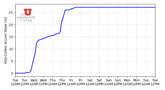
It was Mogul Monday at Alta Ski Resort in the Wasatch yesterday, and after an abysmal snow season, relief is finally on the way as a snowy pattern returns to Utah’s high peaks. #UTwx
No need to worry, our drought-stricken friends, more snow is on the way! Winter alerts are expanding across the Four Corners, where feet of snow are in the forecast. #UTwx #COwx
The Western U.S. has finally begun to receive rainfall! After a dry and warm winter, states like Utah have kicked off meteorological spring with rain & snow. This moisture will eventually fuel severe storms in the South Plains. #UTwx
Snowpack in Utah’s Wasatch Mountains is becoming increasingly concerning. While some snow is in the forecast, it’s unlikely to make a meaningful dent in the state’s ongoing drought. #UTwx
A dazzling display at Snowbasin in northern Utah. Fortunately, an active pattern continues across the very dry Beehive State. #UTwx
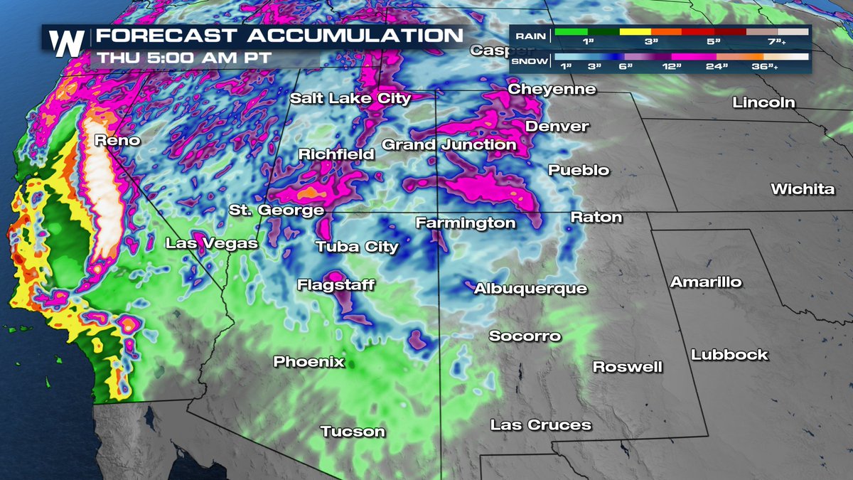
After a dominate ridge baked the Southwest in record setting heat, moisture is back in the forecast for the 4 corners! Rain and high-elevation snow will help chip away at the record-low snowpack while also bringing some relief from the heat! #UTwx #COwx #AZwx #NMwx
Stunning, as always! 🏔️But the already dim snowpack in the Rockies, Wasatch, Sierra Nevada, etc are in danger from this major heatwave that is impacting a massive part of the west this week. Temps at some of these mountain ski resorts are forecast to be in the 70s! 🥵 #UTwx

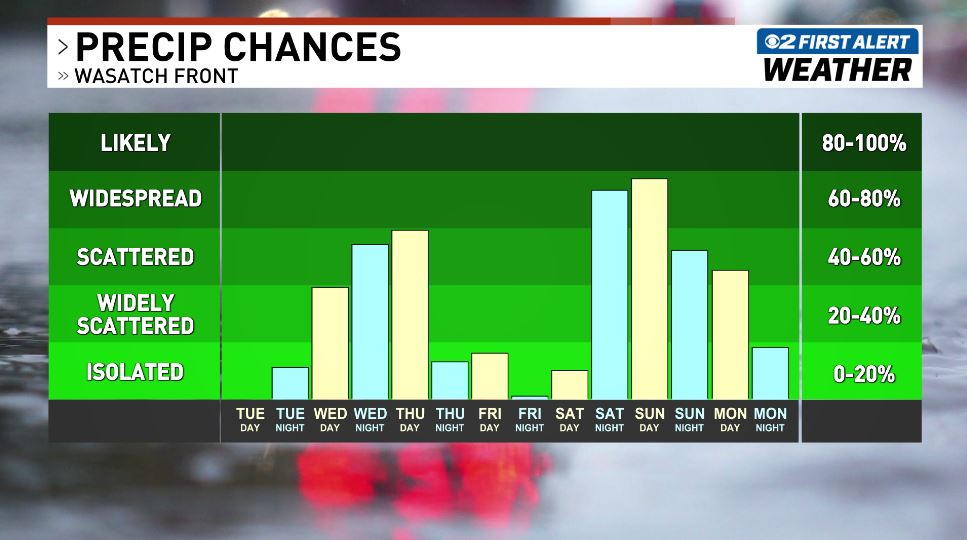
We have several rain chances over the next several days. I'll break down the timing and totals coming up on 2News at 5, 6 & 10 PM. See ya soon! #utwx
INCREDIBLE! Check out this massive shelf cloud towering over northern Utah earlier this morning! 🌩️ The storms around the greater Weber County area were never "severe warned" but they produced a ton of lightning & gusty winds! #UTwx
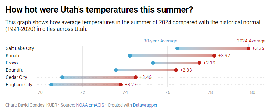
Utah's summer this year was more than 3 degrees warmer than the past 30 year average. That causes all kinds of impacts on Utah, like enhancing wildfire conditions, drought, heat waves, etc. We need to reduce our emissions #utpol #utwx kuer.org/science-enviro…

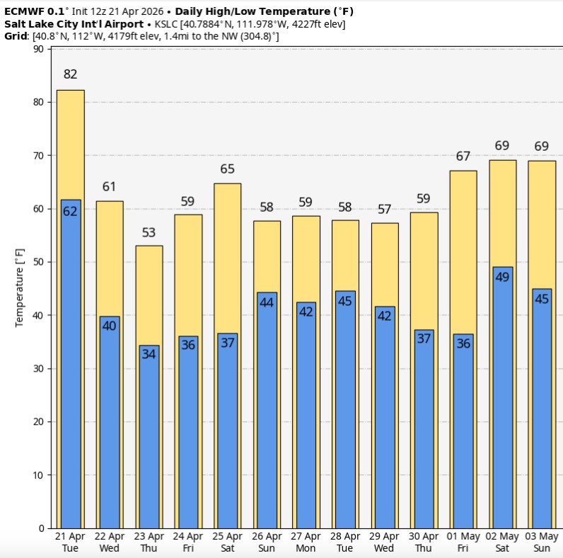
Enjoy it while it lasts—today looks like our final day in the 80s for a while. A cooler pattern settles in after this, with highs mostly in the 50s and 60s along the Wasatch Front over the next couple of weeks. #utwx
Winter Wonderland ❄️: Utah State University was blanketed in snow today as rain and snow keep the southwest active. Utah's winter alerts continue through Friday morning. #UTwx

Snow from the deformation band on Saturday is still showing up nicely in yesterday's satellite photo. (Also, models did quite well in the placement of the band all things considered!) #utwx

Tonight, we play a game called "Where will the front stall?" It is a very fun game whose outcome will determine how deep the snow is tomorrow.


🍁🍂A stunning mix of seasons in Big Cottonwood Canyon today — fall colors glowing below with fresh snow falling on the mountain tops! Great video, @Grallon !! #utwx @fox13
A large portion of the west may remember this winter for being one of the driest & warmest of their lifetime. Regardless, a nice push of moisture is racing through the Four Corners & Great Basin today - bringing snow to the mountains & some rain to the lower elevations! #UTwx
#GreatSaltLake fuel forecast In the action 🌧️❄️🌧️❄️ 9" on Alta so far. #utwx #cowx #Idwx #wywx #SKI #Skiutah #skiIdaho #skicolorado #skiwyoming #nvwx #mtwx #CAwx #azwx youtube.com/watch?v=2jyIn_…

youtube.com
YouTube
Chris Tomer
New event. Freeze Watch from 4/28/2026 12:00 AM to 9:00 AM MDT for Sevier County, UT, Juab County, UT, Emery ... inws.ncep.noaa.gov/a/a.php?i=1269… @weathercaster #utwx

At 2:00 PM MDT, 17 NW Moab [Grand Co, UT] ASOS reports Tstm Wnd Gst of M53 MPH #utwx mesonet.agron.iastate.edu/lsr/?by=wfo&wf…
![WCO_EUTWx's tweet image. At 2:00 PM MDT, 17 NW Moab [Grand Co, UT] ASOS reports Tstm Wnd Gst of M53 MPH #utwx mesonet.agron.iastate.edu/lsr/?by=wfo&wf…](https://pbs.twimg.com/media/HG23DNTWgAAeFx6.jpg)
At 2:00 PM MDT, 17 NW Moab [Grand Co, UT] ASOS reports Tstm Wnd Gst of M53 MPH #utwx mesonet.agron.iastate.edu/lsr/?by=wfo&wf…
![MidwestWeather3's tweet image. At 2:00 PM MDT, 17 NW Moab [Grand Co, UT] ASOS reports Tstm Wnd Gst of M53 MPH #utwx mesonet.agron.iastate.edu/lsr/?by=wfo&wf…](https://pbs.twimg.com/media/HG23DNjW0AAdF5y.jpg)

At 2:00 PM MDT, 17 NW Moab [Grand Co, UT] ASOS reports Tstm Wnd Gst of M53 MPH #utwx mesonet.agron.iastate.edu/lsr/?by=wfo&wf…
![iembot_gjt's tweet image. At 2:00 PM MDT, 17 NW Moab [Grand Co, UT] ASOS reports Tstm Wnd Gst of M53 MPH #utwx mesonet.agron.iastate.edu/lsr/?by=wfo&wf…](https://pbs.twimg.com/media/HG23DN7WoAACT58.jpg)
At 1:53 PM MDT, 17 NW Moab [Grand Co, UT] ASOS reports Tstm Wnd Gst of M52 MPH #utwx mesonet.agron.iastate.edu/lsr/?by=wfo&wf…
![iembot_gjt's tweet image. At 1:53 PM MDT, 17 NW Moab [Grand Co, UT] ASOS reports Tstm Wnd Gst of M52 MPH #utwx mesonet.agron.iastate.edu/lsr/?by=wfo&wf…](https://pbs.twimg.com/media/HG22WxqWkAAyA0a.jpg)
At 1:53 PM MDT, 17 NW Moab [Grand Co, UT] ASOS reports Tstm Wnd Gst of M52 MPH #utwx mesonet.agron.iastate.edu/lsr/?by=wfo&wf…
![MidwestWeather3's tweet image. At 1:53 PM MDT, 17 NW Moab [Grand Co, UT] ASOS reports Tstm Wnd Gst of M52 MPH #utwx mesonet.agron.iastate.edu/lsr/?by=wfo&wf…](https://pbs.twimg.com/media/HG22WwKXAAA3O54.jpg)
At 1:53 PM MDT, 17 NW Moab [Grand Co, UT] ASOS reports Tstm Wnd Gst of M52 MPH #utwx mesonet.agron.iastate.edu/lsr/?by=wfo&wf…
![WCO_EUTWx's tweet image. At 1:53 PM MDT, 17 NW Moab [Grand Co, UT] ASOS reports Tstm Wnd Gst of M52 MPH #utwx mesonet.agron.iastate.edu/lsr/?by=wfo&wf…](https://pbs.twimg.com/media/HG22WvlWoAAXJrY.jpg)

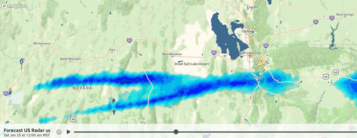
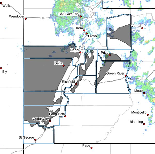
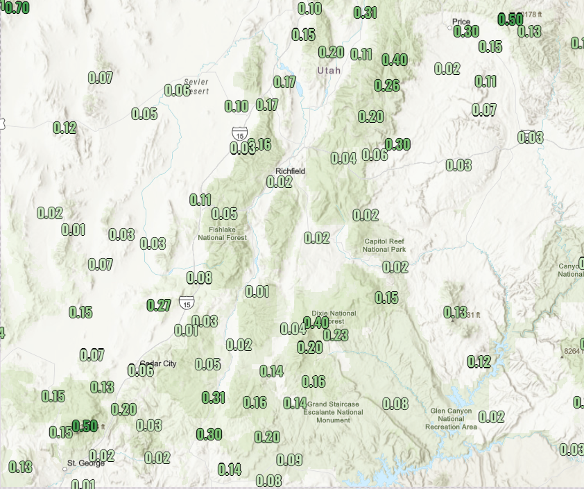
A wide range of rain totals so far today. Southerly flow has kept Tooele and Salt Lake counties shadowed (<0.1" of rain), whereas areas along the northern Wasatch Front and Utah county are wetter (up to 1"). Filling in now across Salt Lake as winds switch to the northwest. #utwx


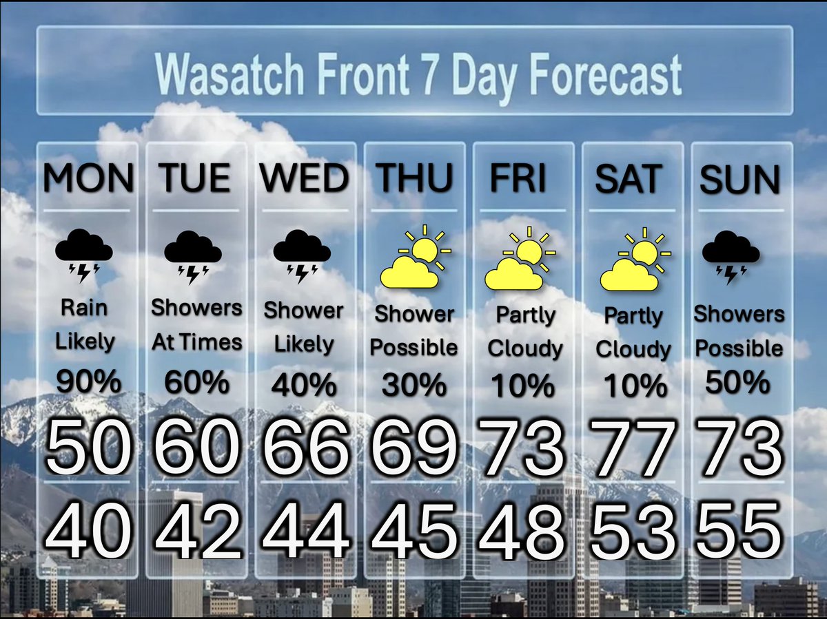
More Rain, a Break, Then More Showers A slow moving upper low pressure system is moving over the Wasatch Front Today and Tomorrow, with lingering showers on Wednesday. Look for a break back to partly cloudy skies, with showers returning on Sunday. @DanPopeWeather #utwx
At 4:56 AM MDT, 16 NW Moab [Grand Co, UT] ASOS reports Non-Tstm Wnd Gst of M47 MPH. ASOS station KCNY 16 NW Moab. #utwx mesonet.agron.iastate.edu/lsr/?by=wfo&wf…
![WCO_EUTWx's tweet image. At 4:56 AM MDT, 16 NW Moab [Grand Co, UT] ASOS reports Non-Tstm Wnd Gst of M47 MPH. ASOS station KCNY 16 NW Moab. #utwx mesonet.agron.iastate.edu/lsr/?by=wfo&amp;wf…](https://pbs.twimg.com/media/HG1CKFIW4AEHG-Y.jpg)
At 4:56 AM MDT, 16 NW Moab [Grand Co, UT] ASOS reports Non-Tstm Wnd Gst of M47 MPH. ASOS station KCNY 16 NW Moab. #utwx mesonet.agron.iastate.edu/lsr/?by=wfo&wf…
![iembot_gjt's tweet image. At 4:56 AM MDT, 16 NW Moab [Grand Co, UT] ASOS reports Non-Tstm Wnd Gst of M47 MPH. ASOS station KCNY 16 NW Moab. #utwx mesonet.agron.iastate.edu/lsr/?by=wfo&amp;wf…](https://pbs.twimg.com/media/HG1CKElW0AE6cj1.jpg)
An unsettled weather pattern has arrived bringing a mix of rain, snow, and storms to the region today. Hazardous travel is possible over mountain passes. #COwx #UTwx

Unless you live above 7500 ft or so, you probably wont encounter ❄️ flakes unless you have high altitude travel plans. Wet 🌧️ weather is otherwise overspreading much of the area though, and an unsettled pattern will persist into the upcoming week. #utwx #wywx

National High/Low temps for Saturday April 25, 2026: 104 at Rio Grande Village, TX; -16 at Peter Sinks, UT #txwx #utwx go.usa.gov/cu5tP
At 5:14 PM MDT, 1 E Vernal [Uintah Co, UT] ASOS reports Non-Tstm Wnd Gst of M46 MPH. ASOS station KVEL Vernal Rgnl Airport. #utwx mesonet.agron.iastate.edu/lsr/?by=wfo&wf…
![WCO_EUTWx's tweet image. At 5:14 PM MDT, 1 E Vernal [Uintah Co, UT] ASOS reports Non-Tstm Wnd Gst of M46 MPH. ASOS station KVEL Vernal Rgnl Airport. #utwx mesonet.agron.iastate.edu/lsr/?by=wfo&amp;wf…](https://pbs.twimg.com/media/HGypD2pWsAAGCr8.jpg)
At 5:14 PM MDT, 1 E Vernal [Uintah Co, UT] ASOS reports Non-Tstm Wnd Gst of M46 MPH. ASOS station KVEL Vernal Rgnl Airport. #utwx mesonet.agron.iastate.edu/lsr/?by=wfo&wf…
![iembot_gjt's tweet image. At 5:14 PM MDT, 1 E Vernal [Uintah Co, UT] ASOS reports Non-Tstm Wnd Gst of M46 MPH. ASOS station KVEL Vernal Rgnl Airport. #utwx mesonet.agron.iastate.edu/lsr/?by=wfo&amp;wf…](https://pbs.twimg.com/media/HGypD2BXsAAxLud.jpg)

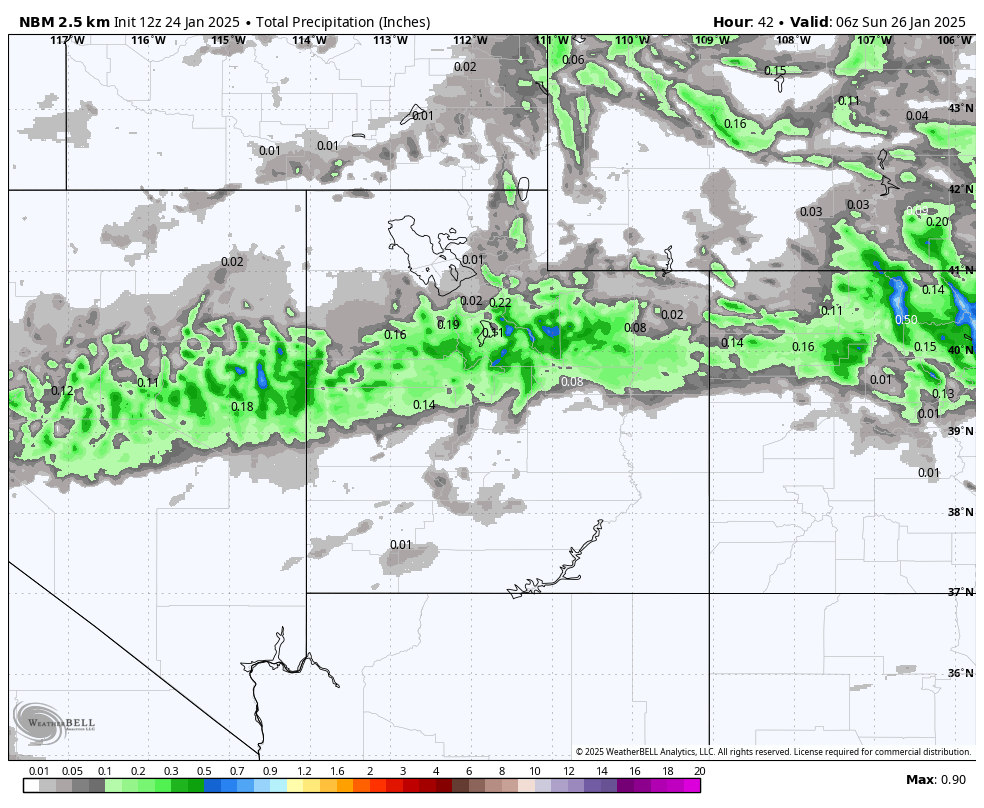
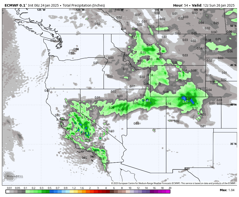
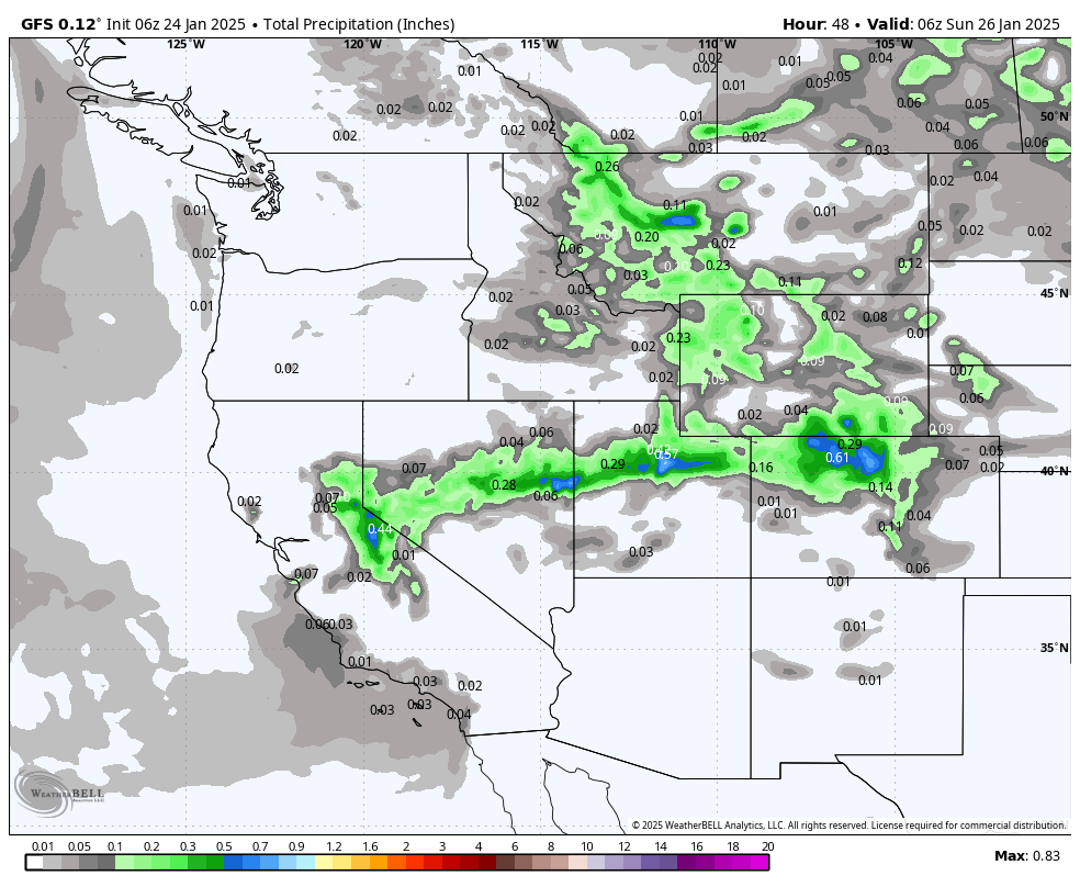
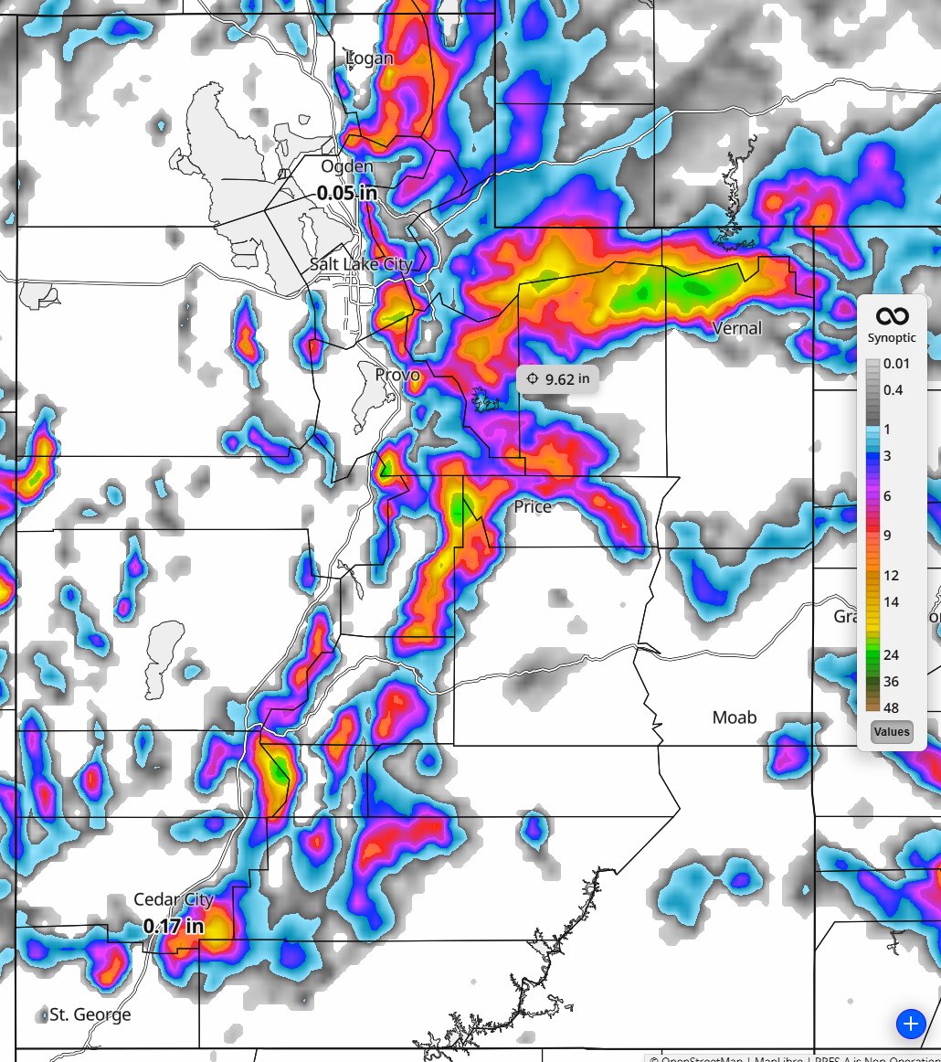
Back to winter for the mountains of Utah! Image is the 18Z RRFS model forecasted snowfall through 6pm Wed. The RRFS is an experimental next-generation high-resolution weather forecast model. Data provided by @SynopticWX #utwx
Our first round of valley rain and mountain snow moves in tonight with the heaviest precipitation Sunday morning across northern Utah. The second round will arrive on Monday. Here is how the HRRR model shows the first round playing out. #utwx #wywx
#GreatSaltLake fuel forecast Tomorrow M/H❄️with more to follow. Precipitation 92% of median GSL basin. #utwx #cowx #Idwx #wywx #SKI #Skiutah #skiIdaho #skicolorado #skiwyoming #nvwx #mtwx #CAwx #azwx youtube.com/watch?v=SIuEfC…

youtube.com
YouTube
Chris Tomer


The aliens are landing!! Man, I love it when standing lenticular clouds hover over beautiful scenery! Taken over Capitol Reef NP, Utah 2 days ago along the scenic drive during our vacation. Just doesn't get much prettier than this! #utwx


Southern #Utah is getting lots of #snow. By Wednesday it’s showing the Bryce Canyon area will get over 20 inches of new snow. #utwx

You can see two distinct bumps on this forecast plot for Alta Ski Area. First bump is Tonight into Wednesday morning, second bump is Thursday day into Friday morning. Could see totals up there around 24" by the end of this little one-two punch cycle. I like it. #utwx

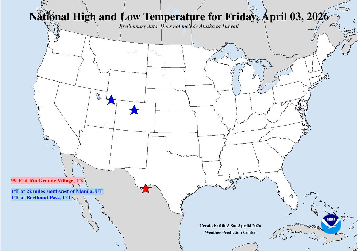
National High/Low temps for Friday April 03, 2026: 99 at Rio Grande Village, TX; 1 at 22 miles southwest of Manila, UT, Berthoud Pass, CO #txwx #utwx #cowx go.usa.gov/cu5tP
Storm has split. Northern Utah not looking at much at all, southern Utah gets the goods over the next 24 hours! #utwx
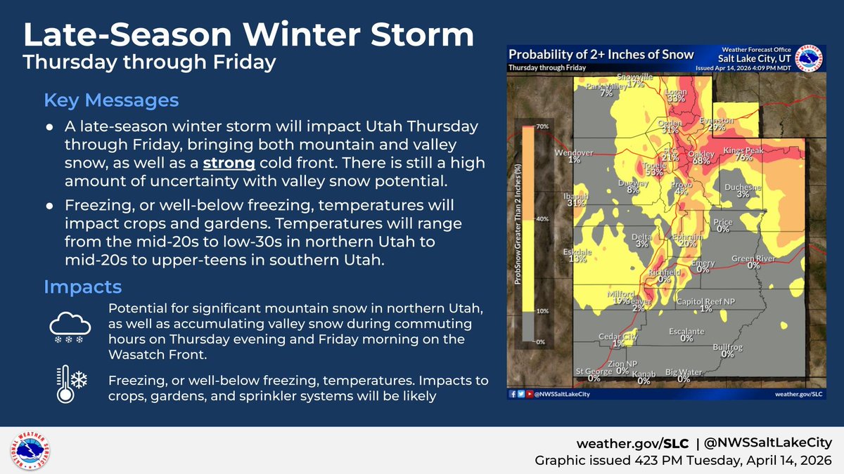
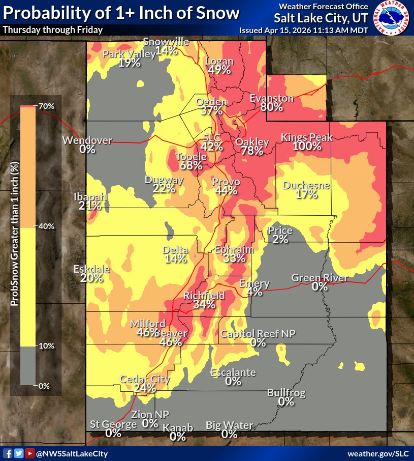
A late-season winter storm will move through the area from Thursday through Friday, bringing a variety of impacts ranging from mountain/ valley snowfall to freezing or below-freezing temperatures. Keep an eye on the forecast at weather.gov/slc #utwx #wywx
A cold front tomorrow will bring the coldest overnight lows in a month or more, along with wind and and a brief burst of snow to valley floors. Snow forecast has trended downward as the front is moving faster, though there is still a lake effect snow threat Thurs night #utwx
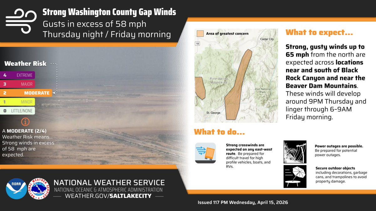
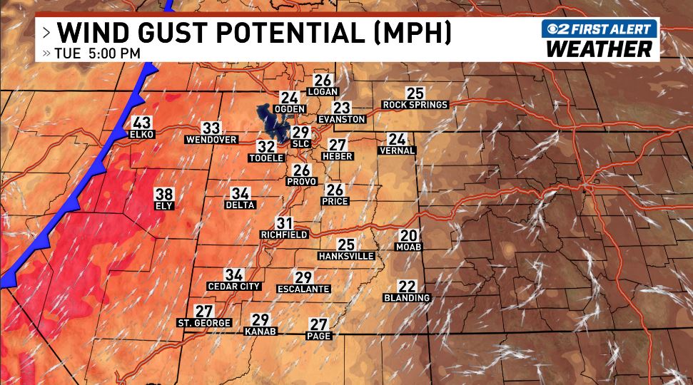
Strong winds are expected across Utah on Tuesday and Wednesday. A cold front will move through the state Wednesday morning, bringing a sharp temperature drop of 20-25 degrees. #utwx


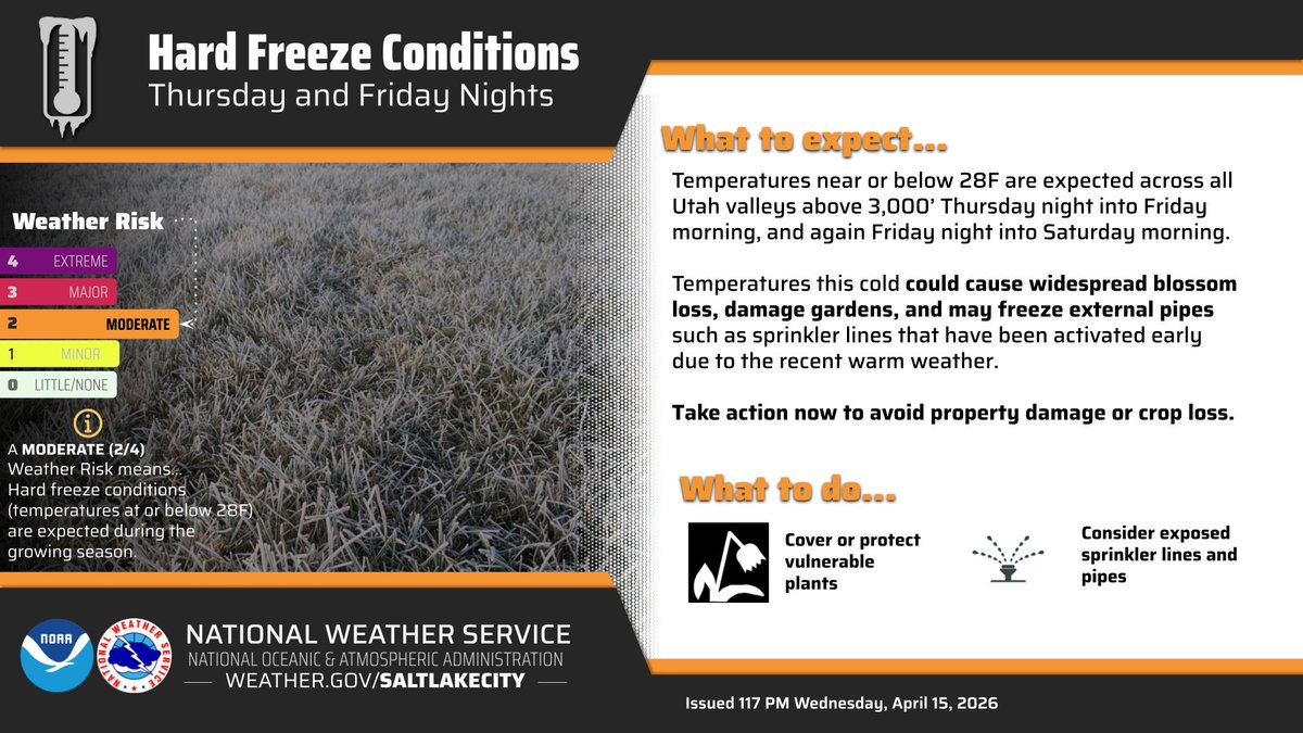
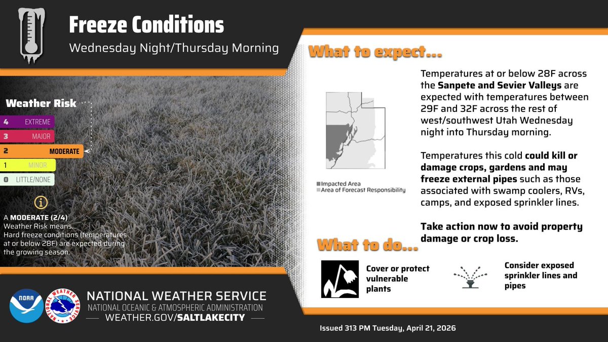
A cold airmass will move into the area on Wednesday evening. Skies will gradually clear overnight with temperatures at or below freezing for portions of western and southwestern Utah. The coldest temperatures (at or below 28F) will be across the Sanpete and Sevier Valleys. #utwx
Utah's summer this year was more than 3 degrees warmer than the past 30 year average. That causes all kinds of impacts on Utah, like enhancing wildfire conditions, drought, heat waves, etc. We need to reduce our emissions #utpol #utwx kuer.org/science-enviro…
🔥💨 Wildfire smoke has cleared out nicely for a beautiful but warm Saturday in the Front Range! However, thicker but lofted smoke may briefly make a return Sunday morning compliments of the #LittleTwistFire in SW Utah which was a prescribed burn gone wrong! #COWx #UTwx


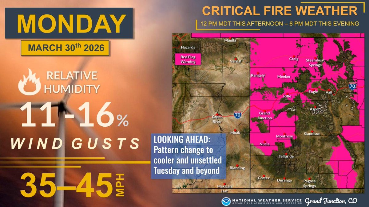
Hot, dry and windy conditions will lead to one more day of critical fire weather conditions before the pattern shifts to a cooler and unsettled one Tuesday and beyond. For today, Red Flag Warnings are in effect from 12-8 pm for lower elevations of NW and W-Central CO. #COwx #UTwx
RAIN CHANCES INCREASING: Valley rain and mountain snow looking more possible sometime in the window of April 11-14. Confidence isn't necessarily running high because these are cut-off low pressure systems without a ton of direction. I'll be updating. #utwx

Forecast certainty later this weekend is lower than usual with a less predictable spring storm track in place, but there is potential for significant valley rain (half inch to an inch) for central/northern valleys with 6-12" snow above 7,000 feet. Stay tuned. #UTwx

A strong cold front will move through northern Utah on Thursday, bringing significant snow to the mountains and the potential for valley accumulations as well. Mountain showers will continue into Friday morning before diminishing. #utwx #wywx


Something went wrong.
Something went wrong.
United States Trends
- 1. #euphoria N/A
- 2. #bucciovertimechallenge N/A
- 3. Pied Piper N/A
- 4. Ayton N/A
- 5. Nate N/A
- 6. Flagrant 2 N/A
- 7. Embiid N/A
- 8. 60 Minutes N/A
- 9. Maddy N/A
- 10. #SupernovaGenesis N/A
- 11. Lakers in 5 N/A
- 12. Game 5 N/A
- 13. Jules N/A
- 14. Joplin N/A
- 15. #RHOA N/A
- 16. Norah O'Donnell N/A
- 17. James Williams N/A
- 18. Sixers N/A
- 19. Sam Levinson N/A
- 20. #BaddiesUSAReunion N/A