#bearfire wyniki wyszukiwania
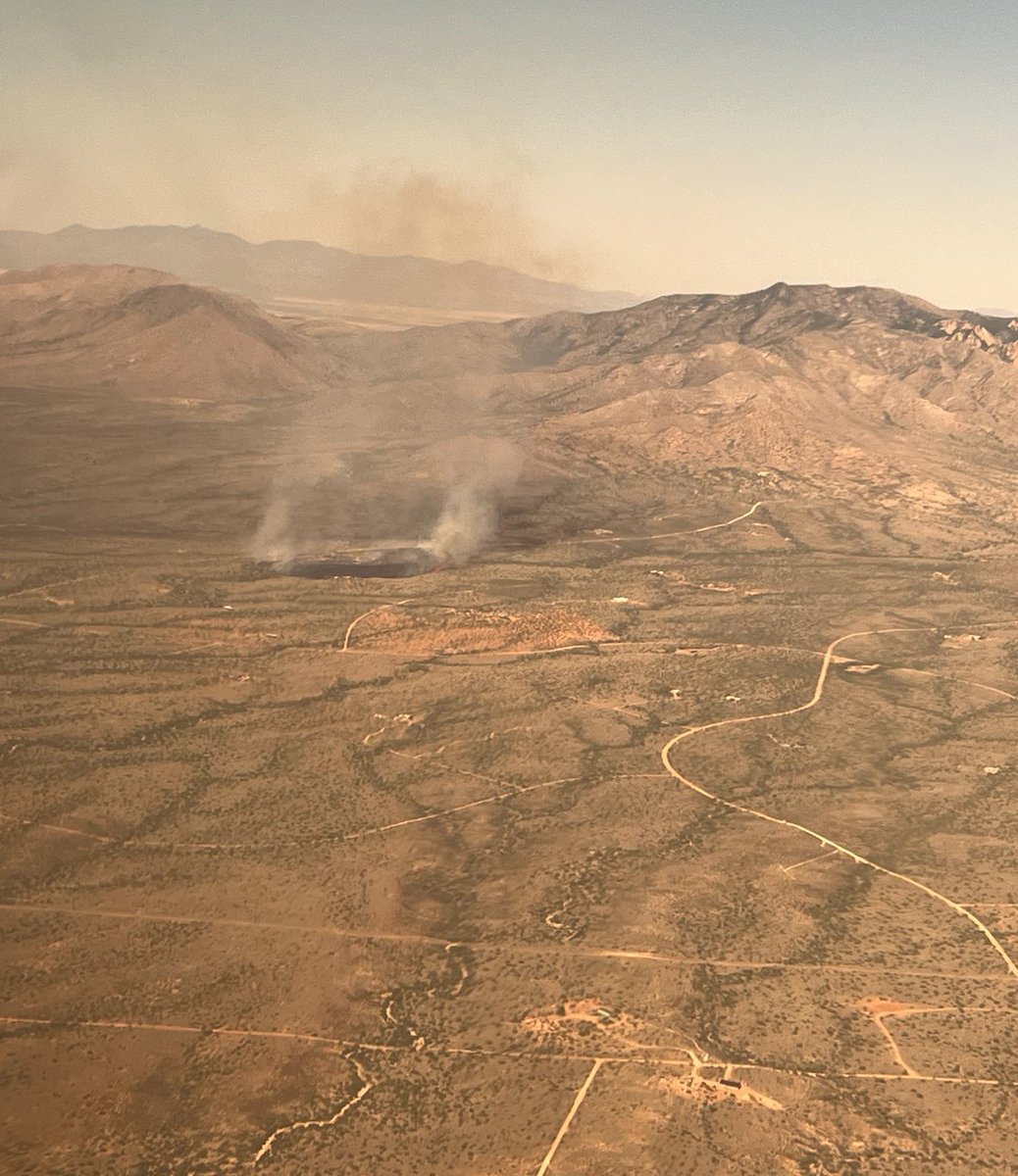
The Bear Fire: I think you’re gunna need some more crews. This fire is burning 8 miles south of Cibecue, Arizona. Resources are responding including 1 VLAT, 3 LATS, a Lead Plane, and 1 Hotshot Crew. Thanks to the subscriber who shared this 📷. 🙏 #azfire #bearfire #azwx

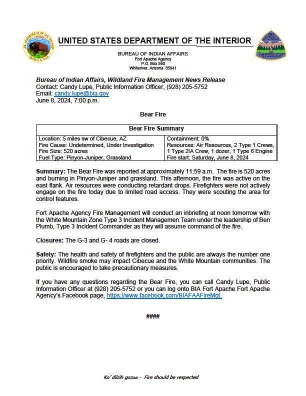
Arizona: The Bear Fire is now estimated over 500 acres. Entiat and Fort Apache Hotshots have been ordered along with aviation resources. Type 3 Team ordered. #wildfire #bearfire #azfire #azwx


The #BearFire in Sierra County is currently 30-40 acres with a high rate of spread. Evacuation "Go Now" order has been issued for Zone SIE-E031.

Arizona: The Bear Fire grew 30 acres yesterday after a slop over the retardant line. #bearfire #wildfire #azfire 3 new starts have been identified within 1 miles of this Fire’s main edge, interestingly. These starts are now the Black Fire and will also be managed by the Team on
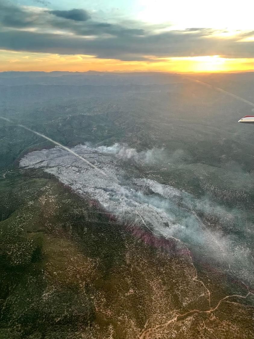
The Bear Fire this afternoon taken from Susanville, California. It’s not done yet… The fire is now over 1,400+ acres and is burning in the Tahoe National Forest. Thanks to the subscriber who sent this in 🙏. #wildfire #bearfire #cafire #cawx

Some crazy fire activity off the Bear Fire in the Tahoe National Forest. #cafire #cawx #bearfire #wildfire This fire whirl pushed the head of the fire 100 years in 25 seconds. An incredible amount of work was put in by folks on the ground and air, leading to this fire being 83%


All evacuation and pre-evacuation orders have been lifted for the #BearFire. Golden Gate Fire and multiple fire agencies did a great job creating a line around the fire. They continue to knock the fire down, do not expect it to grow, and will monitor overnight & into tomorrow.


The Bear Fire: Tankers put a hurtin on this thing before the sun went down. Crews should be hitting the line today. This fire is burning on Fort Apache ground in Arizona. Thanks to the subscriber who shared this 📷. #azfire #azwx #bearfire #wildfire
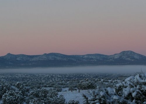
NEW - #BearFire,TahoeNationalForest #CAFire #CATNF Bear Fire, Tahoe National Forest: The Bear Fire was reported at 2 p.m. on September 2, 2024 off Bear Valley Rd. on the Tahoe National Forest, south of the community of Sierra Brooks in Sierra County.


#BearFire #AZFire #AZFTA bit.ly/3Vwry1Y Bear Fire: Updated Publication Added: Bear Fire

#BearFire #AZFire #AZFTA bit.ly/3zciHKZ Bear Fire: Updated Publication Added: Bear Fire

Bear Fire Update for Sep. 19, 2024 #BearFire

#BearFire 3,323 Acres 100% Contained Crews will continue to monitor and complete suppression repair activities. Thank you to all firefighters and support personnel—local, state and federal—that came from near and far to protect our natural resources and communities.
#BearFire E Bear Mountain Blvd, Deertrail Dr, Kern County. 12:27PM The size of the fire is 0.74 acres. 11:56AM Forward progress of the fire has been stopped. 11:50AM Resources are at scene of a quarter acre vegetation fire burning in grass per arriving unit.


The fire is now 2-3 acres making a good push uphill and actively torching trees. IC is requesting 1 additional hand crew and 1 additional type 3 engine. #BearFire

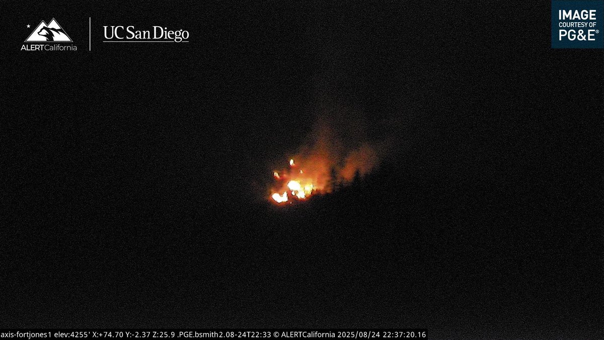
New start in Siskiyou County east of Hwy 3. This is the #BearFire and is 1 acre with a high rate of spread and active torching. The fire is accessible only by hiking in, moderate growth potential per IC.

#BearFire The Fire is 2-3 acres, moving uphill, with Tree Torching ongoing, no Structures Threatened.

New start in Siskiyou County east of Hwy 3. This is the #BearFire and is 1 acre with a high rate of spread and active torching. The fire is accessible only by hiking in, moderate growth potential per IC.
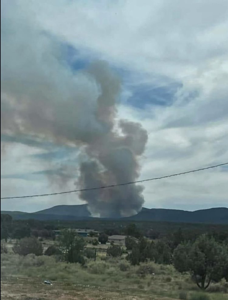
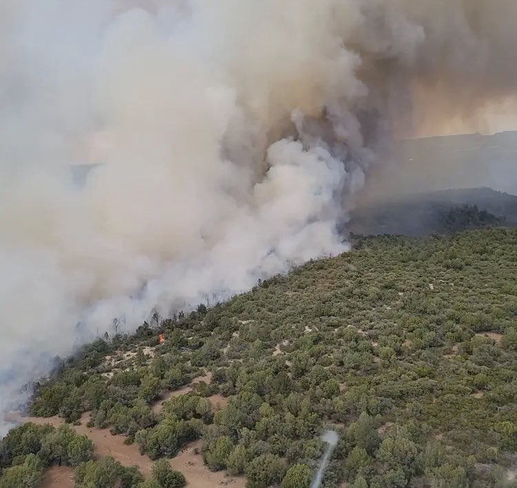
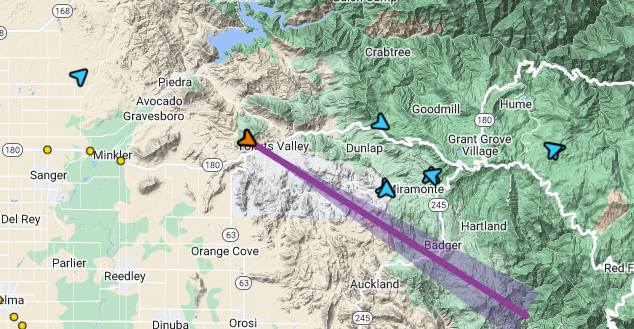
New #wildfire start #BearFire 07/24/25 0749 Gila National Forest Bear Canyon Coordinates: 33.417350, -108.67458 #NMFire 🔥🔥🔥


#BearFire Bena Rd ~3.5 miles north of Caliente Bodfish Rd, N/W of Caliente Kern County. 3:38AM Forward progress has been stopped per Incident Command - continuing 1 water tender & canceling the remainder of the response.
#BearFire Bena Rd ~3.5 miles north of Caliente Bodfish Rd, N/W of Caliente Kern County. 3:23AM The fire is 2 acres w/ slow rate of spread in grass & is burning in the flats.
#BearFire Bena Rd ~3.5 miles north of Caliente Bodfish Rd, N/W of Caliente Kern County. 3:10AM The fire is also visible on the Breckenridge Peak 1 camera linked above. Note: The location has been updated based on camera triangulations & radio traffic.
#BearFire Bena Rd ~3.5 miles north of Caliente Bodfish Rd, N/W of Caliente Kern County. 3:00AM Resources responding to a reported vegetation fire w/ smoke & glow visible on the Bealville 1 camera.
#BearFire East of Camp Nelson, Sequoia NF, 1 acre. Limited info available.
#BearFire Table Mountain Road and Bench Drive, Jamestown, Tuolumne County. 2:56PM The fire has been mapped with a final acreage of 1.15 acres.
#BearFire Table Mountain Road and Bench Drive, Jamestown, Tuolumne County. 2:00PM The hose lay is tied, and the fire is contained per incident command. Mop up 2 to 3 hours. 1:57PM Crews are making good progress with the hose lay, about 50% contained.
#BearFire Table Mountain Road and Bench Drive, Jamestown, Tuolumne County. 1:41PM The fire is approximately 3 acres, burning at a slow to moderate rate of spread in grass per incident command. A helicopter, two hand crews, and a water tender have been requested.
#BearFire Table Mountain Road and Bench Drive, Jamestown, Tuolumne County. 1:33PM Firefighters are on scene of a vegetation fire in the area reported to be approximately 2 acres burning at a moderate rate of spread in the grass with no immediate structure threat.

Members of DOGE, who do not have security clearance, gained access to the FEMA network with private info on Americans who received disaster relief grants. #CampFire #BearFire #NorthComplexFire #DixieFire #ParkFire #CarrFire #CAfire actionnewsnow.com/news/doge-team…

New start in Shasta County, the #BearFire is an unknown amount of vegetation spread from a structure fire. An additional 2 engines, 1 dozer, 1 crew and full aircraft response has been requested.


The fire is now 2-3 acres making a good push uphill and actively torching trees. IC is requesting 1 additional hand crew and 1 additional type 3 engine. #BearFire
New start in Siskiyou County east of Hwy 3. This is the #BearFire and is 1 acre with a high rate of spread and active torching. The fire is accessible only by hiking in, moderate growth potential per IC.
Arizona: The Bear Fire is now estimated over 500 acres. Entiat and Fort Apache Hotshots have been ordered along with aviation resources. Type 3 Team ordered. #wildfire #bearfire #azfire #azwx
Arizona: The Bear Fire grew 30 acres yesterday after a slop over the retardant line. #bearfire #wildfire #azfire 3 new starts have been identified within 1 miles of this Fire’s main edge, interestingly. These starts are now the Black Fire and will also be managed by the Team on
The Bear Fire: I think you’re gunna need some more crews. This fire is burning 8 miles south of Cibecue, Arizona. Resources are responding including 1 VLAT, 3 LATS, a Lead Plane, and 1 Hotshot Crew. Thanks to the subscriber who shared this 📷. 🙏 #azfire #bearfire #azwx
The Bear Fire this afternoon taken from Susanville, California. It’s not done yet… The fire is now over 1,400+ acres and is burning in the Tahoe National Forest. Thanks to the subscriber who sent this in 🙏. #wildfire #bearfire #cafire #cawx
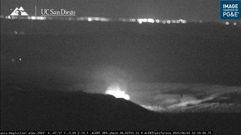
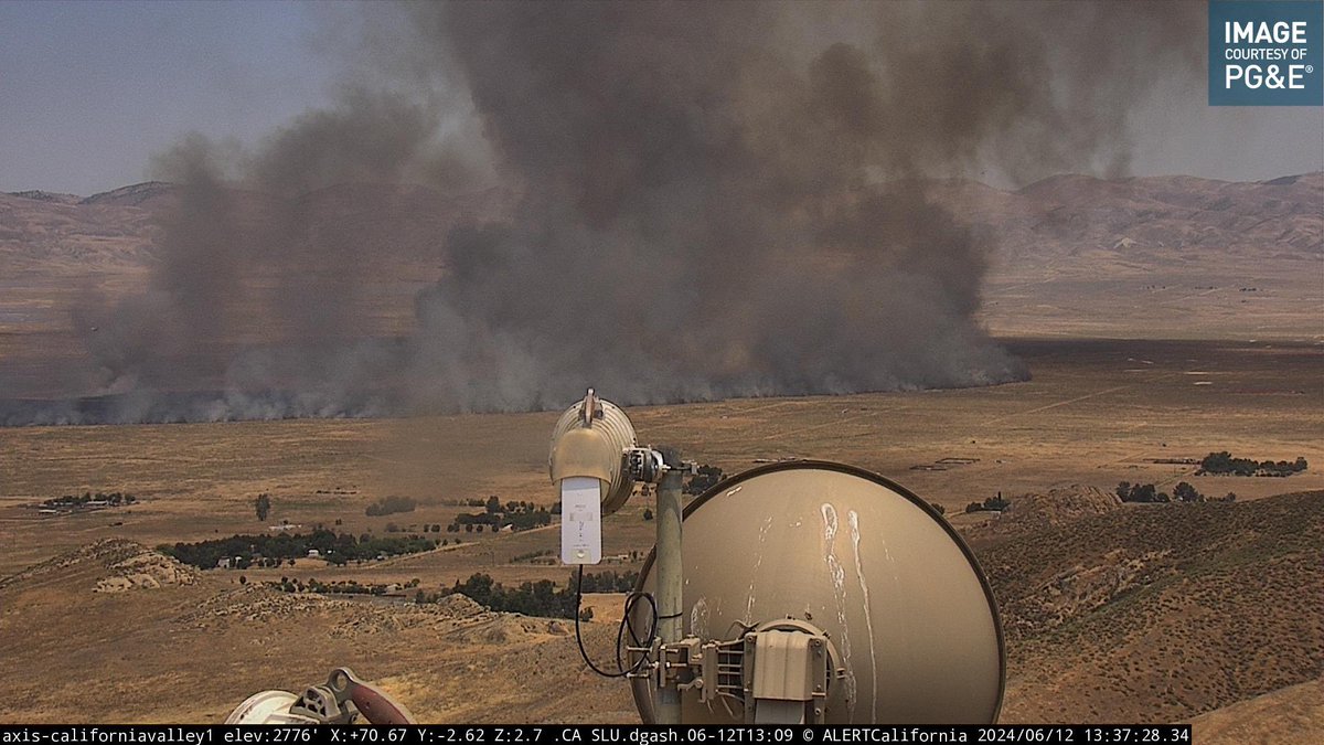
6/12/2024 #BearFire 13000 Block of Soda Lake Road, Santa Margarita, San Luis Obispo County. app.watchduty.org/#/i/21624 [WATCHDUTY] 12:16PM Reported vegetation fire with smoke visible on the fire cameras. Resources enroute. Location is subject to change.
![CodeRed001Blue's tweet image. 6/12/2024 #BearFire 13000 Block of Soda Lake Road, Santa Margarita, San Luis Obispo County. app.watchduty.org/#/i/21624 [WATCHDUTY]
12:16PM Reported vegetation fire with smoke visible on the fire cameras. Resources enroute. Location is subject to change.](https://pbs.twimg.com/media/GP6Avc6bUAA_7a4.jpg)
9/26/2023 VEEGTATION FIRE #BearFire BLACK BEAR RD & BELMONT TRL, SANTA MARGARITA San Luis Obispo County. app.watchduty.org/i/13090#allow-… [watchduty] 2:29pm Multiple units are en route to the report of a vegetation fire visible on camera ops.alertcalifornia.org/cam-console/18…
![CodeRed001Blue's tweet image. 9/26/2023 VEEGTATION FIRE #BearFire BLACK BEAR RD & BELMONT TRL, SANTA MARGARITA San Luis Obispo County. app.watchduty.org/i/13090#allow-… [watchduty]
2:29pm Multiple units are en route to the report of a vegetation fire visible on camera ops.alertcalifornia.org/cam-console/18…](https://pbs.twimg.com/media/F6_JzXWaoAAqt6U.png)
#BearFire The Fire is 2-3 acres, moving uphill, with Tree Torching ongoing, no Structures Threatened.
Correction - no structures have been damaged by the #BearFire on Bear Rd. One home is threatened and being actively protected by fire personnel. 4 other homes have been evacuated; pre-evac for additional homes in the area remains in effect. Fire is 7-8 acres in size.

#BearFire Aircraft Assisting. Air Attack 07, 1 Lead Plane, OES Intel 24. Air Tankers 74, 75, 78, 100, 137, Helitanker 7RA. AA07 is reporting The Fire is Moderate - Dangerous ROS, VLAT is unavailable.
The Bear Fire: Tankers put a hurtin on this thing before the sun went down. Crews should be hitting the line today. This fire is burning on Fort Apache ground in Arizona. Thanks to the subscriber who shared this 📷. #azfire #azwx #bearfire #wildfire
#BearFire, forward progress stopped. 131 ac. Per Cochise County Sheriff's Office SET notices remain in effect. ***All pre-evacuation or evacuation updates will come from CCSO*** Air & ground resources made good progress on the fire today. Hand crews continue to work on
This is the #BearFire in Bear Valley Road, Loyalton, Sierra County, Limited information, mapped at 64 acres, High ROS. Aircraft Assisting. Air Attack 230, OES Intel 12. Air Tankers 03, 82, 88, 89, 95, 122, 210, 809, 830, 840, 868.

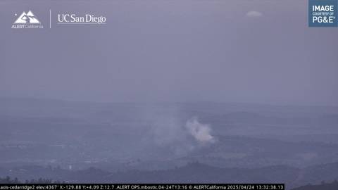
6/2/2024 VEGETATION FIRE #BearFire 5600 Block of Bear Trap Lane, Mariposa County. app.watchduty.org/#/i/20735 [WATCHDUTY] 11:09AM Reported vegetation fire with smoke visible on the fire cameras. Resources enroute.
![CodeRed001Blue's tweet image. 6/2/2024 VEGETATION FIRE #BearFire 5600 Block of Bear Trap Lane, Mariposa County. app.watchduty.org/#/i/20735 [WATCHDUTY]
11:09AM Reported vegetation fire with smoke visible on the fire cameras. Resources enroute.](https://pbs.twimg.com/media/GPGWAVrbsAAcA-S.jpg)
Something went wrong.
Something went wrong.
United States Trends
- 1. JP Morgan N/A
- 2. Resident Evil N/A
- 3. Term N/A
- 4. Toy Story N/A
- 5. Ryan Walker N/A
- 6. FLY ME OUT N/A
- 7. Platner N/A
- 8. Melendez N/A
- 9. Human Nature N/A
- 10. Maine N/A
- 11. Foles N/A
- 12. Man in the Mirror N/A
- 13. Collins N/A
- 14. Austin Slater N/A
- 15. Luke Weaver N/A
- 16. Brandon Young N/A
- 17. Surgeon General N/A
- 18. Casey Means N/A
- 19. Cregger N/A
- 20. Rick Fox N/A