#dynamicmaps search results

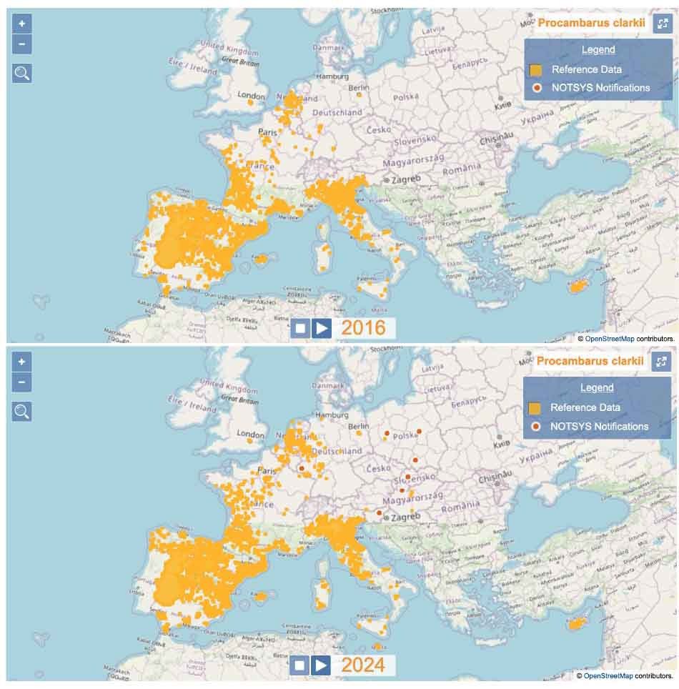
EASIN is glad to announce that a new tool has been released🥳! Do you want to know how the distribution of #InvasiveAlienSpecies of Union Concern has changed over time? Try the new #DynamicMaps 🌍(europa.eu/!pB3xFv). More information available at 👉🏻 europa.eu/!m8MxK8

All set up at #GeoCom2023 If you are planning a visit today come along and have a chat. #DynamicMAPS #DynamicAIM #Cadline


MapThat – Simple Search - Zoom to Per Layer Did you know? The DynamicMaps team have updated MapThat so that when you use the Simple Search Tool,… Read more: eu1.hubs.ly/H0myPqn0 #ARKANCE #MAPThat #DynamicMAPS

MapThat – Basemap Ordering Question: Is it possible to define the order that Basemaps are shown in the Basemap Picker? Answer: eu1.hubs.ly/H0mty0x0 #ARKANCE #MapThat #DynamicMaps

Did you know? The #DynamicMaps team have updated #MapThat so that when you use the Simple Search Tool,… and hide the search tool back and then re-open it,.. instead of removing the Blue Pin, we now retain the Blue Pin in the map! Read more: eu1.hubs.ly/H0mvr5X0 #ARKANCE


Tired of static maps that just gather dust? Buckle up, because Dynamic Maps are here to revolutionize the way we see and experience our cities! 🗺️ #dynamicmaps #thrivingneighborhoods #citypulse #CommunityPowered #cocreatethefuture #assetmap #AssetMapping #assetmappr #DynamicMap

GeoServer– Categorise Question: How do you use the Categorise option in GeoServer? Answer: ow.ly/ChC050Tv7br #DynamicMAPS #GIS

MapThat Scale Print – None Type Upper Question: What is the cause of the Scale Print Error – None Type Upper? Answer: ow.ly/UgJm50Tv9LF #MapThat #DynamicMAPS

MapThat & GeoServer – Apply a CQL Filter Part 2 Question: Does MapThat allow you to apply CQL Filters to WMS Layers? Answer: ow.ly/Ngc450Tv8ji #MapThat #DynamicMAPS

QGIS – Calculate Geometry Plugin Did You Know: There is a free plugin for QGIS that allows you to calculate the geometry of your map objects! Read more: eu1.hubs.ly/H0jt8kf0 #ARKANCE #DynamicMAPs

MapThat – SQL Builder Tool The #DynamicMaps team at Arkance UK are pleased to announce that in the latest release of our webGIS – #MapThat – we have a new SQL Builder Tool. Read more: ow.ly/QjZc50Tv9yZ

MapThat – Area Search Updates The #DynamicMaps team at ARKANCE is pleased to announce that in the latest release of our webGIS – MapThat – we have now updated the Area Search tool! Read more: ow.ly/EInG50T7eye

QGIS – Precision Zooming Did You Know: When you push your mouse wheel forward in QGIS, the map zooms in…. Read more: eu1.hubs.ly/H0jndr30 #ARKANCE #GIS #DynamicMAPS #QGIS

QGIS – World Map Did You Know: When you open QGIS the map is empty! … and the quickest way to add a map is to type the magic word … Read more: eu1.hubs.ly/H0jkjcr0 #GIS #DynamicMAPS #QGIS

QGIS – Reorder Fields in New GeoPackage In QGIS 3.40 and onwards you can re-order fields when you create a New GeoPackage file. Read more: ow.ly/w3tq50UYv1a #ARKANCE #DynamicMaps #QGIS #GIS #Mapping #DataVisualization

QGIS – Attribute Table show Visible QGIS allows you to view both Map Features and Attributes for your GIS files - using the Attribute Table tool. Read more: ow.ly/ITLV50UYvu1 #ARKANCE #DynamicMaps #QGIS #GIS #Mapping

Address & Street Management – Search Tip! Here is a tip when using the search tool within the DynamicMaps Address & Street Management Application. Read more: ow.ly/nw7T50VrnhB #ARKANCE #DynamicMAPS #GIS

QGIS – Autosize Columns In QGIS 3.40 and onwards its very easy to quickly resize the width of columns to fit the data within those columns. Read more: ow.ly/TtmS50UYuPu #ARKANCE #DynamicMAPS #QGIS #GIS

Street Naming & Numbering – Case Officer Did You Know that the DynamicMaps Street Naming and Numbering Application has now been updated to allow you to record and then search by Case Officer? Read more: ow.ly/bfUq50Vrnrp #ARKANCE #DynamicMAPS #GIS

MapThat – Simple Search - Zoom to Per Layer Did you know? The DynamicMaps team have updated MapThat so that when you use the Simple Search Tool,… Read more: eu1.hubs.ly/H0myPqn0 #ARKANCE #MAPThat #DynamicMAPS
Did you know? The #DynamicMaps team have updated #MapThat so that when you use the Simple Search Tool,… and hide the search tool back and then re-open it,.. instead of removing the Blue Pin, we now retain the Blue Pin in the map! Read more: eu1.hubs.ly/H0mvr5X0 #ARKANCE
MapThat – Basemap Ordering Question: Is it possible to define the order that Basemaps are shown in the Basemap Picker? Answer: eu1.hubs.ly/H0mty0x0 #ARKANCE #MapThat #DynamicMaps
QGIS – Precision Zooming Did You Know: When you push your mouse wheel forward in QGIS, the map zooms in…. Read more: eu1.hubs.ly/H0jndr30 #ARKANCE #GIS #DynamicMAPS #QGIS
QGIS – Calculate Geometry Plugin Did You Know: There is a free plugin for QGIS that allows you to calculate the geometry of your map objects! Read more: eu1.hubs.ly/H0jt8kf0 #ARKANCE #DynamicMAPs
QGIS – World Map Did You Know: When you open QGIS the map is empty! … and the quickest way to add a map is to type the magic word … Read more: eu1.hubs.ly/H0jkjcr0 #GIS #DynamicMAPS #QGIS
Street Naming & Numbering – Case Officer Did You Know that the DynamicMaps Street Naming and Numbering Application has now been updated to allow you to record and then search by Case Officer? Read more: ow.ly/bfUq50Vrnrp #ARKANCE #DynamicMAPS #GIS
Address & Street Management – Search Tip! Here is a tip when using the search tool within the DynamicMaps Address & Street Management Application. Read more: ow.ly/nw7T50VrnhB #ARKANCE #DynamicMAPS #GIS
MapThat – Context Menu The DynamicMaps team at Arkance UK are pleased to announce that our web Mapping Solution – MapThat – has an update to now provide a Context Menu for your Layers. Read full article: ow.ly/HAiF50VrmUn #ARKANCE #MapThat #DynamicMAPS #GIS

QGIS – Attribute Table show Visible QGIS allows you to view both Map Features and Attributes for your GIS files - using the Attribute Table tool. Read more: ow.ly/ITLV50UYvu1 #ARKANCE #DynamicMaps #QGIS #GIS #Mapping
QGIS – Reorder Fields in New GeoPackage In QGIS 3.40 and onwards you can re-order fields when you create a New GeoPackage file. Read more: ow.ly/w3tq50UYv1a #ARKANCE #DynamicMaps #QGIS #GIS #Mapping #DataVisualization
MapThat – Dynamic Clustering The DynamicMaps team at Arkance UK are pleased to announce that our web Mapping Solution – MapThat – has an update to Clustering of Map Layers ... Read more: ow.ly/GTjy50UYuZt #ARKANCE #DynamicMaps #MapThat #GIS

QGIS – Autosize Columns In QGIS 3.40 and onwards its very easy to quickly resize the width of columns to fit the data within those columns. Read more: ow.ly/TtmS50UYuPu #ARKANCE #DynamicMAPS #QGIS #GIS
The DynamicMaps team at Arkance UK are pleased to announce that our Mobile Mapping Solution – MapThat Mobile – is now available to download in the Apple App Store - ow.ly/jBQ550UMsiA #ARKANCE #MobileMapping #DynamicMaps #MapThatMobile

The DynamicMaps team at Arkance UK are pleased to announce that our Mobile Mapping Solution – MapThat Mobile – is now available to download in the Apple App Store - ow.ly/jBQ550UMsiA #ARKANCE #MobileMapping #DynamicMaps #MapThatMobile

MapThat – SQL Builder Tool The #DynamicMaps team at Arkance UK are pleased to announce that in the latest release of our webGIS – #MapThat – we have a new SQL Builder Tool. Read more: ow.ly/QjZc50Tv9yZ
MapThat Scale Print – None Type Upper Question: What is the cause of the Scale Print Error – None Type Upper? Answer: ow.ly/UgJm50Tv9LF #MapThat #DynamicMAPS
MapThat & GeoServer – Apply a CQL Filter Part 2 Question: Does MapThat allow you to apply CQL Filters to WMS Layers? Answer: ow.ly/Ngc450Tv8ji #MapThat #DynamicMAPS
GeoServer– Categorise Question: How do you use the Categorise option in GeoServer? Answer: ow.ly/ChC050Tv7br #DynamicMAPS #GIS

Whether in malls, airports, or hospitals, interactive wayfinding elevates the customer experience like never before. Learn more and see how digital signage can work for you at playsignage.com! #InteractiveWayfinding #DynamicMaps #DigitalSignage #PlayDigitalSignage


EASIN is glad to announce that a new tool has been released🥳! Do you want to know how the distribution of #InvasiveAlienSpecies of Union Concern has changed over time? Try the new #DynamicMaps 🌍(europa.eu/!pB3xFv). More information available at 👉🏻 europa.eu/!m8MxK8
All set up at #GeoCom2023 If you are planning a visit today come along and have a chat. #DynamicMAPS #DynamicAIM #Cadline
GeoServer– Categorise Question: How do you use the Categorise option in GeoServer? Answer: ow.ly/ChC050Tv7br #DynamicMAPS #GIS
MapThat Scale Print – None Type Upper Question: What is the cause of the Scale Print Error – None Type Upper? Answer: ow.ly/UgJm50Tv9LF #MapThat #DynamicMAPS
MapThat & GeoServer – Apply a CQL Filter Part 2 Question: Does MapThat allow you to apply CQL Filters to WMS Layers? Answer: ow.ly/Ngc450Tv8ji #MapThat #DynamicMAPS
MapThat – SQL Builder Tool The #DynamicMaps team at Arkance UK are pleased to announce that in the latest release of our webGIS – #MapThat – we have a new SQL Builder Tool. Read more: ow.ly/QjZc50Tv9yZ
QGIS – Calculate Geometry Plugin Did You Know: There is a free plugin for QGIS that allows you to calculate the geometry of your map objects! Read more: eu1.hubs.ly/H0jt8kf0 #ARKANCE #DynamicMAPs
MapThat – Basemap Ordering Question: Is it possible to define the order that Basemaps are shown in the Basemap Picker? Answer: eu1.hubs.ly/H0mty0x0 #ARKANCE #MapThat #DynamicMaps
MapThat – Simple Search - Zoom to Per Layer Did you know? The DynamicMaps team have updated MapThat so that when you use the Simple Search Tool,… Read more: eu1.hubs.ly/H0myPqn0 #ARKANCE #MAPThat #DynamicMAPS
Did you know? The #DynamicMaps team have updated #MapThat so that when you use the Simple Search Tool,… and hide the search tool back and then re-open it,.. instead of removing the Blue Pin, we now retain the Blue Pin in the map! Read more: eu1.hubs.ly/H0mvr5X0 #ARKANCE
QGIS – Precision Zooming Did You Know: When you push your mouse wheel forward in QGIS, the map zooms in…. Read more: eu1.hubs.ly/H0jndr30 #ARKANCE #GIS #DynamicMAPS #QGIS
QGIS – World Map Did You Know: When you open QGIS the map is empty! … and the quickest way to add a map is to type the magic word … Read more: eu1.hubs.ly/H0jkjcr0 #GIS #DynamicMAPS #QGIS
MapThat – Area Search Updates The #DynamicMaps team at ARKANCE is pleased to announce that in the latest release of our webGIS – MapThat – we have now updated the Area Search tool! Read more: ow.ly/EInG50T7eye
QGIS – Reorder Fields in New GeoPackage In QGIS 3.40 and onwards you can re-order fields when you create a New GeoPackage file. Read more: ow.ly/w3tq50UYv1a #ARKANCE #DynamicMaps #QGIS #GIS #Mapping #DataVisualization
QGIS – Autosize Columns In QGIS 3.40 and onwards its very easy to quickly resize the width of columns to fit the data within those columns. Read more: ow.ly/TtmS50UYuPu #ARKANCE #DynamicMAPS #QGIS #GIS
QGIS – Attribute Table show Visible QGIS allows you to view both Map Features and Attributes for your GIS files - using the Attribute Table tool. Read more: ow.ly/ITLV50UYvu1 #ARKANCE #DynamicMaps #QGIS #GIS #Mapping
The DynamicMaps team at Arkance UK are pleased to announce that our Mobile Mapping Solution – MapThat Mobile – is now available to download in the Apple App Store - ow.ly/jBQ550UMsiA #ARKANCE #MobileMapping #DynamicMaps #MapThatMobile
Address & Street Management – Search Tip! Here is a tip when using the search tool within the DynamicMaps Address & Street Management Application. Read more: ow.ly/nw7T50VrnhB #ARKANCE #DynamicMAPS #GIS
Street Naming & Numbering – Case Officer Did You Know that the DynamicMaps Street Naming and Numbering Application has now been updated to allow you to record and then search by Case Officer? Read more: ow.ly/bfUq50Vrnrp #ARKANCE #DynamicMAPS #GIS
MapThat – Dynamic Clustering The DynamicMaps team at Arkance UK are pleased to announce that our web Mapping Solution – MapThat – has an update to Clustering of Map Layers ... Read more: ow.ly/GTjy50UYuZt #ARKANCE #DynamicMaps #MapThat #GIS
Something went wrong.
Something went wrong.
United States Trends
- 1. Veterans Day 375K posts
- 2. Woody 12.6K posts
- 3. Toy Story 5 17.3K posts
- 4. #stateofplay 5,326 posts
- 5. Nico 141K posts
- 6. Luka 84.1K posts
- 7. Gambit 41.8K posts
- 8. Travis Hunter 3,853 posts
- 9. Payne 12.1K posts
- 10. SBMM 1,459 posts
- 11. Sabonis 3,816 posts
- 12. Tish 5,255 posts
- 13. Wike 121K posts
- 14. Mavs 32.7K posts
- 15. Vets 33.4K posts
- 16. Jonatan Palacios 2,327 posts
- 17. Pat McAfee 5,523 posts
- 18. Antifa 190K posts
- 19. Weiner 4,124 posts
- 20. #JonatanVendeHumo 3,646 posts