#endmercator resultados de búsqueda

#endMercator #WebMercator #MapProjections #MapProjection #mapprojectionsarehard #projectionsarehard #gischat #ProjectionWizard


please stop using maps with mercator projection. It misrepresents russia size and therefore also its importance. #endmercator

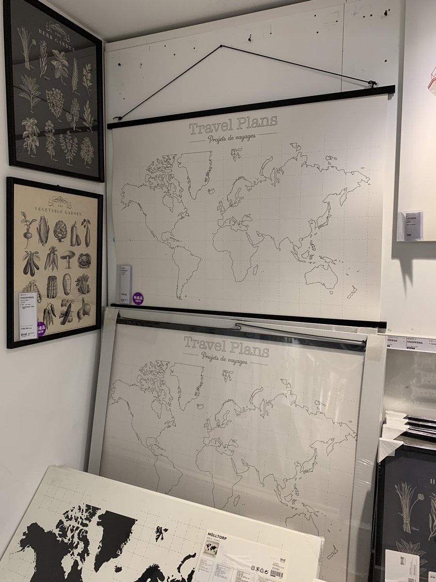
It’s 2020 and IKEA is still using Mercator Projection for all these “map arts” Arrrrrrgh my eyes #endMercator

Need to create a web #map that isn't in Web Mercator? If you are working in a local coordinate system, we can help with basemaps in a range of systems that you can use via API or WMTS: Find out how: maptiler.link/3GlAxsY #webmaps #EndMercator #GISChat
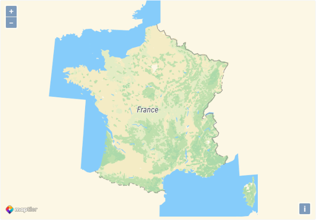
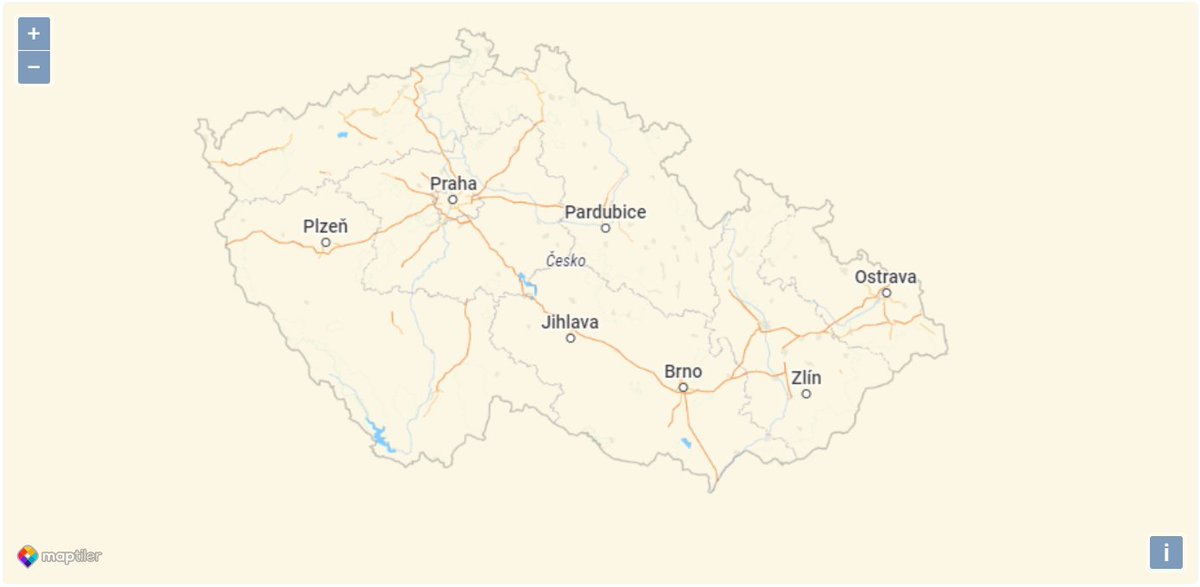
Some #maps must be made in a country's national coordinate system to be officially recognized. We have made basemaps ready to use for France, Netherlands, Czechia, and Switzerland in their national coordinate systems. Read more: maptiler.link/34poj5T #EndMercator #webmapping

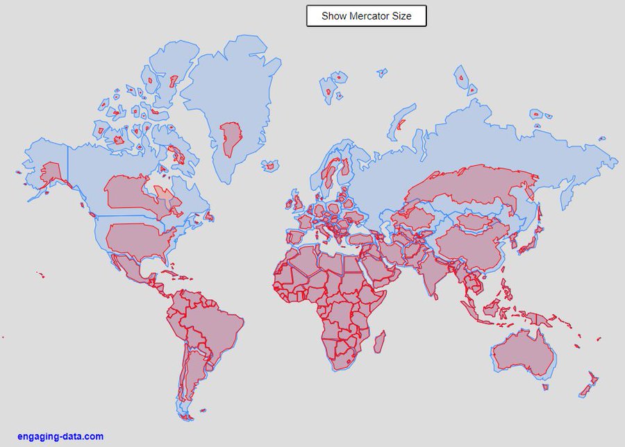
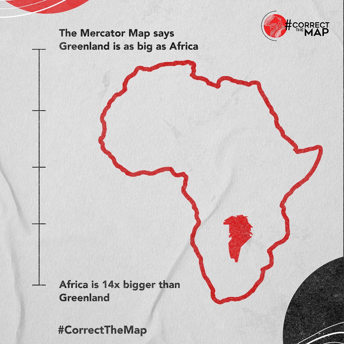
Facts are facts! Total area of Greenland: 2,166,086km Total area of Africa: 30,365,000km Yet, both are depicted the same on map projections? Make it make sense. It’s time to start living the truth. Sign the petition today, change.org/p/correctthema… #CorrectTheMap #EndMercator…
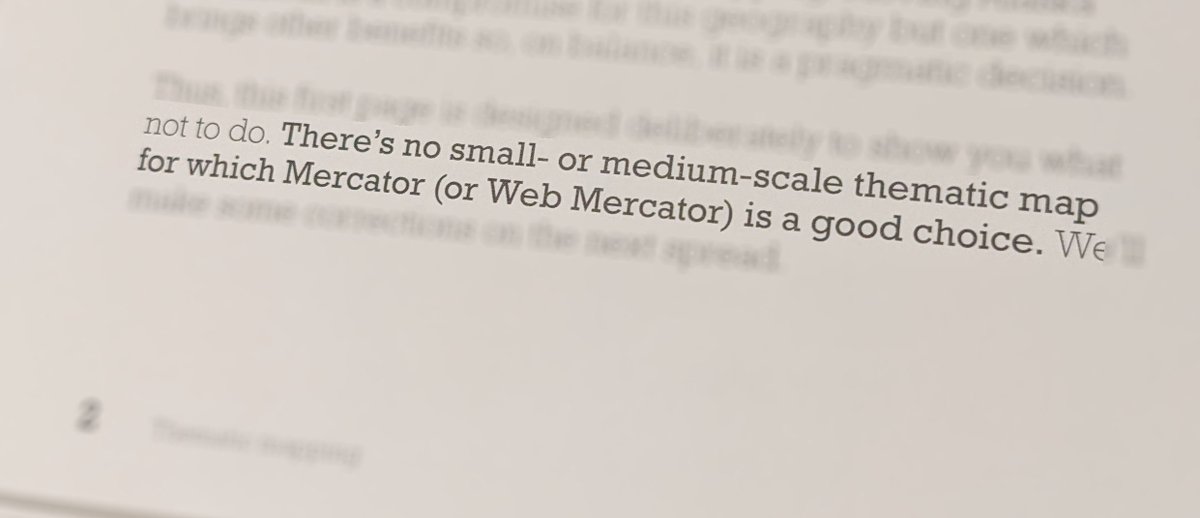
Last night, I had a privilege to flip through #ThematicMapping book by @kennethfield. As every good book on #cartography, it starts with a very solid and clear statement. #endMercator #mapprojecions #mapprojectionsarehard #ThisIsMyTruthTellMeYours
#EsriUC is about one week away. One on-demand session will be about #WebMercator. Click and find out how you can make better choices; and how you can set up a web map to use your favorite coordinate system. 🌐 @Esri @ArcGISOnline @ArcGISJSAPI #endMercator #mapprojectionsarehard


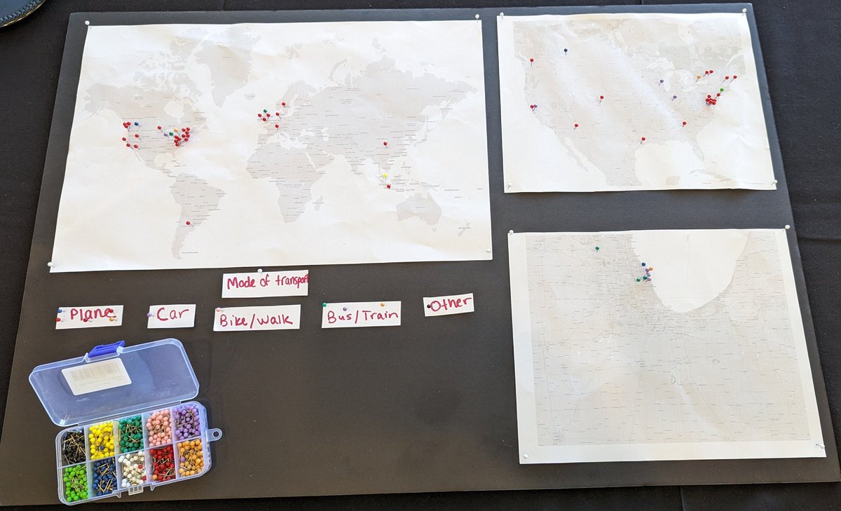
In a world of digital it's nice to see a good old fashioned physical pin map for #outlier2024 attendees. Couple of issues... I came by car, plane, train and foot so what colour pin do I use? And let's talk about the projection... #endMercator
Mapping #utilities can be very sensitive and often requires you to #map in specific coordinate systems. MapTiler lets you map in local coordinate systems, avoiding the risk of converting data. Read more: maptiler.link/3hPkcCU #EndMercator #webmapping
Cadastral Mapping can be very sensitive and often requires you to #map in specific coordinate systems. MapTiler lets you map in local coordinate systems, avoiding the risk of converting data. Read more: maptiler.link/35zVqEj #EndMercator #webmapping #cadaster
We hate seeing scanned #maps warped beyond recognition to fit with Web Mercator! MapTiler provides basemaps in other coordinate systems, so you don't have to ruin your scans to get them on the web. Read more: maptiler.link/3s0c2O6 #EndMercator #webmapping
I've been making web maps with non-Web Mercator projections for over a decade because it's not difficult. But now it's even easier, & there's no excuse not to use a more appropriate projection, as my friend & colleague Andy Skinner explains #endMercator esri.com/arcgis-blog/pr…
esri.com
Beyond Web Mercator: Building basemaps in different projections
Using ArcGIS Pro to build ArcGIS Online vector basemaps in different projections
Planes don't disappear when they fly over the poles, so why should your #map? Web Mercator only goes as far as 85° north and south, so try our WGS84 basemap for mapping at the poles. Find out how: maptiler.link/3GyO4xF #webmaps #EndMercator
Web Mercator #maps are easy, but they really exaggerate the size of the countries nearest the poles. Why not try our #WGS84 basemap for showing countries with more realistic areas. Find out how: maptiler.link/34PoU0Y #EndMercator #webmaps

Greenland is smaller than Algeria, and about 1/14 the size of Africa. Now, at long last, @googlemaps shows it like that. #EndMercator theverge.com/2018/8/5/17653… Obligatory reference: xkcd.com/977/ Fans of the TV show The West Wing will rejoice!


This is a great improvement in Apple Maps on iOS 15: the Mercator projection is gone! No more flat earth of distorted, unfair proportions. #ios15 #AppleMaps


Not Mercator, not Gall-Peters, not on Greenwich, but rather inspired by #EqualEarthProjection, with the option to arrange the map in one of three possible ways depending on how consumers see the world. Bravo @LEGO_Group! Bravo! 👏👏👏 #endMercator #mapprojections #mapprojection
Just had it confirmed that the new #Lego world map is based on the #equalearthprojection. They stretched it a bit to fit the tiles but surely this is the pinnacle for @BojanSavric @MtnMapper & @mappingbernie. Your work got made into Lego!!!
Facts are facts! Total area of Greenland: 2,166,086km Total area of Africa: 30,365,000km Yet, both are depicted the same on map projections? Make it make sense. It’s time to start living the truth. Sign the petition today, change.org/p/correctthema… #CorrectTheMap #EndMercator…
In a world of digital it's nice to see a good old fashioned physical pin map for #outlier2024 attendees. Couple of issues... I came by car, plane, train and foot so what colour pin do I use? And let's talk about the projection... #endMercator
please stop using maps with mercator projection. It misrepresents russia size and therefore also its importance. #endmercator
I should be clear that I am joking. But I was horrified to see that projection used in the closing plenary. I mean, if WE can't do better then what hope for persuading others to #endMercator
I've been making web maps with non-Web Mercator projections for over a decade because it's not difficult. But now it's even easier, & there's no excuse not to use a more appropriate projection, as my friend & colleague Andy Skinner explains #endMercator esri.com/arcgis-blog/pr…
esri.com
Beyond Web Mercator: Building basemaps in different projections
Using ArcGIS Pro to build ArcGIS Online vector basemaps in different projections
Last night, I had a privilege to flip through #ThematicMapping book by @kennethfield. As every good book on #cartography, it starts with a very solid and clear statement. #endMercator #mapprojecions #mapprojectionsarehard #ThisIsMyTruthTellMeYours
Mapping #utilities can be very sensitive and often requires you to #map in specific coordinate systems. MapTiler lets you map in local coordinate systems, avoiding the risk of converting data. Read more: maptiler.link/3hPkcCU #EndMercator #webmapping
Cadastral Mapping can be very sensitive and often requires you to #map in specific coordinate systems. MapTiler lets you map in local coordinate systems, avoiding the risk of converting data. Read more: maptiler.link/35zVqEj #EndMercator #webmapping #cadaster
Web Mercator #maps are easy, but they really exaggerate the size of the countries nearest the poles. Why not try our #WGS84 basemap for showing countries with more realistic areas. Find out how: maptiler.link/34PoU0Y #EndMercator #webmaps
We hate seeing scanned #maps warped beyond recognition to fit with Web Mercator! MapTiler provides basemaps in other coordinate systems, so you don't have to ruin your scans to get them on the web. Read more: maptiler.link/3s0c2O6 #EndMercator #webmapping
Some #maps must be made in a country's national coordinate system to be officially recognized. We have made basemaps ready to use for France, Netherlands, Czechia, and Switzerland in their national coordinate systems. Read more: maptiler.link/34poj5T #EndMercator #webmapping
Planes don't disappear when they fly over the poles, so why should your #map? Web Mercator only goes as far as 85° north and south, so try our WGS84 basemap for mapping at the poles. Find out how: maptiler.link/3GyO4xF #webmaps #EndMercator
Need to create a web #map that isn't in Web Mercator? If you are working in a local coordinate system, we can help with basemaps in a range of systems that you can use via API or WMTS: Find out how: maptiler.link/3GlAxsY #webmaps #EndMercator #GISChat
I agree. Specially because his map is in #WebMercator. 🤣🤣🤣🤪 #endMercator
#endMercator #WebMercator #MapProjections #MapProjection #mapprojectionsarehard #projectionsarehard #gischat #ProjectionWizard
This is a great improvement in Apple Maps on iOS 15: the Mercator projection is gone! No more flat earth of distorted, unfair proportions. #ios15 #AppleMaps
Not Mercator, not Gall-Peters, not on Greenwich, but rather inspired by #EqualEarthProjection, with the option to arrange the map in one of three possible ways depending on how consumers see the world. Bravo @LEGO_Group! Bravo! 👏👏👏 #endMercator #mapprojections #mapprojection
Just had it confirmed that the new #Lego world map is based on the #equalearthprojection. They stretched it a bit to fit the tiles but surely this is the pinnacle for @BojanSavric @MtnMapper & @mappingbernie. Your work got made into Lego!!!
#endMercator #WebMercator #MapProjections #MapProjection #mapprojectionsarehard #projectionsarehard #gischat #ProjectionWizard
please stop using maps with mercator projection. It misrepresents russia size and therefore also its importance. #endmercator
Need to create a web #map that isn't in Web Mercator? If you are working in a local coordinate system, we can help with basemaps in a range of systems that you can use via API or WMTS: Find out how: maptiler.link/3GlAxsY #webmaps #EndMercator #GISChat
#EsriUC is about one week away. One on-demand session will be about #WebMercator. Click and find out how you can make better choices; and how you can set up a web map to use your favorite coordinate system. 🌐 @Esri @ArcGISOnline @ArcGISJSAPI #endMercator #mapprojectionsarehard
Last night, I had a privilege to flip through #ThematicMapping book by @kennethfield. As every good book on #cartography, it starts with a very solid and clear statement. #endMercator #mapprojecions #mapprojectionsarehard #ThisIsMyTruthTellMeYours
Some #maps must be made in a country's national coordinate system to be officially recognized. We have made basemaps ready to use for France, Netherlands, Czechia, and Switzerland in their national coordinate systems. Read more: maptiler.link/34poj5T #EndMercator #webmapping
Cadastral Mapping can be very sensitive and often requires you to #map in specific coordinate systems. MapTiler lets you map in local coordinate systems, avoiding the risk of converting data. Read more: maptiler.link/35zVqEj #EndMercator #webmapping #cadaster
We hate seeing scanned #maps warped beyond recognition to fit with Web Mercator! MapTiler provides basemaps in other coordinate systems, so you don't have to ruin your scans to get them on the web. Read more: maptiler.link/3s0c2O6 #EndMercator #webmapping
Mapping #utilities can be very sensitive and often requires you to #map in specific coordinate systems. MapTiler lets you map in local coordinate systems, avoiding the risk of converting data. Read more: maptiler.link/3hPkcCU #EndMercator #webmapping
It’s 2020 and IKEA is still using Mercator Projection for all these “map arts” Arrrrrrgh my eyes #endMercator
In a world of digital it's nice to see a good old fashioned physical pin map for #outlier2024 attendees. Couple of issues... I came by car, plane, train and foot so what colour pin do I use? And let's talk about the projection... #endMercator
Facts are facts! Total area of Greenland: 2,166,086km Total area of Africa: 30,365,000km Yet, both are depicted the same on map projections? Make it make sense. It’s time to start living the truth. Sign the petition today, change.org/p/correctthema… #CorrectTheMap #EndMercator…
Something went wrong.
Something went wrong.
United States Trends
- 1. Brunson 6,637 posts
- 2. Knicks 12.1K posts
- 3. Celtics 12.5K posts
- 4. Jaylen Brown 5,645 posts
- 5. Duke 28.2K posts
- 6. Jordan Walsh N/A
- 7. #WWENXT 10.5K posts
- 8. Notre Dame 34K posts
- 9. Miami 95.9K posts
- 10. Bama 22.4K posts
- 11. Van Epps 123K posts
- 12. Mikal Bridges 1,404 posts
- 13. Tennessee 209K posts
- 14. Boogie Fland N/A
- 15. Isaiah Evans 1,296 posts
- 16. Nashville 32.3K posts
- 17. Behn 74.9K posts
- 18. Cam Boozer 1,053 posts
- 19. #RHOSLC 2,569 posts
- 20. Syracuse 8,506 posts