#gischat search results

#30DayMapChallenge Day 8 - Urban A Map showing Landcover Map of Dar es salaam in which the Built up area dominates in Red ,The city has population of more than 5 million people according to NBS in which this constitute 9% of country population #gischat #Tanzania #map #qgis #b3d

#30DayMapChallenge Day 6 - Dimension A 3-D Georeferenced Map of Antarctica 🇦🇶 "Antarctica Polar Steriographic" produced by " Common Wealth Australia ",1986 edition 4 #gischat #Antarctica #SouthPole #map #qgis #b3d


Wanderlust rule #1 :If there's a #map in sight, it's coming home in my camera roll😄🗺. #Maps in the wild #gischat


Want to learn how to analyze and visualize spatial data in the social sciences? I'm now offering my Introduction to Spatial Data and R as a GIS course on #InStats in March 2025, instats.org/seminar/introd…, more courses and info at nickbearman.com/training-cours… #GISchat


I’ve created a Russian-language “Soviet atlas”-style map of Middle-earth. You can download it for free in high resolution: disk.yandex.ru/d/R8YXcS9WPtVC… #gischat


#30DayMapChallenge Day 7 - Accessibility An Isochrone Map showing Time taken from Ubungo Flyover - Dar es salaam to else where assuming there's no traffic and in driving car cause Dar es salaam has extremely huge traffic in some areas #gischat #Tanzania #map #qgis


Back in my student days, the urban design class taught a trick of adding “fake shadows” into maps quickly in Photoshop by: 1. Duplicate the building polygons 2. Offset it by a tiny distance 3. Change it to black & put it behind Same technique can be used in QGIS too #gischat


Day 6: Dimensions The UK’s remotest pub can only be reached by ferry or a 25km hike. I really want to hike this one day. #30DayMapChallenge #arcgispro #gischat #canva


Day 5 and 6 Earth and Dimension Mapped the 6 D of Culture by country #30DayMapChallenge #gischat #gismaps #gis #qgis #maps


Spatial prediction methods for geostatistical data such as disease prevalence 🪰, precipitation 🌧️, contaminants 🏭, household prices 🏡 🔗paulamoraga.com/book-spatial/s… #rstats #rspatial #GISChat


What does your "I'll just give it some rough styling to sense check it as I go" cartography say about you? #gischat Mine says disco.


It's nice to know that I'm still capable of causing trouble - my ArcGIS Idea is the number one most requested feature addressed in the new ArcGIS Pro release #gischat


I am looking for the best open-source algorithm for converting a building raster to vector without oversimplifying the outlines, something better than the minimum rotated rectangle algorithm. Let me know if you have any recommendations. Thanks. #geospatial #gischat #building…


Gave geo-projections.com a long overdue refresh Tooltips showing area distortion Tissot circles for visualization City search & map dragging Dark/Light mode Many more fixes Originally built it in 2021 while learning #d3js #cartography #gischat #maps
#30DayMapChallenge Day 8 - Urban A Map showing Landcover Map of Dar es salaam in which the Built up area dominates in Red ,The city has population of more than 5 million people according to NBS in which this constitute 9% of country population #gischat #Tanzania #map #qgis #b3d
#30DayMapChallenge Day 7 - Accessibility An Isochrone Map showing Time taken from Ubungo Flyover - Dar es salaam to else where assuming there's no traffic and in driving car cause Dar es salaam has extremely huge traffic in some areas #gischat #Tanzania #map #qgis
#30DayMapChallenge Day 6 - Dimension A 3-D Georeferenced Map of Antarctica 🇦🇶 "Antarctica Polar Steriographic" produced by " Common Wealth Australia ",1986 edition 4 #gischat #Antarctica #SouthPole #map #qgis #b3d
Day 5 and 6 Earth and Dimension Mapped the 6 D of Culture by country #30DayMapChallenge #gischat #gismaps #gis #qgis #maps
Day 5 and 6 Earth and Dimension Mapped the 6 D of Culture by country #30DayMapChallenge #gischat #gismaps #gis #qgis #maps
Day 6: Dimensions The UK’s remotest pub can only be reached by ferry or a 25km hike. I really want to hike this one day. #30DayMapChallenge #arcgispro #gischat #canva

New article! @DarlanMNunes1 & @silcamboim investigate Collaborative toponyms in OpenStreetMap evaluating the potential to complement and update National Mapping Agencies data, doi.org/10.1080/152304… also see their code and process at github.com/darlanmnunes/P… #GISchat

New paper! Fascinating discussion of Optimizing electric vehicle supply equipment allocation using a range of local and global MCDA methods by Emily Zhou & Junyi Yang, #GISchat doi.org/10.1080/152304…

New article! Fascinating article on the impact personal narratives have on making thematic maps more persuasive by Rob Davidson and James Cheshire, doi.org/10.1080/152304… #OpenAccess #GISChat


Want to learn how to analyze and visualize spatial data in the social sciences? I'm now offering my Introduction to Spatial Data and R as a GIS course on #InStats in March 2025, instats.org/seminar/introd…, more courses and info at nickbearman.com/training-cours… #GISchat
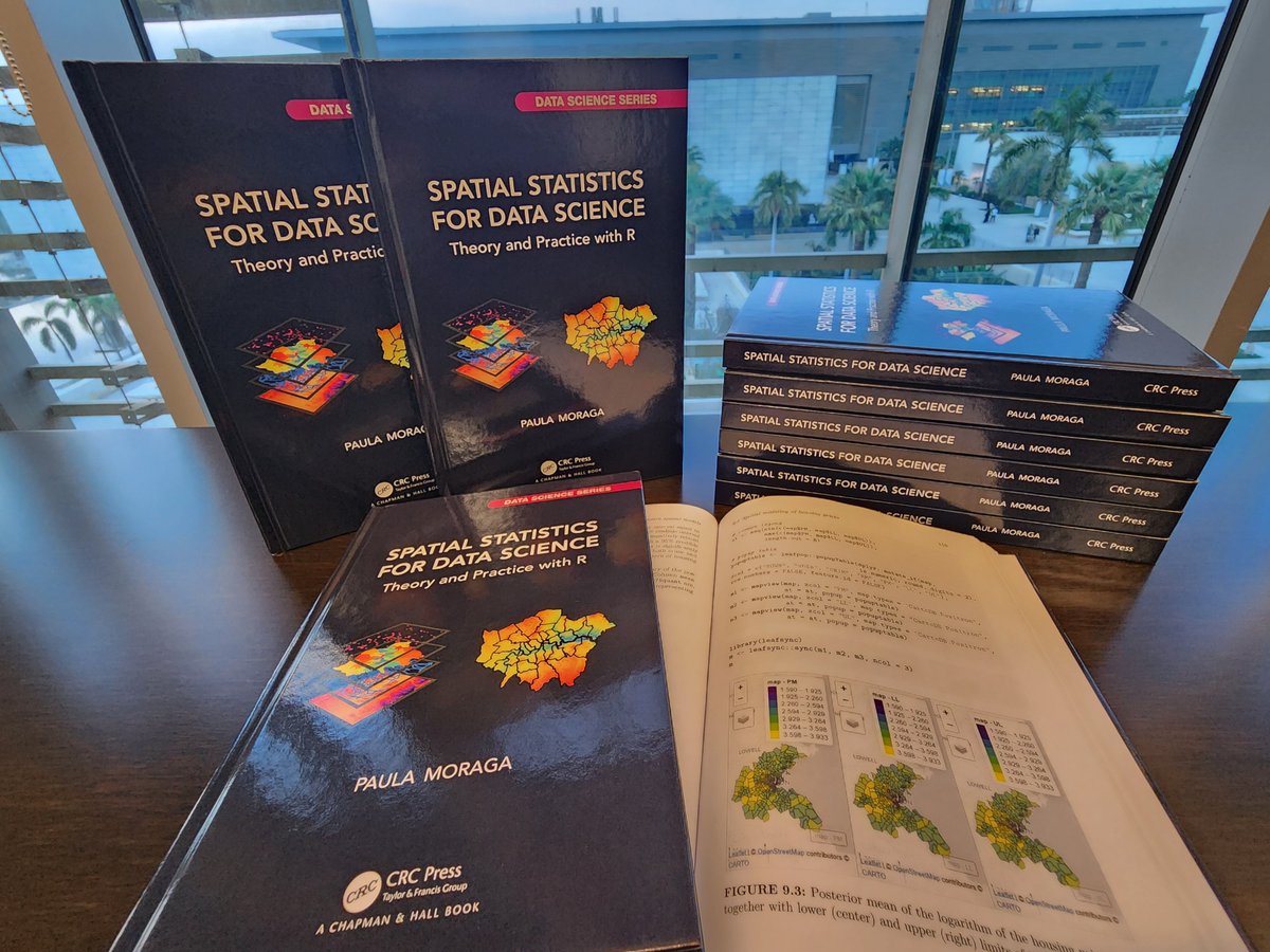
I just received the hardcopies of my book ✨ Spatial Statistics for Data Science ✨ 👉 paulamoraga.com/book-spatial/ Many thanks @CRC_MathStats! They look great! 🤩 💻#rstats 🗺️#rspatial ⚡️#gischat 📊#RINLA 📈#datascience 🌍#dataviz 🌈#epitwitter 🌿#ecology 📕 #statistics


Wanderlust rule #1 :If there's a #map in sight, it's coming home in my camera roll😄🗺. #Maps in the wild #gischat
#30DayMapChallenge Day 6 - Dimension A 3-D Georeferenced Map of Antarctica 🇦🇶 "Antarctica Polar Steriographic" produced by " Common Wealth Australia ",1986 edition 4 #gischat #Antarctica #SouthPole #map #qgis #b3d
Spatial prediction methods for geostatistical data such as disease prevalence 🪰, precipitation 🌧️, contaminants 🏭, household prices 🏡 🔗paulamoraga.com/book-spatial/s… #rstats #rspatial #GISChat
Back in my student days, the urban design class taught a trick of adding “fake shadows” into maps quickly in Photoshop by: 1. Duplicate the building polygons 2. Offset it by a tiny distance 3. Change it to black & put it behind Same technique can be used in QGIS too #gischat

🗺️ Making maps with R 🗺️ Examples of static and interactive maps and mobility flows using {ggplot2}, {leaflet}, {mapview}, {tmap} & {flowmapblue} 👉 paulamoraga.com/book-spatial/m… #rstats #rspatial #GISchat #datascience
#30DayMapChallenge Day 8 - Urban A Map showing Landcover Map of Dar es salaam in which the Built up area dominates in Red ,The city has population of more than 5 million people according to NBS in which this constitute 9% of country population #gischat #Tanzania #map #qgis #b3d
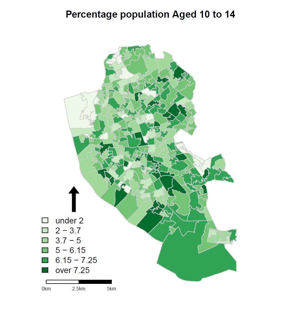
Working on slides for Intro to Spatial Data and R as a GIS course on #InStats, inc. classification & why it's important, which gives me the chance to show this great graphic from James Cheshire @spatialanalysis theconversation.com/next-slide-ple…, details at instats.org/seminar/introd… #GISchat


What does your "I'll just give it some rough styling to sense check it as I go" cartography say about you? #gischat Mine says disco.

Y es que: 'mapas vemos... organización y fuentes de datos no sabemos'. #Gischat #sig #QGIS #Arcgis #FelizViernes

Day 6: Dimensions The UK’s remotest pub can only be reached by ferry or a 25km hike. I really want to hike this one day. #30DayMapChallenge #arcgispro #gischat #canva
Something went wrong.
Something went wrong.
United States Trends
- 1. Packers 93.5K posts
- 2. Eagles 121K posts
- 3. Jordan Love 14.3K posts
- 4. #WWERaw 122K posts
- 5. Matt LaFleur 7,901 posts
- 6. AJ Brown 6,511 posts
- 7. $MONTA 1,269 posts
- 8. Jaelan Phillips 7,160 posts
- 9. Patullo 11.9K posts
- 10. #GoPackGo 7,745 posts
- 11. Smitty 5,367 posts
- 12. McManus 4,078 posts
- 13. Sirianni 4,779 posts
- 14. Grayson Allen 3,157 posts
- 15. Cavs 10.5K posts
- 16. #MondayNightFootball 1,911 posts
- 17. Pistons 14.6K posts
- 18. Devonta Smith 5,831 posts
- 19. John Cena 98.8K posts
- 20. Wiggins 11.8K posts