#mapprojection resultados da pesquisa


@roscosmos @NASAEarth @ESA_EO @CNSA_en @MtnMapper @mappingbernie #mapprojection take earth images from space, wrap it on a globe & settle Gall-Peters, Mercator, #EqualEarthProjection & all confusing nondefinitive projections. Unless the world is indeed flat This isn't accurate👇🏾


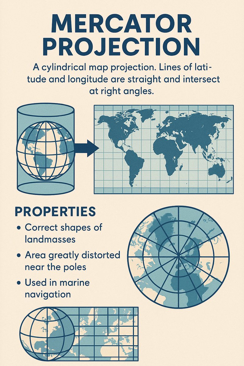
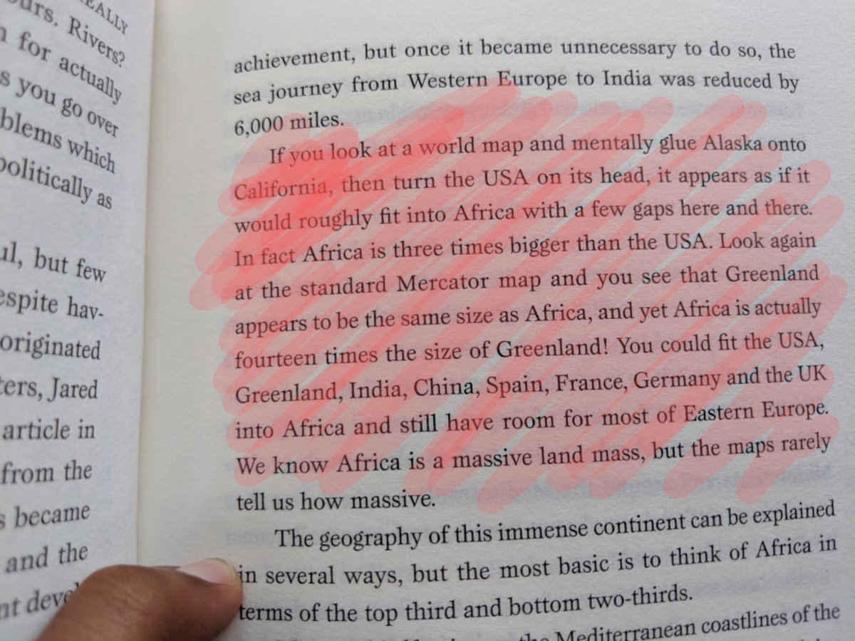
Ever wondered why Greenland looks so massive on some maps? Discover the truth behind the Mercator projection and how it distorts our view of the world! #mercatorprojection #mapprojection #geographyfacts #cartography #worldmap #spatialawareness #mapdistortion #navigationtools

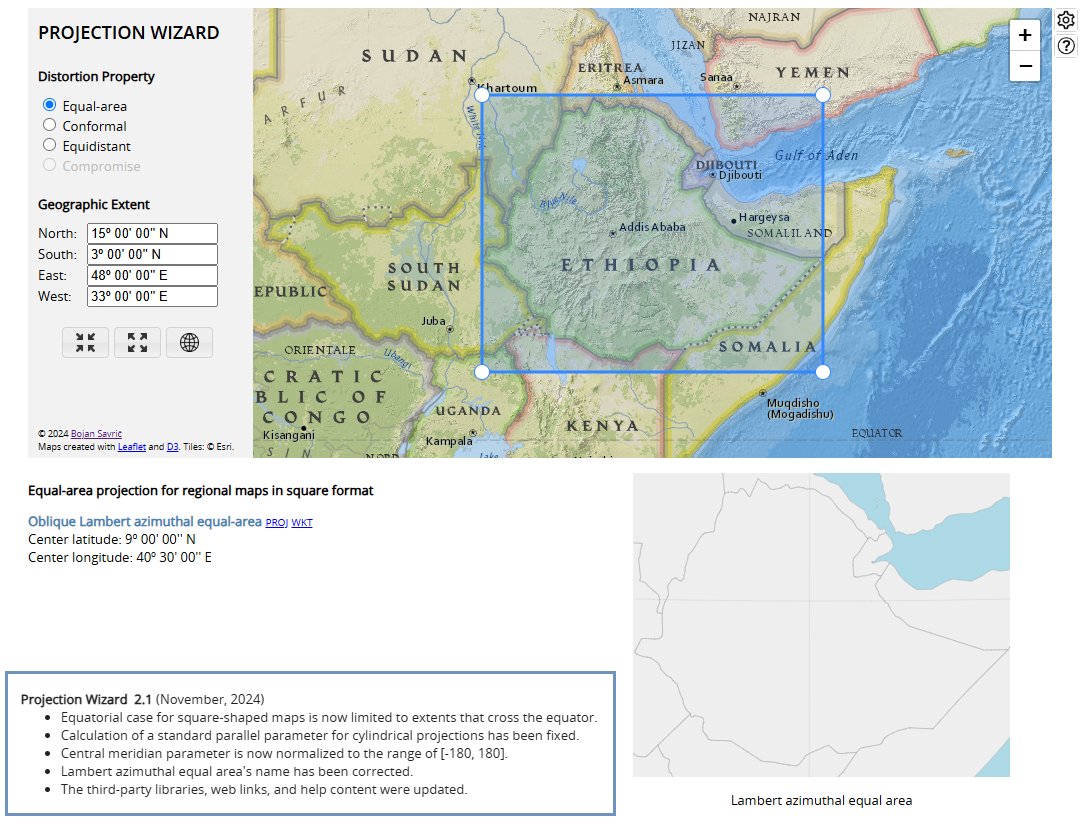
📣A new version of #ProjectionWizard v2.1 🗺️🌐🪄 is now live as of this morning. Visit projectionwizard.org #mapprojection #mapprojections #webMercator #endMercator #mapprojectionsarehard #projectionsarehard #gischat #geospatial
مفهوم #إسقاط_الخرائط #MapProjection مصدر الصورة: linkedin.com/posts/johnmnel… مواضيع ذات صله: إسقاط الخرائط x.com/geomaticsk/sta… علم إسقاط الخرائط x.com/geomaticsk/sta… الدول الأدق تمثيلا على الخريطة والعكس x.com/geomaticsk/sta…


Probably the most expensive #mapfail one can purchase. I did consider buying it because I love the concept, but not enough…😅 @HUGOBOSSSERVICE, I will be happy to provide you a free #mapprojection advice next time you want to use a #map and I will proudly wear it. #mapinthewild

"Maps are not 'innocent drawings': they are spatial narratives that orient the gaze and, by extension, policies and markets." ... "It is an invitation to rethink how we look at the world — and to choose the #mapprojection that best reflects the message we want to communicate."
Unfortunately, I couldn’t attend the #NACIS2023 this year because ‘Wild World’ #map by @AntonThomasMaps was scheduled to arrive. Oh boy, it really is a “wild” map like the #mapprojection it is in. 😍🌎🌍🌏🌐👏


Besides being in top three by publication on #gis #mapprojection topic during last 30 years, I like the company even more. cc @mappingbernie 🏆👏 Research themes of geographical information science during 1991–2020: tandfonline.com/doi/full/10.10… #mapprojectionsarehard #mapprojections

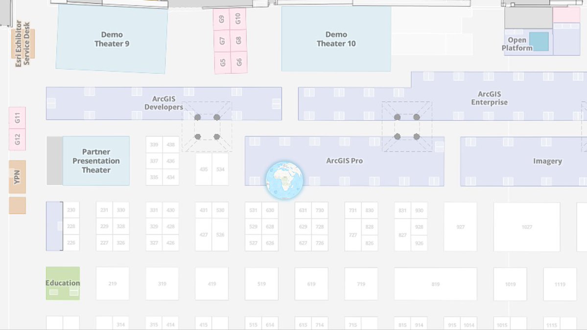
After great @EsriUC Plenary yesterday, it is time for @Esri Showcase Expo. If you have questions about coordinate systems, transformations, #MapProjections, #SpatialReference, look for #MapProjection Engine team at @ArcGISPro Coordinate Systems Expo island. #EsriUC #EsriUC2023

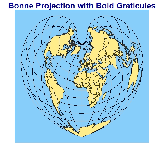
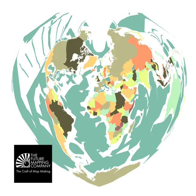
Day 26 of the #30DayMapChallenge: Bonne Projection 🌍❤️ This heart-shaped map makes me feel like I could keep iterating on projections forever—endlessly beautiful! 🌏💙 #MapProjection #GIS #MappingFun
مقدمة عن إسقاط #الخرائط 🗺️ #MapProjection من محاضرات المهندس خالد العريني drive.google.com/file/d/1hbzO1d…
Do you want your favorite #mapprojection 🌐implemented in your favorite mapping software? 🌎🌍🌏 Come to #ICC2023 session on Geospatial Data and Software this morning. I will show what you need to know. #mapprojectionsarehard #gis #mapping #mapprojections doi.org/10.5194/ica-ab…


C O M I N G S O O N New Map Alert! Here's a little teaser of a new map we have coming soon to celebrate 20 years of map making. Do you know what World map projection this is? #worldmapprojection #mapprojection #modernmap #colourfulmap #printedmaps #myfuturemap

B O N N E An Equal Area Projection The projection was creayed by Claudius Ptolemy in about A.D. 100, but it was named after Rigobert Bonne who used the projection in the mid 1700's. It's graticule takes the form of a heart. #bonneprojection #heartmap #mapprojection
M A P A R T W O R K Our new Peirce Quincuncial map is ready to print! The projection is presented with the North pole at the centre and four quadrants around this giving you a projection that can be tiled perfectly. #modernmap #mapart #mapprojection #peircequinucuncial


Here is some light reading... The new US datums of 2022 will soon be released. This #ArcGISBlog article covers what is coming and how you should prepare your data. #coordinatesystem #mapprojection #stateplane #GIS #gischat #spatial #mapping #NAD83 #NAVD88 esri.com/arcgis-blog/pr…


۱۰ له همدې امله دا پروجکشن په دقیقو سروې ګانو، جهت موندلو او انټرنټي نقشو کې نه کارول کيږي، بلکې په ښوونيزو، تعليمي او ټولنيزو چارو کې ورڅخه استفاده کيږي. #Geography #MapProjection #Cartography #GIS #MercatorProjection #RobinsonProjection #UrbanPlanning #Education #Maps
"Maps are not 'innocent drawings': they are spatial narratives that orient the gaze and, by extension, policies and markets." ... "It is an invitation to rethink how we look at the world — and to choose the #mapprojection that best reflects the message we want to communicate."
Ever wondered why Greenland looks so massive on some maps? Discover the truth behind the Mercator projection and how it distorts our view of the world! #mercatorprojection #mapprojection #geographyfacts #cartography #worldmap #spatialawareness #mapdistortion #navigationtools
مفهوم #إسقاط_الخرائط #MapProjection مصدر الصورة: linkedin.com/posts/johnmnel… مواضيع ذات صله: إسقاط الخرائط x.com/geomaticsk/sta… علم إسقاط الخرائط x.com/geomaticsk/sta… الدول الأدق تمثيلا على الخريطة والعكس x.com/geomaticsk/sta…
Day 26 of the #30DayMapChallenge: Bonne Projection 🌍❤️ This heart-shaped map makes me feel like I could keep iterating on projections forever—endlessly beautiful! 🌏💙 #MapProjection #GIS #MappingFun
📣A new version of #ProjectionWizard v2.1 🗺️🌐🪄 is now live as of this morning. Visit projectionwizard.org #mapprojection #mapprojections #webMercator #endMercator #mapprojectionsarehard #projectionsarehard #gischat #geospatial
The #mapprojection song. Guess which is their favorite one? youtube.com/shorts/FL949xc… It would be great to see the full video... 😅

youtube.com
YouTube
The map projection song
After great @EsriUC Plenary yesterday, it is time for @Esri Showcase Expo. If you have questions about coordinate systems, transformations, #MapProjections, #SpatialReference, look for #MapProjection Engine team at @ArcGISPro Coordinate Systems Expo kiosk. 🌐 #EsriUC #EsriUC2024

Change your perspective: Change the world. This bold interpretation of our globe looks modern, but was invented in 1879. Make your home a beautiful place to be inspired. ☞ bit.ly/4c0Rvx8 #worldmapprojection #mapprojection #modernmap #peircequincuncial

M A P A R T W O R K Our new Peirce Quincuncial map is ready to print! The projection is presented with the North pole at the centre and four quadrants around this giving you a projection that can be tiled perfectly. #modernmap #mapart #mapprojection #peircequinucuncial
C O M I N G S O O N New Map Alert! Here's a little teaser of a new map we have coming soon to celebrate 20 years of map making. Do you know what World map projection this is? #worldmapprojection #mapprojection #modernmap #colourfulmap #printedmaps #myfuturemap
Highcharts has TopoJSON support and built-in projection to offer smaller map files, faster loading, and more flexible map layouts. By @TorsteinHonsi Read more: highcharts.com/blog/tutorials… #Highcharts #TopoJSON #mapprojection #EqualEarth #WebMercator
مقدمة عن إسقاط #الخرائط 🗺️ #MapProjection من محاضرات المهندس خالد العريني drive.google.com/file/d/1hbzO1d…
Highcharts has TopoJSON support and built-in projection to offer smaller map files, faster loading, and more flexible map layouts. By @TorsteinHonsi Read more: highcharts.com/blog/tutorials… #Highcharts #TopoJSON #mapprojection #EqualEarth #WebMercator
Highcharts has TopoJSON support and built-in projection to offer smaller map files, faster loading, and more flexible map layouts. By @TorsteinHonsi Read more: highcharts.com/blog/tutorials… #Highcharts #TopoJSON #mapprojection #EqualEarth #WebMercator
Highcharts has TopoJSON support and built-in projection to offer smaller map files, faster loading, and more flexible map layouts. By @TorsteinHonsi Read more: highcharts.com/blog/tutorials… #Highcharts #TopoJSON #mapprojection #EqualEarth #WebMercator
Highcharts has TopoJSON support and built-in projection to offer smaller map files, faster loading, and more flexible map layouts. By @TorsteinHonsi Read more: highcharts.com/blog/tutorials… #Highcharts #TopoJSON #mapprojection #EqualEarth #WebMercator
Highcharts has TopoJSON support and built-in projection to offer smaller map files, faster loading, and more flexible map layouts. By @TorsteinHonsi Read more: highcharts.com/blog/tutorials… #Highcharts #TopoJSON #mapprojection #EqualEarth #WebMercator
Here is some light reading... The new US datums of 2022 will soon be released. This #ArcGISBlog article covers what is coming and how you should prepare your data. #coordinatesystem #mapprojection #stateplane #GIS #gischat #spatial #mapping #NAD83 #NAVD88 esri.com/arcgis-blog/pr…


the Waterman Projection source: buff.ly/2ITiqC0 #mapprojection #mapping #worldmap #geography #GIS #geospatial #geodata #datavis #geographyteacher #geo #cartography #world #topography #northamerica #southamerica #centralamerica #europe #asia #Oceania


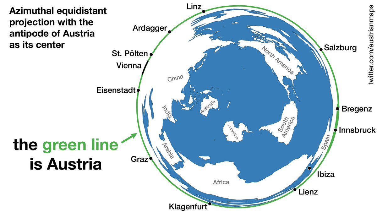
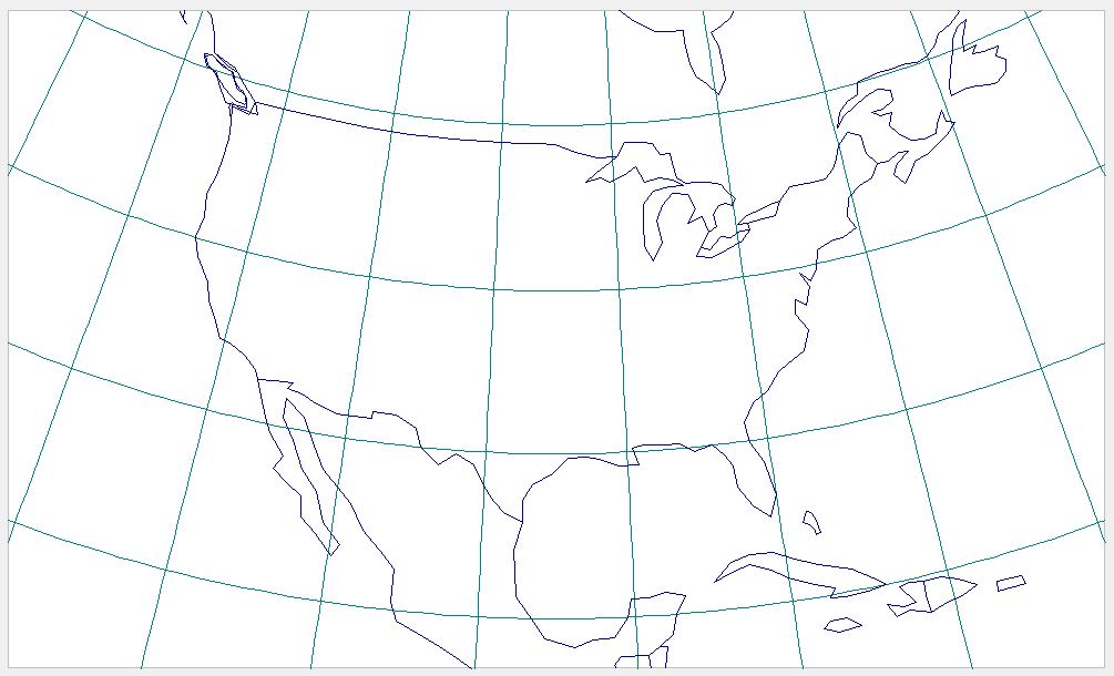
the green line is Austria (Azimuthal equidistant projection with the antipode of Austria as its center). #mapprojection
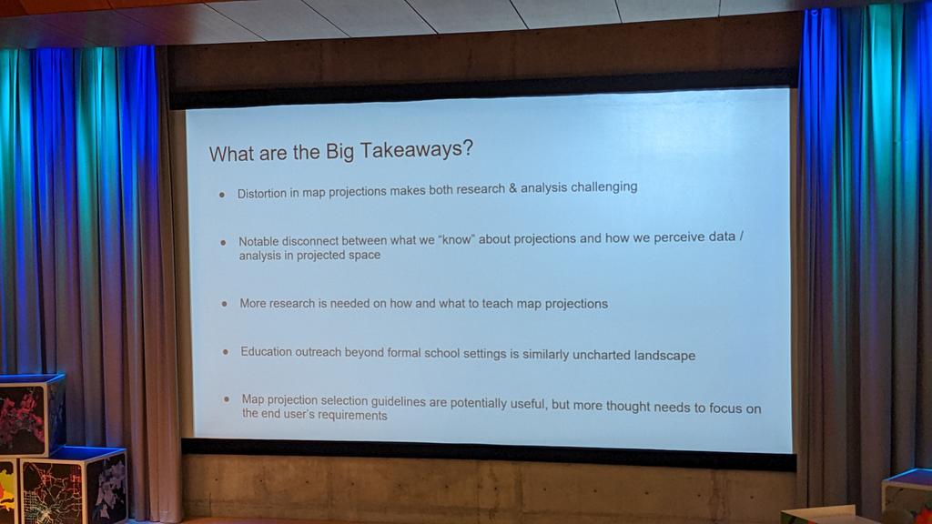
Great points and cool presentation by @mapsOverlord & @Fritz_Kessler on #mapprojection cognitive aspects at #AutoCarto2022 🌎🌍🌏🌐


There's a new help page for every #mapprojection in @ArcGISPro 2.5. See them all here: pro.arcgis.com/en/pro-app/hel…


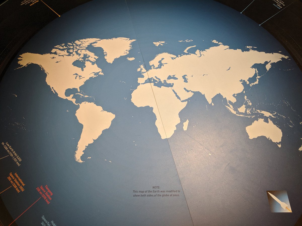
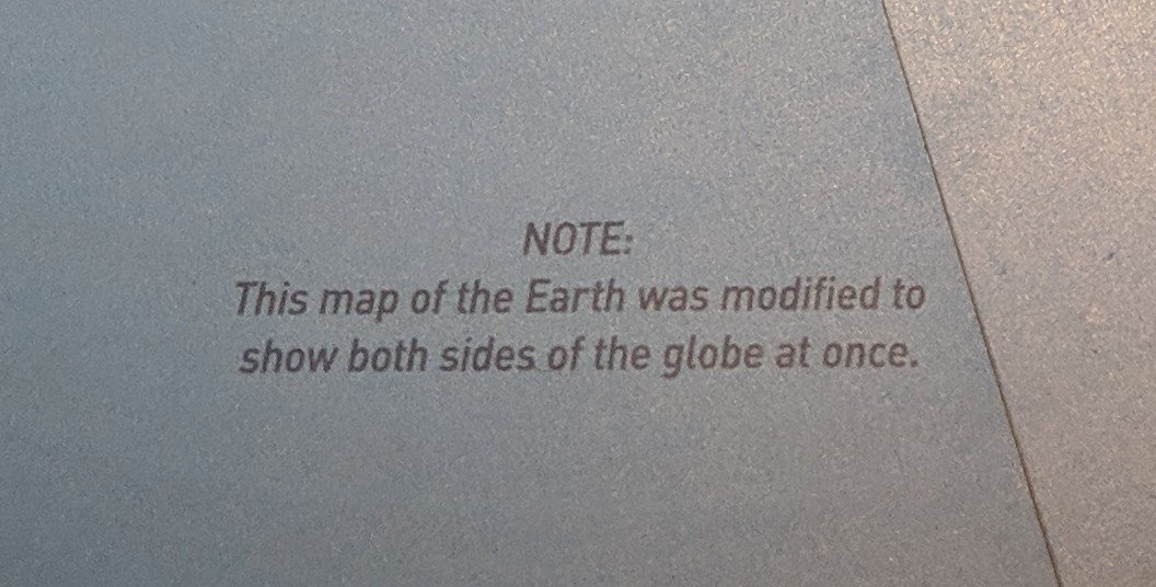
"This map of the Earth was modified to show both sides of the globe at once". I said WTF? Or as @BojanSavric said... #MAPPROJECTION


The Spilhaus World Ocean map projection map made the final edit of Map Projections for Babies! Your copies of the book are being printed as we speak! Only a few weeks until you’ll have your books in-hand! #maps #cartography #mapprojection #kidslit #boardbook

📣A new version of #ProjectionWizard v2.1 🗺️🌐🪄 is now live as of this morning. Visit projectionwizard.org #mapprojection #mapprojections #webMercator #endMercator #mapprojectionsarehard #projectionsarehard #gischat #geospatial

![USGS's tweet image. [FAQ] - How are different map projections used?
ow.ly/WYFW50Ge4pp
#mapprojection #TopographyTuesday](https://pbs.twimg.com/media/E_1u598VUAMIX8L.jpg)


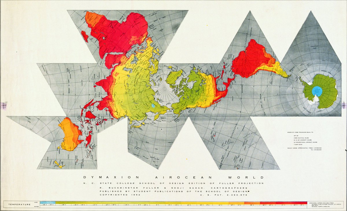
Day 25 of #30DaysOfMapProjections 🌐 Fuller, #dymaxionmap #mapprojection pro.arcgis.com/en/pro-app/hel… #mapprojectionsarehard #projectionsarehard #mapprojections


The lesson we learned and experienced in #GIS #MapProjection was also explained by @Itwitius's Prisoners of Geography book.

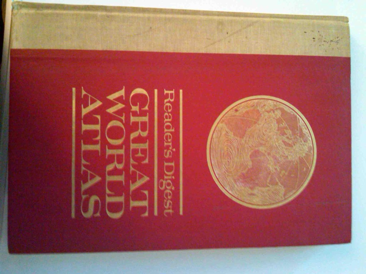
One of my personal favorites is the 1963 Reader's Digest Great World Atlas, which I grew up with, and shows much more of the world than you could ever see from space. #atlas #mapprojection


Something went wrong.
Something went wrong.
United States Trends
- 1. Yamamoto 49.2K posts
- 2. #DWTS 45K posts
- 3. halsey 9,455 posts
- 4. Young Republicans 79K posts
- 5. #MOST_WANTED_IN_CHICAGO 1,448 posts
- 6. #FlyTogether 2,995 posts
- 7. Kreider 1,358 posts
- 8. #TexasHockey 3,462 posts
- 9. Jared Butler N/A
- 10. Ohtani 14.3K posts
- 11. #Worlds2025 48.4K posts
- 12. Cuffem 2,995 posts
- 13. Lucia 62.7K posts
- 14. TOKYO NARITA N/A
- 15. Tami 4,654 posts
- 16. Vivian 29.7K posts
- 17. Robert 106K posts
- 18. Will Richard 2,630 posts
- 19. Vishnu 9,126 posts
- 20. Roldan 2,713 posts