#mapsdotcom search results

If you're looking for cartographic inspiration, here are two moon maps on #mapsdotcom. The first uses artificial light to cast shadows across the jagged terrain. The second is a great example of #dataviz showing 1.3M craters more prominent than 1 km. esri.social/6gGj50QIV9F


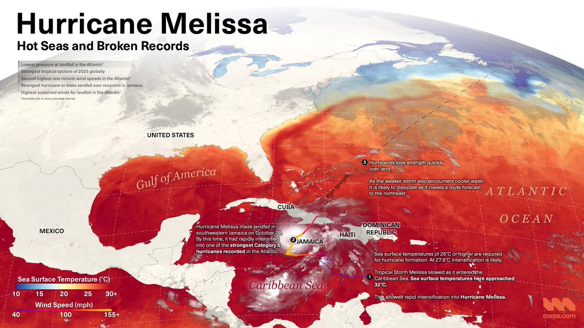
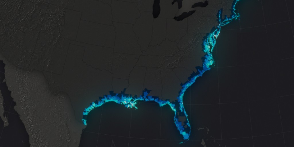
Hurricane Melissa recently battered Jamaica and the Caribbean. Learn how hot seas led to a record-breaking storm in this new map from #MapsDotCom: ow.ly/HVY150Xm4iS

Find the perfect campsite, navigate the next bend in the river, and discover the heavens from both the Northern and Southern Hemispheres with detailed star charts. Find your path at @mapsdotcom bit.ly/3hTKLax #sponsored @getoutmore #mapsdotcom #summerofwhere


Anyone familiar with geography and health knows about John Snow and the mapping of cholera. What if what you know is wrong? Snow Mistake: Correcting Myths in the Mapping of Cholera ow.ly/49Ic50W863e #mapsdotcom


🐠🪸Coral reefs, the “canaries in the coal mine” for ocean health, are at risk of bleaching due to rising temperatures. Thanks to @NOAA’s Coral Reef Watch, we can monitor and protect these vital #ecosystems. Dive into the #interactivemap on #mapsdotcom. ow.ly/8o4r50Rufce


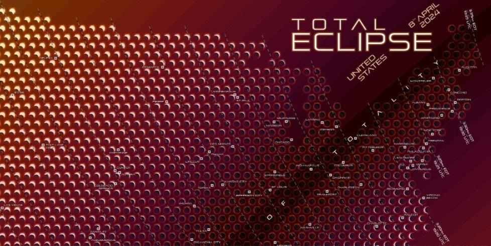
Where will you be on April 8? If you want to catch the solar eclipse at the right time, this striking map by @kennethfield on #mapsdotcom shows when and where totality will occur. 🌒☀️ #eclipse2024 ow.ly/CQGU50RaNwe

🐠🪸Coral reefs, the “canaries in the coal mine” for ocean health, are at risk of bleaching due to rising temperatures. Thanks to @NOAA’s Coral Reef Watch, we can monitor and protect these vital #ecosystems. Dive into the #interactivemap on #mapsdotcom. ow.ly/c0VV50RymSr

🐠🪸Coral reefs, the “canaries in the coal mine” for ocean health, are at risk of bleaching due to rising temperatures. Thanks to @NOAA’s Coral Reef Watch, we can monitor and protect these vital #ecosystems. Dive into the #interactivemap on #mapsdotcom. ow.ly/sSWe50RymSc

Everybody needs a map. Get your next adventure dialed in with a quality @mapsdotcom trail and hiking map. bit.ly/3gHJMsE @getoutmore #mapsdotcom


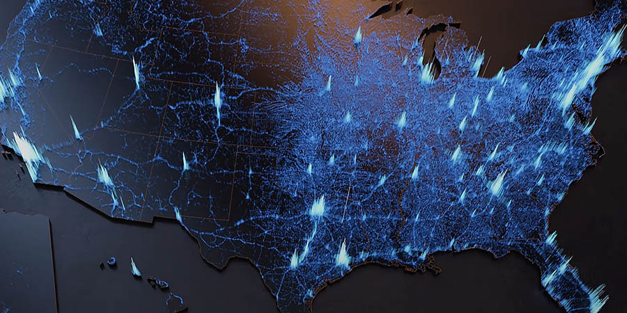
The US experiences a wide range of natural hazards from avalanches to wildfires, but many impact specific parts of the country. This #animatedmap of data from #FEMA shows which US communities are most at risk for 18 natural hazards. #mapsdotcom ow.ly/OgKN50SY21E


🐠🪸Coral reefs, the “canaries in the coal mine” for ocean health, are at risk of bleaching due to rising temperatures. Thanks to @NOAA’s Coral Reef Watch, we can monitor and protect these vital #ecosystems. Dive into the #interactivemap on #mapsdotcom. ow.ly/JZXb50Ru9jx


The US experiences a wide range of natural hazards from avalanches to wildfires, but many impact specific parts of the country. This #animatedmap of data from #FEMA shows which US communities are most at risk for 18 natural hazards. #mapsdotcom ow.ly/ToIM50SXP4p


GMTGIS | Esri Launches Maps.com On January 23, 2024 Esri launches , a groundbreaking platform dedicated to showcasing and celebrating the world’s most beautiful and remarkable maps. #GMTGIS #MapsDotCom #EsriMaps #GIS #Cartography #USVI
Anyone familiar with geography and health knows about John Snow and the mapping of cholera. What if what you know is wrong? Snow Mistake: Correcting Myths in the Mapping of Cholera ow.ly/SONM50W0imR #mapsdotcom

Hurricane Melissa recently battered Jamaica and the Caribbean. Learn how hot seas led to a record-breaking storm in this new map from #MapsDotCom: ow.ly/6e3850Xm4io

Anyone familiar with geography and health knows about John Snow and the mapping of cholera. What if what you know is wrong? Snow Mistake: Correcting Myths in the Mapping of Cholera ow.ly/pW9i50W3Qul #mapsdotcom

Anyone familiar with geography and health knows about John Snow and the mapping of cholera. What if what you know is wrong? Snow Mistake: Correcting Myths in the Mapping of Cholera ow.ly/ZHXj50W3Quk #mapsdotcom

Coral reefs, the “canaries in the coal mine” for ocean health, are at risk of bleaching due to rising temperatures. Thanks to @NOAA’s Coral Reef Watch, we can monitor and protect these vital #ecosystems. Dive into the #interactivemap on #mapsdotcom. esri.social/tSgg50SrTcG

If you love #maps, the new #mapsdotcom is now live and ready for visitors! Check it out 👇 hubs.li/Q02jLMQn0
Hurricane Melissa recently battered Jamaica and the Caribbean. Learn how hot seas led to a record-breaking storm in this new map from #MapsDotCom: ow.ly/o0GS50XpVvU


Hurricane Melissa recently battered Jamaica and the Caribbean. Learn how hot seas led to a record-breaking storm in this new map from #MapsDotCom: ow.ly/WmjV50Xmt1X

Hurricane Melissa recently battered Jamaica and the Caribbean. Learn how hot seas led to a record-breaking storm in this new map from #MapsDotCom: ow.ly/6e3850Xm4io
Hurricane Melissa recently battered Jamaica and the Caribbean. Learn how hot seas led to a record-breaking storm in this new map from #MapsDotCom: ow.ly/HVY150Xm4iS
Anyone familiar with geography and health knows about John Snow and the mapping of cholera. What if what you know is wrong? Snow Mistake: Correcting Myths in the Mapping of Cholera ow.ly/49Ic50W863e #mapsdotcom
Anyone familiar with geography and health knows about John Snow and the mapping of cholera. What if what you know is wrong? Snow Mistake: Correcting Myths in the Mapping of Cholera ow.ly/ZHXj50W3Quk #mapsdotcom
Anyone familiar with geography and health knows about John Snow and the mapping of cholera. What if what you know is wrong? Snow Mistake: Correcting Myths in the Mapping of Cholera ow.ly/pW9i50W3Qul #mapsdotcom
Anyone familiar with geography and health knows about John Snow and the mapping of cholera. What if what you know is wrong? Snow Mistake: Correcting Myths in the Mapping of Cholera ow.ly/SONM50W0imR #mapsdotcom
The US experiences a wide range of natural hazards from avalanches to wildfires, but many impact specific parts of the country. This #animatedmap of data from #FEMA shows which US communities are most at risk for 18 natural hazards. #mapsdotcom ow.ly/Orqw50T4pn3
The US experiences a wide range of natural hazards from avalanches to wildfires, but many impact specific parts of the country. This #animatedmap of data from #FEMA shows which US communities are most at risk for 18 natural hazards. #mapsdotcom ow.ly/OgKN50SY21E
The US experiences a wide range of natural hazards from avalanches to wildfires, but many impact specific parts of the country. This #animatedmap of data from #FEMA shows which US communities are most at risk for 18 natural hazards. #mapsdotcom ow.ly/ToIM50SXP4p
Coral reefs, the “canaries in the coal mine” for ocean health, are at risk of bleaching due to rising temperatures. Thanks to @NOAA’s Coral Reef Watch, we can monitor and protect these vital #ecosystems. Dive into the #interactivemap on #mapsdotcom. esri.social/tSgg50SrTcG
🐠🪸Coral reefs, the “canaries in the coal mine” for ocean health, are at risk of bleaching due to rising temperatures. Thanks to @NOAA’s Coral Reef Watch, we can monitor and protect these vital #ecosystems. Dive into the #interactivemap on #mapsdotcom. ow.ly/BppZ50RCUwF

🐠🪸Coral reefs, the “canaries in the coal mine” for ocean health, are at risk of bleaching due to rising temperatures. Thanks to @NOAA’s Coral Reef Watch, we can monitor and protect these vital #ecosystems. Dive into the #interactivemap on #mapsdotcom. ow.ly/c0VV50RymSr
🐠🪸Coral reefs, the “canaries in the coal mine” for ocean health, are at risk of bleaching due to rising temperatures. Thanks to @NOAA’s Coral Reef Watch, we can monitor and protect these vital #ecosystems. Dive into the #interactivemap on #mapsdotcom. ow.ly/sSWe50RymSc
🐠🪸Coral reefs, the “canaries in the coal mine” for ocean health, are at risk of bleaching due to rising temperatures. Thanks to @NOAA’s Coral Reef Watch, we can monitor and protect these vital #ecosystems. Dive into the #interactivemap on #mapsdotcom. ow.ly/JZXb50Ru9jx
🐠🪸Coral reefs, the “canaries in the coal mine” for ocean health, are at risk of bleaching due to rising temperatures. Thanks to @NOAA’s Coral Reef Watch, we can monitor and protect these vital #ecosystems. Dive into the #interactivemap on #mapsdotcom. ow.ly/8o4r50Rufce

🐠🪸Coral reefs, the “canaries in the coal mine” for ocean health, are at risk of bleaching due to rising temperatures. Thanks to @NOAA’s Coral Reef Watch, we can monitor and protect these vital #ecosystems. Dive into the #interactivemap on #mapsdotcom. ow.ly/TQaw50Rtb0f


Anyone familiar with geography and health knows about John Snow and the mapping of cholera. What if what you know is wrong? Snow Mistake: Correcting Myths in the Mapping of Cholera ow.ly/pW9i50W3Qul #mapsdotcom
Hurricane Melissa recently battered Jamaica and the Caribbean. Learn how hot seas led to a record-breaking storm in this new map from #MapsDotCom: ow.ly/HVY150Xm4iS
Where will you be on April 8? If you want to catch the solar eclipse at the right time, this striking map by @kennethfield on #mapsdotcom shows when and where totality will occur. 🌒☀️ #eclipse2024 ow.ly/CQGU50RaNwe
The US experiences a wide range of natural hazards from avalanches to wildfires, but many impact specific parts of the country. This #animatedmap of data from #FEMA shows which US communities are most at risk for 18 natural hazards. #mapsdotcom ow.ly/ToIM50SXP4p
🐠🪸Coral reefs, the “canaries in the coal mine” for ocean health, are at risk of bleaching due to rising temperatures. Thanks to @NOAA’s Coral Reef Watch, we can monitor and protect these vital #ecosystems. Dive into the #interactivemap on #mapsdotcom. ow.ly/sSWe50RymSc
Hurricane Melissa recently battered Jamaica and the Caribbean. Learn how hot seas led to a record-breaking storm in this new map from #MapsDotCom: ow.ly/6e3850Xm4io
GMTGIS | Esri Launches Maps.com On January 23, 2024 Esri launches , a groundbreaking platform dedicated to showcasing and celebrating the world’s most beautiful and remarkable maps. #GMTGIS #MapsDotCom #EsriMaps #GIS #Cartography #USVI
Infrastructure funding to repair America's decaying bridges is coming! 🌉 An interactive @Esri map pinpoints 200+ of the most at-risk bridges nationwide; it uses age, condition & daily traffic data to prioritize those needing repairs: ow.ly/kI2U50Q0QWK #bridges #mapsdotcom
Find the perfect campsite, navigate the next bend in the river, and discover the heavens from both the Northern and Southern Hemispheres with detailed star charts. Find your path at @mapsdotcom bit.ly/3hTKLax #sponsored @getoutmore #mapsdotcom #summerofwhere
Hurricane Melissa recently battered Jamaica and the Caribbean. Learn how hot seas led to a record-breaking storm in this new map from #MapsDotCom: ow.ly/WmjV50Xmt1X
Everybody needs a map. Get your next adventure dialed in with a quality @mapsdotcom trail and hiking map. bit.ly/3gHJMsE @getoutmore #mapsdotcom
The US experiences a wide range of natural hazards from avalanches to wildfires, but many impact specific parts of the country. This #animatedmap of data from #FEMA shows which US communities are most at risk for 18 natural hazards. #mapsdotcom ow.ly/OgKN50SY21E
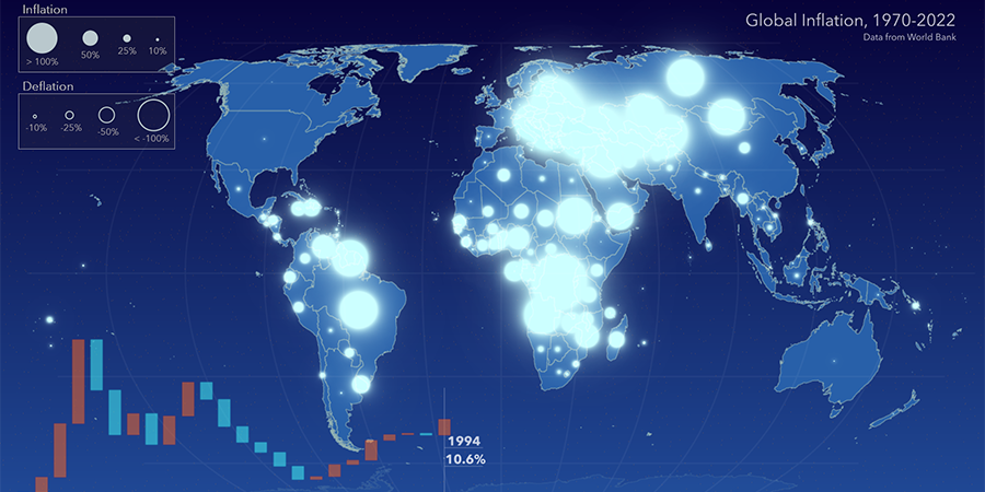
Explore 50+ years of inflation trends and how global averages and individual countries reflect changes with this animated map! 📈📉 See moments of extreme inflation & bouts of deflation through time: ow.ly/rzlS50Q3HZY #inflation #mapsdotcom #dataviz #globaleconomy
🐠🪸Coral reefs, the “canaries in the coal mine” for ocean health, are at risk of bleaching due to rising temperatures. Thanks to @NOAA’s Coral Reef Watch, we can monitor and protect these vital #ecosystems. Dive into the #interactivemap on #mapsdotcom. ow.ly/c0VV50RymSr
🐠🪸Coral reefs, the “canaries in the coal mine” for ocean health, are at risk of bleaching due to rising temperatures. Thanks to @NOAA’s Coral Reef Watch, we can monitor and protect these vital #ecosystems. Dive into the #interactivemap on #mapsdotcom. ow.ly/8o4r50Rufce
Anyone familiar with geography and health knows about John Snow and the mapping of cholera. What if what you know is wrong? Snow Mistake: Correcting Myths in the Mapping of Cholera ow.ly/49Ic50W863e #mapsdotcom
Anyone familiar with geography and health knows about John Snow and the mapping of cholera. What if what you know is wrong? Snow Mistake: Correcting Myths in the Mapping of Cholera ow.ly/ZHXj50W3Quk #mapsdotcom
If you love #maps, the new #mapsdotcom is now live and ready for visitors! Check it out 👇 hubs.li/Q02jLMQn0
🐠🪸Coral reefs, the “canaries in the coal mine” for ocean health, are at risk of bleaching due to rising temperatures. Thanks to @NOAA’s Coral Reef Watch, we can monitor and protect these vital #ecosystems. Dive into the #interactivemap on #mapsdotcom. ow.ly/JZXb50Ru9jx
Coral reefs, the “canaries in the coal mine” for ocean health, are at risk of bleaching due to rising temperatures. Thanks to @NOAA’s Coral Reef Watch, we can monitor and protect these vital #ecosystems. Dive into the #interactivemap on #mapsdotcom. esri.social/tSgg50SrTcG
Something went wrong.
Something went wrong.
United States Trends
- 1. Geno N/A
- 2. Lauryn Hill N/A
- 3. #SmackDown N/A
- 4. #LingOrmKeepWonderLand N/A
- 5. UConn N/A
- 6. #ENGENEs_For_SevEN N/A
- 7. Madison Booker N/A
- 8. Pat McAfee N/A
- 9. UCLA N/A
- 10. Cooper Flagg N/A
- 11. South Carolina N/A
- 12. #LenaMiuTwilightStand N/A
- 13. Lauren Betts N/A
- 14. LENAMIU CH3 LAND DOM N/A
- 15. All Falls Down N/A
- 16. Rob Lowe N/A
- 17. Simon's Cat N/A
- 18. Giannis N/A
- 19. #Boycott_HYBE_BELIFTLAB N/A
- 20. Sami N/A