#utilitymapping résultats de recherche

What could make the most experienced person in our masterclass react like this? 🤯 Find out soon... #GPR #SUE #utilitymapping #structuralmonitoring #civilengineering
Leica DT100 & DE100: Tilt compensation for precise utility mapping. Compact and efficient. hxgn.biz/44Z8jUV #UtilityMapping


The Underground Utility Mapping market is forecast to double by 2032, hitting USD 2,611.7 Mn at 9.55% CAGR. Explore drivers & top players. 🔗 Report here: credenceresearch.com/report/undergr… #UtilityMapping #SmartInfra #GeospatialTech


Locating underground utilities is difficult without accurate and detailed documentation. While some public utility maps are available upon request, private utilities remain unknown unless a private locator is called. #CNILocates #utilitymapping #undergroundutility


Sam Roberts FCInstCES presented PUMA, The Survey Association's new PAS128 Utility Mapping Accreditation on the main stage at #GEOBusiness. #UtilityMapping #surveying #CivilEngineering #geospatial #PAS128

The newest GPR detection system with innovative EsT technology is here: the Leica DS4000. Dig into the future: hxgn.biz/3I3JmhD #UtilityMapping #LeicaDS4000 #UtilityDetection #EsT #LeicaGeosystems


When certainty arrives before the first cut, how far can your team go, turning hidden utilities into clarity, confidence, and momentum on every project statewide? #BuildWithConfidence #ConstructionSafety #UtilityMapping
📍 We’re live at #EsriUC2025 this week! Explore how Leica Detection brings subsurface utility data into your GIS workflow. Visit us at booth #419 & discover what lies beneath! #UtilityMapping #GIS #LeicaDetection #LeicaGeosystems #GPR

Avoid costly surprises underground—discover UtilityScan Pro at #WETEX2025. Detect metallic & non-metallic utilities up to 12 m deep with ease. Visit dutcotennant.com/wetex/wetex-ex… for more details. #UtilityMapping #Surveying #InfrastructureSafety #GPRTechnology #GSSI #DutcoTennantLLC


sygma-solutions.com #SygmaSolutions #utilitymapping #utilitysurvey #undergroundmapping #groundpenetratingradar

Ready to deepen your understanding of utility detection & mapping? Check out our wealth of free resources! Whether it's EML, GPR, or GNSS - we've got you covered. Visit our learning section! hxgn.biz/3QPLMlI #UtilityMapping #Surveying #PureSurveying

Boost your underground utility detection with Ai.Maps, Stream DP, and Leica’s NDT Reveal system — for faster, smarter results. ⬇️ Explore more: hxgn.biz/43zAtEX #AiMaps #StreamDP #UtilityMapping #GPR #LeicaGeosystems #NDTReveal


Join us at tomorrow's @NCTCOG_Official Regional #GIS Mtg! @ChrisAkin98 will guide on strategically transforming utility data from back-room paper plans to centralized, accurate #DigitalTwin! Register: nctcog.org/regional-data/… #UtilityMapping #DigitalDoodle #CityMapping #NCTCOG

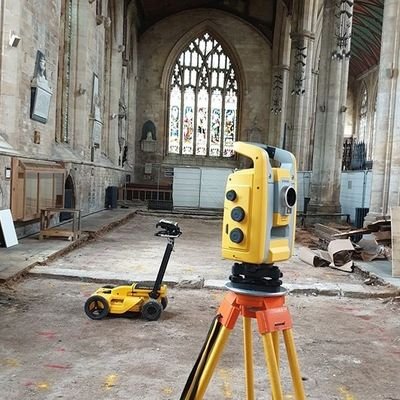
Ground penetrating radar (GPR) data from a recent PAS128 utility survey. GPR data doesn't get much better #utilitymapping #PAS128 #impulseradar
Dive deep into #utilitymapping! Download our growth guide funnelled with knowledge to fuel your growth in the surveying business. Don’t just adapt; lead the change. Download here: hxgn.biz/4bfoYDY #GPR #GrowthRoadmap #Surveying #PureSurveying

Revolutionise your #surveying business with Stream DP! Learn how 3D #UtilityMapping can unlock new potentials in our latest blog. Don’t miss out, read now for a front-row seat on your journey to growth. Discover more: hxgn.biz/3UH6uFj #PureSurveying


Our comprehensive surveys go beyond the surface, confirming the location of sewer and drainage pipes, monitoring their condition, and identifying blockages or structural defects. Contact us today for drainage and utility survey services. #DrainageSurvey #UtilityMapping


Utility Mapping is The Backbone of Urban Development! Let’s map the future, one utility at a time. polosoftech.com/geospatial-ind… #UtilityMapping #UrbanPlanning #LiDAR #LiDARDataProcessing #InfrastructureDevelopment #GovernmentApproval #SmartCities #UrbanDesign #PolosoftTechnologies
When certainty arrives before the first cut, how far can your team go, turning hidden utilities into clarity, confidence, and momentum on every project statewide? #BuildWithConfidence #ConstructionSafety #UtilityMapping

At Epitome Geo-Technical Services, we combine advanced technology, cutting-edge equipment, and expert project management to map underground utilities with unmatched accuracy. +91-96756 94400 📷epitomegs.com #EpitomeGeoTechnical #UndergroundUtilitySurvey #UtilityMapping

Utility Mapping is The Backbone of Urban Development! Let’s map the future, one utility at a time. polosoftech.com/geospatial-ind… #UtilityMapping #UrbanPlanning #LiDAR #LiDARDataProcessing #InfrastructureDevelopment #GovernmentApproval #SmartCities #UrbanDesign #PolosoftTechnologies

Future-ready infrastructure starts below ground. Leica DS4000 Utility Detection Radar delivers dual-frequency precision & real-time mapping to reveal hidden utilities fast and accurately. Learn more 👉 sitml.com/product/leica-… #LeicaDS4000 #UtilityMapping #GeospatialInnovation

What could make the most experienced person in our masterclass react like this? 🤯 Find out soon... #GPR #SUE #utilitymapping #structuralmonitoring #civilengineering
Avoid costly surprises underground—discover UtilityScan Pro at #WETEX2025. Detect metallic & non-metallic utilities up to 12 m deep with ease. Visit dutcotennant.com/wetex/wetex-ex… for more details. #UtilityMapping #Surveying #InfrastructureSafety #GPRTechnology #GSSI #DutcoTennantLLC
At Epitome Geo-Technical Services, we combine advanced technology, cutting-edge equipment, expert project management to map underground utilities with unmatched accuracy. 📞+91-96756 94400 🌐epitomegs.com #EpitomeGeoTechnical #UndergroundUtilitySurvey #UtilityMapping

See the unseen. Leica Stream DP GPR Dual-polarized antennas Real-time 3D visualization Maximum depth penetration Utility mapping with confidence. sitml.com/product/stream… #LeicaGeosystems #UtilityMapping #TechInnovation

Building tomorrow starts beneath the surface. The Leica DS2000 Utility Detection Radar ensures safer, faster, and smarter underground mapping. 🔗 sitml.com/product/leica-… #LeicaGeosystems #UtilityMapping #SmartInfrastructure


PRODUCT I The Locator that can make the world stop and stare. 👀 Accurately locate underground assets with advanced locator technology – available through Savitri Telecom Services. Know more: savitritelecom.com/products/marke… #UtilityMapping #RouteMarking #SmartInfrastructure
@Epitomegs_, accurate mapping of underground utilities is vital for minimizing risks in construction. How does your team ensure precision while managing project timelines? 🛠️ #UtilityMapping
At Epitome Geo-Technical Services, we combine advanced technology, cutting-edge equipment, expert project management to map underground utilities with unmatched accuracy. 📷+91-96756 94400 📷 epitomegs.com #EpitomeGeoTechnical #UndergroundUtilitySurvey #UtilityMapping


Underground-utility mapping combines ground-penetrating radar and ML to classify pipe materials and depths, cutting utility strike risks by 70 % on urban projects .#UtilityMapping #GPR
📍 O2 Peninsular Square Our team recently completed a 3D PAS128 GPR Utility Mapping and 3D Topographical Survey, delivering accurate, detailed data. #UtilityMapping #TopographicalSurvey #PAS128 #GPR #Surveying #Construction #ProjectDelivery


Leica DT100 & DE100: Tilt compensation for precise utility mapping. Compact and efficient. hxgn.biz/44Z8jUV #UtilityMapping
The Underground Utility Mapping market is forecast to double by 2032, hitting USD 2,611.7 Mn at 9.55% CAGR. Explore drivers & top players. 🔗 Report here: credenceresearch.com/report/undergr… #UtilityMapping #SmartInfra #GeospatialTech
The newest GPR detection system with innovative EsT technology is here: the Leica DS4000. Dig into the future: hxgn.biz/3I3JmhD #UtilityMapping #LeicaDS4000 #UtilityDetection #EsT #LeicaGeosystems
Unmask the underground. Locating pipes and utilities with precision. Trust C-N-I Locates LTD's expertise. #UndergroundMapping #UtilityMapping #HiddenInfrastructure #MappingSolutions #UndergroundDetection #UtilityManagement #InfrastructurePlanning #AccurateMapping #CNILocates

sygma-solutions.com #SygmaSolutions #utilitymapping #utilitysurvey #undergroundmapping #groundpenetratingradar
Locating underground utilities is difficult without accurate and detailed documentation. While some public utility maps are available upon request, private utilities remain unknown unless a private locator is called. #CNILocates #utilitymapping #undergroundutility

Utility surveys play a significant role in ensuring safety and project success. GPR is a non-invasive technique. This technology can detect non-metallic pipes, fiber optic cables, and other critical infrastructure that is otherwise difficult to locate. #utilitymapping #gprsurvey

Our private utility locating services provide vital insights into subsurface utilities, structures, and objects, enhancing your project planning and execution. Reach out to our experts to schedule work or learn more! #UndergroundMapping #UtilityMapping #HiddenInfrastructure

Ready to deepen your understanding of utility detection & mapping? Check out our wealth of free resources! Whether it's EML, GPR, or GNSS - we've got you covered. Visit our learning section! hxgn.biz/3QPLMlI #UtilityMapping #Surveying #PureSurveying
📍 We’re live at #EsriUC2025 this week! Explore how Leica Detection brings subsurface utility data into your GIS workflow. Visit us at booth #419 & discover what lies beneath! #UtilityMapping #GIS #LeicaDetection #LeicaGeosystems #GPR

Continued utility strikes? See how SiteMap® can help. Click here to learn more: hubs.li/Q02zQrN60 #UtilityMapping #DamagePrevention #UtilityStrikes #FacilityManagement #ConstructionManagement #AsBuilts #Utilities #FacilityManagers

Boost your underground utility detection with Ai.Maps, Stream DP, and Leica’s NDT Reveal system — for faster, smarter results. ⬇️ Explore more: hxgn.biz/43zAtEX #AiMaps #StreamDP #UtilityMapping #GPR #LeicaGeosystems #NDTReveal
Sam Roberts FCInstCES presented PUMA, The Survey Association's new PAS128 Utility Mapping Accreditation on the main stage at #GEOBusiness. #UtilityMapping #surveying #CivilEngineering #geospatial #PAS128
Dive deep into #utilitymapping! Download our growth guide funnelled with knowledge to fuel your growth in the surveying business. Don’t just adapt; lead the change. Download here: hxgn.biz/4bfoYDY #GPR #GrowthRoadmap #Surveying #PureSurveying
Revolutionise your #surveying business with Stream DP! Learn how 3D #UtilityMapping can unlock new potentials in our latest blog. Don’t miss out, read now for a front-row seat on your journey to growth. Discover more: hxgn.biz/3UH6uFj #PureSurveying

After a superb lunch & tour of @LFC it is time for Sam Roberts to launch TSA’s #PUMA scheme - #PAS128 accreditation which is now live @LRQA #UtilityMapping #RaisingStandards

Join us at tomorrow's @NCTCOG_Official Regional #GIS Mtg! @ChrisAkin98 will guide on strategically transforming utility data from back-room paper plans to centralized, accurate #DigitalTwin! Register: nctcog.org/regional-data/… #UtilityMapping #DigitalDoodle #CityMapping #NCTCOG
Something went wrong.
Something went wrong.
United States Trends
- 1. Columbus 141K posts
- 2. President Trump 1.03M posts
- 3. Middle East 237K posts
- 4. #IndigenousPeoplesDay 10K posts
- 5. Brian Callahan 6,077 posts
- 6. Seth 46.5K posts
- 7. Thanksgiving 52.9K posts
- 8. #WWERaw 52.3K posts
- 9. Macron 201K posts
- 10. Marc 46.7K posts
- 11. Darius Smith 3,556 posts
- 12. HAZBINTOOZ 4,156 posts
- 13. Apple TV 4,992 posts
- 14. Shildt 2,488 posts
- 15. Titans 35.8K posts
- 16. Vrabel 6,249 posts
- 17. Egypt 243K posts
- 18. Cape Verde 4,481 posts
- 19. Flip 52.2K posts
- 20. #drwfirstgoal N/A