#utmap search results

Hello from Utah! Yesterday I had my first opportunity as a student ,to display a map I created. The event was ‘Maps on the Hill’ at the State capital building, hosted by the Utah Geospatial Resource Center (UGRC). #utmap #gischat #shamelessplug


☝️With all the rage about AI chatbots, I asked the new Bing for a tweet about geospatial data resources in Utah. Did it hit the mark? #geospatial #utmap #gis @MapUtah @utahgeological

Here's an updated look at the Great Salt Lake from 4/30/2023, almost exactly 1 year after the previous image. It's looking a little better and there's a LOT more snow still in the mountains this year. #utmap #gis #geospatial (from SentinelHub EO Browser)


This was one of my final projects at UGRC. It was a lot of fun to scale up an object detection model to scan our statewide imagery and generate spatial data. #gis #geospatial #utmap


Hot off the press 🗞📬📰 Results Update: Detecting Cooling Towers with Computer Vision Tools ift.tt/6cLkgdI #utmap #opendata #utahopendata #utahgis #gis
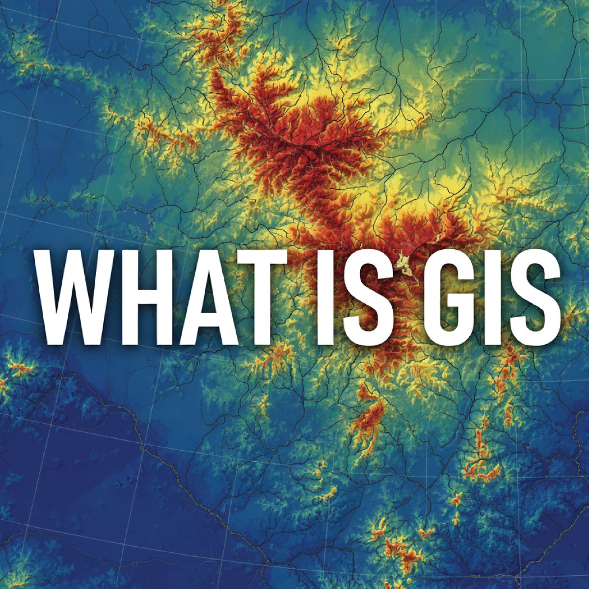
Ever wondered how your GPS finds the fastest route or how cities plan new neighborhoods? The answer is GIS! GIS combines mapping with data to help us understand the 'where' of everything. It's the science of location, helping us make smarter decisions. #utmap #gis #ugrc #utahgis
🏙 Many cities look a little different from a bird’s eye view. Can you guess which city this one is? The answer to last week’s WIIW was Sand Hollow Reservoir. If that was your guess, awesome job! 👏 #whereisitwednesday #utmap #gis #ugrc #utahgis


UTmapさんに紹介していただきました!📣 ぜひこちらからもチェックお願いします!! #春から東大 #東京大学ラグビー部 #UTmap
▼ #春から東大 サークル紹介 東大ラグビー部 @TURFC_recruit ↓もっとくわしく atlas-career.jp/utmap/club/4077

「文科Ⅰ類から法学部に進学した後、事業立ち上げや留学を経験し、新卒でVCのジャフコ グループ株式会社に入社された、 白川亜祐旭さんのインタビューをお届けします」 【VC】官僚志望だった文Ⅰ生がVCとして起業家をサポートすることになった理由とは? campus-map.jp/ut/report/061/ #UTmap

🚮🗑️🚮 Deprecation Notice 🚮🗑️🚮 Utah Avalanche Rose Tri Canyons github.com/agrc/porter/is… #utmap #ugrcporter

We had a great discussion about addressing,911 and how good accurate data is key #utmap


🌱🌱The SGID is growing🌳🌳 2025 Tax Entities from the Tax Commission are coming soon! github.com/agrc/porter/is… Follow along and comment if you are interested! #utmap #ugrcporter

Due to expected bad weather, tomorrow's SLUG meeting has been pushed back to Wednesday, 15 March at 10:30am at the Taylorsville State Office Building. See you then! @MapUtah #utmap #gis #geospatial

The 53rd Quarterly Salt Lake GIS User Group (SLUG) 03-15-2023 - DATE CHANGE!!! - mailchi.mp/bf3556db1624/t…

We aligned the address system grid names in both the roads and address points with this update. Did you notice they were out of sync? Probably not. But the outcome of this effort is massive geocoding improvements. Enjoy. #utmap #gischat
Hot off the press 🗞📬📰 Utah SGID Statewide Roads Data Layer Updates 01/12/2023 ift.tt/QfFt5D7 #utmap #opendata #utahopendata #utahgis #gis
It's been a year since @MapUtah launched the open source places dataset and it's grown by over 3,100 features in that first year! It now contains more than 26,500 points and gets updated every 2 weeks (usually on a Wednesday). #utmap #gis #geospatial
This was a really fun dataset to work on. It's got a lot of interesting places that could be used for a variety of purposes and analyses. Plus, anyone can contribute via @openstreetmap! #utmap #gischat

🚮🗑️🚮 Deprecation Notice 🚮🗑️🚮 Utah Broadband Service github.com/agrc/porter/is… #utmap #ugrcporter

Hot off the press 🗞📬📰 Utah SGID Statewide Roads Data Layer Updates ift.tt/NHrzfDY #utmap #opendata #utahopendata #utahgis #gis #ugrc-update
gis.utah.gov
UGRC - Utah SGID Statewide Roads Data Layer Updates
UGRC recently completed updates to the SGID Roads data layer. Please visit our Roads and Highway System data page where you will find information about the Roads data model, as well as a web service l
🚮🗑️🚮 Deprecation Notice 🚮🗑️🚮 Utah Law Enforcement is being replaced by Utah Law Enforcement Locations github.com/agrc/porter/is… #utmap #ugrcporter

We can’t tell you why the chicken 🐔 crossed the road, but we can tell you which road it crossed thanks to our collection of transportation data. Check it out now! gis.utah.gov/products/sgid/… #UGRC #utmap #GIS #Mapping #Geography #DataScience

Hot off the press 🗞📬📰 Unlock secure automated code signing with Google Cloud KMS ift.tt/E34CfKU #utmap #opendata #utahopendata #utahgis #gis #ugrc-update

Hot off the press 🗞📬📰 Introducing New and Improved Residential Broadband Data and Maps ift.tt/QX9IRm1 #utmap #opendata #utahopendata #utahgis #gis #ugrc-update

🌱🌱The SGID is growing🌳🌳 Average Annual Precipitation from PRISM Group, Oregon State University, prism.oregonstate.edu, data created Dec 2022, accessed 30 Oct 2025 is coming soon! github.com/agrc/porter/is… Follow along and comment if you are interested! #utmap #ugrcporter

🚮🗑️🚮 Deprecation Notice 🚮🗑️🚮 2022 Tax Entities are moving the the shelf. github.com/agrc/porter/is… Read about Shelved datasets on our website gis.utah.gov/documentation/… #utmap #ugrcporter

🚮🗑️🚮 Deprecation Notice 🚮🗑️🚮 2021 Tax Entities are moving the the shelf. github.com/agrc/porter/is… Read about Shelved datasets on our website gis.utah.gov/documentation/… #utmap #ugrcporter
🚮🗑️🚮 Deprecation Notice 🚮🗑️🚮 2021 Tax Areas are moving the the shelf. github.com/agrc/porter/is… Read about Shelved datasets on our website gis.utah.gov/documentation/… #utmap #ugrcporter
🚮🗑️🚮 Deprecation Notice 🚮🗑️🚮 2022 Tax Areas are moving the the shelf. github.com/agrc/porter/is… Read about Shelved datasets on our website gis.utah.gov/documentation/… #utmap #ugrcporter
🌱🌱The SGID is growing🌳🌳 2025 Tax Entities from the Tax Commission are coming soon! github.com/agrc/porter/is… Follow along and comment if you are interested! #utmap #ugrcporter
🌱🌱The SGID is growing🌳🌳 Law Enforcement Locations from BCI are coming soon replacing the outdated gis.utah.gov/products/sgid/… with current data and a new simplified schema! github.com/agrc/porter/is… Follow along and comment if you are interested! #utmap #ugrcporter

Ever wondered how your GPS finds the fastest route or how cities plan new neighborhoods? The answer is GIS! GIS combines mapping with data to help us understand the 'where' of everything. It's the science of location, helping us make smarter decisions. #utmap #gis #ugrc #utahgis
Hot off the press 🗞📬📰 Utah SGID Statewide Roads Data Layer Updates ift.tt/Tr2b4h0 #utmap #opendata #utahopendata #utahgis #gis #ugrc-update
gis.utah.gov
UGRC - Utah SGID Statewide Roads Data Layer Updates
UGRC recently completed updates to the SGID Roads data layer. Please visit our Roads and Highway System data page where you will find information about the Roads data model, as well as a web service l
🏙 Many cities look a little different from a bird’s eye view. Can you guess which city this one is? The answer to last week’s WIIW was Sand Hollow Reservoir. If that was your guess, awesome job! 👏 #whereisitwednesday #utmap #gis #ugrc #utahgis
🚮🗑️🚮 Deprecation Notice 🚮🗑️🚮 Utah Broadband Service github.com/agrc/porter/is… #utmap #ugrcporter
🚮🗑️🚮 Deprecation Notice 🚮🗑️🚮 Utah Avalanche Rose Tri Canyons github.com/agrc/porter/is… #utmap #ugrcporter
🌱🌱The SGID is growing🌳🌳 Broadband Service Areas from the Utah Broadband Center coming soon! github.com/agrc/porter/is… Follow along and comment if you are interested! #utmap #ugrcporter


Hello from Utah! Yesterday I had my first opportunity as a student ,to display a map I created. The event was ‘Maps on the Hill’ at the State capital building, hosted by the Utah Geospatial Resource Center (UGRC). #utmap #gischat #shamelessplug
☝️With all the rage about AI chatbots, I asked the new Bing for a tweet about geospatial data resources in Utah. Did it hit the mark? #geospatial #utmap #gis @MapUtah @utahgeological
🏙 Many cities look a little different from a bird’s eye view. Can you guess which city this one is? The answer to last week’s WIIW was Sand Hollow Reservoir. If that was your guess, awesome job! 👏 #whereisitwednesday #utmap #gis #ugrc #utahgis
💧 It’s time for this week’s #WhereisitWednesday! This lake shares part of its area with another nearby state. Do you know which one and what the lake is called? For those of you who guessed Canyonlands National Park for last week’s WIIT, nice job! 🙌 #utmap #gis #ugrc #utahgis

Ever wondered how your GPS finds the fastest route or how cities plan new neighborhoods? The answer is GIS! GIS combines mapping with data to help us understand the 'where' of everything. It's the science of location, helping us make smarter decisions. #utmap #gis #ugrc #utahgis
For this map of the month, we’re headed to prehistoric times with this map of Lake Bonneville from Max Richmond. You can learn more about Lake Bonneville and how we use data to understand it from the @utah_dnr : storymaps.arcgis.com/stories/f50111… #mapofthemonth #utmap #gis #ugrc #utahgis

This looks like some kind of animal…maybe an animal spirit with a less corporeal form. But where can it be found in Utah? 🐻 If you guessed Bear Lake for last week’s “Where is it Wednesday,” great work! We can’t get anything past you! #whereisitwednesday #utmap #gis #ugrc

🚵♀️This week’s #whereisitwednesday is near a famous mountain bike trail. Can you guess which one? Did you guess Mona Reservoir for last week’s “Where is it Wednesday”? If so, great job!! #utmap #gis #ugrc #utahgis

This was one of my final projects at UGRC. It was a lot of fun to scale up an object detection model to scan our statewide imagery and generate spatial data. #gis #geospatial #utmap
Hot off the press 🗞📬📰 Results Update: Detecting Cooling Towers with Computer Vision Tools ift.tt/6cLkgdI #utmap #opendata #utahopendata #utahgis #gis
This aerial image of a beloved National Monument looks very different from a bird’s eye view–can you guess which monument it is? #whereisitwednesday #utmap #gis #ugrc #utahgis

Here's an updated look at the Great Salt Lake from 4/30/2023, almost exactly 1 year after the previous image. It's looking a little better and there's a LOT more snow still in the mountains this year. #utmap #gis #geospatial (from SentinelHub EO Browser)
It may be getting closer to fall, but that doesn’t mean fire season is over yet. For this Map of the Month, we’re showcasing that many different departments can work together to use GIS to map evacuation routes and staging areas. #utmap #gis #ugrc #utahgis

🥾Utah is home to five national parks. Can you guess which one is visible in this image? The answer to last week’s “Where is it Wednesday” was the Colorado River near Dead Horse Point State Park and Moab. #whereisitwednesday #utmap #gis #ugrc #utahgis

🎧 Did you know all episodes from the UGRC Geospatial Podcast are now available on our website? Check it out today for thoughtful conversations on how GIS is being used throughout the state: gis.utah.gov/collaboration/… #utmap #gis #ugrc #utahgis #podcast

💧 The Utah's Watershed Restoration Initiative (@UtahWRI) is just one of the many orgs using Discover imagery to improve daily life in Utah. 👉Learn more about the WRI: wri.utah.gov/wri/map/map.ht… ✅Sign up for Discover here: gis.utah.gov/products/disco… #utmap #gis #ugrc #utahgis

The 2026 UGIC Conference will be held in Kanab, UT from May 4-8, 2026. Come join us for a week filled with training, presentations, networking, cartography, coding, & more! Sign up for the UGIC mailing list for updates: ugic.org #utmap #gis #ugrc #utahgis #ugic

Want to learn more about the 3D Elevation Program and the 3D Hydrography Program? The @usgs webinar will be held this Wednesday at 11am MT! There’s still a chance to register here: usgs.gov/3d-national-to… #utmap #gis #ugrc #utahgis #usgs

🤓 Did you know that UGRC, in collaboration with the Utah Department of Environmental Quality (@utahdeq), has a map where you can view all kinds of layers from oil and gas wells to water quality? Check it out here: enviro.deq.utah.gov #utmap #gis #ugrc #utahgis #didyouknow

We can’t tell you why the chicken 🐔 crossed the road, but we can tell you which road it crossed thanks to our collection of transportation data. Check it out now! gis.utah.gov/products/sgid/… #UGRC #utmap #GIS #Mapping #Geography #DataScience
Something went wrong.
Something went wrong.
United States Trends
- 1. #UFC322 165K posts
- 2. Islam 270K posts
- 3. Morales 37.3K posts
- 4. Valentina 16K posts
- 5. Sark 6,084 posts
- 6. Kirby 18.8K posts
- 7. Georgia 89.4K posts
- 8. Ilia 5,641 posts
- 9. Khabib 9,360 posts
- 10. Zhang 26.9K posts
- 11. Ole Miss 12.4K posts
- 12. #GoDawgs 9,715 posts
- 13. Leon 74.6K posts
- 14. Dagestan 2,122 posts
- 15. Arch 22.5K posts
- 16. Sean Brady 6,902 posts
- 17. Dillon Danis 11K posts
- 18. Tanner Wall N/A
- 19. Usman 10.6K posts
- 20. Ahmad Hardy 1,355 posts