
GIS Whispers
@spatialiser
QGIS tinkerer, landscape archaeologist. I'm also @ZCuckovic
You might like


Landscape chambers: a new method for (cognitive) landscape analysis. Insight: landscapes are composed of specific spaces, such as mountains or valleys. Problem: how to delimit such spaces ? Below: a non-trivial topography (Puy-de-Dôme, France) and modelled landscape areas.


After making a massive $7.19 in 4 months (less than the $10 payout threshold), I've decided to start ungating my Medium-hosted tutorials (it's not really in the knowledge-sharing spirit anyway!) and migrate them to my website, starting with... helenmakesmaps.com/post/how-to-ma…
helenmakesmaps.com
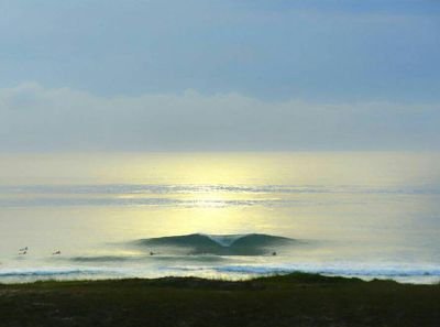
How to make a firefly map with QGIS
Follow this quick and easy guide to create stunning firefly maps with QGIS! 🌟


🔵💃📊 Dernier tango pour l’indigo Lorsque l’indigo arrive en France au XVIe, il est tout de suite perçu comme une menace pour un autre colorant bleu, bien français celui-ci : le pastel. Qui sortira vainqueur de cette valse des colorants ? N'insistez pas je vous le raconte ⬇️

💰🦗🔴 « Le trésor de l'insecte du rouge » Comment un minuscule parasite, la cochenille, devient au XVIe siècle un objet de convoitise et de contrebande, jalousé par l'Europe entière Une histoire de pirates, d'insecte, de commerce mondiale et de riches étoffes🧶⬇️


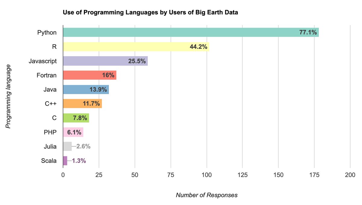
Releasing a new Google #EarthEngine workshop titled "Creating Publication Quality Charts with GEE" with completely open materials and code. A structured guide to help you create beautiful and informative visualizations from climate and earth observation datasets. A thread (1/n)👇


Super cool 🤓🤓 : animated shadows in #QGIS. Made with Terrain Shading plugin, with a help of a dedicated script (London city Lidar data). plugin : landscapearchaeology.org/qgis-terrain-s… script : github.com/zoran-cuckovic… The script is bare bone Python - but not excessively technical, I hope...

Richard Edes Harrison (1901-1994) made maps that radically changed our world view. As chief cartographer for Fortune Magazine, Harrison developed mapping concepts later found in GIS, data visualization, and thematic cartography. See 142 of his maps: davidrumsey.com/luna/servlet/s…


Using #RStats and #QGIS and working on Linux? You may want to try github.com/JanCaha/qgis-c… C++ plugin to run R inside QGIS. Allows seamless integration of R with QGIS. The initial work on this was done by @nyalldawson. The plugin needs to be compiled locally to work.
#GDAL Pro Tip: gdal_viewshed command can do visibility analysis using elevation datasets. Here's an example taking the 1m resolution DSM of London to determine all areas that will be visible from the top of the Tower 42 building. courses.spatialthoughts.com/gdal-tools.htm…


There's a new programming language in town - it's Mojo! I'm more than a little excited about it. It's Python, but with none of Python's problems. You can write code as fast as C, and deploy small standalone applications like C. My post is below, and a 🧵 fast.ai/posts/2023-05-…


Out now – How to Read a Tree: Clues & Patterns from Roots to Leaves nhbs.com/how-to-read-a-… A root-to-tip detective guide on how to reveal the details of a tree's life using visible clues that are easily missed. @NaturalNav @SceptreBooks @HodderBooks @BSBIbotany @Botanical_ @ASPB


Thanks, this is great!

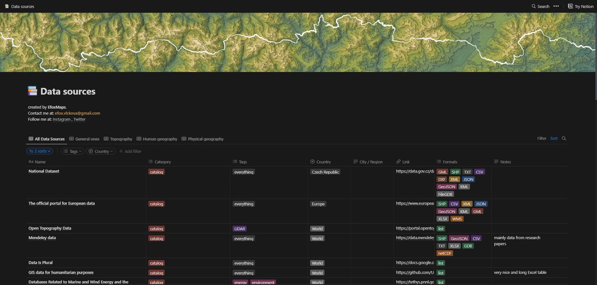
Data. I finally compiled the list of about 200 data resoures. Have fun 😊 tinyurl.com/spatialdataa #gischat

Read about the vintage style map of 1940s #Paris I designed for Cara Black's 2020 novel Three Hours In Paris Commissioned by @soho_press ℹ️ thisismikehall.com/1940s-paris


Coloring polygons on-the-spot with raster_value for a hillshade effect in #qgis


Dans mon grenier je viens de retrouver une machine à calculer #Curta. A coup de manivelle on peut additionner, soustraire, multiplier, diviser avec ou sans virgule ! C’est génial ! Qui connaît ?


Please steal the map by @hokkaidowilds , it's worth it ! hokkaidowilds.org/how-to-create-…
hokkaidowilds.org
Please steal our Japan (Niseko) backcountry ski map | HokkaidoWilds.org
Recently on HokkaidoWilds.org, we published our first ever physical map, Niseko Backcountry. See the companion site here. In this post, we detail how you can use publicly available Japan government…


United States Trends
- 1. Veterans Day 284K posts
- 2. Veterans 448K posts
- 3. Luka 76.9K posts
- 4. Nico 130K posts
- 5. Mavs 29.8K posts
- 6. Gambit 32.7K posts
- 7. Kyrie 6,932 posts
- 8. Wike 79.1K posts
- 9. Sabonis 2,533 posts
- 10. Dumont 24.1K posts
- 11. #csm220 7,118 posts
- 12. Vets 25.2K posts
- 13. #MarvelRivals 30.4K posts
- 14. Rogue 45K posts
- 15. Wanda 23.4K posts
- 16. Jay Rock 2,543 posts
- 17. Pat McAfee 2,421 posts
- 18. Arlington National Cemetery 14.2K posts
- 19. Strategist 8,557 posts
- 20. #MFFL 2,374 posts


Something went wrong.
Something went wrong.