Storm Mapping
@storm_mapping
Interactive weather archive where you can view weather events like never before! Search daily weather events and notable extreme past weather events!
You might like


Lightning Flash Density product showing quite the light show this evening from Chicago to Detroit. #ilwx #inwx #miwx #ohwx

EXCITED to speak on storm chasing and launching rockets into tornadoes at the upcoming STORMINAR in Orlando, FL on March 27-28! The Dominator 1 is scheduled to appear as well! For details check out storminar.com


Do something different for storm season 2020! Come learn the insurance replacement industry or scale your existing business! Learn more at storminar.com @lilly_wx @ReedTimmerAccu @mkosullivan1 @gafroofing @MerlinLawGroup @meteodon
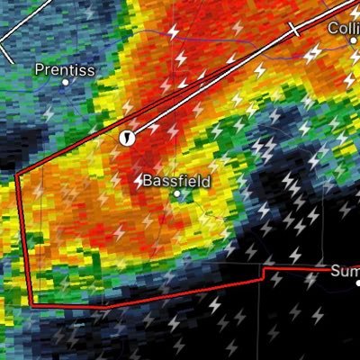
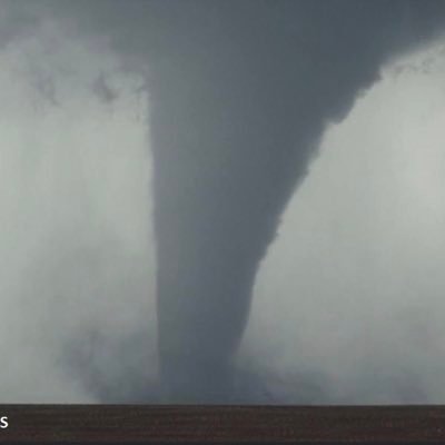
Here's a textbook look at a hook echo with the currently Particularly Dangerous Situation with OBSERVED Tornado Warning that is for southeastern Vernon Parish, Louisana until Noon CST. #LAWX


Check out this overview of severe weather activity since the start of 2019. This combines many different datasets to provide a probability of damage caused by hail/wind events throughout the Plains and Midwest. The timelapse is nearly 1/hr of data processing to complete the grid.
Impressive visualization of probability of damage caused by hail and wind. This is run starting from January 1st to November 14th.

Probability of damage caused by severe weather (hail - wind) from the start of 2019 to Nov 14th. Algorithm assigns impact score for each grid point. Always interesting to see data progression over the Rocky Mtns into the Plains.
Animation loop from early this morning to late this afternoon of #HurricaneDorian - Note the near stationary movement all day hammering the northern Bahamas.
THREAD 1/3: Hurricane Hunters find #HurricaneDorian as a Category 3 major hurricane. Check out the clearing of the eye within Dorian just a few minutes ago showing the intensification of this storm. You can see the explosive convection flaring up to the southwest of the eye.
The National Hurricane Center is now forecasting Dorian to strengthen to a Major Hurricane over the weekend! #TropicalStormDorian
The risk of dangerous storm surge & hurricane-force winds is increasing along the Florida east coast, although it is too soon to determine where. All indications are that by this weekend, a powerful hurricane will be near the Florida or SE coast of the U.S. #TropicalStormDorian

We are closely monitoring a tropical wave over the Bahamas that continues to slowly organize. The National Hurricane Center has set odds for development within the next 5 days to 50%. If this system develops the next name on the list for the 2019 hurricane season is Dorian.


New addition to the enhanced data viewer in RadarOmega app- Live Geostationary Lightning Flash Mapper with Group Energy Density and Group Flash Count Density! Check out some visualizations from a few hours this afternoon.
Check out this long duration loop showing the progression of a long lived Mesoscale Convective System from early this am through this afternoon. Wind damage impact from NE to IL. #ilwx #MOwx #KSwx #NEwx
Check out this impressive supercell in progress late this afternoon in SW Texas! This storm is capable of hail sizes up to softball size. Thankfully this storm is remaining over rural areas. #txwx #severeweather
Numerous Severe Thunderstorms developing over portions of eastern Ohio extending into western Pennsylvania. These storms are capable of hail up to 2” in diameter along with a #tornado risk developing further east. Stay weather aware! #pawx #ohwx #njwx
Incredible scenes late this afternoon near Hugo, Colorado as thunderstorms are developing off in the distance! #cowx


Some damage noted from storms already this morning with a likely tornado. #vawx


RadarOmega users.. We have a fairly significant update that is now available. We have increased the resolution of our Differential Reflectivity and Correlation Coefficient products for the lowest elevations! No app update is required, these changes have already taken effect!

Check out this impressive radar presentation off the coast of North Carolina this afternoon as a nor’easter continues to strengthen.
Android users.. The latest RadarOmega update includes storm tracks with detailed storm attribute data. You can find the settings for this in "Display Settings" in the side menu options. iOS users, this feature has been available for over a week now. Expect more to come!


@NWSMelbourne had a busy morning as severe weather with large hail impacted the space coast! Check out this animation starting early this am through this afternoon from KMLB NEXRAD. You can clearly see when increased SAILS scans started as activity developed.


United States Trends
- 1. Bama 16.8K posts
- 2. Oklahoma 25.7K posts
- 3. Ty Simpson 3,592 posts
- 4. #UFC322 30.1K posts
- 5. BOOMER SOONER 1,706 posts
- 6. Iowa 18.8K posts
- 7. Mateer 3,033 posts
- 8. Jungkook 243K posts
- 9. Brent Venables N/A
- 10. #RollTide 3,142 posts
- 11. South Carolina 33.4K posts
- 12. #EubankBenn2 30.2K posts
- 13. Kline 1,533 posts
- 14. Ryan Williams 1,693 posts
- 15. Heisman 10.5K posts
- 16. Arbuckle 1,041 posts
- 17. Georgia Tech 2,624 posts
- 18. DeBoer 1,298 posts
- 19. Talty 1,554 posts
- 20. #USMNT 1,283 posts
You might like
-
 Atmospheric Chaos
@ColtForney -
 Josh Alecci
@AlecciJosh -
 Nicole Loeffler
@chaserchick17 -
 Nick Nolte
@NickNolteWx -
 JCStormChaser
@Txstormchase -
 Ed Sweeney
@EasternChaser -
 Mobile Weather Office
@MobileWxOffice -
 Craig Tillison
@Craig_wx_T -
 Alex Heimberger
@TAStormChasing -
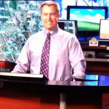
 Paul Goddard
@PGoddardNews -
 highplainstours
@highplainstours -
 Tim Carley
@cavreconpilot -
 Steve Miller
@SteveMillerOK
Something went wrong.
Something went wrong.